Marilyn O. Ruiz
Military Digging Permit Process Goes Geospatial
The request for a permit for excavation is a common occurrence at military installations. Military training maneuvers require trenches and tank traps, while cantonment area activities include various construction projects. Requests are reviewed to avoid disturbing sensitive wildlife habitat, archeological resources, and existing infrastructure and vegetation. In this project, an enterprise geospatial data repository for an army installation provided a common focus for improving the permit review process. The study went from an analysis of the dig permit business process to the creation of a distributed, interactive spatially enabled application based on ArcSDE/Oracle and ArcIMS.
Background
This paper describes a web based digging permit application based on the underlying architecture and data made available through the Data Enterprise Repository (DER) at a military installation. The Data Enterprise Repository is a geospatial data repository system designed for a military installation to help manage spatial data creation and delivery. The DER was described in a report by Ruiz et al. (2001). The DER is one component of the Land Management System (LMS), an effort by the Corps of Engineers Engineer Research and Development Center (ERDC) to provide a common framework for the development and deployment of decision tools that assist land managers
( Goran et al. 1999).
Problem
All persons intending to "dig" or excavate within the boundaries of an Army Base are required to obtain a Digging Permit before commencing work. At a busy training facility, the processing of digging permits is a daily activity. Digging refers to any process or activity involving the disturbance of soil, regardless of size, depth or nature of excavation. This includes (but is not limited to) the following:
- Planting trees and shrubs
- Antenna or tent stakes
- Grounding rods in developed areas
- Individual fighting positions
- Trenches, Bunkers, Berms, Tank traps
- New trails, roads, or crossing sites
- Fire breaks
Uncoordinated excavation can result in expensive mistakes. The purpose of a digging permit is to ensure that digging or excavation on the base
- Is not detrimental to the natural environment or the habitat of endangered species
- Does not disturb or destroy cultural resources
- Does not interrupt or destroy current utility facilities
- Does not interrupt or interfere with military training operations
In the case study analyzed here, the process for processing digging permits is currently a manual one. Requestors pick up a form, fill it out (including a map of the area to be impacted) and then hand carry it to the offices that need to approve of the excavation in order for the permit to be issued. Most requests are granted, but some must be modified before they are approved, in order to address environmental, archaeological, engineering or safety issues. If one office needs to change the location of the request, the other review offices need to review the material after the change. Requests vary in complexity. If a request is made in the "free dig" areas of the range, then the review should be a trivial process. Others require more discussion and attention.
Solution
The approach taken to address the problem of automating the digging permit process for a military installation involved two main activities. First, the business process was analyzed. Second the web based application was designed and built, using the existing DER as the cornerstone of the development. By building around the DER, the application could be better connected to other related business processes that occur on the installation.
Business Process
Information about how digging permits work at a particular military installation was gathered through interviews and examination of documents used for issuing digging permits. The interviews were conducted with:
- Cultural resource manager
- Natural Resource managers
- Agronomist and Ecologist
- Integrated Training Area Management (ITAM) coordinator
- Engineering Project Services
The form for requesting a digging permit included instructions for making a request and information about the consequences of failing to obtain a proper permit or not following proper guidelines when digging. We also examined a set of representative forms that were filled out by a variety of different people.
There are two main groups that request permits: Military, for digging mostly in Range Areas, and Contractors, for digging mostly in the Cantonment Area. The Military permits can be further broken down as either strategic, where the site is critical to the mission, and operational, where the digging is an exercise that could occur at a variety of sites with equal success. The Contractor permits can be divided between complex and simple excavations. Complex requests include landscaping and construction requests. Landscaping might include planting shrubs and trees, and adding berms and catch basins. Construction requests involve building or modifying above or below ground infrastructure. Simple excavations are for items such as installing grounding rods or antennas, fence construction, or grading a driveway.
Military requests usually start in the G-3 Range Control office. Military requests tend to need a quick turn-around, and delays in obtaining permits can cause logistical problems for training exercises. The range areas have far fewer well defined features (roads, etc) than the cantonment area, which increases the chance for ambiguity of where the activity is to occur. The maps that accompany the military request are drawn in reference to the 1:50,000 scale training area map, but the exact locations of the proposed activities can be difficult to ascertain from the material provided. Because of the relatively frequent turn over of military personnel, the military requestors tend to lack experience with the process, which can increase the difficulty in getting a permit processed efficiently. Some military requestors, such as National Guard personnel, may benefit from having access to the permit process off-site, so plans can be made prior to arrival at Fort Hood.
The environmental review of permits in the range areas includes an assessment of Threatened or Endangered Species (TES) habitat, of water bodies and of vegetation. The TES habitat is season-specific and varies from year to year. Depending on the location of the request (some parts of the habitat map are field checked already, while others are not), a staff member may visit the site to determine the environmental issues that need to be considered. A buffer of 50 meters is off limits around water bodies, roads, or any improvements. Currently, a GIS analyst prints a map with updated TES habitat, roads, water bodies and this is used to hand draw the buffered regions that need to be avoided. This hand drawn material is then digitized and used as reference material.
The review for impact on cultural sites is performed at the Cultural Resources office. The office maintains data on archeological sites against which it makes its recommendation about the proposed activity. This material is sensitive and is not available to contractors. It is available to military personnel upon request, so that they can plan their training around the sites.
Contractor requests tend to start with the Engineering Processes Services (EPS). In the cantonment area, requests are usually well documented and tied to a specific project. The lead time for the project is usually sufficient to get a permit through without complications. Contractors often have prior experience with the permit process and can anticipate difficulties that might arise. On permits turned in by contractors, the map of the area to be impacted commonly provides site level detail of the digging to be performed. Sometimes, in fact, more information than is needed comes in with contractor digging requests.
After the request is filed, EPS personnel accompany the requester to the field site to finalize the location of the excavation. All utilities in the vicinity are marked to avoid adverse impact. The base agronomist provides guidance to avoid undue damage to trees and other vegetation. The issues related to TES habitat and cultural resource sites are not as common inside the cantonment area, but it should not be presumed that they are non-existent. Work on the golf course, for example, could disturb archaeological sites.
The Application
One of the goals of this project was to assess the utility of UML tools to help to define the digging permit process and how it would be manifest as an application. One of these tools is a use case. The use case is a means to describe a series of actions that, taken together, achieve a user's goal (Fowler, 2000). A use case diagram and a list of requirements for the web based application were developed from the analysis of the business process. The diagram below depicts the use case for digging permits.
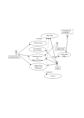
Two other UML tools were used to help clarify the process and to help in the development of the application. One of these was the activity diagram. The activity diagram depicts the sequencing and state of various parts of the process. It is good for showing conditional behavior, such as what happens if somebody makes a change to the digging request. Finally, a set of 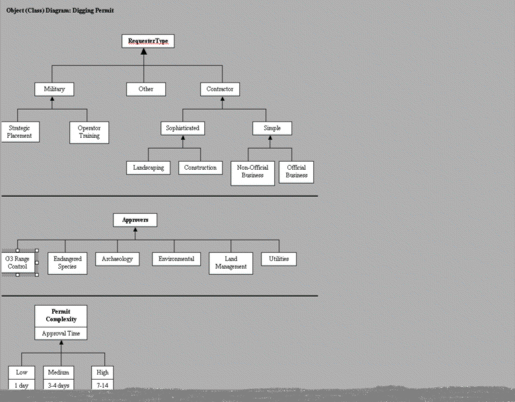
object class diagrams served to illustrate the composition of the types of requesters, the types of approvers and the relative difficulty of getting a permit through the process. Based on the analysis of the digging permit process, a set of goals for the application were developed
1.	Requestors, including those off-site, need easy access to the system where the request is made.
2.	As much information as possible about free dig areas, TES habitat, vegetation, cultural sites,
	and facilities should be provided to the requestor.  This would enable the requestor to make adjustments before,
	rather than after the fact.
3.	The requester needs to be able to draw the location for the activity digitally, so that the paper map
	is eliminated from the first part of the process.
4.	The map provided by the requestor needs to be as unambiguous as possible and drawn in reference to
	the same maps that are used to evaluate the request.
5.	A digital copy of the form needs to accompany the map.
6.	An automated overlay procedure needs to occur to allow the requestor an opportunity to review
	the potential issues in getting the request approved.
	At this point, the requestor may choose to move the location, rather than trying to do work in a sensitive area.
7.	The request must be delivered to the reviewers through electronic means.
8.	The order of the review needs to be tailored to the type of request so that the reviewers
	with the greatest likelihood of conflict review the request first.
9.	Some control must be implemented to ensure that the approval needed by an office is done only by that office.
10.	If the activity location needs to be changed, any completed reviews need to be redone.
11.	The fully reviewed material needs to be sent to the approving office for final approvaland printing.
12.	The requestor needs to be given notice that the request has been filled and be given an
	opportunity to print the completed materials.
The prototype system builds on the DER to allow a user to enter information on a map and to send the request to a set of approvers. The order in which the approvers receive the request is dependent on the type of request. A demonstration of this application is available at the 2001 Esri User conference. A more robust version of the application will be developed over the next year.
Conclusions
Consdirable effort was put into the use of a more formalized process to determine the busines process in question. In addition to the use case diagram, a set of object class digrams and an activity diagram were developed. It is not yet clear that the time spent on the development of such diagrams resulted in a better end product. The application users tended to see the process as much simpler and to illustrate it in a more linear fashion than what the fuller analysis revealed. In addition, they did not always have the time or inclination to interpret and react to the diagrams in their more complex form. It was clear from this exercise that more than one person in an organization needs to adopt the UML mode of documentation and communication in order for it to be effective. Our own organizations have not made a clear commitment to that. It was also found that communication with users is still more of an art than a science. Some simplified form of the UML digrams needs to be used with many users. The application prototype has had only a limited demonstration and review at the time this paper was written. The next stage of the project is a fuller development of the application based on user response.
References and Acknowledgements
Fowler, Martin. 2000. UML Distilled: a brief guide to the standard object modeling lanaguage. USA: Addison Wesley Longman, Inc.
Goran, William D., Jeffery P. Holland, John W. Barko, and Andrew J. Bruzewicz , Technical Report, 01 Jun 1999, U.S. Army, Corps of Engineers, CERL, Champaign, IL, Report Number 99/60, ADANumber 366731.
Ruiz, Marilyn, Dawn Morrison, David Bouwman, Kevin McNinch, Frank Schreiner, and Shari Forbes, Technical Report, 05 May 2001, U.S. Army, Corps of Engineers, CERL, Champaign, IL, Report Number 01/46.
The authors thank the staff at Fort Hood, Texas, for their time spent in interviews and answering questions about the digging permit process.
Marilyn Ruiz
Dawn Morrison
ERDC-CERL
Champaign, Illinois
Gary Smith
Ram Sheeri
Sam Houston State University
Huntsville, Texas