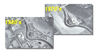
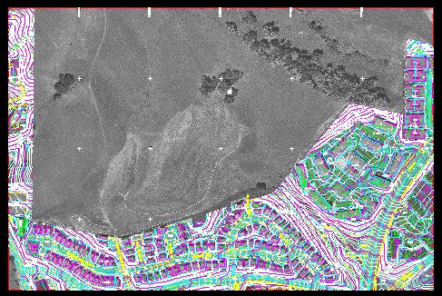
Figure 1 Ten year difference in Imagery
How Mapping Updates Are Vital to Local Governments' Management of Rapid Growth
by Bill Zeman
Manager, Consulting and Development Services,
Northwestern United States
HJW Geospatial, Inc.
510.638.6122
zeman@hjw.com
Many local governments throughout the southwest are contending with land use and service management issues caused by rapid residential and commercial development. One of their prime challenges is maintaining an accurate and useful GIS to provide effective services for the community. HJW Geospatial (HJW), Inc. is an aerial photography and digital mapping firm that works with numerous city and county governments to maintain accurate base-maps for their GIS via regular periodic mapping updates.
This paper will focus on the value of updating existing orthophotography using Esri software. I will address the process of mapping updates, the costs, direct applications and added value to growth management that this kind of project provides to local governments.
In this era of booming residential and commercial development it's critical to have up to date land data in making responsible municipal planning decisions. An accurate Geographic Information System (GIS) is probably your most useful tool for keeping track of the constantly changing environment. I am going to talk today about the value of maintaining a current GIS and the intrinsic importance that a high quality and accurate base map comprised of orthophotography plays in that undertaking.
As a former project manager, I have managed numerous large-scale orthophotography projects as well as several updates of those projects. The processes of initial mapping and updating are essentially the same and both require new controlled aerial photography to ensure the success of the projects.
By definition, the value of updating a base map is for increased accuracy; therefore new imagery is critical. The acquisition of new aerial photography allows you to look at current information such as changes in buildings, pavement legends, striping and many other features that would be very expensive to collect photogrammetrically, but are readily available in the updated imagery.
Figure 1 Ten year difference in Imagery
Due to technological advances, particularly improvements in compression algorithms, it is now possible to obtain much higher resolution data than might have been feasible in original mapping projects. This compression technology allows you to compress data sets with little or no loss of resolution, which results in easier display for use on the Internet or Intranet. It is also more economical and practical to store large raster data sets now than it was even five years ago. Data can now be delivered on hard drives for easy access instead of on tens or hundreds of CDs, as in the past.
New terrain data can also be derived from the newly controlled photography and enable you to either update terrain that has changed or add terrain data to its foundation. This updated terrain model is not only necessary for the processing of new orthophoto imagery, but is also important for other uses such as watershed modeling, creating profiles and creation of contour data.
Another added value that new controlled imagery delivers is the collection of accurate planimetric features such as buildings, street centerlines and road edges. Parcel data sets can be adjusted to the centerlines producing an accurate geospatial piece of information that can be readily available to various agencies within your city or county.
The procedures necessary to update an existing basemap are relatively the same as those to produce the original project. Initial base map projects require ground control, aerial photography, aerotriangulation, compilation and orthorectification. The update process involves the same steps, but some of the original data may be usable and serve as a cost savings. Original digital terrain model needs to be updated, but not entirely re-compiled. I will outline the general course of action for an updating project.
One of the key elements in the process is to make an analytical determination of the areas of change within your city or county. By comparing old photography against new photography an experienced technician can determine major areas of change. There are also sophisticated image correlation routines that can work as well. In some cases information already exists in the form of permits or planning maps that can aid in the process.
In general, the original ground control can be paneled and re-used for updating as long as your original project specified permanent ground control or at least temporary benchmarks. It is fairly simple then to panel the necessary benchmarks and add any panels for new areas prior to the aerial flight. The only survey work necessary in this scenario will be surveying coordinates for panels in new areas or for replacing original benchmarks that may have been destroyed.
Depending on the scale of the project, Airborne GPS technology can be used instead of all of the original control. For example the City of San Francisco Orthophoto original project required a total of 40+ ground control points, but the update project in conjunction with Airborne GPS technology required re-paneling only 10 of the original points. This amounted to an approximately 75% reduction in the surveying cost for the project.
The single most important step in the update process is the acquisition of aerial photography. If your original project was flown using flight navigation software it is easy to recover the Lat/Long coordinates of the original flight and use that. If new areas are added then certain flight lines will need to be added or some flight lines might need to be lengthened to cover those areas.
Figure 1 Digital Flight map
The next process is the addition of supplemental control to the previously targeted ground control. Softcopy Aerotriangulation, (Soft AT), is a routine Fully Analytical Aerial Triangulation photogrammetric procedure for establishing additional control points without the need for additional ground surveys. It densifies the targeted ground control and acts as a check on the ground control measurements. The aerial film is scanned and digital imagery is produced. These digital images and the GPS ground control data are loaded onto a digital photogrammetric workstation. The individual images are brought up to measure the fiducials and the interior orientation is computed. The system automatically selects and measures all of the passpoints and tiepoints on all of the images upon which they appear. This step can be performed in a semiautomatic mode where the operator interactively assists in the selection process; under some conditions, this is the more efficient method. The relative orientation is computed and will show all residuals on the passpoints and tiepoints. Any residual that exceeds the predetermined limit will be automatically "flagged" and will be revisited and manually corrected.
During the aerotriangulation process, the system will read the GPS ground control data, which resides on the system. This data, along with the results of the relative orientation and the ground control data, will be used to compute the final bundle adjustment for a given block of images. The final output from the bundle adjustment will include all the parameters necessary to set up an analytical or softcopy stereo instrument. The analytical instruments have special software that enables them to be set up automatically from the orientation parameters.
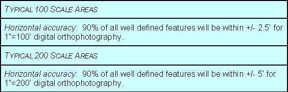
A digital terrain model (DTM) is also collected from the stereo photography to be used for ortho generation. The DTM is comprised of break lines which delineate various terrain defining features, such as ravines, ridges, tops and toes of slopes, as well as mass points which are used in flatter areas. Correctly processed DTMs meet all National Map Accuracy Standards specified in the Map Feature Accuracy section below.
To correct an aerial photo for distortion caused by terrain, a digital terrain model (DTM) must be included in the ortho processing. The DTM is collected by using analytical stereo plotters. Appropriate DTM 'patches' are collected to indicate motor vehicle bridges and overpasses. OrthoView, HJW GeoSpatial's proprietary software has a unique module that removes distortion that often occurs with elevated structures. For this process to function correctly, stereo compilers create patches, or mini-DTMs, of selected overpasses. These patches are then used in the ortho-processing to correctly align the bridges.
Control from the aerotriangulation and ground survey is used to tie the digital images to actual ground coordinates. The DTM collected from the stereo photography is referenced during the digital ortho-rectification process to adjust each image pixel into its correct position. The software allows for batch processing of the images, which results in a more timely final delivery schedule.
Many factors add to the costs of updating base maps. The amount of new development within the limits of the basemap affects the level of effort necessary to collect new planimetric features or update the terrain model. If you decide to increase the pixel resolution from 1' to .25', or decide to get 40 scale instead of 100 scale orthophotos the costs can be higher than the original project. In general, the costs for updating can range from 40% of the original project to more than the original project depending on the factors that I just mentioned. To update a project with the same specifications as the first in an area of little or no change can be about 50-60% of the original project budget.
New technology such as IMU, LiDAR and digital cameras will reduce these costs even more in the future.
In the example below, The City of San Ramon had their imagery and vector data updated to reflect their rapid growth. Orthophoto tiles were filled out to the extents of the 2000' X 3000' unlike the original project in which the orthophotos were clipped at the City Limits.
Original Delivery (1995)
Update Delivery (2000)
The City of Salinas required updates to their orthophotography and NPDES Study. The original project was completed in 1996. New black and white (B/W) photography was acquired in conjunction with Airborne GPS; also, new multi-spectral imagery was collected in the spring of 2000. The terrain model was updated in areas of significant changes and new B/W orthophotography was produced. The new multi-spectral imagery was classified and rectified to the new B/W orthophotography and new permeable/impermeable data was delivered to the City. This new data can be used for municipal planning, transportation planning, police investigations and other GIS applications.
The City of Visalia is presently updating their orthophoto base from B/W to color. The original project was completed in 1995 and then updated in 1999. The 1999 update was done in B/W to match the original project. This year the City has decided to acquire new color photography and produce .5' pixel resolution color orthophotography. The reason the City decided on color was to add the value of color for presentation purposes within the City departments.
The original orthophotography for the City of San Francisco was acquired and produced in 1995. This year the City has decided to update their orthophotography. New B/W photography will be acquired in conjunction with Airborne GPS. The use of airborne GPS minimizes the amount of ground control necessary to control the 100 scale product. This particular mission will acquire and control a total of almost 300 images with only ten ground control points. Ten of the original 50 control points will be paneled and used to control this block of photography.
The stereomodels will be reset and checked for any significant changes in the digital terrain model. The imagery will also be checked for any changes that may have occurred in elevated structures such as overpasses and bridges. There have been significant changes to the waterfront from the addition of Pac Bell Park to the re-development of the Embarcadero Freeway.
It is vital to have a high quality and accurate foundation for your GIS needs. It is also important to keep that foundation up to date so that information derived is current and useful. New images contain changes in buildings, pavement legends, striping and many other features that would be very expensive to collect, but are readily available in the updated imagery. New terrain data can also be derived from the newly controlled photography and enable the agency to either update terrain that has change or add terrain data to its foundation. This updated terrain model is not only necessary for the processing of new orthophoto imagery, but is also important for other uses such as watershed modeling, planning and transportation analysis.
Local governments are contending with land use and service management issues caused by rapid residential and commercial development. One of their prime challenges is maintaining an accurate and useful GIS to provide effective services for the community. One strategy is updating their base maps because it makes cost effective sense to maintain accurate base-maps for their GIS via regular periodic mapping updates rather than having to reinvest in a whole new foundation ten or more years down the road.
Bill Zeman is Manager of Consulting and Development Services, Northwestern United States for HJW. He earned a M.S. in cartography and a B.S. in geography, both from the University of Wisconsin, Madison. Mr. Zeman's expertise in photogrammetry, digital imagery and GIS is the result of having managed photogrammetric projects throughout the United States for more than 15 years.
For HJW, Mr. Zeman has specialized in the management of large-scale municipal mapping projects, including for the City of San Francisco, City of Oakland, City of Visalia, City of Salinas and Contra Costa County, to name just a few.