In order to improve the making Multicriteria Decision, we can have designed, a Multicriteria Evaluation Module that can be integrated like extension (AvEMC) into ArcView software. This module counts with several methods in order to classify and discover new mine deposits based on Cluster Analysis, Similitude Gower Coefficient and Heuristic Methods. The main purpose of this extension is to work with qualitative, quantitative and dichotomy attributes and incomplete information for developing a Decision Support System into Geographical Information System.
KEY WORDS: GIS, DSS, SDMSS, Geocomputation, TOPSIS, Gower, Ranks
Nowadays, Geographical Information Systems (GIS) are powerful and useful tools as means of information, visualization and research or like making decisions tools. One of benefits that the society has obtained by the development of these kind of systems, is that those applications can be used in order to assist in the making decisions; this kind of assisting would be visual or automatic ways, it has developed new research lines for integrating Decision Support Systems (DSS) and Geographical Information Systems, therefore they end up being of great
The capacity of the Geographical Information Systems, in order to generate a set of alternatives for taking and making decisions, is based on spatial relationships like the connectivity, proximity, adjacent and overlay. The main problem for using GIS in this way, it is presented around the decisions, that is how to incorporate the preferences of people that make them in this process. That is why GIS has very limited capacities in order to integrate these preferences.
The making decisions is defined for including any option or selection about the alternatives in action, therefore it is very important in several fields, like Natural and Social Sciences, including the Geographical Information Sciences (Geocomputation).
The kind of problems about the decision model a problem of real World, generally involucrate a great set of alternatives with multiples conflicts subjective and criteria of evaluation. These alternatives are generally are evaluated by a reduced group of people, who establish their preferences in respect to the relative importance of their criteria, it would imply to become subjective solutions. Therefore, GIS has been tried to be integrated base on making Multicriteria Decision.
A GIS can be designed for many purposes and different scales in order to represent the spatial data. It depends on its general functional schema, the duties of analysis subsystem, its implementation, the types of analysis to considerer and the accuracy of calculates and results.
Making decision is a process that involves a sequence of activities that starting with a decision in a recognition problem and finishing with recommendations. The present work tries to provide an alternative about how to use GIS as classified tools in order to make a decision in a mining exploration.
A system of this type is a special tool that can be used in order to plan and administer natural and social resources, in a regional level or scales with more detail. This kind of systems has the capacity of answering specific questions based on the combination of two fundamental elements:
1. A database that claims different georreferenced layers (inside GIS).
2. One or more simulation models that integrate different information layers, making calculus and providing results based on the necessities of the users. These models can change in their complexity, but they permit to approach the database and to relate the information that exist.
In order to develop a prototype of DSS; a special Module of Multicriteria Evaluation can be programmed and it can be integrated into commercial GIS. This module contains algorithms in order to work with attribute tables that are associated to thematic layers; especially for qualitative attributes, because in the majority of the cases the information that is available in the databases into GIS, is incomplete and they show the characteristics of the object that describe and sometimes contain much subjective information about the observations made last time.
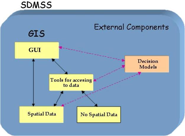
The figure No. 1, shows the general schema about of Spatial Decision Multicriteria Support System (SDMSS). The prototype consists on GIS that interacts with an external module. The GIS provides a sophisticated interface for the spatial data, besides, it permits to make operations on the geographic elements.
Figure No. 1. General Diagram of Spatial Decision Multicriteria Support System.
A GIS has its own DBMS that permits to link the interface and the database in order to offer the users to make spatial queries. Although GIS has certain limitations so that it can work as Decision Support System; through extern components, we can add the models that permit to generate the decisor center with the evaluation criteria so that it can develop alternative series that shows a solution.
The extern component was added like a extension to ArcView its name is AvEMC that operates as making decision tool, especially for the qualitative and dichotomy attributes.
The functionality of GIS can be subdivided in four subsystems: Input, Administration-Storage,Analysis-Management and Data Output. Each one of these elements has functions that permit the operation of GIS, besides, they provide the capacity in order to obtain data for making decisions. The Analysis-Data Management Subsystem counts with the capacity for integrating the analysis about spatial data and attributes, but nowadays we can have the ability for adding new external models that increment the analysis types that can make a GIS. These modules compensate the limits that GIS has in the structure analysis in order to improve the decision models.
For the data in a GIS can be analyzed and managed into the each subsystem, the modules that have the basic functions, the spatial analysis tools must interact together in order to manage and analyze the spatial data and attributes, trough new functions we can work with data that storage in the database for adding mathematical models for making decisions, like this case with AvEMC Extension.
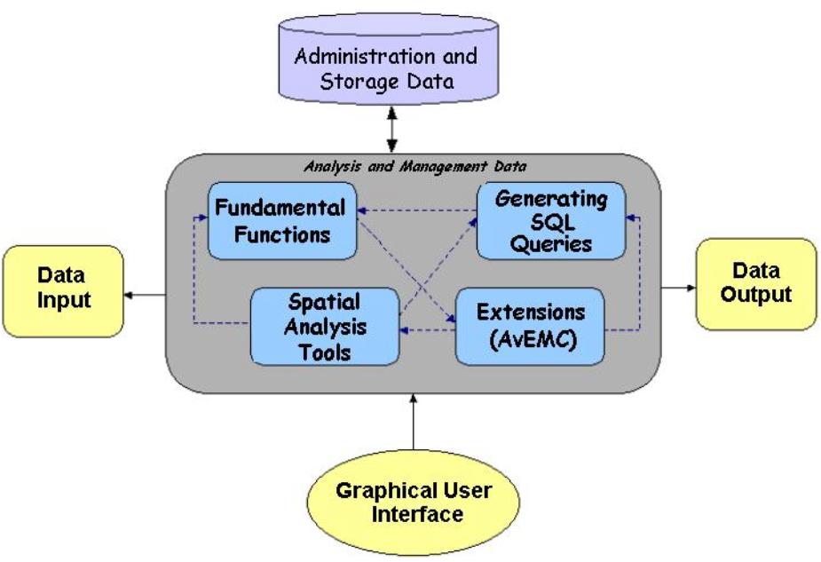
Figure No. 2. Architecture of GIS with Multicriteria Evaluation Model.
As a conclusion, this kind of tool permits to generate digital decision maps through the combination of several decision models, that involucrate Heuristics Classification Methods of any attribute type, especially the qualitative types. This technique is not commonly used in these kind of tools. The system developed can be considered a Decision Multicriteria Support System (DMSS).
The methods implemented inside AvEMC extension work with any type of attribute: qualitative, quantitative and dichotomy. This extension is available to work with incomplete information, the algorithms designed and developed were TOPSIS, Ranks, Cluster Analysis and Similitude Gower Coeficient.
The TOPSIS and Rank methods permit to assign weights depending on the importance of the attributes, locating them inside of rank, in other way, each criteria is categorized in the preference of decisor center (priorities). Once we established these ranges, we need to select three methods for classifying basing on their importance:
Ranges Sum. Weights that are calculated and formulated based on the next equation:
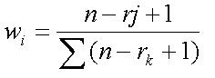
Figure No. 3. Equation for ranges sum.
wi Normalized weigth for j... criteria
n Number of criteria to consider (k=1,2,…,n )
rj Position of range inside the criteria
Reciprocal Ranges. Weights are derived of normalization of reciprocal values of criteria. The next equation is used in order to calculate the weights:
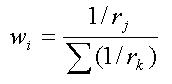
Figure No. 4. Equation for reciprocal ranges.
Exponential Ranges. Values that are inside the scale between 0 and 1, these weights are calculated with the next equation:
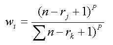
Figure No. 5. Equation for exponential ranges.
The last method has a drawback, because it is necessary to add a field for the weights to attributes.
The spatial objects classification is very important, because it reduces the number of spaces, forming groups with a special and common characteristic, with this way we can establish a typology where it is wished to remark these common patterns in the top to spatial objects. Besides the defined objects are similar, and present spatial contiguity or adjacency. We can speak about “Regionalization” or a set of elements in areas with spatial adjacency.
The model for qualitative data combines two techniques: Cluster Analysis and Similitude Gower Coefficient, both classify the attributes in groups with the same characteristic, with this model; we can make a classification and generate the Voronoi Diagrams in order to show the Regionalization.
The figure No. 6 shows the model of Regionalization generated by AvEMC. This is important to mention to be able to develop the Thiessen Polygons or Voronoi Diagrams; we need the elements present a special topological structure, in this case points and using the maps overlay we will take the criteria to consider.
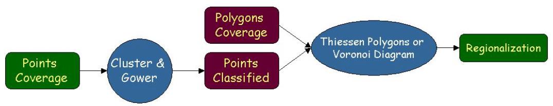
Figure No. 6. Modeling of process in order to generate the Regionalization of punctual elements.
After defining the qualitative variables for the process, we need to define the observational matrix, where the distance between the objects is calculated. A metric in order to calculate the proportion of distance between 2 objects i,j is denoted by the expression:
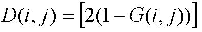
Figure No. 7. Equation for Gower Distance.
D(i,j) It is the value that can characterize the similitude between i and j by the Euclidean distance, named Gower Distance, then i and j will have a strong similitude, while the distance is small.
This methodology has been experimented in the classification of lands depending on natural conditions in order to develop social and economics activities [Candeaux, Novua & Diaz, 1989]. The figure No. 8 shows this kind of classification trough Cluster Analysis using Gower Distance.
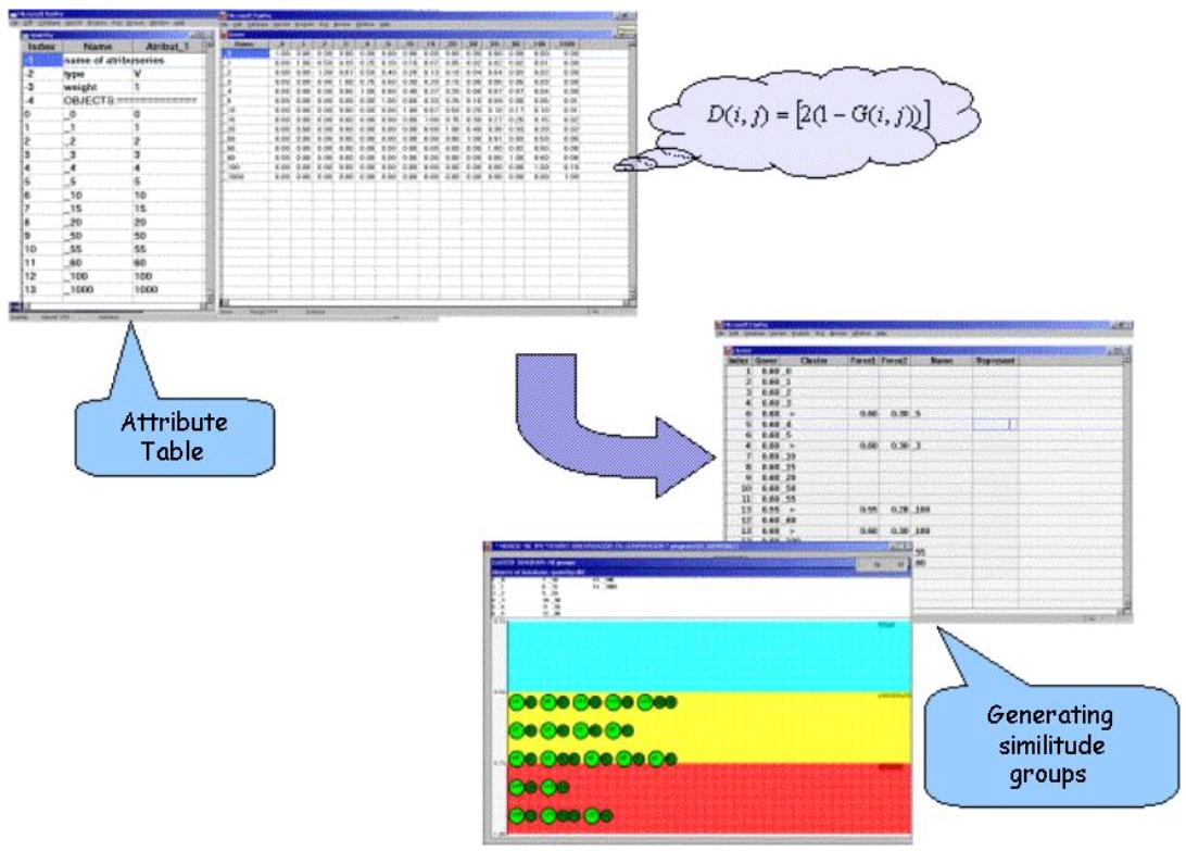
Figure No. 8. Attributes classified by Cluster Analysis.
Using these methods, we can develop or generate digital maps with qualitative attributes, according to weights that were added to the criteria; besides it is necessary to use a combination to TOPSIS method for generating the Ranks. In other case, for the qualitative and dichotomy attributes, those are created with Cluster Analysis using Gower Distance and interpolating the points we can create a digital decision map that shows interest areas. In the figure No. 9 we can show types of analysis made for the AvEMC Extension.
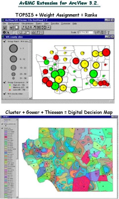
Figure No. 9. Types of Analysis made for AvEMC Extension.
A practical example can be used in order to find mine deposits using known criteria, deposits and the environment around them. Like geology, drainage density and fracture density. Those permit to create areas based on characteristics of deposits, that have a higher probability of containing other minerals.
By using a Voronoi Diagrams, the mines, that are represented by punctual symbols, permit to delimit areas through classification to contained mineral, considering the geology overlay in order to delimit areas with a higher probability that contain similar deposits, besides we need to consider the last criteria (geology, drainage density and fracture density). See the Figure No. 10.
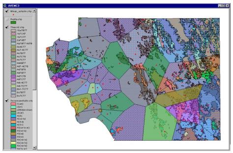
Figure No. 10. Creating areas through geology criteria-deposits.
In the figure No. 11, we show the classification of mine deposits considering the fracture density, although the digital map is similar, it presents some difference, because when the Thiessen Polygons were done, they consider the down area and present a different fracture density and the points are contained in the same geology part.
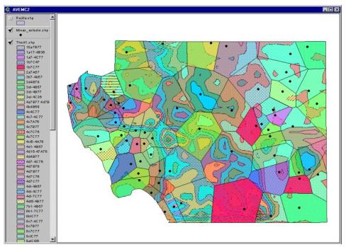
Figure No. 11. Creating areas through fracture density criteria-deposits.
These kind of research areas: GIS and Multicriteria Decision Making take benefits from each other, the GIS technology has an important roll in the analysis of problems about Multicriteria Decision Making, because it offers unique capacities for automatic managing and analysis of spatial data for the making decisions. On the other hand, the Multicriteria Decision Making and the great variety of methodologies related with techniques and procedures, achieve to improve the model which makes a special decision and can be incorporated into GIS.
Both techniques are very important in the analysis problem in order to find better solutions, because the Multicriteria Decision offers capacities for the automatization, administration and Analysis of spatial data in order to make a decision and provides other methodologies related with it. Like making multiobjective decision, making multiattributes decision and making collaborative decision, these techniques or procedures can be added to GIS based on making decisions.
The most important topic about the work is related to the implementation of several multicriteria evaluation methods into the AvEMC extension, ready to use in ArcView, and it can be operated as others in the same way, providing special techniques in the developing spatial analysis based on Multicriteria techniques.
Barredo José. (1996). Sistemas de Información Geográfica y Evaluación Multicriterio en la ordenación del territorio. Editorial RA-MA, Madrid.
Romero Carlos. (1993). Teoría de la decisión multicriterio: Conceptos, técnicas y aplicaciones. Alianza Editorial. Madrid.
Jankowski J. (1995) Integrating geographical information system and multiple criteria decision - making methods, Int Jou. Of Geographical Information Systems, vol 9, No. 3, 251-273
Carver S. (1991) Integrating multicriteria evaluation with geographical information systems, Int. Journal of Geographical Information Systems, vol. 5, No.3, 321-339.
Díaz C. Sistemas de Información Geográfica. Universidad Autónoma del Estado de México.
Sreedhar Sundaram. Visual Interaction Modeling Of Multiple Criteria Group Decision Support Systems. Universidad de Wisconsin-Milwaukee
Taha Hamdy A. (1995). Investigación de Operaciones. 5Ş. Edición. Editorial Alfaomega. México.
Esri (2000). ArcView Dialog Designer. Environmental Systems Research Institute Inc.
Esri (2000). ArcView Spatial Analyst. Environmental Systems Research Institute Inc.
Esri (2000) ModelBuilder. Environmental Systems Research Institute Inc.
Esri (1997) Avenue. Environmental Systems Research Institute Inc.
Jankowski J. (1995) GIS an Multicriteria Decision Analysis. Editorial Sons. Canada.
McKinney Daene, Ximing Cai, Maidment David. A prototype GIS base decision support systems for river basin management. gis.Esri.com/library/userconf/proc97/proc97/to200/pap164/p164.htm
Enache Mircea. Integrating GIS with DSS: A research agenda.
Stevens David and Dr. Derek Thompson. GIS a Social Practice: Considerations for a Developing Country. www.david.stevens.net/gisdecmk.htm
Tkach Robert. A new approach multicriteria decision making in water resources.Journal of geographic information and decision systems.
Batty Michael, Densham Paul (1996). Decision Suport, GIS and Urban Planning. London.
Amorós Zavala Evaluz Citlalli, Centro de Investigación en Computación, Instituto Politécnico Nacional, México, D.F., 2001 “Módulo de Evaluación Multicriterio para SIG aplicado a Ciencias Naturales”. Tesís de Maestría en Ciencias de la Computación.