Rob Noble
Techni Graphic Systems, Inc. (TGS) has developed a software program, called PlotFinder, in cooperation with prominent cemetery professionals. PlotFinder is designed to help cemeteries manage burial and plot sales information with a user-friendly map interface in a Windows environment.
TGS developed PlotFinder using the Esri MapObjects v. 2.0 control, Microsoft Visual Basic programming language, and Oracle database technology. The entire cemetery industry has the opportunity to enhance its business practices by embracing this interactive product. Instant access to sales and burial records, combined with user-friendly interfaces, will greatly increase productivity and customer satisfaction
TGS is dedicated to providing quality custom software and services in the field of Visual Information Systems. The unique ability to provide powerful applications with customer-specified interfaces, along with data conversion services and database design and support, allows TGS to successfully implement complex solutions. Go to www.tgstech.com or www.plotfindergis.com for more information.
Cemeteries have traditionally maintained all owner and burial information in ledger books, on note cards and on paper maps. Most cemeteries continue to rely on these antiquated paper documents as their sole source of burial and location information. Searching these documents can be extremely time consuming. In addition, these documents are subject to loss and destruction, compounding the difficulties with the data retrieval process. The inability to quickly retrieve accurate sales and burial information can be quite costly.
TGS has developed PlotFinder to help cemeteries easily retrieve and manage burial and plot sales information with a user-friendly map interface in a Windows environment. PlotFinder combines the power of a Geographic Information System (GIS) and the latest Windows technology. It utilizes a user-friendly dynamic map interface running on the Windows platform to give the user textual, numeric and location-based visual information. TGS developed the map interface for PlotFinder using the Esri MapObjects control within Visual Basic code. TGS developed Spring Grove’s PlotFinder to interact with their Oracle database. TGS has since developed a more generic PlotFinder to interact with any ODBC-compliant database.
TGS believes the entire cemetery industry can greatly enhance its business practices by embracing this interactive product. Instant access to sales and burial records, combined with user-friendly interfaces, will increase productivity and customer satisfaction.
TGS originally developed PlotFinder as part of a massive data rescue effort for Spring Grove Cemetery and Arboretum in Cincinnati, Ohio. Like many cemeteries, Spring Grove maintains much of its information as paper records. Many of these paper records are deteriorating with age. In Spring Grove's case, some documents are over 100 years old. In addition to its paper records, Spring Grove maintains 20 years worth of data in an Oracle database.
The goal of the data rescue effort was to capture all of the paper records electronically, including maps, for archival purposes and add them to the Oracle database. TGS programmers developed PlotFinder as the Graphic User Interface (GUI) for retrieving all scanned documents, burial information, plot owner information and locational information.
TGS developers worked closely with Spring Grove’s representatives to develop a custom GIS program that would meet their needs. The initial requirements of the PlotFinder interface included:
TGS has successfully implemented PlotFinder at Spring Grove Cemetery. TGS continues to make enhancements to PlotFinder and has implemented a custom version of PlotFinder at a number of cemeteries both large and small.
Spring Grove contracted Techni Graphic Systems to perform all data rescue activities. As part of this effort, TGS scanned over 250,000 paper documents and maps. TGS incorporated document imaging within PlotFinder. These scanned documents are linked to the appropriate burial and owner information in the Oracle database. The tiff image of each document can be viewed within PlotFinder.
Additional data entry was also performed by TGS. Burial and owner information taken from the scanned images of the index cards and lot books was added to the existing database. Spring Grove’s database now contains information on every interment in the cemetery.
All maps were digitized and coded in ArcInfo. Linework was captured from AutoCAD files, paper maps and lot diagram books to create Arc/Info shape files for the Oracle database. The AutoCAD files were opened and exported as .dxf files. They were then converted to Arc/Info coverages on which the linework was edited. The paper maps were scanned saved as .tif files. The linework was then drawn right on top of the image.
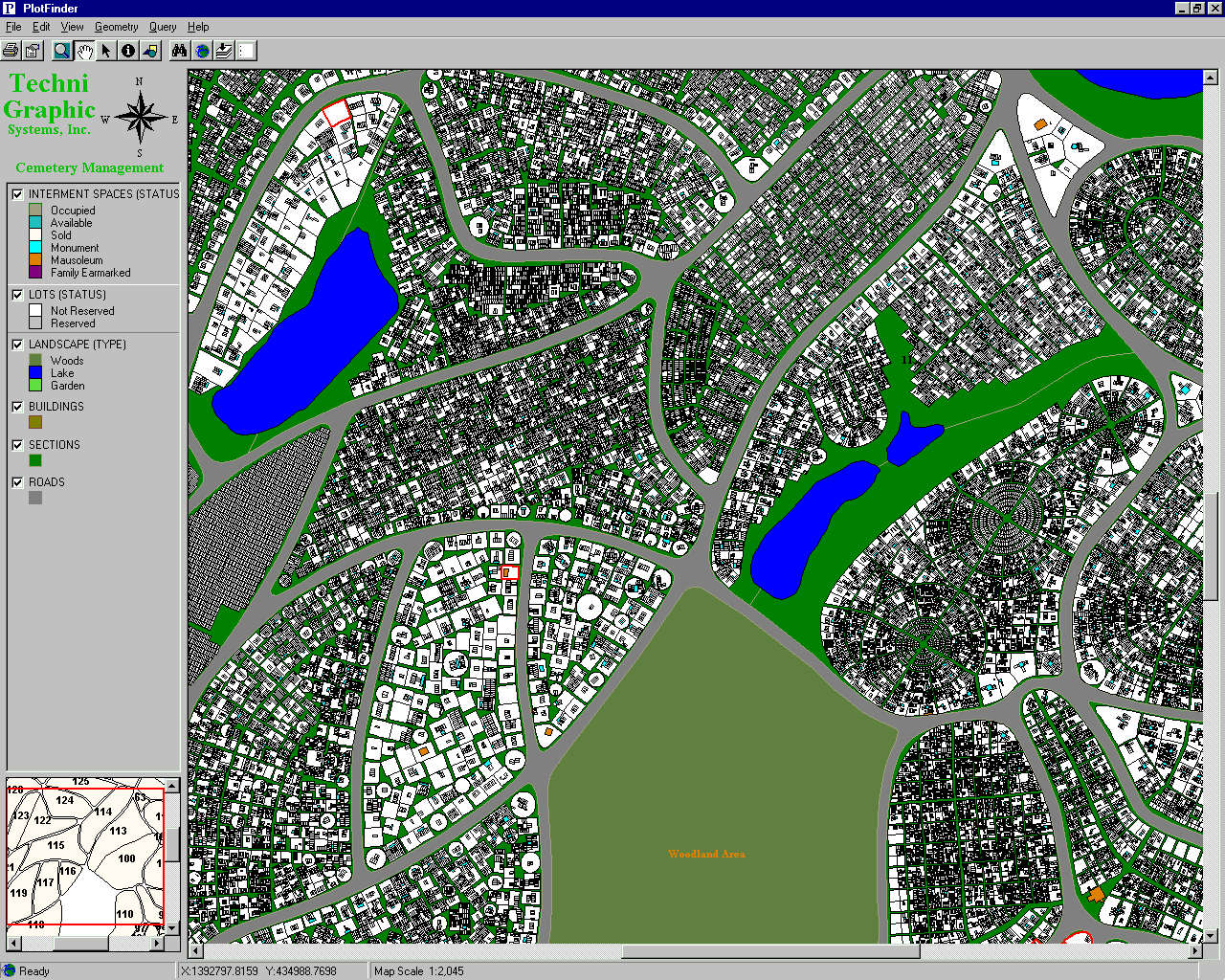
The cemetery consists of hundreds of individual maps. All maps were appended together as a seamless coverage and inserted into a plan view of the entire site (figure 1).
FIGURE 1. Example of the PlotFinder map interface showing the appended coverage.
Once the linework was captured and cleaned, the coverage was built using the polygon option. This creates individual polygons that can be coded with information invfields such as a cemetery’s section, lot and space number. Each space was coded with a unique identifier and linked to the appropriate burial and owner information in the Oracle database.
PlotFinder enables cemetery personnel to retrieve burial and sales information quickly and easily. Enhanced functionality includes:
PlotFinder is a unique example of a specialty software solution developed by Techni Graphic Systems to help an industry "visualize its business". TGS is continuously searching for unique vertical markets that require a full array of goods and services designed to make information visually accessible.
Rob Noble
Business Development Manager
Techni Graphic Systems, Inc.
2301 Research Blvd, Suite 101
Fort Collins, CO 80525
Phone: (970) 224-4996
Fax: (970) 224-3001
robn@tgstech.com
www.tgstech.com
www.plotfindergis.com