This paper presents how ArcIMS can become a powerful tool for city Planning, growth organizing and giving the citizens an easy way to reach Information about city land use restrictions.
In the second semester of year 2000 Bogotá´s city council approved a new law which regulates the development of the capital, this law is also known as POT. Iit includes urban guidelines such as: how many floors a building can have or what kind of business can be open in a neighborhood or where is the government planning to build a new highway etc.
The main objective of this project is to allow the citizens to access, consult and understand the POT through a web site which includes maps and tabular information as a real GIS site.
Terms like information democratization, clering-houses, networks of digital geographic information and e-government are more and more often mentioned in conferences, meetings and work places. However, many of us ignore that the realization of projects which involve these concepts require a strong institutional commitment and a great technological challenge.
In the second semester of 2000 a project team of PROSIS S.A, in conjunction with the DAPD system office, finished successfully a project named SINU-POT (Urban Norm Information System ) One of the first Internet Sites supported by ArcIMS Technology and designed to allow geographic queries about urban rules and use land restrictions. This system will help the information distribution process, improving the general knowledge of the citizens about the new rules that delimit the city development.
Bogota is a Mega City with more than 7 million people, an area of about 1732 KM2, and a demographic grow rate of 150000 person per year(2.5%). Some places in the city have the demographic density of Manhattan and others do not even have utility networks like water or electricity. It is a city in a constant and accelerated growing.
In the first semester of 2000 the city major decreed a new law called POT which will rule the urban city development. This law include dispositions of many kinds like general land use restrictions, very particular land restrictions for small areas, maximum number of floors allowed in residential and business areas, delimitation of areas for environment conservation, routes for public transportation systems and many others.
All of these dispositions have a common aspect, which is the spatial or geographic component. For the citizens is not only important knowing how many pathways Bogota has. For them it is also important knowing if there is a pathway connecting the work place with home, and the best way to convey this kind of information is trough a map. It is also important state that the land restriction laws are not uniform in the entire city and as any big city of the world these rules could change as long as time passes.
Before the SINU implementations to find out which were the urban rules or the urbanistics projects in a specific area of the city could be an arduous job. That because all the documents and maps were in a hard copy format. As a consequence it were storage in a file with restricted access and many times the documents were not update. As a consequence of these situation jams and delays were common when some one tried to get this information.
The administrative department of city planing (DAPD) is the government institution on charge of the development and implementation of the new POT. To face this challenge the DAPD was looking for a tool with three main characteristics:
- The system should be able of manage and storage large volumes of information.
- The system should allow an easy data update.
- The system should bring a wide access to any user.
The answer to these requirements was the SINU-POT.
SINU-POT is an Information System, which allow access to any aspect of the Bogota urban legislation trough a web interface with geographic tools. It also storages all the information in a centralized way in a DataBase.
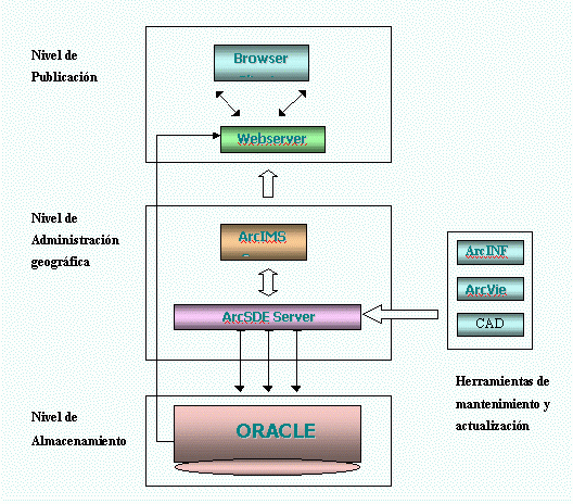
SINU-POT can be also described as a three levels system, the function of the first level is to storage information, the second level is on charge of the information management, and the last level publishes the information on the internet.
The storage level is built in an Oracle Database, this database keep all the information of the system, including vectorial features which are the maps foundation and all the tabular data that defines the urban norm of a specific area of the city.
The administration or management level is composed by ArcSDE , a Spatial database engine which allows keeping geographic information in a relational database, and ArcIMS an Esri software for the publication of geographic information on the Internet. The interaction between these two elements give the system the ability of getting information from the database (Geographical and tabular data) and put it on the web.
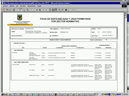
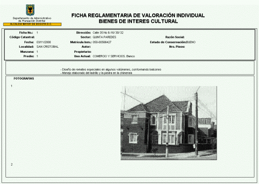
The publication level is made of a webserver which physically allows the transmission of the information, customized html pages of the ArcIMS html viewer, static html pages and the clients which access all the features of the system just using a web browser. The system also uses Oracle Internet Aplication Server to publish reports in “pdf” format based on tabular data stored in the database. These reports contain all the urban information about a specific city area. This information include rules like the maximum number of floors allowed, the specific land use for the area, and the demographic density among others.
The illustration below show the communications and relations between the three levels of the SINU-POT.
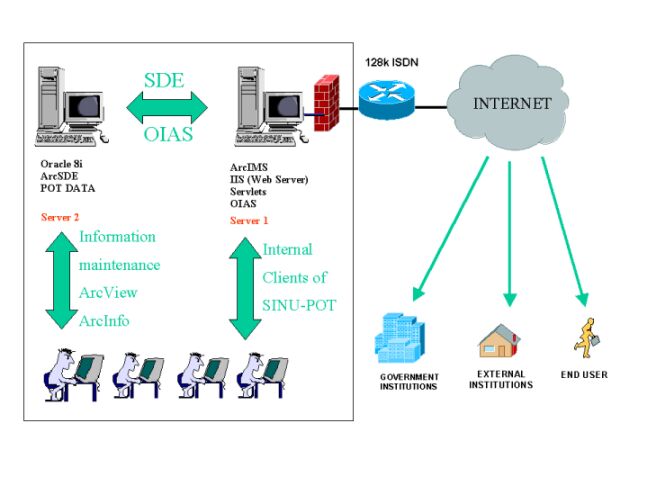
The SINU-POT is footing over a consistent collection of hardware and software. At the hardware level the system runs over two Nt 4.0 servers. One of them take care of the information storage, therefore in this server are installed ArcSDE 8.1 and the ORACLE database engine. The other server take care of the publishing operations, in this server are installed all the components of ArcIMS, the Web Server (the SINU-POT uses Microsoft Information Server as a WebServer ) , Oracle Internet Application Server 1.0.1 and the html pages which make up the front end of the system.
The next figure illustrates the distribution of the hardware and software components of the SINU-POT
Other way to describe the SINU-POT System is like a Web application wich allows the arranged publication in the Web of three types of data:
- Thematic maps.
- Urban Normativity
- Support Documents
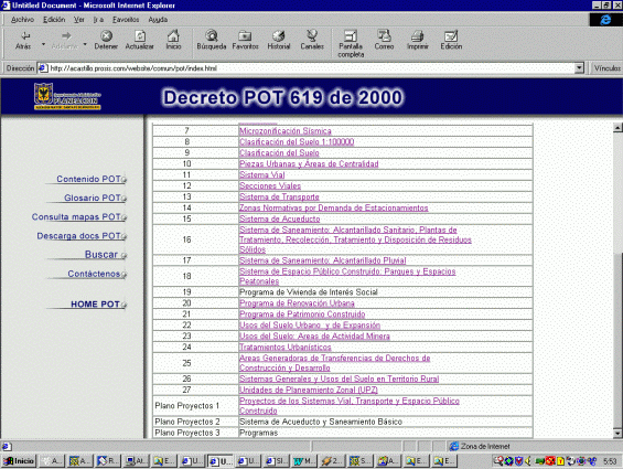
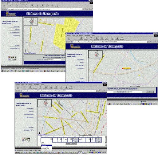
Through the SINU-POT the citizens and other clients like Construction offices or other government institutions can access thirty thematic maps which covers all the city area and a map which is the gate to consult the urban norms.
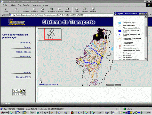
The thematic maps are about general information for all the city area like streets and main roads map, transportation infrastructure, utilities networks, environmental classification of the land, administrative boundaries, general land restrictions, parking demand zones, pathways, sismic microzonification, and future city projects.
Any map at any time can be printed from this interface in a custom layout.
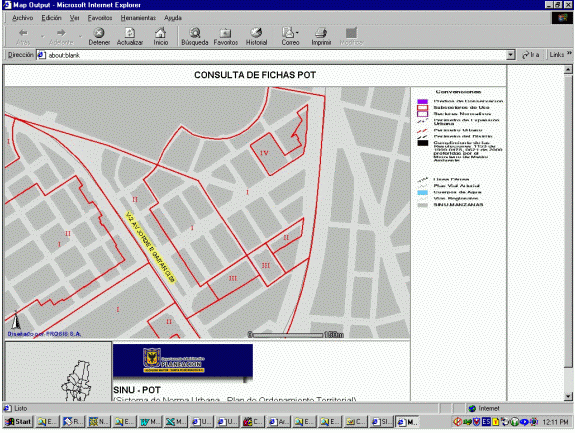
The urban norms are rules which define the use land restrictions and the building restrictions for a very specific zones of the city. At the SINU-POT this tabular information is storage in the database and is associated with polygons that can be visualized from the thematic maps. Each polygon defines the area of the city in which the norms apply.
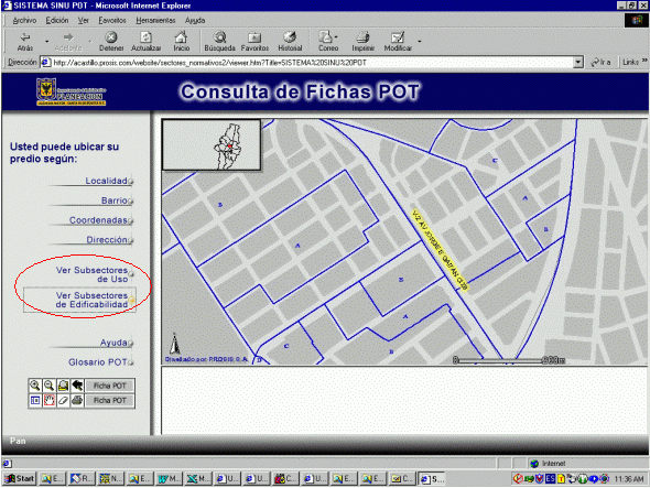
To reach the information the user must first locate the interest area, this can be accomplish trough the location tools (looking for an address, the name of a neighborhood, or a pair of coordinates) or zooming and panning trough the map. Once the user has locate the interest area, the user is one click far from information. He should click on the screen and the system will show a report in PDF format which include, a table with all the urban norms of the sector where the user clicked on.
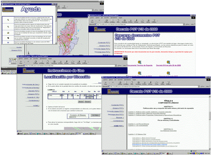
The third kinds of information published by the SINU-POT are the support documents or support pages. These are static html pages designed to make easier and more comfortable the navigation trough the site and to provide supplementary information to the user. These pages include a download zone, from which anybody can download a digital copy of the edicts associated with the urban norms. The system also include a help page, a page of instructions which show how to use the system, a page which allows an on line query to the POT document, a page with a glossary of terms, a page with links to associated websites, and a contact page to send an email to the system administrator.
-The SINU-POT was a successful project, developed on schedule, satisfying the user requirements. It was implemented by an interdisciplinary group of professionals.
-The SINU-POT helps to the development of the city because now the city planers and the general citizens count with a unified database with all the urban norms, and more important this information can be delivered free by the Internet.
-The SINU-POT improves the process in the DAPD reducing the time response for external and internal client requirements.
-The DAPD count with a unified geographic database, which will help in other planning process.
-For the implementation of a project of this type is important to have a strong institutional commitment because in general the government institutions are the information providers.
-Share information makes it worth more.
PROSIS SA would like to thanks to DAPD (The administrative department of city planing) and to any person from this institution wich colabórate with the implementation of this project.