Trisha Wildey Brush
The phenomenal boom in the myriad uses for Geographic Information Systems (GIS) within the last five to six years has resulted in a quality control problem. Many GIS data are of poor or questionable accuracy. Thus, there is an ongoing debate in GIS circles which focus upon whether or not GIS professionals should be certified. Part of the discussion includes the necessity for establishing GIS professional standards and GIS as a profession. Therefore, determining the importance of a certification program for GIS professionals is timely and relevant.
The phenomenal boom in the myriad uses for Geographic Information Systems (GIS) within the last ten years has resulted in a quality control problem. Many GIS data are of poor or questionable accuracy. (Goodchild and Kemp 45) Thus, there is an ongoing debate in GIS circles which focuses upon whether or not GIS professionals should be certified. Part of this discussion includes the necessity for establishing GIS professional standards and GIS as a profession. (Obermeyer, "Certifying" 67)
Technically speaking, according to Environmental Systems Research Institute (Esri, a GIS software company) GIS is "...an organized collection of computer hardware, software, geographic data, and personnel designed to efficiently capture, store, update, manipulate, analyze, and display all forms of geographically referenced information." (Esri, Understanding 18) GIS has been around for 30 years. It originated when a number of geographers devised a system for storing and organizing spatial information in a computer. Only over the past ten years has this growing technology come to be known as GIS. (Esri, Understanding i)
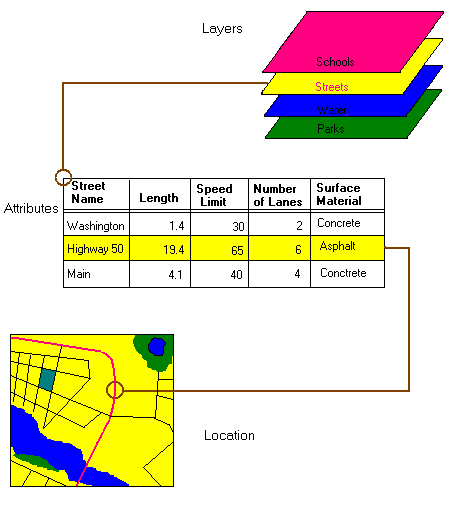
GIS utilizes mapping software which connects information about location with details regarding landmark attributes. (Esri, GIS 1) On paper maps, cities, roads, rivers, historic landmarks, parks, forests and other sites are indicated through wording and special icons. A GIS or digital (computer-produced) map will also have dots or points to represent locations such as cities and towns, lines to denote roads, small areas which could identify lakes, counties or other sites of interest. The difference between these two representations is that the GIS data comes from a database, whereas the map information originates from cartographers who manually design these reference materials.
The layers of data in a GIS map contain information such as highways, utilities, property lines, school districts, fire districts, land use, voting precincts and many others. "What layers of information you combine depends on your purpose-finding the best location for a new store, analyzing environmental damage, viewing similar crimes in a city to detect a pattern and so on." (Esri, GIS 1) At the base of the GIS is the layer which contains the horizontal and vertical coordinates which keep all the layers spatially correct. Spatial accuracy is the relation in which map data fit with real world coordinates.
Figure 1. Visual representation of layers, attributes, and geo-spatial location, David Davis, GIS for Everyone (Redlands, CA: Environmental Systems Research Institute, Inc., 1999) 28.
Recent advancements in this technology have resulted in the unprecedented growth of GIS applications. "From high-quality cartography to land use planning, natural resource management, environment assessment and planning, tax mapping, ecological research, emergency vehicle dispatch, demographic research, utilities, business applications and more, GIS promises to be one of the largest computer applications ever to emerge." (Esri, Understanding i)
There is tremendous interest in GIS today because it provides a means of collecting and utilizing information in a way which enables communities to understand and address some of the most urgent problems societies face today-"...tropical deforestation, acid rain, rapid urbanization, overpopulation, hunger, spread of disease and impacts from our global climate, to name a few." (Esri, Understanding i) GIS helps users worldwide "...to organize data about these problems and to understand their spatial relationships providing a basis for making more sensitive and intelligent decisions." (Esri, Understanding i)
The main purpose of this research study is to determine whether or not there should be a standard means for certifying the competency of Geographic Information Systems professionals.
This study was designed to gain insight from GIS professionals regarding their views on the necessity of GIS certification. Additionally, the academic research of this study focuses on the major issues of GIS certification.
In order to determine the importance of a GIS certification, the following questions must also be addressed:
Based upon these issues, the following hypotheses were developed:
Ho: GIS professionals perceive GIS to be a profession.
Ho: GIS professionals perceive that a certification process should be established in order to insure a higher level of competency among the GIS profession.
Ho: GIS professionals perceive that a certification process will improve their marketability.
Ho: GIS professionals perceive that certification will assure their quality of work.
A descriptive survey was designed to collect the primary data needed for this study. Secondary data were gathered from books, online libraries, trade magazines, professional journals and the Internet. This information will aid the reader in understanding other GIS professionals' views and insights on this subject.
The limitation of the primary data is that a random sample was selected from a private database consisting of members from the following professional organizations: Kansas Association of Mappers (KAM), Urban and Regional Information Systems Association (URISA), Mid-West Great Lakes Arc/Info Users Group (MWGLAIUG) and the Mid-America GIS Consortium (MAGIC). An assumption was made that the sampling used was representative of GIS professionals.
Due to the lack of scholarly journals in the field of GIS, much of the secondary data was obtained from trade periodicals and conference proceedings.
This study was designed to analyze the necessity for a GIS certification and to statistically determine GIS users' opinions on this current trend. The hypotheses were formulated due to the issue of certification being timely and relevant for the future growth and development of the GIS profession. (Albrecht 571) Undoubtedly, the resolution of this important issue will seriously impact the GIS world.
GIS has been in existence since the mid-1960s, and, while GIS has mushroomed into a huge field which is increasingly utilized in almost every global industry and governmental agency, the status of GIS itself has not progressed to a recognized level of professionalism. The reason for this disparity is that no professional standards have been established for GIS professionals and no accreditation for GIS educational programs exists. (Huxhold Slide 1)
The first step in recognizing professional expertise in GIS is the confirmation of GIS as a profession. (Goodchild and Kemp 45) According to D.L. Pugh's article, "Professionalism in Public Administration," there are six criteria which determine a particular field to be a profession. Below are the six criteria followed by either Yes or No as each criteria applies to GIS and also an explanation of how each Yes response describes the GIS industry currently. The criteria shown, in italics, are those cited by D.L. Pugh (2-3) and the explanations which follow each criteria are from William E. Huxhold. (Slide 8)
While the GIS industry does not satisfy each of Pugh's criteria for a profession, still it is obvious that GIS does not have that far to go. (Obermeyer, "Certifying" 69)
The second step in recognizing expertise in GIS technology is through certification, since it furnishes a means of evaluation. (Chamard 675) Certification is a hot topic in GIS circles as the use of GIS has increased considerably. (Burley 17) GIS organizations worldwide (ACSM, AGI, ASPRS, AURISA-Austral-Asian Urban and Regional Information Systems, ISO-International Organization for Standardization, UCGIS, URISA) recognize the need for certification. (Albrecht 571)
Certification and licensure have been in existence in some occupations for quite some time. Professions such as medicine, law, planning, surveying and cosmetology have long-established certification procedures. First, a distinction between the terms licensing and certification must be established. Licensing refers to an individual's legal right to perform an activity in the public arena. For example, a driver's license gives an individual the legal right to operate a motor vehicle. Licensing is administered by a governmental body or department which in turn is most often regulated on the state level. Certification is a program which usually involves one's peers in a professional association or society attesting to an individual's competence in an area of specialty. Generally speaking, certification is usually voluntary, but it enhances an individual's professional credentials. (Schuckman 58) Certification is the process under discussion in this thesis.
Investigating some of the successes and failures of historical licensure and certification processes will aid in providing the guidelines needed to design a GIS certification. The American Medical Association's requirement that all doctors be licensed by the state, as well as have a medical degree, has resulted in the AMA being "...one of the most successful organizations in the United States." (Obermeyer, "Certifying" 69) In contrast, the American Institute of Certified Planners (AICP) has declared that certification of its members is voluntary and, thus, few become licensed. "Without some mechanism (either voluntary or coercive) to limit entry into planning practice exclusively to AICP members, it is virtually impossible to assure quality across the board within the planning profession." (Obermeyer, "Certifying" 70)
Mainly, land surveyors are the professionals who are actively promoting the certification issue. "One of the major driving forces behind the certification initiative is the efforts among the surveyors to have state legislatures pass the Brooks Law, which would require that anyone who uses a GIS in a way that would affect base maps (and registration points specifically) to be licensed as a surveyor." (Obermeyer, "Response" 10) According to Joshua Greenfield of the New Jersey Institute of Technology, California, for example, has decreed through legislation that surveyors must collaborate in land projects which involve GIS. (Somers 29) "The time has come to raise the seal of public confidence on reports generated with GIS technology. That is, it is time to certify GIS." (Ayers and Kottman 48)
"When someone is making a legal description of real property or making any measurement that will be used to legally determine someone's right to use land, then that measurement should be made by a licensed surveyor, in my opinion," states Al Butler of the GIS Department in Hamilton County, Chattanooga, Tennessee. But, he counters, there are no legal restrictions "for the preparation of a geographic information system or the map it may produce." (Butler 437) GIS deals with "expanses of land and the relative description of position." Thus, the intent of the GIS map product is "representation of position not the legal definition of position." (Butler 438)
Butler believes that there will not be licensing of GIS professionals since it would "be impossible to create a single test that included all the potential areas for GIS, and not everyone needs to know them all in order to use GIS effectively in their area of interest." Also, Butler is of the opinion that certification is not the answer, either. "If you can't make a test on the basics like, 'What's a good color scheme for this map?' how will you ever know when someone has passed it?" However, Butler does feel that GIS professionals should be required to master the basic science of GIS such as map projections, scale accuracy issues and other technical details. "Basic education and testing can be applied here, but this narrow area is not the full scope of GIS and could never serve as a proxy for a comprehensive licensing process." (Butler 440)
There are GIS professionals who believe that "...accreditation provides a framework for defining minimum requirements for entry and practice in the profession as well as procedures for ensuring the quality of results." (Goodchild and Kemp 46) Certification highlights specific, measurable results which demand that GIS workers show evidence of GIS skills through testing or review by contemporaries. (Wikle 496) A process of certification sets a standard of competency required in certain designated skills. Without this mandated level of expertise, there is no assurance of quality work. (Huxhold Slide 12)
One point GIS certification proponents cite is that certification can increase a professional's marketability. The general belief is that a certified professional is more qualified than a non-certified worker. (Huxhold Slide 12) The number of professional members hired in industry determines the success of a certification program. Further, a profession's influence in having their certified practitioners hired over workers who are not certified denotes the effectiveness of that certification program. (Obermeyer, "Certifying" 69) According to William Huxhold of the University of Wisconsin at Milwaukee, "The most compelling incentives for certifying GIS professionals, however, are that individuals can find jobs more easily and at better pay, and human resource managers can use objective criteria to evaluate applicants." (Somers 25)
Keith Clarke from the University of California at Santa Barbara states, "The issue is clearly not whether there should be certification, because it's already here. There are so many existing academic, vendor, and other certification programs in GIS that obviously one thousand flowers are blooming, and substantial money is being made." Instead, the real issue is "control of certification." Employers realize that currently caution is necessary when hiring GIS workers since companies cannot be certain of the competence level of non-certified GIS specialists. Additionally, due to the competition for these GIS practitioners, GIS salaries have climbed to unprecedented levels without a central organization being in control of the field. This unregulated situation has resulted in the United States becoming "globally dominant in GIS." (Somers 26)
Clarke feels that since the authority of certification is usually allotted to an individual, self-mandated regulatory body, in the GIS field it is too late for that. "In the case of GIS, this is plain ridiculous, like trying to shut the barn door after the horse has long ago bolted." GIS is like the Internet, Clarke believes. It is used by almost everyone and not owned by anyone. (Somers 26)
"By the end of 1998, no less than six organizations had, in some manner, begun to address the GIS Certification issue." (Huxhold Slide 12) Of these, two are international organizations. The Association for Geographic Information (AGI), in the United Kingdom, assessed 36 GIS professional tasks in a pattern consisting of six job grades and six job types based upon academic background, experience and skills, projects assigned and training required. A draft of the document was prepared in October 1997. (Bennion, Capper, Unwin 23) "In March, 1999, the ISO/TC 211 Committee on Geographic Information/Geomatics approved a work item to 'develop a Type 3 report, which describes a system for the qualification and certification, by a central independent body, of personnel in the field of Geographic Information Science/Geomatics.' If adopted, this standard would require each country to establish a single organization that would:
The remaining four organizations are within the U.S. and are also considering the issue. In 1998, URISA created a GIS Certification Committee to design a plan for certification for GIS specialists in two stages: designating basic skills which are essential for all workers in GIS and also higher level skills within 23 specific topic issues which are particular to GIS practitioners. The UCGIS at a GIS/LIS (Land Information Systems) Conference in Ft. Worth, Texas in November 1988 held a "Summit on Geography In Science" which included members from various GIS professional groups in order to gather information on GIS certification efforts or positions. "The American Society for Photogrammetry and Remote Sensing (ASPRS) began certifying GIS specialists in 1991 in the photogrammetry and remote sensing discipline (the Certified Mapping Scientist, GIS/LIS). The Board of Registration for Professional Engineers and Land Surveyors (BORPELS) recently passed Policy Resolution #98-03,4, that proposes changes to California state law that would restrict the creation and update of subdivision data in a GIS and/or LIS to only licensed land surveyors or registered civil engineers authorized to practice land surveying." (Huxhold Slide 17)
It is clear that there are GIS organizations and GIS professionals who believe that the most effective means for evaluating the competency of GIS specialists is through the process of certification. They reason that certification would assure quality of work, a means of evaluating competency and also improve GIS workers' marketability. Alternatively, there are those such as Keith Clarke who claim that certification would seriously hamper the profession and possibly even eliminate the United States from its GIS supremacy in the global community. (Somers 26)
The major concern in the GIS industry is establishing GIS as a profession. As was shown in this chapter, GIS satisfied four of Pugh's six criteria for being designated a profession. Establishing professional standards and creating a code of ethics should not be an insurmountable task. Since many GIS associations and professionals are concentrating their efforts in this area, there is no doubt that a resolution to this situation will result.
This study was developed to use the descriptive approach in gathering the necessary data to support the proposed hypotheses. The descriptive survey included questions designed to qualify the respondents as to their experience in the field of GIS. Other survey questions asked respondents' opinions regarding whether or not GIS is a profession and the necessity for establishing a GIS certification.
The purpose of this research study is to evaluate the necessity of a GIS certification program. A written survey (see Appendix A) was distributed to approximately 200 GIS professionals and individuals at various levels of GIS management and technical expertise. The survey included variables used to test and statistically analyze four null hypotheses related to the perceptions which GIS professionals have about GIS certification and GIS as a profession.
The survey was composed of 9 questions. Question one asked if the respondent is currently working in the GIS field. Question two asked how many years the respondent has been in the GIS industry. Question three asked the respondent's job title. Question four asked whether or not the respondent regards GIS as a profession. Question five asked the respondent if a GIS certification should be developed to insure highly qualified GIS professionals. Question six asked if a certification program would insure that GIS professionals would be more marketable. Question seven asked if a certification program would insure that GIS professionals would produce a higher quality of work. Question eight asked what characteristics best define a GIS professional. Finally, Question nine asked what year the respondent would like to see a GIS certification program implemented.
The following table summarizes each survey question, level of measurement, data type and the variable to be measured.
|
Question No. |
Description |
Level of Measurement |
Type of Data |
Variable |
|
1 |
Employed in GIS |
Nominal |
Categorical |
GIS employed |
|
2 |
Years worked in GIS |
Interval/Ratio |
Numerical |
Years |
|
3 |
Job title |
Nominal |
Categorical |
Title |
|
4 |
GIS profession |
Ordinal |
Categorical |
Profession |
|
5 |
GIS certification |
Ordinal |
Categorical |
Development |
|
6 |
GIS marketability |
Ordinal |
Categorical |
Marketability |
|
7 |
GIS quality of work |
Ordinal |
Categorical |
Quality of work |
|
8 |
GIS characteristics |
Nominal |
Categorical |
Characteristics |
|
9 |
Year offered |
Nominal |
Categorical |
Year |
Within this thesis, four hypotheses were tested. These hypotheses covered variables which relate to the perceptions that GIS professionals have toward GIS certification and GIS as a profession. The level of significance used for each test was .05. The null hypotheses are listed below with the alternative hypotheses and the statistical procedures which were used.
Null Hypothesis #1
Ho: GIS professionals perceive GIS to be a profession.
H1: GIS professionals do not perceive GIS to be a profession.
Question four of the survey was used to measure the variable in the first hypothesis. Do you think GIS should be classified as a profession? The test used to evaluate null hypothesis #1 was a One-sample t test.
Null Hypothesis #2
Ho: Geographical Information Systems professionals perceive that a certification process should be established in order to insure a higher level of competency in the GIS profession.
H1: Geographical Information Systems professionals perceive that a certification process should not be established in order to insure a higher level of competency in the GIS profession.
Question five of the survey was used to measure the variable in the second hypothesis. Do you think a GIS certification should be developed in order to insure highly qualified GIS professionals? The test used to evaluate null hypothesis #2 was a One-sample t test.
Null Hypothesis #3
Ho: GIS professionals perceive that certification would improve their marketability.
H1: GIS professionals perceive that certification would not improve their marketability.
Question six of the survey was used to measure the variable in the third hypothesis. Do you think certification would insure that GIS professionals would be more marketable? The test used to evaluate null hypothesis #3 was a One-sample t test.
Null Hypothesis #4
Ho: GIS professionals perceive that certification would improve their quality of work.
H1: GIS professionals perceive that certification would not improve their quality of work.
Question seven of the survey was used to measure the variable in the fourth hypothesis. Do you think GIS certification would insure that GIS professionals would produce a higher quality of work? The test used to evaluate null hypothesis #4 was a One-sample t test.
The research population for this survey was comprised of 200 GIS professionals in the following professional organizations: Kansas Association of Mappers (KAM), Urban and Regional Information Systems Association (URISA), Mid-West Great Lakes Arc/Info Users Group (MWGLAIUG) and the Mid-America GIS Consortium (MAGIC).
This study focused upon three different levels of GIS professionals: entry level, middle and managerial. All responses were analyzed and considered in order to obtain relevant demographics of the sampling population. Out of the 200 surveys distributed, 96 were returned and subsequently analyzed.
Primary data were collected in survey format. The survey was designed, written and then distributed to 200 GIS professionals. The surveys were developed in Microsoft Access and were distributed by electronic mail (e-mail). The respondents had the option of faxing or e-mailing the survey answers. A requested return date was set in the survey cover letter, approximately four weeks after the survey distribution. A total of 96 completed surveys was received.
This methodology chapter is a detailed outline of the hypotheses and statistical procedures which were addressed in the analysis of the necessity for a GIS certification. The statistical tests showcased in this chapter were applied to the GIS certification survey results. The evaluation and analysis of the statistical survey results will be presented in depth in chapter IV.
Employing the descriptive survey method, data was gathered through the distribution of a survey. The survey was designed with a series of nine questions which would facilitate the testing of the four hypotheses. The questionnaire asked respondents qualification questions, descriptive questions, categorical questions and questions regarding the implementation of a GIS certification. Prior to distribution, the survey was reviewed by a professional in the industry for content and readability.
There were 200 surveys e-mailed on September 14, 2000. Ninety-six were returned within the first two weeks of the four weeks allowed; the majority were returned within the first week. All of the questionnaires received met the criteria given in question one; it asked the respondent if they were currently working within the GIS field. Therefore all ninety-six questionnaires contained sufficient data to be considered part of the sample. The rate of return for usable questionnaires was 96 out of 200 or approximately 50%.
The second question qualified how many years the respondent has worked in the GIS industry. The sample mean was 6 years, so the majority of respondents had six years' experience in the GIS field. The minimum experience was 1 year and the maximum was 27 years.

Figure 2. Shows years of experience of the respondents in this sample.
Question three asked the respondent to choose a job title which best describes his/her current position. Options given included: GIS Analyst, GIS Coordinator, GIS Manager and GIS Professor. Of the four possible responses, all four were included in the sample. In response to the job title classifications, the majority of the respondents registered themselves as GIS Analysts 46%, with the remaining as GIS Coordinators 33%, GIS Managers 18% and GIS Professors 3% (see figure 3).
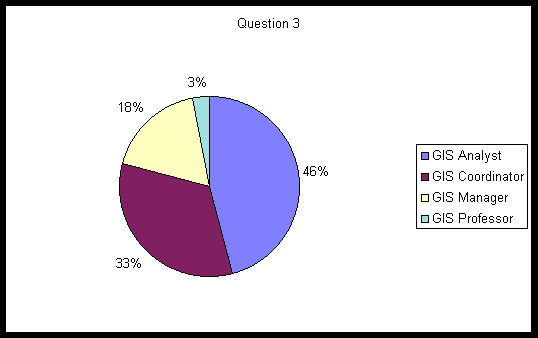
Figure 3. Graph displaying current job titles of respondents.
Question four begins the first of four questions used to evaluate the hypotheses presented in this thesis. These hypotheses relate to the perceptions which GIS professionals have toward GIS certification and GIS as a profession. The fourth question asked the respondent if he/she thought that GIS should be classified as a profession. A likert scale of one through five with one representing strongly agree and five representing strongly disagree was used to test the sample.
A one-sample t test was performed to test each of the four hypotheses within this thesis. A significance level of .05 was used on the four hypotheses to determine the statistical significance of each hypothesis result. The lower tailed test was used to detect a mean < 3, where 1 is equal to strongly agree and 2 is equal to agree. The value 3 (on the scale of 1 to 5) was chosen as the null mean because it is the middle of the likert scale (neutral). This would indicate that any result with a mean < 3 supports the hypotheses. The null hypothesis states that any results with a mean > 3 would not support the hypotheses, which in that case would favor further testing of the hypotheses. In testing the results for question four [t (-10.3) = 0.00, p < .05], meaning that the sample mean 1.92 is significantly lower than the null hypothesis mean 3. Therefore, the questionnaire responses support the hypothesis that GIS professionals perceive GIS to be a profession. See figure 4 for charted results.
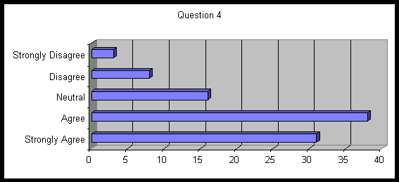
Figure 4. Shows respondents who think GIS should be considered a profession.
Question five asked the respondent if a GIS certification should be developed to insure highly qualified GIS professionals. Again a likert scale of one through five was used to categorize responses, with one representing strongly agree and five representing strongly disagree. In testing the results of question five [t (-11.3) = 0.00,p < .05], meaning that the sample mean 2.02 is significantly lower than the null hypothesis mean 3.
Therefore, the questionnaire responses support the hypothesis that Geographic Information Systems professionals perceive that a certification process should be established in order to insure a higher level of competency in the GIS profession. See figure 5 for charted results.
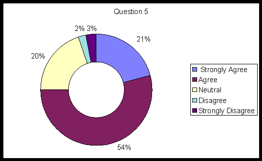
Figure 5. Shows the respondents answers to question 5.
Question six asks the respondent if a GIS certification process would insure more marketability for GIS professionals. A likert scale of one through five was used to measure responses, with one representing strongly agree and five representing strongly disagree. In testing the results of question six [t (-11.7) = 0.00,p < .05], meaning that the sample mean 2.13 is significantly lower than the null hypothesis mean 3. Therefore, the sample responses support the hypothesis that GIS professionals perceive that certification would improve their marketability. Figure 6 shows chart results.
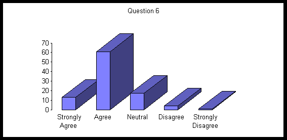
Figure 6. Exhibits the response that a GIS certification would insure more marketability for GIS professionals.
Question seven asked respondents if a GIS certification would insure that GIS professionals would produce a higher quality of work. Again a likert scale of one through five was used to categorize responses, with one representing strongly agree and five representing strongly disagree. In testing the results of question seven [t (-3.19) = 0.00094,p < .05], meaning that the sample mean 2.67 is significantly lower than the null hypothesis mean 3. Therefore, the sample responses support the hypothesis that GIS professionals perceive that certification would improve their quality of work. See figure 7 for charted results.
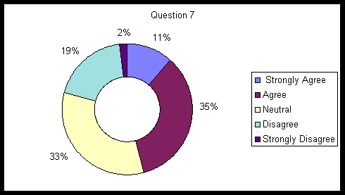
Figure 7. Exhibits survey results to certification improving GIS professionals' quality of work.
Question eight asked the respondent to choose characteristics which best help to define a GIS professional. Options given included: college education, specialized training, years in the field and certification program. Of the four possible responses, all four were included in the sample. The majority, 36%, of the responses classified years in the field as a characteristic which best defines a GIS professional, 34% specialized training, 16% certification program and 14% college education (see figure 8).
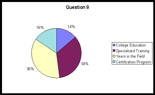
Figure 8. Shows the sample choices for the best characteristic which describes a GIS professional.
Question nine asked the respondent to choose the year in which they think a GIS certification should be implemented. Options given included: 2001, 2002, 2003, 2004 and never. Of the five possible responses, all five were included in the sample. The majority, 30%, of the responses chose 2004 for GIS certification to be implemented, 26% 2003, 18% 2002, 13% 2001 and 13% never (see figure 9).
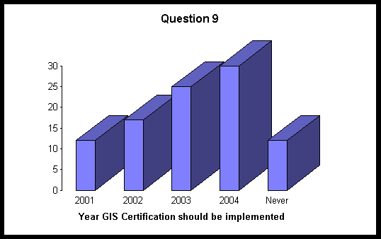
Figure 9. The year respondents think that a GIS certification should be implemented.
The sampling of the four hypotheses presented in this thesis clearly exhibited positive responses. A complete summary and further recommendations will be presented in Chapter V.
This research was an analysis of the necessity of a GIS certification. The hypotheses developed for testing were as follows:
Ho: GIS professionals perceive GIS to be a profession.
Ho: GIS professionals perceive that a certification process should be established in order to insure a higher level of competency among the GIS profession.
Ho: GIS professionals perceive that certification will improve their marketability.
Ho: GIS professionals perceive that certification will assure their quality of work.
In order to determine respondents' opinions regarding a GIS certification, the descriptive survey method was employed. Questions were designed to qualify the respondents and inquire into their beliefs regarding GIS certification as far as insuring a higher level of competency, improving marketability and assuring quality of work.
As the results in Chapter IV indicate, the respondents have an average of 6 years' experience in GIS. The GIS jobs held by respondents are that 45% are GIS analysts, 33% are GIS coordinators, 18% are GIS managers and 3% are GIS professors.
An impressive majority, 75%, believe that a GIS certification process should be established to insure higher levels of competency in the profession. 72% of the respondents went on record as agreeing that a GIS certification would insure more marketability for GIS professionals.
Survey respondents demonstrated a 46% majority in agreeing that GIS certification improves GIS professionals' quality of work. In choosing the best characteristics which describe a GIS professional, 36% registered years in the field, 34% responded specialized training, 16% indicated a certification program and 14% denoted a college education. An issue revealed in relation to this survey question was that some respondents inquired if they could circle more than one choice, rather than their best answer as directed. This indicates GIS professionals believe that GIS expertise derives from a combination of characteristics, such as specialized training and years of experience.
When asked to choose a year when he/she thinks a GIS certification should be implemented, 30% chose 2004, 26% indicated 2002, 13% answered 2001 and 13% registered never. As a result over 75% of GIS professionals surveyed think a GIS certification should be developed.
While it is true that GIS does not meet all six criteria of a profession as addressed in Chapter II, it would only entail the formulation of a set of high GIS standards and the creation of a code of ethics to complete the requirements. Considering that most GIS workers, 69% of the respondents surveyed, regard GIS as a profession, it seems only logical and sensible that the GIS community concentrate first upon resolving the GIS profession question.
Employers and the GIS workforce need to be aware that a GIS certification by itself is not sufficient for GIS expertise. Rather, a combination of factors as indicated above-education, specialized training and years of experience-must also be part of the GIS repertoire. A GIS certification would be an additional qualifier toward a GIS professional's performance excellence.
Based upon the research presented in Chapter II and the survey results presented in Chapter IV, the institution of some form of a GIS certification is indicate. GIS organizations such as URISA, NCGIA, UCGIS, NSGIC, OGC, AAG, ASPRS, ACSM, MAPPS, NIMA, AGI, ISO and AURISA are the logical ones to devise a certification program and see to its implementation. One individual representative from each of these GIS organizations could form a committee to design a GIS certification program. As there is no doubt that all GIS workers would like to see GIS regarded as a profession, it would seem a logical step that the same GIS committee also devise a set of high standards for GIS as well as a GIS code of ethics.
This thesis addressed some important issues of a GIS certification, but determining the necessity of a certification is still unclear. If as a GIS worker we want to be regarded as a higher level professional, it seems that the GIS certification process is inevitable. As this topic continues to be discussed intently through GIS circles worldwide, GIS professionals must set their own high standards and code of ethics until a professional one is set for them. One crucial point is evident: Whether or not an individual is an advocate of a GIS certification program, it behooves him/her to grant unwavering support to the GIS community and all of their collective efforts and decisions.
Trisha W. Brush September 12, 2000
(H)(816) 322-5113
(W)(913) 294-9531
Fax (913) 294-9545
limo@micoks.net
Dear GIS Professional,
I am requesting your expertise as a knowledgeable professional in the GIS Industry. I am currently in the Master of Business Administration (MBA) program at Baker University. As a requirement for my MBA I have chosen to research the needs for a GIS certification, a topic that will not only benefit myself but all GIS professionals. My goal is to gain a greater insight on the views of real GIS professionals like you on this hot GIS topic.
Please know that all information obtained through this survey will remain anonymous and in the strictest of confidence. If you have any questions regarding this survey please do not hesitate to call or e-mail me.
I appreciate you taking time out of your busy schedule to reply to this survey. I am requesting that the surveys be turned in no later than June 1, 2001. Once the survey has been completed, please e-mail it back to me at the above address. Thank you for assisting me in my efforts and for making a difference in the GIS community.
Best regards,
Trisha Wildey Brush
GIS Certification Survey
Yes No
GIS Analyst GIS Coordinator GIS Manager GIS Professor
Strongly agree Agree Neutral Disagree Strongly disagree
Strongly agree Agree Neutral Disagree Strongly disagree
Strongly agree Agree Neutral Disagree Strongly disagree
Strongly agree Agree Neutral Disagree Strongly disagree
College education Specialized training Years in the field Certification program
2001 2002 2003 2004 Never
Albrecht, Jochen. "GIS Certification: what URISA could learn from related initiatives in the spatial industry." Proceedings of the '99 URISA Conference, 21-25
August 1999. Chicago, IL: URISA, 1999: 571-76.
Ayers, Lawrence F. and Clifford A. Kottman. "A Call for GIS Certification." GIS World December 1994: 48-52.
Bennion, F., B. Capper and D. Unwin. "DRAFT Professional Development for the Geographic Information Industry." Association for Geographic Information
(AGI), Information and Education Committee: 1997.
Burley, Jon Bryan. "GIS Certification: Precedents and Choices." URISA Journal Fall 1993: 17+.
Butler, Al. "Where Is the Line Between Surveying and Mapping?" Proceedings of the 2000 URISA Conference, 19-23 August 2000. Orlando, FL: URISA,
2000: 437-441.
Chamard, R.R. "Mapping Scientist Certification: ASPRS Program." Proceedings of the '96 GIS/LIS Annual Conference and Exposition, 19-21 November
1996. Bethesda, MD: ASPRS, 1996: 675-80.
Esri (Environmental Systems Research Institute). GIS.com. November 2000. <http://www.gis.com/whatisgis/index.html>
---. GIS for Everyone. California: Environmental Systems Research Institute, Inc., 1999: 28.
---. Understanding GIS. New York: John Wiley & Sons, Inc., 1995: i, Glossary 18. Goodchild, Michael F. and Karen K. Kemp. "GIS Accreditation: What
are the options?" ACMS (American Congress on Surveying and Mapping) Bulletin: 45-47.
Gore, Al. "The Digital Earth: Understanding Our Planet in the 21st Century." California Science Center's Grand Opening Gala. Los Angeles, California. 31 Jan.
1998. URISA News May/June 2000: 10.
Huxhold, William E. "Certifying GIS Professionals." URISA.org. April 2000. Slides 1-19. <http://www.URISA.org/GIS_CERT_PRES/sld001.htm;
Obermeyer, N.J. "Certification in GIS: More Trouble Than It's Worth?" Proceedings of the '91 GIS/LIS Conference and Exposition, 28-31 October 1991.
Bethesda, MD: ASPRS, 1991. 459-66.
---. "Certifying GIS Professionals: Challenges and Alternatives." URISA Journal Spring 1993: 67-75.
---. "Response from Nancy Obermeyer, Certification Committee Chair."
Pugh, Darrell L. "Professionalism in Public Administration: Problems, Perspectives, and the Role of the ASPA." Public Administration Review
January/February 1989: 1-8.
Schuckman, Karen, CP, PLS. "One Last Thing Shining a Light on Licensing." Geospatial Solutions April 2001: 58.
Somers, Rebecca. "Defining the GIS Profession and Debating Certification and Regulation." Geo Info Systems May 2000: 22+.
Wikle, Thomas A. "Continuing education and competency programmes in GIS." International Journal of Geographical Info Science July/August 1998: 491-
507.
Trisha Wildey Brush
GIS Coordinator
Miami County, Kansas
201 S. Pearl St.
Suite 201
Paola, Kansas 66071-1777
Ph: (913) 294-9531
Fax: (913) 294-9545
e-mail: limo@micoks.net