GIS and Sign Management on the Highways of Pennsylvania
Howard S. Hodder, Jr.
Abstract:
This paper presents the use of GIS in the Sign and Logo Management processes of PALOGO. It will describe the use of ArcView, CarteGraph’s SignView, Microsoft Access 97 and GPS to manage the installation and upkeep of public service highway signage throughout Pennsylvania. Base map layers were provided by the Pennsylvania Department of Transportation and sign data was collected from a variety of sources including field verification with digital photography and GPS.
Introduction:
With the creation of large, extensive highway systems came the need for informative signage for commuters and travelers without destroying the landscape with non-standardized signs. These larger non-stop highway systems replaced or bypassed the more congested stop-and-go roads through cities and towns. Thus, the every day commuter and foreign traveler is left with guess work in finding a quick and convenient place to refuel their vehicle, rest for the night, get a bite to eat or experience interesting places the cities and towns offer close to the highway.
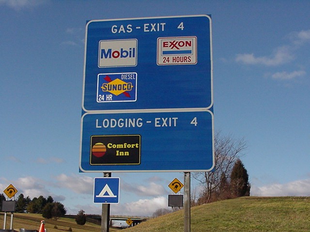
The Pennsylvania Logo Signing Program provides the needed informational signing service for motorists on Pennsylvania’s highways through an effective partnership between the private and public sectors. The program operates under Pennsylvania’s Department of Transportation (PennDOT) supervision determining how business logos and mounting signs are designed, installed and maintained. The installed signs and logos provide the traveler with exit and directional information aiding in locating desired services required by the motorist. The program uses these special exit signs to highlight attractions, campgrounds, food, gas, and lodging facilities located near highway exit off-ramps.
Through the use of GIS and two specialized databases, information about, and upkeep of service signs have become a less tedious process. It also allows for quick, accurate retrieval and reporting of information and aids in a more simple expansion of the program to more exits and interchanges in the state.
History:
In 1983, the Pennsylvania Department of Transportation (PennDOT) initiated a pilot project aiding the state’s interstate travelers. PennDOT proposed a logo signing project on I-84 from Scranton to New York State at approximately six interchanges. This project was funded with both State and Federal monies with the largest percent, about 90%, provided by the Federal Government. The program’s participants were charged an annual nominal fee according to the number of logos that were erected for that business. In 1984, a Logo Signing Trust Agreement was created turning the entire administering of the project over to the Pennsylvania Travel Council. It also established that State or Federal Highway funds not be appropriated to the program. Although PennDOT owns the mounting signs and the rights-of-way in which they are installed, the program is funded entirely by the participating businesses.
Logo Signing Trust:
Pennsylvania’s Logo Signing Program is administered by the Pennsylvania Logo Signing Trust, a non-profit organization established through the Logo Signing Trust Agreement between the Pennsylvania Travel Council and the Trustees. PennDOT is established as the beneficiary of the program and the Pennsylvania Travel Council as the nominal grantor. The Pennsylvania Logo Signing Trust is authorized ""to administer with PennDot the Program to provide signs along the interstate highways throughout the Commonwealth of Pennsylvania to show the brand, symbol, trademark, and/or name of the gas, food, lodging and camping establishments which are readily available at interchanges along such interstate highways for the benefit of the general public..."" Additionally, the Trust was authorized to establish and collect fees, pay expenses and provide for long-term financial viability of the Program and to "Execute contracts and administer the program in a manner comparable to that required of PennDOT, if PennDot were directly administering the Program itself." The Trust Agreement also requires that the program be administered in a fair, reasonable, non-discriminatory, and equitable manner. (Trust Agreement)
The Trust Agreement calls for eight appointed Trustees. At least three of these appointees are to be representatives of for-profit corporations employing less than 500 full- time employees including the company’s parent, subsidiaries and affiliates. No more than three Trustees can be members of the Pennsylvania Travel Council Board of Directors. One Trustee represents the traveling public, one the outdoor advertising community in Pennsylvania and one the Pennsylvania Department of Transportation. Four of the five classifications of service, food, lodging, gas, campgrounds and attractions, must be represented at all times. A Trustee may fill one or more of the composition requirements and serve for two years with no compensation, except for the reimbursement of out-of-pocket expenses associated with their duties as a Trustee.
Herbert, Rowland and Grubic, Inc. Involvement:
Herbert Rowland & Grubic Inc. (HRG, Inc.) is a Civil Engineering and Consulting firm with six offices spread across the Commonwealth of Pennsylvania. The Logo Signing Program is primarily the responsibility of a full-time team of engineers and CAD drafts-people in the Harrisburg Branch Office with Database and GIS advisement provided from the Lancaster Branch Office. Each office in the network of HRG, Inc. has helped at one time or another in the Logo Program whether it was engineering, data collection, input, inspection or general advisement.
The Logo Signing Trust approached HRG, Inc. to be the advising engineering firm on the project. Many years of quality service to the Trust allowed marketing of other possible services, such as GIS, to be openly considered and eventually adopted as useful tools in sustaining the services of the program.
HRG, Inc. was hired to create a Windows based database to replace a .dos based program which was used at the initial implementation of the program to organize the participating client information. Microsoft Access 97 was adopted as a solution to the request. The program gave the Trust an affordable, flexible and customizable platform to create user-friendly data input and extraction techniques corresponding with the growth and demand of the Trust. This database holds the entire client listings, contract information, billing amounts, and contact and shipping information for participating and past patrons along with information on pending clients. From Access 97, many reports, counts, and queries can be easily created, saved and accessed as needed in answering many of the clients’ and Trustees’ questions. It also provides needed contact and mailing information frequently merged into Microsoft Word documents for individual client and mass client mailings.
It was determined that with the extensive growth of the project, it would be beneficial to keep a database of information on the physical mounting signs to which the clients’ logos are attached. SignView created by CarteGraph, Inc. was chosen for the project. SignView is a program designed for collection, inventory, maintenance and management of sign assets most often associated with municipal signs. Though mapping of signs like those of the Signing Trust Program was not its initial intent, it was flexible enough to conform to the needs of the Trust to manage the physical attributes of the mounting signs in the program.
The sign inventory phase incorporated the use of current shop drawings of intersection layouts, and field data collection and digital photography of each sign installed since the beginning of the program. This process uncovered errors in some drawings and also gave a prime opportunity to inspect each of the signs in the program. Along with digital photos, measurements and other physical characteristics like back-panel sheeting types, mounting bracket and post information was obtained. This data was then incorporated into SignView creating a more accurate account of the mounting signs in the program. The digital photos now offered a quick reference to what the sign actually looked like and what logos were present on the sign.
SignView also offered a way to help keep track of work orders on signs that needed to be changed, installed, fixed or just routinely inspected. Work done on the signs can now be tracked easily for future reference. Also, it gives an easy way to sort and access only certain signs that may be of interest at a given time, reducing the time needed to dig through old paper shop drawings. A history log is created each time a record is changed in any way. This allows future users to view changes to the record of a sign in the database, from anything like a routine inspection to an entire new sign installation.
CarteGraph also provides the MapDirector extension. When used with ArcView, it develops a point layer and also allows the user to graphically select a group of points representing signs, and automatically sort the SignView database to just those records. This linking function allows for the selection of only the wanted data fields selected from the SignView database to be visible as a table corresponding to the point asset layer created with MapDirector. Thus, digital images can be accessed through ArcView by linking the hotlinks tool to the field containing the pathname to the images in SignView. An easy point and click then allows the user to view images quickly for each point of interest directly through ArcView.
Data for the GIS base-mapping was obtained from PennDOT, being they are the beneficiaries of the program. Layers such as road centerlines, PennDOT engineering districts, Counties, Townships, and Boroughs are incorporated into the mapping project and allow for easy theme-on-theme attribute selection of desired signs.
The final phase of this large project is the creation of a point layer for the linking of the databases and GIS. SignView provides a location tab in the database to enter GPS, x,y,z, attribute information. Once the points are collected, they can be easily downloaded into SignView and be generated as a point asset them in ArcView through the MapDirector extension giving an accurate sign location description. Without GPS, points can be placed using MapDirector, but then sign locations would be more of a guess with very little accuracy. The GPS phase also allows for another chance for the general sign inspection and collection of any previously overlooked data.
Since the statewide data provided by PennDOT is not extremely precise, the GPS units being used for the data collection do not have to be survey accurate. The Trimble GeoExplorer 3 is the handheld GPS unit chosen for the collection. It will provide about 1 to 5 meters precision after differential correction. This precision is more than suffice for the project’s needs and the base mapping layers involved.
The GPS data collection has started and is to be worked on in different phases across the state in the next few years. After it is completed, it will be standard practice to take a GPS reading and a digital photo each time a new installation takes place. This coordinate data, combined with the physical attributes of the sign and business logos mounted upon it, will give a true and accurate representation of the signs and logos involved in the program allowing for easier administration and coordination of the Signing Program.
Conclusion:
The Pennsylvania Logo Signing Trust Program continues to receive a positive response from the business community and traveling motorists. The duel nature of providing an affordable advertising opportunity for businesses combined with the ease of use for travelers produces a program that is pleasing to all involved.
By taking advantage of the technology available, like GIS and user-friendly databases, the Logo Program will be able to grow even larger each year with little effort. The once one interstate route, with few exits and informational signing, has now grown exponentially and continues to grow into a network reaching thousands of motorists yearly. Beacasue of GIS and integrated database systems, this growth becomes less of a tedious task and mroe of a profitable one for the Pennsylvania Logo Signing Program, and the growing number of motorists taking to the highways and interstates each day.
References or Acknowledgments:
Pennsylvania Logo Signing Trust and the Pennsylvania Travel Council, 902 N. Second Street, Harrisburg, PA 17102.

Pennsylvania Department of Transportation. GIS Department.
www.dot.state.pa.us 
Herbert, Rowland and Grubic, Inc., 369 East Park Drive, Harrisburg, PA 17111.
www.hrg-inc.com