Building on the South Texas Geographic Data Committee Regional Base Map Program, the Greater Harris County Emergency 9-1-1 Network, Houston Police Department, Houston Fire Department, Harris County Judicial Information System, and other public safety agencies have joined forces to create a single, accurate, and up-to-date spatial database. This spatial database was created to meet the needs of public safety in the greater Houston area. This GIS database is used for E-911 mapping and computer aided dispatch (CAD) by the Houston Police and Fire Departments, and the Harris County Sheriffs Department. Other law, fire, and public safety agencies are also using, and are involved in the updating, refinement and accuracy of the spatial database. This paper describes the integration of multiple agency databases, multiple agency coordination of efforts, and the lessons learned in the development of an accurate spatial database useful for a wide variety of public safety agencies.
While many organizations use Geographical Information Systems (GIS) to improve decision-making, the Houston Public Safety GIS Project is using it for very different reasons. Probably nowhere else is the need for complete, current, accurate, and precise spatial information more important than for emergency response for public safety. Beginning with the initial 911call, until the proper responding agency arrives at the incident, the spatial data must be correct at all times, peoples lives are quite possibly at stake.
Initially the Houston Public Safety GIS Project was a means for the Greater Harris County E911 Network, the City of Houston Police Department, and the Houston Fire Department to create and maintain spatially correct road and addressing information. The project has now become known as simply the Public Safety GIS Project. The project has expanded to over 35 public safety related agencies in the greater Houston area. Building on the South Texas Geographic Data Committee Regional Base Map Program and data model (STAR*Map), the Greater Harris County Emergency 9-1-1 Network and other public safety agencies have joined forces to create a single, accurate, complete, and up-to-date spatial database for public safety. The spatial databases are being used for E911 call taking, police and fire dispatch, emergency planning and response, and many other public safety related applications. The law, fire, and public safety agencies, in the project, are actively involved in the updating, refinement and accuracy of the spatial database. All base layer information collected by the Public Safety GIS Project is maintained and updated into the STAR*Map.
The STAR*Map (a contraction of Southeast Texas Addressing and Referencing Map) project covers a 13 county area, and is a multi-jurisdictional, multi-organizational, cost and data sharing partnership of over 40 regional governmental, public, and private agencies. Partnerships such as the STAR*Map project should always be considered as they can greatly reduce the cost, while increasing the accuracy of spatial data. As more agencies join such a partnership, the greater the cost savings and the potential for developing win-win agreements is greatly magnified.
Building on the STAR*Map base and data model, regional law enforcement, fire suppression, and similar agencies are developing information specific to public safety. The public is usually connected to agencies concerned with public safety by a call to 911.
911 is the number to dial for the fastest possible response when you need emergency law, fire, or medical assistance, in a life or death situation. When one dials 911 a complex series of advanced telecommunication processes begin to take place. In the case of a wireline telephone, such as the phone in your home that is connected by wires to a phone jack, your call is routed to a Public Safety Answering Point (PSAP), where the proper response agency can be dispatched. A historical review may be in order before we dive into the details of 911.
The origin of 911 can be traced back to England, 1937. England was the first country to use a national three digit emergency number. In England, dialing 999 would put you in contact with emergency service personnel. In 1958, the International Association of Fire Chiefs advocated for a national emergency number in the United States. However, it was not until 1968 that 911 was brought to reality through the coordination of AT&T and emergency service providers, resulting in AT&T making the digits 911 available for national use. This event marked the beginning of the growth of emergency number associations and professional organizations. As you read this paper, will probably swear it started an avalanche of acronyms as well.
While this was a major step towards decreasing emergency service response time, 911 technology did not yet have the ability to tell the 911 operator who the caller was or from where the call was originating. The sending of the phone number, owners name, and address of the emergency call did not begin until 1986. This was the beginning of Enhanced 911, or E911 for short. Basic 911 services will connect one with the 911-call center. E911 will provide the 911-call center with information on the address and owners name associated with the 911 calls.
For a cellular 911 call, also called a wireless 911, the caller must provide the location information to the 911-call center; the ability to accurately locate a wireless call is not available at this time. While wireless phones can not yet be automatically located with any degree of accuracy, which is unfortunate since experience has shown that most wireless 911 callers do not know where they are, new Federal Communication laws will soon move toward resolving this issue.
When a wireline 911 call is made, it travels over the public telephone service equipment to a local central office (CO). The CO is a digital switching network - which recognizes a 911 call - and routes the call through a high-speed dedicated 9-1-1 network to a specially equipped phone switching office, called a tandem. The voice information and the phone number of the caller are both sent to the tandem.
The tandem receives the voice and the telephone number of the 911 calls. The telephone number was automatically sent, similar to a caller id service, by the CO. This Automatic Number Information is called an ANI. The ANI is used by the tandem to query a database to determine the correct routing for the 911 calls. The database query on the ANI instructs the digital switch in the tandem to route the call to the Public Safety Answering Point (PSAP) responsible for the geographic area that the 911 call. The diagram below may help with following the call flow.
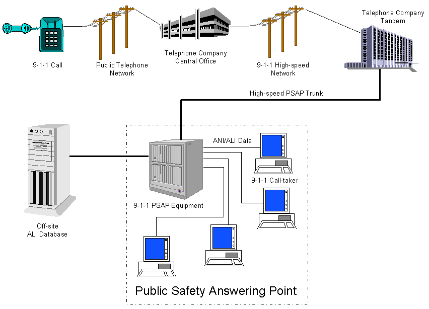
The routing of the 911 calls, by the tandem to the proper PSAP, is performed by a selective routing database. The tandem may also be called the selective router.
The 911-voice call and ANI information then arrives at the PSAP. As the 911-call taker answers the call, computer equipment in the PSAP sends a query to another database to obtain the location information of the call. Since privacy is a major concern, the phone number information and the telephone owners name and address are stored at different locations.
The ANI is sent through high-speed trunk lines to an offsite database, which queries the name and address of that phone number. The ANI query returns the address of the telephone and the telephone owner�s name. This information is called Automatic Location Information or ALI, and it is sent back to the PSAP, along with the ANI. The ALI addresses is parsed out of the data stream, geocoded against the GIS database, and all the information is presented to the 911 call taker. All this is done without human intervention and is available to the E911 call taker as soon as they answer the 911 call. Routing a wireline call to the proper PSAP and having a call taker answer usually takes less than three seconds.
The information used to perform the matching of the telephone number and the physical address of the telephone making the call is a critical component of moving spatial technology into public safety. Each wireline telephone has a physical service address, usually the address the phone bill comes to. The physical address of the phone is part of the ALI data sent back to the PSAP. This ALI information is parsed out and geocoded against the map display. The database that contains all the street names and addresses of all the telephone subscribers is called the Master Street Address Guide, or MSAG for short. The MSAG contains tabular data of all the street names and address ranges that may come across the tandem. If the MSAG, used to send the ALI address, matches the spatial road and address information in the GIS, then geocoding will be successful. If they do not match, then the map will not properly display the location information.
Each address in the MSAG is given an Emergency Service Zone or Emergency Service Number which corresponds to the proper responding agency. Each PSAP has one or more Emergency Service Zone (ESZ) which they take calls for. PSAP and ESZ boundaries are both polygons in the GIS. The ANI is used to query the offsite database, which knows the location of all the wireline phones, based on service addresses. All the street names and address ranges are stored in a tabular MSAG database. The MSAG also contains the correct ESZ of the address. The ANI is used to assign the ALI, it uses the MSAG for addressing. The ALI, and other information, is sent back to the PSAP. The PSAP parses out the location information from the ALI and uses it to geocoded against a spatial database for map display. From the time one places a E911 call until this entire operation is completed and a human voice answers you call, takes only a second or two. The geographic location of the PSAP boundaries, the ESZ boundaries within the PSAP, and the actual location of an address is very spatial in nature, but is presently performed with tabular files.
The E911 call flow described above works very well, usually 99.99 percent of the E911 call are correctly routed and answered. While 99.999 percent is fantastic, it is usually the one call in 10,000 that ends up on the front page of the newspapers or on the local news. Wireless technology is causing this near 100% call routing and answering to drop. We do not know where a wireless call is coming from with any degree of certainty.
There are two types of E911 wireless calls, Phase I calls and Phase II calls, named after the Federal Communication Commission (FCC) mandates describing how wireless 911 will provide location information to the PSAP.
Phase I wireless E911 calls must provide the following to a PSAP:
Phase II wireless E911 calls must must provide the following to a PSAP:
Phase I calls are being received by those PSAP ´s that request them. Phase II calls are mandated to begin on October 1st of this year.
Wireless phones and other wireless location devices are the driving force of GIS use and awareness in public safety. Most PSAP�s rely on tabular databases of addresses and block ranges to direct the responding agency to a call for help. These tabular databases usually do not provide adequate information to assist in locating wireless calls, especially if the caller or the call taker is unfamiliar with the area.
The call flow of wireless calls to 911 is a bit more difficult. For the sake of brevity a typical E911 wireless call travels from your handset to a cell tower. From the cell tower the voice, and cell tower and sector information, is sent by high-speed trunk lines to a Mobil Switch Center (MSC). The MSC is a highly specialized digital switch that acts as a hub and a concentrator, which relays your call to a Selective Router. Your cell phone has a unique electronic serial identification number. The MSC can translate this Electronic Serial Id Number into your mobile phone number. The MSC relays the mobile phone number, an emergency routing number, and the voice to the Selective Router. The database loaded into the Selective Router has an entry for this cell tower and can tell the Selective Router which PSAP to route the wireless call to based on the cell tower and cell sector the call came in from. There is more to it than that, but the PSAP now gets a wireless voice 911 call, if the PSAP is Phase I compliant, they also know the cell tower and sector the call was placed in. This effectively reduces the area the wireless call is being made in down to somewhere between 3 to 50 square miles. There are many variables involved with how far a cell tower can relay a wireless phone call.
A Phase II wireless call works similar to a Phase I call except that the MSC also sends a request to another highly specialized device to determine the location of the wireless call. This device is known as positional determination equipment. The position determination equipment performs the necessary calculations and sends back the geographic coordinates to the MSC. The MSC relays all the information on the wireless 911 call to the Selective Router. However, the Selective Router is using a tabular database to properly route the wireless calls. This is where GIS technology again comes into play; we need to route this wireless 911 call to the proper PSAP based on a location coordinate.
A simple point-in-polygon operation will work, if all the information is available. The point-in-polygon,of the wireless 911 caller position inside a PSAP boundary polygon layer, is handled by a third party mechanism. The Selective Router is not spatially enabled, so the wireless call location is "run through" a coordinate routing database, then information on routing the call to the proper PSAP is relayed back to the Selective Router. Typically, wireless Phase I Calls route to the proper PSAP in five to eight seconds. Phase II calls placed during testing were routed to the PSAP in eight to 20 seconds.
So GIS and related technologies are being used to route wireless calls to the proper PSAP. Phase I and wireline calls are being displayed in call and dispatch centers using the ALI information obtained from the MSAG as an address to geocode against. Geocoding the address allows the call takers to better understand the closest available responding unit, and other location based information. This is powerful technology and is helping reduce response time for emergency services, but there are a few things that need to be addressed.
Public safety is becoming more spatial, GIS technology is allowing us to reduce response time, but all this depends on having and accurate, complete, and current street and addressing information on a local scale. We need a spatially enabled Master Street Address Guide (MSAG) and accurate basemap information. GIS technology has come into public safety, and once people understand the benefits, it will not be going away.
Once the 911 call is routed to the PSAP, there is still the question of who the responding agency is. Each PSAP is broken down into Emergency Service Zone, within each zone there is a responding agency for law, fire, and Emergency Medical Services (EMS). Take a typical county for example. The entire county may be assigned a single PSAP. Within the county, there may be several small towns. Each town will probably have their own police, and fire / EMS agency. Outside, in incorporated county areas, there may be a sheriffs department for law enforcement, and several volunteer fire departments for fire suppression. There may be several ambulance services serving different areas of the county as well. Inside tone town, the local police and fire departments would respond to request for help. The Emergency Service Zone (ESZ) for that town will have the names and dispatch routing numbers of those agencies. The other town would have a different ESZ, since the responding agencies differ. The county could have several ESZ, depending on the Volunteer Fire departments and ambulance services areas of response.
For a Phase II wireless call, the PSAP will receive a longitude and latitude coordinate. This coordinate can easily be posted on a map display, but the map display must be spatially accurate for the correct agency to be dispatch to the proper physical location.
A properly designed, developed and maintained GIS database can be used to display the location of an emergency call by geocoding the ALI information. Geocoding is simply displaying a location on the map for a given address. The ALI record supplies the address, the GIS then performs geocoding to locate the ALI address on the map display. The GIS can also be used to route the call to the proper responding agency. Modern PSAP mapping software can also quickly determine the closest available responding agencies unit to the call, the quickest route for the unit to respond to the call, the quickest route to the hospital, and many other public safety related queries.
GIS is being used for many other applications within public safety. The E911 operations use it to identify areas receiving crank calls so educational programs can be targeted, identify and allocate resources, route wireless calls to the proper PSAP180;;s, and to correct and maintain the MSAG data. Law enforcement use GIS for detailed crime analysis, geo-profiling of criminal activity, determining areas which need an increase in law enforcement presence, locations for new stations or satellite offices, identifying trends or "hot spots" of gang or theft related activities, mobile applications, and more. The fire agencies are using GIS in their building code enforcement and inspection, fire district re-allocation, fire station sitting, resource analysis, incident analysis, false alarm analysis and tracking, pre-planning, tracking of SARA Title III and hazardous materials, mobile mapping, and others. The uses of a GIS in public safety are only limited by ones imagination. Using GIS for public safety has many applications, but they all depend on accurate, current, and correct spatial data. The road network and address layer is the "common ground" for public safety. Having a spatially accurate, complete, and correct layer to geocode against is no easy task, but it is a fantastic asset once it is developed and maintained.
In all but the largest urban areas, current geospatial data is lacking. Most databases are years out of date, spatially inaccurate, or do not have the attributed information required for emergency response and public safety.
An accurate and current spatial database can be used by all agencies in the public safety sector to increase their efficiency. Agencies, such as law enforcement and fire agencies, usually use Computer Aided Dispatch (CAD) and Records Management systems. These Computer Aided Dispatch (CAD) systems locate addresses by tabular files called geo-files. These geo-files should contain the street name and block address range of every road in their jurisdiction. These geo-files should match the MSAG, but rarely do. Part of the move to have a common street and address layer involves the synchronization of the CAD geo-files to the MSAG.
The single largest cost of implementing a GIS is the collection, creation, and often-overlooked verification and maintenance of digital spatial data. Data collection efforts have generally been conducted by individual agencies, without coordination with others, which may find the data useful. Efforts are duplicated, cost become prohibitive, and opportunities for win-win data sharing alliances are lost. With this in mind, it becomes important to always strive to seek out new data sharing and collection partnerships. Those involved must have realistic expectations about what can and cannot be done; the time involved; and the willingness to commit the human and financial resources necessary to develop the GIS.
Other agencies will be extremely interested in being able to obtain highly accurate address and spatial information. The interested agencies may include the local tax appraisal district; the water, and wastewater departments; the city and county engineer; city council; county commissioners; planning agencies; building code enforcement; regional and state governments; and private companies.
Private companies will benefit from having highly accurate street and address data. Seek relationships with companies such as the regional provider of electricity, gas, telephone, cable television, realtors, marketing groups, information providers, and others. Talk and meet with all these agencies, the idea of sharing resources, information, and cooperative purchasing must always be considered, investigated, and fostered between agencies and organizations.
Since this data would be beneficial to so many public and private agencies, one should always strive to form partnerships and data sharing alliances for collecting and updating the GIS information. Building an accurate addressed road network is a monumental task, and will require a substantial outlay of time, and expense. The best way to approach the task is through cooperation and coordination with all interested agencies and parties. It is not enough to have the most accurate and up-to-data spatial data; it must be maintained and refined in our ever-changing world. It all starts with an accurate base map.
Where does one start to develop this base map? Address information is the most common form of location information. Streets with correct address ranges form the very basis of a public safety GIS. The Public Safety Answering Point (PSAP) already maintains the most comprehensive database of streets and addresses in the Master Street Address Guide (MSAG). The local and regional law enforcement agencies, fire agencies, local planning, tax rolls, and many entities all have their own versions of the Master Street and Addressing Guide. However, MSAG�s are just tabular files, without the spatial information needed to display the streets on a map. You need a starting point, a spatial dataset to begin with, then time, determination, and cooperation to complete the task.
The first concept one should understand before developing or purchasing spatial data is that of scale. The positional accuracy that the mapped data is capable of achieving is expressed as the map scale. Scale refers to how the distance on the map relates back to the distance on the ground, a 1:100,000 scale map means that an inch on the map represents 100,000 inches on the surface of the earth, or about 8,333 feet. Freely available street data from the US Census Bureau has a scale of 1:100,000, but at this scale, a GPS coordinate may appear to be on an entirely different street. A Phase II wireless call can actually be several blocks away from where the map indicates.
There are many sources of GIS data including the US Census, the US Geological Survey, the US Environmental Protection Agency, many State and Regional agencies, perhaps even the local planning department or public utilities agency. Most GIS vendors provide some free data, and many companies supply data that may well meet your immediate needs. The Federal Geographic Data Committee (www.fgdc.gov) is a web site that should provide the names and contacts with agencies in your area that may be able to provide source data. The Federal Geographic Data Committee coordinates the development of the National Spatial Data Infrastructure (NSDI). The NSDI encompasses policies, standards, and procedures for organizations to cooperatively produce and share spatial data. The FGDC is comprised of 17 federal agencies, and many organizations from state, local and tribal governments, and the academic community.
There are several private companies, which will provide free spatial data, under partnership agreements, and assist in maintaining the data. One such company, Geographic Data Technology, Inc. (GDT - www.geographic.com), in partnership with Environmental Systems Research Institute, Inc. (Esri - www.Esri.com), has an innovative community update project (www.communityupdate.com). Esri also has grant programs to lessen the financial and technical burden and to foster partnerships. Programs such as this certainly merit consideration. One must always remember that incorrect or incomplete data may be very damaging, especially in the case of E911 operations.
Before developing any GIS data, one must consider many factors. There is a critical shortage of current spatial data available to all but the larger metropolitan areas. The selection of GIS data available for use in public safety can be a daunting task for anyone. It becomes even more confusing and stressful when the person does not understand industry buzzwords (and especially how salespeople often miss-use them) such as datum, projection, ellipsoid, scale, coordinate system, and so on. While many will have a good idea of what data is needed, the task of determining how to obtain or create the data is even more complex. Remember you are not purchasing a "map " but are purchasing a geographically referenced data set that can be displayed as a visual " map. " That data set should contain most of the information of a street network that is contained in your MSAG.
Factors to consider when developing spatial data is how the data will be collected and used by all involved agencies. The US Postal Service (USPS) has addresses for all mail delivery, but they often do not represent the physical address. How will the police, fire, city planning, private companies and all interested parties use the data? What are the common data elements, which need to be collected once, then used by all? Will it be compatible with existing software and hardware, will it easily link to the MSAG, Computer Aided Dispatch (CAD), and Records Management System (RMS)? These are just some of the many questions that should be considered.
The creation of an accurate "map" will require time and effort, the creation of an economical and accurate "map" will require coordination with other agencies that will use the "map" Often the local police, fire, EMS, sheriff, planning agency, assessors office, city and county engineer office, electrical company, gas company, realtors, and others are willing to share in the cost and manpower of developing and creating an accurate spatial database. This concept of data sharing and mutual benefit from cooperation cannot be overstated.
Creating an accurate and precise road centerline will be a time consuming task. Keeping the collected spatial data maintained and synchronized with existing data will be an arduous task. The best place to start is asking those who have already began developing GIS for public safety. Over the course of several years ´ many individuals who have helped develop GIS in public safety have defined the minimum information needed, known as the "Proposed GIS Data Model Format." These standards closely mirror other national standards for road naming, addressing, metadata, and other spatial standards. They also provide another layer of detail required for accurate location of emergency request. Proposed GIS Data Model Format
The National Emergency Number Association (NENA) GIS Study Group has defined the minimum layers and attributes needed for a PSAP. These minimum data sets and attribute information are described in the proposed GIS Data Model Format. These standards are presently open for public review and comment. The complete proposed standard can be found at the National Emergency Number Association website: www.nena.org
The minimum layers are:
Line DataDetailed information on the Proposed GIS Data Model Format is available through NENA. The following is an example of the data fields for the Centerline layer for streets and addresses:
Maintaining data integrity within the GIS and keeping the data synchronized with existing tabular files requires high levels of coordination. Transforming the traditional tabular location and address files into a GIS dataset will uncover many errors and discrepancies that must be resolved; procedures to implement these changes must be in place. In Harris County, within which is Houston, we found over fifteen different street name and address guides, none of which accurately represented the real world. Many had not been maintained, or had been maintained as funds became available. The city planning commission, county tax appraiser, voter registration, police, fire, sheriff, city and county engineer, and many other agencies all used a "Master Street Address Guide", but none were in synch with the others. This became part of our "Common Ground" to build partnerships, relationships, and collaborative efforts. It also was ground for some disagreements and miscommunications, but the results far outweigh the ruffled feathers.
An ongoing spirit of cooperation and coordination with other interested agencies must be maintained. These efforts will reduce redundancy of data gathering, lower cost, improve accuracy, increase precision, and maximize resources in maintaining and updating geographic information related to public safety operations. To minimize disagreements and ensure everyone is working toward the same goals, you need to set priorities.
Ensuring everyone will use the data collected and developed, you need to determine which standards to use, define the procedures, and set the priorities. One of the underlying principals of an effective GIS should be to collect the data once, then allow it to be used by all.
Standards set a framework for maintaining the spatial data, data integrity, interoperability, and consistency. The standards document the methods of collecting the data, entering the data, checking the data, verifying the data, and accessing the data. Standards also establish clear feature type definitions, formats, file formats, update procedures, naming conventions, and other items.
Standards allow for the standardization of spatial features, allows data to be integrated into other applications, keeps everyone on the "same page," and provides a common format that will reduce the learning curve. Since everyone is using the same common spatial data, the time required to develop common interfaces and training material is greatly reduced. Public Safety spatial data will require thorough quality assurance/quality control procedures.
Someone once said that the good thing about Standards is that everyone has one. In the case of public safety, the Standards used should be the National Emergency Number Association (NENA) Standards. These Standards can be found on the NENA web page (www.nena.org).
Procedures are the steps required for data acquisition and input into the GIS. Procedures outline the where the data is collected, how it is collected, the quality control, verification, and re-checking of the input results, and the standards which must be met prior to adding the data into the GIS. One can think of the procedures as a "cook book" approach of how to capture, check, and input all the GIS data.
Some of the aspects to consider when developing procedures include the following:
Priorities should be set so everyone knows where to concentrate their efforts. The development of a common street centerline and addressing attributes into a spatial database should be the first order of business. Everything else will depend on the creation of the street and address layers. Geocoding of other information cannot proceed until the street centerlines are created. Other priorities will vary depending on those involved in the spatial data creation, what data is available and countless other factors. Priorities should be agreed upon early in the development process. When assessing priority tempers may flare. Always remember that one must constantly maintain good will, good relationships, and open communications, while stressing cooperation.
| NAME | DESCRIPTION |
| Left Add Low | Lowest address on left side of street |
| Left Add High | Highest address on left side of street |
| Right Add Low | Lowest address on right side of street |
| Right Add High | Highest address on right side of street |
| Prefix Directional | Leading street direction prefix. |
| Valid Entries: N S E W NE NW SE SW | |
| Street Name | Valid service address of the Calling Telephone Number |
| Street Suffix | Valid Street abbreviation, as defined by the US Postal Service Publication 28. (e.g. Ave, Cir, SH) |
| Post Directional | Trailing street direction suffix. |
| Valid Entries: N S E W NE NW SE SW | |
| Road Class | Road Class as defined by the USGS National Mapping Product Standard for 1:24,000-scale and 1:25,000- scale Quadrangle Map Products. http://rockyweb.cr.usgs.gov/nmpstds/acrodocs/qmaps/5PSYM499.PDF |
| One-way | One way road classification |
| Blank = No | |
| X = Opposite Direction of arc | |
| Y = In direction of arc | |
| MSAG Community Name Left | Valid service community name as defined by the MSAG on the left side of the street |
| MSAG Community Name Right | Valid service community name as defined by the MSAG on the right side of the street |
| Segment ID | Unique Road Segment ID number |
| County ID Left | County Identification codes (usually the FIPS code) on the left side of the street in ascending order. |
| Note: County Identification field is used to identify the county of call origination. | |
| County ID Right | County Identification codes (usually the FIPS code) on the right side of the street in ascending order. |
| Note: County Identification field is used to identify the county of call origination. |
Wireless technology is bringing large increases in the demand for accurate and complete map displays in for public safety. How to assimilate the data is more complex than defining the data layers needed. It is extremely important to understand the level of accuracy required and how that accuracy relates to the available information. One should also realize that there is a point where the increase levels of positional accuracy are not worth the increased cost.
Digitizing from recent rectified aerial imagery produces accurate results, but imagery is expensive, especially without cooperative data sharing with other agencies. Probably the fastest and least expensive means to collect highly accurate positional data for the address layer is through GPS technology. GPS technology allows one to "drive the streets" collecting road centerline data. Many GPS systems also allow one to capture address information and information including building locations, fire hydrants, park and school boundaries. The collection of GPS data and related attributes has made great strides in recent years. It is becoming easier, quicker, and less costly to capture this type of spatial data.
Collecting road centerline data should also include capturing unique features. Being able to locate common landmarks - hospitals, public pools, buildings, landmarks, shopping centers, and the like - can dramatically reduce the time to dispatch the proper responding agency. This type of "Common Place" site information is often very helpful to a call taker receiving a wireless 911 call. Experience has shown that a large number of wireless callers just do not know where they are.
As the data is collected, modified, updated, and maintained it must also constantly be verified and re-checked. If time or money is not available to check, verify, and "scrub" the data, the PSAP is forced to work with inferior information, which can have unpleasant results.
Developing an accurate, current, and complete street and address layer, as a part of a national data infrastructure, allow accurate geocoding. Many applications of public safety rely on a this level of spatial detail to meet the needs of public safety. Other organizations will greatly benefit from a complete addressing layer. The needs are there, the rewards are great, and the cooperation and dedication to making it happen depends on the perceived need. Public pressure can be a great driving force, but data sharing and cooperation is clearly needed to develop and maintain such a base layer of spatial data.
This write-up was made possible with contributions from: