From 1973 to 1994 the metropolitan Charleston urbanized area grew by 256 percent. An additional 247 percent increase is expected by the year 2030. This growth is threatening the things that make the Lowcountry special. The South Carolina Coastal Conservation League launched the Greenbelt Education Project to highlight the threat to the region's resources through a series of maps and GIS-based analyses. This paper presents a 2030 urban growth projection, followed by analyses of agricultural and aquatic resources at risk.
The coastal region surrounding Charleston, South Carolina, known as the Lowcountry, is characterized by its clean and productive wetlands and waterways, farmland, and forests. The Lowcountry is also rich in history and culture. It is this combination of beautiful wildlife habitats and open spaces, historic areas, and abundant recreational opportunities that endears people to the Charleston area.
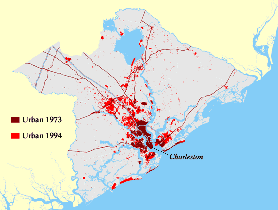
However, suburban development, in the form of sprawl, is consuming rural land at an alarming rate, threatening the things that make the Lowcountry special. In 1997 the Berkeley-Charleston-Dorchester Council of Governments (BCD COG) released a study, conducted in collaboration with other partners, in which urban growth in the three counties that make up the Charleston metropolitan area was analyzed, based on remote sensing imagery. The study showed that from 1973 to 1994, while the population of the region had grown 41 percent, the urbanized area had grown by 256 percent. This represents a 6:1 ratio of urban area growth to population growth. The extent of the urbanized area in 1973 and 1994 is shown in Figure 1. There is every indication that this trend will continue into the foreseeable future.
|
|
The Greenbelt Education Project: Keeping the Country in the Lowcountry was initiated to deepen the community's appreciation of, and attachment to, the rural landscape of Berkeley, Charleston, and Dorchester Counties through the creation of a series of maps and the analysis of associated geographic data. The Greenbelt Education Project is intended for a broad audience, including a variety of constituent groups, the media, and the general public. As such, the visual impact of maps can not be overstated.
The Greenbelt Education Project is a collaborative effort of a network of supporting organizations, each choosing its own level of involvement. The function of the Project is solely to share and distribute information.
The Greenbelt Education Project has been conducted in two discreet phases. The first phase was the creation of a predictive model for urban growth for the three-county Charleston region through the year 2030. The second phase involves inventorying various classes of Lowcountry resources and analyzing how those resources might be affected by the growth in urban area predicted by the model. The combination of the predicted urbanized area, or urban footprint, with the existing resources leads to the identification of resources at risk.
As much as possible, resource inventories have been assembled from existing data already available in digital format.
This paper reviews the creation of the 2030 urban growth prediction and then presents the at-risk analyses for agricultural and aquatic resources.
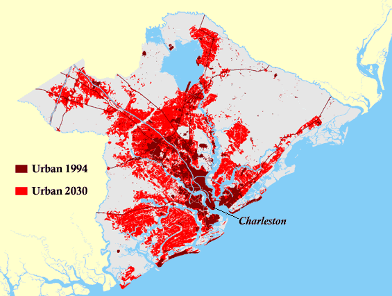
In order to identify resources at risk from poorly planned development over the next 30 years, it was first necessary to create a prediction of where such development is most likely to occur. Thus the 2030 urban footprint model for the Charleston metropolitan area was developed. The study to predict urban growth through the year 2030 for Berkeley, Charleston, and Dorchester Counties was funded by NOAA through the South Carolina Sea Grant Consortium and conducted by Clemson University's Strom Thurmond Institute for Public Policy (STI). The Clemson research team sought to model and predict the spatial extent of future urban growth through 2030 based on the historical trends of the 1973-1994 study, the physical environment, and the current policy constraints.
STI developed an integrated GIS model which incorporated statistical and rule-based modeling techniques and a focus group map. The focus group map was a relatively simplistic approximation of where growth might occur during the next 30 years based on the opinions of a group of experts, local officials, planners, developers, conservationists, and others having profound knowledge of the Charleston area and urban growth patterns. A thorough inventory of protected lands was assembled (including data from the US Fish & Wildlife Service and the Lowcountry Open Land Trust), to exclude areas where development will not occur, and a wetlands data set was also employed (from NOAA data), although this was not strictly excluded from future development. The integrated GIS model was performed using Arc/Grid on a UNIX operating system.
As an input to the model, it was assumed that the population of the three-county area will grow to 795,879 by the year 2030, as projected by the BCD COG, compiled from information from the US Census Bureau, the South Carolina Department of Commerce, and the COG. This represents a 49.4 percent increase over the 1994 population of 532,688. For modeling purposes, an urban growth-to-population growth ratio of 5:1 was used, slightly more conservative than the 6:1 ratio seen for the previous 21-year period. Thus, the percentage increase in urban area from 1994 through 2030 was predetermined to be 247, and the urban footprint generated by the model was therefore predetermined to cover a total of 553,160 acres. It was then up to the GIS model to determine where that growth would occur. This was an iterative process, and after each iteration of the model the resulting map was shown to knowledgeable experts throughout the region for further refinement.
The resulting urban footprint for 2030 is shown in Figure 2, where the 1994 urban area is shown in burgundy and the predicted growth is shown in red. The predicted 2030 urban footprint covers an area of 551,592 acres (as calculated by the ArcView Spatial Analyst extension). The 0.3 percent deviation from the 553,160 target figure can be attributed to fine adjustments to the grid data set and dependency on the method of area calculation. Table I lists the urbanized areas for the Charleston three-county region for 1973, 1994, and 2030, and the total area of the three counties.
 |
|
Area |
|
|
Total Area |
4.02 million acres |
|
Urban in 1973 |
44,789 acres |
|
Urban in 1994 |
159,412 acres |
|
Urban in 2030 |
551,592 acres |
It is emphasized that the Greenbelt Education Project 2030 Urban Growth Prediction is not an inevitable, unalterable scenario, but a depiction of what is likely to happen if current development trends are allowed to continue unaltered. It is an educational call to arms and, in combination with the identification of resources at risk in subsequent phases of the project, will serve as a tool to encourage more desirable development patterns and protection of the resources that define and sustain the Lowcountry.
All resources-at-risk data preparation and analyses were performed using ArcView 3.2 on a Windows 98 platform.
The collection of agricultural resources information contained four data sets: cultivated land, locations of the metropolitan Charleston area farmers' markets, locations of the farms that supply those farmers' markets, and locations of the other farms in the three-county region.
The cultivated land data is from NOAA's "South Carolina's Coast: A Remote Sensing Perspective" data set (formerly called the South Carolina Coastal Change Analysis Program, or C-CAP). The NOAA project studied changes in land cover for the South Carolina coastal region between 1990 and 1995 using Thematic Mapper (TM) satellite imagery. The satellite imagery was classified into 15 land cover classes. For the Greenbelt Project, only the 1995 classified data was used, as interest was in the most current data, rather than historic or change data.
The 1995 land cover classification data for Berkeley, Charleston, and Dorchester counties was selected from the larger data set in the form of Imagine-format (.img) raster image files. Using the ArcView Image Analysis extension, cultivated land(1) was extracted from the 15 land cover classes.
Grassland was also considered for the agricultural resources inventory but was found to include too much in addition to pasture land and was therefore not included.
The image files were then converted to grid files (using the Imagine Image Support extension) and all subsequent analysis was performed using the ArcView Spatial Analyst extension and related extensions or scripts, including merging the three county data sets into a single grid and projecting the grid from State Plane to UTM. Cell size was 30 meters for all grid data sets, and care was taken to insure that analysis extent always matched that of the 2030 urban footprint grid.
The locations of six Charleston-area farmers' markets were from the SC Coastal Conservation League's "Farmers of the Farmers' Markets" project. While these markets are in developed areas and are themselves not directly threatened by future development, they are an important component of the Lowcountry community and could be affected by the loss of the farms that supply them.
The locations of 32 local farms that supply the farmers' markets, also from the "Farmers of the Farmers' Markets" project, were included as one data set. This data consisted of a single point for each farmer.
A GIS data set containing the locations of 95 additional farms in the three counties was created from data collected by the Conservation League. Like the market farms data, this data consisted of a single point for each farmer. Each point included the owner's name, the type of crop, and the county.
Neither of the farms data sets indicated anything about how much land the farms covered, and were thus complemented by the cultivated land data set.
The total area of cultivated land in Berkeley, Charleston, and Dorchester counties was calculated from the NOAA-derived data using the Spatial Analyst's Zonal Analysis function on the grid data set.
The 2030 urban data was used to compute how much cultivated land lies inside what is considered to be urbanized area for the year 2030 and is therefore at risk. The Spatial Analyst's Map Calculator was used to multiply the cultivated land data set by a simplified form of the 2030 urban footprint(2), resulting in a grid containing the at-risk cultivated land. The Spatial Analyst's Summarize Zones function was then used to calculate the area.
The simplified form of the 2030 urban footprint, this time in shapefile format, was used to clip the farms data sets, and thus identify how many of the farms lie inside what is considered to be urbanized area for the year 2030, and are therefore at risk.
The results of the analysis of the agricultural resources data are presented in Table II and illustrated on the map in Figure 3. More than 57 percent of the cultivated land was found to be at risk of being lost to urbanization.
|
Present |
At-Risk 2030 |
||
|
Cultivated Land |
65,182 acres |
37,357 acres |
57.3% |
|
Market Farms |
32 farms |
30 farms |
93.8% |
|
Other Farms |
95 farms |
58 farms |
61.0% |
|
[Pass
your pointer over the map to see the 2030 scenario.]
Figure 3. Agricultural Resources at Risk: 69 percent of the
farms and 57 percent of the cultivated land in the Charleston region could
be lost to sprawl over the next 30 years.
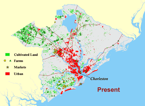 |
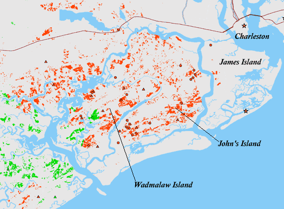
The region's farms are highly concentrated in two regions: northwestern Dorchester County and the Sea Islands region of Charleston County. Both of these areas are heavily impacted by the urban growth prediction, and, based on the analysis of the farm points, 30 of the 32 farmers' market farms, or 94 percent, and 58 of the 95 other farms, or 61 percent, lie within the 2030 urbanized area. Combined, 69 percent of all farms are at risk. Figure 4 illustrates the cultivated land and farms at risk in the Sea Islands region.
 |
Three data sets were selected as being representative of aquatic resources of the study area: fresh-water wetlands, tidal creeks, and shellfish beds. As urbanization reaches outward, the condition of these resources will almost certainly decline.
Data preparation, analysis, and results for each are presented separately.
Americans now realize that fresh-water wetlands provide many important benefits: flood control, pollution clean-up, aesthetic values, and more. Consequently, the Clean Water Act protects wetlands from the wholesale destruction of earlier generations. Nonetheless, urbanization impairs the function and quality of major freshwater wetland systems, and smaller wetlands are still filled during development.
The fresh-water wetlands data is from NOAA's "South Carolina's Coast: A Remote Sensing Perspective" data set. The 1995 land cover classification data for Berkeley, Charleston, and Dorchester counties was selected from the larger data set in the form of Imagine-format (.img) raster image files. Three land cover classes, "Palustrine Forest," "Palustrine Scrub/Shrub," and "Palustrine Emergent Wetland,(3)" were extracted using the Image Analysis extension and combined to represent the fresh-water wetlands.
The three county image files were converted to grid files and all subsequent analysis was performed using the ArcView Spatial Analyst extension, including merging the three county data sets into a single grid, reclassifying the three wetland classes into a single class, and projecting the grid. Cell size was again 30 meters for all grid data sets.
The total area of palustrine wetlands in the three counties was calculated from the NOAA-derived data set using the Spatial Analyst's Tabulate Areas function on the grid. (Zonal Analysis and Cell Count yield identical results.)
The 2030 urban data was used to compute how much palustrine wetland lies inside what is considered to be urbanized area for the year 2030 and is therefore at risk. The Spatial Analyst's Map Calculator was used to multiply the wetlands data set by the simplified 2030 urban footprint, resulting in a grid containing the at-risk wetlands. The Spatial Analyst's Tabulate Areas function was then used to calculate the area.
The amount of wetlands already affected by the 1994 urbanized area was also calculated in the same manner.
Prior to a recent Supreme Court decision wetlands were treated differently depending on whether they were less than or greater than one acre. Based on this cutoff, the above analysis procedure was repeated after separating the wetlands data into wetlands smaller than 1.0 acre and wetlands of 1.0 acre or larger. To do this, a region-group was first performed on the palustrine wetlands grid, and then the Map Calculator was used to generate the two new grid files, based on the fact that groups of five or more of the 30-meter cells have an area greater than one acre and groups of four or fewer cells were less than one acre.
The aquatic resources map in Figure 5 shows the freshwater wetlands for the three-county area. The results of the wetlands analysis, including the one-acre breakdown, are presented in Table III. Total Palustrine Wetland area for all three counties was 425,919 acres. Thirty-five percent of that, or 148,618 acres, lies within the 2030 urbanized area. It was found, however, that 30,083 acres of wetlands, or 7.1 percent of the total, are already within the 1994 urbanized area, illustrating the case where features can lie within developed areas. Thus 118,535 additional acres of wetlands (the difference between the 1994 and 2030 figures), or 29.9 percent of currently unaffected wetlands, are at risk of being affected by future development.
|
[Pass your
pointer over the map to see the 2030 scenario.]
Figure 5. The aquatic resources map shows the fresh water wetlands
and the tidal creeks for the three-county area. For visual purposes, only
wetland parcels of five acres and larger are shown on the map, and the width
of the tidal creeks has been exaggerated. It is emphasized that the actual
data was used for all analyses. Due to the small scale of this map the shellfish
beds are not shown. 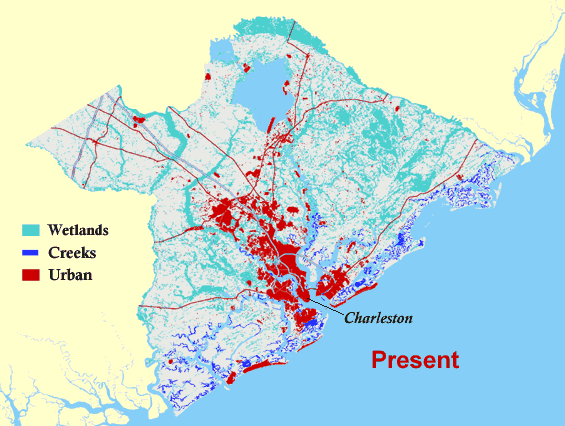
|
|
Present |
At-Risk 2030 |
||
|
Total Fresh-Water Wetlands |
425,919 acres |
148,618 acres* |
34.9% |
|
Wetlands < 1.0 acre |
34,155 acres |
19,507 acres |
57.1% |
| Wetlands > 1.0 acre | 391,764 acres | 129,111 acres | 33.0% |
|
*Includes acreage already within 1994 urbanized areas. |
|||
Wetlands less than an acre in size serve unique purposes, like offering a safe haven to vulnerable species. It is noteworthy, therefore, that 19,507 acres of these small wetlands lie within the predicted 2030 urban footprint; a full 57 percent of the region's current stock.
Recent scientific research reveals the importance of tidal creeks, the headwater areas and narrow stretches of our coastal rivers. Acre for acre, tidal creeks are the most productive part of the estuary, and many fish spend their vulnerable, juvenile stages here. Because the creeks are small, development on the adjacent high land can cause serious damage. Holland, et al.(4) have shown that tidal creeks begin to suffer when development covers as little as 10 percent of the drainage basin.
Tidal creeks were extracted from an estuaries GIS data file from the South Carolina Department of Health and Environmental Control (DHEC). The estuaries file included creeks, open water, and upland classifications. Generally, creeks included waterways less than 100 meters in width, but classifications were based on ecological functioning, and there were embayments and tidal flats identified as creeks, while all of the Intra-Coastal Waterway was identified as open water.
A second GIS data set from DHEC, containing information about water quality (1999 data), was also obtained for use in conjunction with the creeks data.
The total area of tidal creeks in the three counties was calculated. While creeks are generally thought of as linear features, the data set from DHEC contained polygon features, and creeks were therefore quantified by calculating areas.
The 1994 urban data was used to compute how much tidal creek area intersected what was considered to be urbanized area for the year 1994. This was done by intersecting a simplified 1994 urban footprint shapefile with the creeks shapefile, creating a new shapefile containing the creeks impacted by the 1994 urban area.
The 2030 urban prediction data was used in a fashion identical to that above to compute how much tidal creek area intersected what is considered to be urbanized area for the year 2030 and is therefore is at risk.
The tidal creeks are also shown in Figure 5. The analysis of tidal creeks with respect to the 1994 and 2030 urban footprints is presented in Table IV. The area of tidal creeks impacted by urbanization could grow from 41.3 percent of the total in 1994 to 72.6 percent by 2030, meaning that 53.4 percent of the currently unaffected creeks, or 4,661 acres, are at risk. This analysis does not address whether those creeks are impaired, and therefore whether lying within an urbanized area has a negative affect on the creek.
|
Tidal Creek Area |
||
|
Total |
14,877 acres |
|
|
Impacted 1994 |
6,144 acres |
41.3% |
|
Non-Urban 1994 |
8,733 acres |
58.7% |
|
Impacted 2030 |
10,805 acres |
72.6% |
The total area of tidal creeks closed due to non-point source pollution for 1999 was 4,856 acres, 33 percent of the total.
Further investigation, analyzing the relationship between NPS-impaired creeks and urban areas was not performed as part of this study. Upon initial scrutiny, there did not appear to be a correlation between creeks being in urbanized areas and being closed due to NPS.
The harvesting of oysters is at once a contributor to the South Carolina economy and a part of the Lowcountry's cultural traditions. Consequently, the public takes special notice when shellfish beds are closed due to elevated levels of bacteria.
The SC Department of Health and Environmental Control attributes virtually all of the recent closures to polluted runoff from hard surfaces like parking lots, faulty septic tanks, and other non-point sources. As the urbanized land area increases, non-point source pollution is also likely to rise.
Shellfish beds data for Berkeley, Charleston, and Dorchester counties was obtained from the South Carolina Department of Natural Resources (DNR). This data contained no information regarding the condition of the beds (i.e., open or closed). A second data set, from DHEC, indicated water quality and shellfish classifications for larger, contiguous regions. Attribute data identified the regions as either approved (A), conditionally approved (CA), prohibited (P), or restricted (R), based on water quality, referring to the condition of the shellfish beds within those areas. These two data sets were intersected so that the applicable classification was assigned to each shellfish bed.
The 1994 and 2030 urban data was used to quantify the shellfish beds lying inside and outside the urbanized areas under each scenario. This was done by clipping the beds data set with the simplified 1994 and 2030 urban footprint shapefiles, creating two new shapefiles. Acreage of the shellfish beds was then summarized based on the water quality classifications. In the case of the 2030 scenario, the classification breakdown has little meaning, while the total acreage is the relevant figure.
The total area of shellfish beds calculated from the DNR data set was 11,415 acres. The breakdown of the shellfish beds based on current water quality conditions, after intersecting the beds with the classification data, is shown in Table V. Forty-three percent of the total, or 4,954 acres, lie within area considered to be urbanized as of 1994, and 64 percent, or 7,290 acres, will lie within area considered to be urbanized by the year 2030. Thus an additional 2,336 acres are at risk of becoming affected by urbanization.
The conditional breakdown of the beds within the 1994 urbanized area is also listed in Table V.
|
Total |
Inside 1994 Urban |
Outside 1994 Urban |
Inside 2030 Urban |
|||||||
|
Acres |
Fraction |
Acres |
Fraction |
% of |
Acres |
Fraction |
% of |
Acres |
% of |
|
|
A |
8,581 |
(75.2) |
3,175 |
(64) |
37 |
5,405 |
(84) |
63 |
||
|
CA |
1,141 |
(10.0) |
1,141 |
(23) |
100 |
0 |
(0) |
0 |
||
|
P |
490 |
(4.3) |
475 |
(10) |
97 |
15 |
(0.2) |
3 |
||
|
R |
1,202 |
(10.5) |
163 |
(3) |
14 |
1,040 |
(16) |
86 |
||
|
Total |
11,415 |
(100) |
4,954 |
(100) |
43 |
6,460 |
(100) |
57 |
7,290 |
64 |
If these results are analyzed as "impaired" vs. "unimpaired" (by grouping CA, P, and R together as "impaired"), then 37 percent of all unimpaired beds lie within the 1994 urban area, while 63 percent lie outside, and 63 percent of all impaired beds lie within the 1994 urban area, while 37 percent lie outside (see Table VI). The map in Figure 6 shows some of the shellfish beds around Charleston, divided into impaired and unimpaired, and also shows the current (1994) urbanized area.
|
Overall |
Inside 1994 Urban |
Outside 1994 Urban |
Inside 2030 Urban* |
|||||||
|
Acres |
Fraction |
Acres |
Fraction |
% of condition |
Acres |
Fraction |
% of condition |
Acres |
Fraction |
|
|
Impaired |
2,834 |
24.8 |
1,779 |
35.9 |
62.8 |
1,055 |
16.3 |
37.2 |
2,625 |
36.0 |
|
Unimpaired |
8,581 |
75.2 |
3,175 |
64.1 |
37.0 |
5,405 |
83.7 |
63.0 |
4,666 |
64.0 |
|
Total |
11,415 |
100 |
4,954 |
100 |
43.4 |
6,460 |
100 |
56.6 |
7,290 |
100 |
|
*Predicted |
||||||||||
|
[Pass
your pointer over the map to see the 1994 urban footprint.]
Figure 6. Many of the shellfish beds in the Charleston area are already
within essentially urbanized areas. 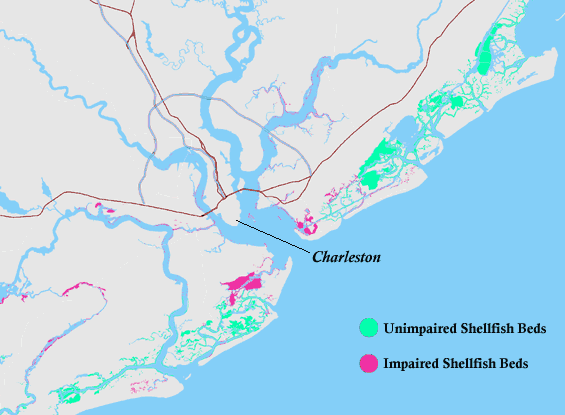
|
Looking at the data in Table VI another way, in 1994 36 percent of the shellfish beds within the urbanized area were impaired, but only 16 percent of those outside the urban area were impaired. Based on this breakdown and the predicted urbanization, by the year 2030 the amount of impaired shellfish beds in urbanized areas could increase by 47 percent, or 846 acres, from 1,779 acres at present to 2,625 acres. Acreage predictions in Table VI for inside the 2030 urban footprint are based on the simple assumption that the relative percentage of impaired vs. unimpaired beds within the urbanized area will remain the same from 1999 to 2030, which is not necessarily true. Further discussion and speculation on how urbanization of the additional 2,336 acres of shellfish beds might affect bed conditions requires more rigorous analysis than is presented here.
The work completed thus far by the Greenbelt Education Project has revealed the following information:
Resources remaining to be inventoried and analyzed include timberland, historic and cultural sites, and land-based environmental resources.
With the exception of the predictive urban growth model, these alarming facts have been revealed through use of already-existing data. A Geographic Information Systems approach has proven to be the ideal method for carrying out the Greenbelt Education Project. It is critical that careful attention be given to how the material is presented. Success of the Greenbelt Education Project will depend on local partners moving the materials into the community discussion. The Greenbelt Education Project has already attracted state-wide and national attention. The graphically stunning maps have been very effective in alerting the public to the possible threat to the Lowcountry's unique and irreplaceable resources.
The following agencies and organizations are acknowledged for their support in providing data for the Greenbelt Education Project:
The South Carolina Coastal Conservation League acknowledges and thanks the Esri Conservation Program (ECP) for the software grant making the Greenbelt Education Project possible.
The Greenbelt Education Project acknowledges the South Carolina Sea Grant Consortium for providing funding to make the first phase of the project possible.
1. From NOAA: "Cultivated Land includes herbaceous (cropland) and woody (orchards, nurseries, vineyards, etc.) cultivated lands. Seasonal spectral signatures, geometric field patterns and road network patterns may help identify this land cover type. Always associated with agricultural land use, cultivated land is used for the production of food and fiber." [return to text]
2. For analysis of all of the Greenbelt Project resource data sets, it was necessary to create an envelope around the urban footprint areas. The reason for this is as follows: The COG study was based on satellite imagery and classified such hard surfaces as roads, parking lots, and roof tops as "urban." The 2030 growth prediction operated on similar conventions. Therefore, features such as cultivated lands, wetlands, creeks, and marshes, which are not hard surfaces, may lie completely within what is considered to be an urbanized area, and it was desired to identify such islands as being impacted by the surrounding urbanization. The urban footprint envelope was created as an ArcView shapefile and converted to a grid for analysis. [return to text]
3. From NOAA: Palustrine Forest "includes all
nontidal wetlands dominated by woody vegetation greater than or equal to 6 meters
in height, and all such wetlands that occur in tidal areas in which salinity
due to ocean-derived salts is below 0.5 parts per thousand (ppt)."
Palustrine Scrub/Shrub "includes all nontidal wetlands dominated by woody
vegetation less than or equal to 6 meters in height, and all such wetlands that
occur in tidal areas in which salinity due to ocean-derived salts is below 0.5
ppt."
Palustrine Emergent Wetland "includes all nontidal wetlands dominated
by trees, shrubs, persistent emergents, emergent mosses, or lichens, and all
such wetlands that occur in tidal areas in which salinity due to ocean-derived
salts is below 0.5 ppt."
"Wetlands are lands where saturation with water is the dominant factor
determining soil development and the types of plant and animal communities living
in the soil and on its surface (Cowardin et al. 1979). A characteristic feature
shared by all wetlands is soil or substrate that is at least periodically saturated
with or covered by water...." [return
to text]
4. A.F. Holland, et al., "The Tidal Creek Project," SC DNR & NOAA (1996). [return to text]
Craig E. Campbell, Ph. D.
Conservation Science and Technology Director
South Carolina Coastal Conservation League
P.O. Box 1765
485 East Bay Street
Charleston, South Carolina 29402
e-mail: craigccl@innova.net
phone: (864) 654-0497
web site: http://www.scccl.org
Charleston office:
phone: (843) 723-8035
fax: (843) 723- 8308
Sam Passmore
Land Use
South Carolina Coastal Conservation League
P.O. Box 1765
485 East Bay Street
Charleston, South Carolina 29402
e-mail: samp@scccl.org
phone: (843) 723-8035
fax: (843) 723- 8308
Jeffrey Allen
Director of Research
South Carolina Water Resources Center
Strom Thurmond Institute for Public Policy
Clemson University
Clemson, South Carolina 29634-0125
e-mail: jeff@strom.clemson.edu
phone: (864) 656-0228
web site: http://www.strom.clemson.edu
also contact:
The Greenbelt Education Project
e-mail: greenbelt@charleston.net
phone: (843) 722-7228
web site: http://www.charleston.net/org/greenbelt/