Using a Geographic Information System to forecast the diffusion of drug misuse
Ken Field, Linda Beale, Heath Heatlie, Martin Frischer
Abstract
Current methods for estimating the incidence, prevalence, and spread of drug misuse tend to be retrospective and are not capable of forecasting spatio-temporal trends. Mapping of drug misuse is therefore restricted to displays of incidence and prevalence rates. This paper details the development of a GIS drug misuse system to create a dynamic model for forecasting and displaying spatio-temporal trends and linking environment with behaviour. It includes a range of parameters to model drug misuse and its geographic spread across a population using data for the United Kingdom as a basis for developing a European-wide forecasting system. The GIS approach reported here provides the basis for examining more complex geographic diffusion scenarios such as the introduction of new practices by new users, the development of education and remedial initiatives, impacts of tourism and migration, cross-border contact, drug transportation, and increasing opportunities for economic and international contact.
Introduction
The problem of drug misuse in the United Kingdom (UK) remained unremarkable until the 1980s when a large increase emerged showing that, by 1994, the proportion of the adult population using drugs at some point during their lifetime had reached 25% (Institute for the Study of Drug Dependence, 1997). Data from the British Crime Survey of 1994 also reveal that 10% of the population have used illicit drugs in the previous year (Ramsay and Spiller, 1997). A similar figure of 9% for previous year illicit drug use is also reported by Anderson and Frischer (1997) for the population of Scotland. There are an estimated 100,000-200,000 severely dependent drug users in the UK (President of the Council, 1998) that creates a massive financial burden. Farrell and Strang (1998) put the cost of such an increase in drug misuse at Ł1.4 billion per year which is further compounded by an estimated Ł3-4 billion resulting from related social problems.
The nature of the large increase in drug misuse and the resulting financial implications have resulted in a number of monitoring initiatives. Studies are in progress throughout the UK (ISDD, 1997) and national crime surveys now routinely require responses to drug related questions (Ramsey and Spiller, 1997). However, one of the major drawbacks of research to date has been the reliance on historical data with many outcomes at best being able only to describe the past. Additionally, much of the data is estimated which produces, at best, unreliable information where the extent of unreliability is unknown. Clearly this information is of little practical use in a policy framework where current and future assessments of key parameters are necessary for improved decision-making. The ability to provide a mechanism to predict changing patterns of drug misuse is therefore a crucial area of research.
There have been several attempts to model drug misuse including the American Drug Abuse Warning Network (DAWN) which monitored drug-related emergency room episodes at a sample of American hospitals (Caulkins, Ebener & McCaffrey, 1995). Also in America, PULSE CHECK reports, derived from qualitative data provided by relevant professionals, provide information on patterns of drug abuse (ONDCP, 1996). An Illicit Drug Reporting System is being developed in Australia (Hando et al., 1998) and, in a European context, the European Monitoring Centre for Drugs and Drug Addiction (EMCDDA) is pursuing a number of initiatives (Hartnoll, 1994; EMCCDA, 1997) to which the research reported here contributes.
Whilst there is much value in attempts to monitor and improve knowledge about patterns of drug misuse many current initiatives still rely on estimates and deliver information about past events. Current methods for estimating incidence and prevalence of drug misuse therefore tend to be retrospective and can only adequately provide data on past events. Crucially, they are not capable of forecasting spatio-temporal trends or, in many instances, consider important geographical characteristics that link location, environment and behaviour. This paper reports preliminary development of a method that can predict the onset and development of future drug misuse epidemics both temporally and spatially. It takes a Geographical Information System (GIS) approach to formulating an effective model which is a departure from previous work in this area. In this sense it draws on the use of GIS to combine geographical factors known to define the spread of drug misuse to create a predictive model and allow map output.
The wide-ranging capability means that GIS provide powerful tools for health and environment based research (Gatrell and Löytönen, 1998). In the area of health care, for example, GIS is being increasingly used for the purposes of needs assessment, resource allocation and service planning (e.g. Bundred et al., 1993; Sillince and Frost, 1993; Todd, et al., 1994; Jones and Bentham, 1995; Love and Lindquist, 1995; Lovett et al., 1998; Field, 2000) and for disease mapping and epidemiological research (e.g. Wing et al., 1990; Rogers and Williams, 1993; Andes and Davis, 1995; Hightower and Klein, 1995; WHO, 1997; Becker et al., 1998). Similarly, GIS are well established in the area of environmental health and epidemiology (Stringer and Haslett, 1991; Gatrell and Naumann, 1992; Briggs and Elliott, 1995; Dunn et al., 1995; Elliott and Briggs, 1998; Briggs and Field, 2000a; 200b). There is currently only one known study that has used a GIS to investigate variations in the frequency and type of drug misuse (Latkin et al., 1998). This study in the city of Baltimore, USA, sampled 597 inner-city injection drug users who were enrolled in a HIV prevention study. The residential locations were plotted using GIS. After adjusting for individual level characteristics and neighbourhood level variables, daily use of cocaine was found to be associated with residing in a more southern area of the city and distance from the western district sexually transmitted disease clinic. In contrast, crack use was found to be associated with residing in a more western area of the city and distance from the western district sexually transmitted disease clinic. The results of this study suggest that type and frequency of drug use is associated with specific geographic areas, independent of neighbourhood characteristics.
In Europe there is increasing recognition that reliable epidemiological information is important for prevention and treatment activities and in recent years there have been renewed efforts to ascertain the level of drug misuse in several countries using a range of methodologies (e.g. IFT 1994; ISDD 1997). In general, methods such as population surveys and capture-recapture analyses provide period prevalence figures and sometimes incidence (Frischer et al., in press), but lack any intrinsic mechanism for forecasting trends in incidence, prevalence or geographical spread. The development of the GIS, reported here, begins to address these limitations and provides a platform to provide:
Drug use diffusion
Pioneering work by Hunt and Chambers (1976) provides an early attempt at modelling drug misuse by focussing on heroin epidemics in the United States in the early 1970s. The main outcomes of this study are that:
There are two main processes that assist an explanation of the spread of heroin use as described by Hunt and Chambers (1976), namely microdiffusion (how use spreads from individual to individual) and macrodiffusion (how use spreads from community to community). Microdiffusion depends on known drug users’ propensity to ‘transmit’ drug use to new users in a similar manner to the spread of an infectious disease with outside users entering a community and initiating use amongst susceptible members. This process might be seen as the first phase in an epidemic of drug misuse (Figure 1).
Figure 1: Incidence and prevalence of drug misuse
in a single community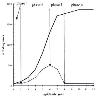 |
This process of diffusion through contact would result in a rapid increase in initial uptake as the number of new users multiplies quickly (phase 2). Increased use would then slow down as the number of susceptibles in the population became exhausted or, in terms of drug misuse, as the number of friends who are prepared to become users in a series of friendship chains diminishes (phase 3). The epidemic then falls to phase 4 indicating a period of stable high endemic use. This epidemic pattern is evident in studies undertaken in Glasgow, Scotland on problematic drug misuse epidemics between 1960-1980 (Ditton and Speirits, 1981; Ditton and Frischer, in press).
In terms of policy initiatives, the key outcome of an understanding of the pattern of an epidemic is in the ability to understand which phase of an epidemic a particular community is in. Crucially, the policy response to increased drug misuse in a community may differ, dependent upon the epidemic phase exhibited. For instance, the management of a population that includes a growing number of relatively new users would differ significantly to that which would handle a large number of long-term stable users.
The process of microdiffusion only adequately describes the development of drug misuse within a single community. Macrodiffusion, on the other hand, relates to the movement of misuse between geographical areas and occurs in the same manner as the geographical spread of other new phenomena. The modelling of spatial diffusion characterises a key area of geographical inquiry stemming from early investigations into the spread of the El Tor strain of cholera from its origins outside Mecca in 1905 and the Celebes in the 1930s, commonly referred to as the seventh of the world's great cholera outbreaks. Such examples illustrate an explicit geography, an investigation of which might yield insights into spatial diffusion processes. In theoretical terms, most geographical interest in diffusion studies originates from the work of Torsten Hägerstrand (1953) which was concerned with the spread of agricultural innovations. The diffusion process can take many forms, namely relocation, hierarchic, cascade and contagious and operates as a wave in both profile and in time and space. The profile of a diffusion wave illustrates the passage of the process studied in relation to the rate of progress and distance from the point of origin. The shape of diffusions in space and time can be examined by creating trend surface maps which the American geographer Richard Morrill did when fitting generalized contour maps to Hägerstrand's Swedish data. In the first instance a diffusion wave has limited height that represents limited uptake or acceptance. The wave subsequently increases in both height and extent and then decreases in height but increases in spatial extent as time elapses. A weakening of the wave over space and time emerges since the wave is time-dependent (as a profile diminishes) and space-dependent (as the wave encounters barriers of some sort). Waves may also speed up or slow down over geographical space dependent on such factors as interconnectivity and, where two waves originate from centres in close proximity, they may mingle and lose identity as the merge with competing waves. As noted, diffusion models have long been applied to the control of disease epidemic waves. The work reported here draws upon the theoretical aspects of spatial diffusion and their application to the control of disease epidemics (e.g. Cliff et al. 1993, Haggett, 2000)
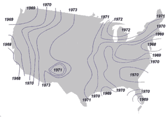
In terms of drug misuse, Hunt and Chambers (1976) noted that different places in the USA were impacted by new heroin use at different times. This clearly indicates that the onset of an epidemic across a geographical area differs temporally in relation to the first community epidemic. The main factor underpinning the sequence of heroin epidemics in America was that of declining population density: that heroin use spreads from larger to smaller settlements. Figure 2 illustrates that heroin use appears to have begun on the North East Coast along the chain of cities from Boston to Washington, and in Southern California. Large inland and Gulf coast cities were also early centres of epidemic use. From these continental margins, heroin use moved to the interior spreading sequentially from cities in regions of high population density to those of lower density following the principle of wave diffusion from multiple centres (Morril, 1970).
|
Figure 2: Isochrony of peak heroin use in the United States, 1968-1973 (adapted from Hunt and Chambers, 1976)
|
Clearly then, if the components of microdiffusion and macrodiffusion are combined with data on the distribution of the population for a given area then it is possible to develop a rudimentary model that can predict the diffusion of drug misuse. The remainder of this paper details the development of such a model with GIS being ideally suited to displaying and analysing drug misuse based on the explicit geographies involved in the diffusion process.
Developing the GIS based Drug Incidence and Prevalence Estimation Program (DIPEP)
The Drug Incidence & Prevalence Estimation Program (DIPEP) is designed to predict incidence and prevalence of drug misuse. It is based on the assumption that drug misuse spreads in a similar manner to infectious diseases and that this can be effectively modelled by considering the processes of microdiffusion and macrodiffusion. Moreover, in terms of drug misuse, only a certain proportion of the population is susceptible (peak prevalence) which means that the epidemic will have a life cycle that ends when the number of potential drug users is exhausted.
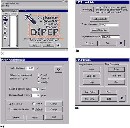
The program has undergone a number of developments over the past few years from its beginnings as a Turbo Pascal program, limited to pre-set parameters, through the development of a Microsoft Excel version and, as reported here, a version within a GIS framework. Both the initial versions did not allow geographical dimensions to be adequately modelled and suffered from a lack of user control. The GIS based version has been prepared as an Avenue script to create an application that runs in ArcView (Figure 3).
|
Figure 3: Components of the DIPEP application in ArcView GIS
|
Upon launch (Figure 3a), DIPEP requires the user to input information that defines the location of spatial and attribute data files via a series of buttons and text entry forms (Figure 3b). The spatial data can be either an Arc/Info coverage or an ArcView shapefile and provides the geographical component necessary for subsequent mapping of the spread of drug misuse. Attribute data can be in INFO or DBF format. The attribute data contains an item of data that will be used by DIPEP to calculate diffusion of drug misuse. This will normally be a list of population values corresponding to the points or areas defined by the spatial data. At this stage DIPEP requires the user to enter the name of the item that is common to the table of the ArcView theme as well as the attribute data (atlas_p in Figure 3b). Once DIPEP has calculated the diffusion outcome for the loaded data, the common item name is used to link the DIPEP results to the ArcView theme to provide map output. Additionally, DIPEP needs to know which item in the attribute data which holds the data to be used in the DIPEP calculations (population in Figure 3b).
Once this initial information is defined, DIPEP allows the user to determine the values used by the parameters of the diffusion model, summarised in Table 1 and which are entered via the dialog box illustrated in Figure 3c.
Table 1: DIPEP parameters
|
Parameter number |
Parameter description |
Input values (user controlled) |
|
1 |
Estimated peak prevalence |
0-100% (default = 0.61%) |
|
2 |
Diffusion lag |
annual, bi-annual, monthly (default = annual) |
|
3 |
Length of epidemic cycle |
unlimited (default = 30 units of time defined by diffusion lag) |
|
4 |
Duration of addict career |
unlimited (default = 10 units of time defined by diffusion lag and must be less than length of epidemic cycle) |
|
5 |
Epidemic curve |
user defined (default = 1, 2, 4, 8, 10, 8, 1, 1 etc.) |
|
6 |
Population classification |
alternative classification methods for population data (default = 15 classes) |
Estimated peak prevalence is the peak amount of drug usage exhibited in a population, expressed as a percentage of the total population. This reflects the maximum number of susceptibles in a given community. The diffusion lag models the rate of spread of drug use between areas or points (depending on the feature type loaded). Periodicity is variable dependent on the purpose for which DIPEP is being used. For instance, it may be that misuse of certain drugs are known to diffuse at different rates and this option allows a measure of speed of diffusion to be considered. Length of epidemic cycle is the time period that defines the length of the drug use epidemic in a community from initial use to a post-epidemic, endemic, phase. The length of time of drug use by an individual is modelled by the duration of addict career parameter. The value must be lower than the value of the epidemic cycle and represents the average length of time of use of a drug by an individual.
The default distribution of the epidemic curve follows the pattern shown in Figure 1 resulting in a drug misuse epidemic that is negatively skewed and which is characterised by steep initial phases, a decelerating phase of increase followed by a plateau and steady reducing phase. Under the default option, once an epidemic has ceased, the number of incident cases reduces to zero and drug misuse will persist in an endemic phase for the remainder of the cycle. In DIPEP the epidemic curve can be varied according to a user defined distribution entered as a series of numbers (in an ArcView table) that reflect the shape of the epidemic’s distribution in a single community. During calculation, DIPEP uses the epidemic curve to determine the incidence of new drug use in a given community at each stage of the epidemic cycle.
The final parameter, population classification, gives the user a method of range-grading the population data supplied in the attribute data file. The principle behind DIPEP is that drug misuse will move from the largest settlements in a given area to progressively smaller settlements. It is necessary to range-grade data so that settlements with similar population sizes will be modelled as experiencing initial drug misuse at the same time as the diffusion spreads. This also takes some account of interconnectedness of settlements since larger settlements are likely to have better communications networks and increased levels of population movement than smaller settlements. Several options are available that reflect different population distributions and an option exists to enter a user defined classification.
Once the population classification is defined, DIPEP returns summary statistical data for the item of data used in the calculations as well as a histogram of the population distribution to provide a visual check that the population classification employed is appropriate. The default values for DIPEP parameters have been determined from a range of sources to accurately reflect the known characteristics of drug misuse epidemics as reported extensively in Ditton and Frischer (2001).
Pressing the continue button on the parameter input dialog box (Figure 3c) initiates the DIPEP diffusion model. Based on the peak prevalence, length of epidemic cycle and duration of addict career DIPEP calculates the incidence of drug misuse at each stage of the epidemic according to the epidemic curve (modelling microdiffusion). These calculations are made for each settlement in the spatial database. DIPEP then models the spread of misuse between settlements according to the diffusion lag, modifying incidence and prevalence at each subsequent time period according to the epidemic curve (modelling macrodiffusion). DIPEP prepares and reports the outcome of incidence and prevalence calculations in separate tables which can then be visualised in a view via a further dialog box (Figure 3d).
Tables for both incidence and prevalence are constructed to show population categories as ‘fields’ and time periods as ‘records’ in an ArcView table. From this, the pattern of drug misuse can be viewed for each classified population category. Each cell in the table reports the total incidence (or prevalence) of drug misuse for the population of all settlements classified in a particular category at a given time during the epidemic. This data can be graphed to provide a more appropriate form of visualisation of the data. However, it must be noted that the chart options in ArcView (version 3.2) are not powerful enough to display all the data as a single graph. Instead, tabular data must be exported and graphs prepared using alternative software. Figure 4 shows ncidence and prevalence for towns and cities in the UK, classified into 15 categories of settlement size, and using default parameters.
Figure 4 Incidence and prevalence of problematic drug misuse graph for UK
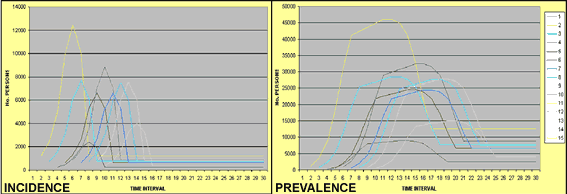
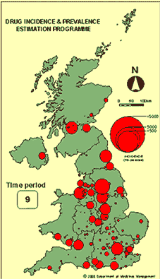
The graphs indicate the shape of the epidemic, its impact in terms of incidence and prevalence per population category and the spread from large settlements to smaller ones across a 30 year epidemic cycle. The spatial dimension of drug diffusion is visualised by joining the tabular data generated by DIPEP to the spatial database of the themes imported into ArcView. The process requires the aggregated data reported in the tabular output (i.e. total incidence or prevalence is reported per population category) to be disaggregated and data assigned to each settlement in the theme for each time period modelled. This generates a dataset that is joined to the themes attribute table giving incidence and prevalence data, per time period, as fields. This information can subsequently be mapped using the usual variety of map output selected by the user. Part of the incidence data reported in Figure 4 is also illustrated in Figure 5 in map form where ArcView was used to create graduated symbols illustrating incidence for each settlement in the database.
|
Figure 5: Projected incidence of problematic drug misuse (UK) – Year 9 of epidemic cycle
|
The full impact of the output from DIPEP can only be seen when maps are derived for each stage of the epidemic cycle and then stitched together to form a sequence of maps that illustrate the spatial patterning of the wave-like diffusion process through time. The animated map sequence is available to view at the DIPEP web site (Figure 5). The animated sequence of maps cycles through the various time periods modelled by DIPEP and clearly illustrates the way in which the predicted problematic drug misuse epidemic might spread throughout the UK after initial use in the largest settlement (London). This models the predicted spread of a new problematic drug misuse epidemic as suggested by recent research (Parker, 1998). Given Parker (1998) reports the periodicity of problematic drug misuse epidemics as being 20 years, and the last major epidemic to affect the UK began in the late 1970s, DIPEP projects the spread of a new epidemic that is just becoming evident in real terms.
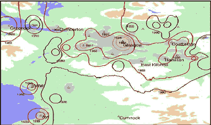
Using datasets on drug misuse in Glasgow for 1980-1995 (Ditton and Frischer, 2001) it has been possible - with hindsight - to assess the accuracy of the outcomes of DIPEP in relation to data derived from capture-recapture studies of injecting drug use. Drug misuse initially centred around Glasgow (1980). There was a dramatic rise in user’s from 1980-1985 with drug misuse quickly spread to the surrounding urban areas in 1988. The isolines indicate that at this time drug misuse began in the distant population centres of Greenock, Irvine and Ayr. Figure 6 illustrates the change in drug use incidence with the epidemic cycle of the model determining that new cases reach their lowest level in 1995.
|
Figure 6: Isochrony of Scottish drug misuse (after Ditton and Frischer, 2001)
|
This map takes a different form of visualisation and makes use of the contour creation tool in the spatial analyst add-on for ArcView. Using point based data output from DIPEP it was possible to create a series of contour maps for each time period and to then merge map output. This has the advantage over the graduated symbol map type in that it can represent population as a continuous surface (albeit one derived from point based data) and better illustrate waves of diffusion. Clearly though these maps require careful interpretation since it would be inappropriate to attribute meaning to areas where a high degree of interpolation has taken place (i.e. where data points are far apart, perhaps reflecting sparsely populated rural environments).
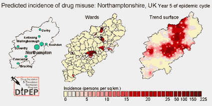
DIPEP has also been used to model the potential introduction of drug misuse to a single county in the UK. Northamptonshire, in the East Midlands, is a county that displays wide variations reflecting the fact that people and households with particular characteristics are very concentrated in particular areas. Detailed information on the population of the UK is collected every 10 years by means of a national census. The most recent data currently available on the whole population is from the 1991 census (the 2001 census has recently been completed but data will not be available until 2003/3) and this provides the population information for Northamptonshire. The county covers an area of 2,367 sq. km. with an overall population of 578,807. Data from the census is reported at a range of different scales with each subsequent scale comprising areas constructed by aggregating data reported at a larger scale. The most appropriate scale to use when reporting DIPEP results at County level is ward level analysis. There are 148 wards in Northamptonshire exhibiting population densities of between 17 and 6655 persons per sq. km. The distribution of the population itself is uneven with population densities in some urban areas being nearly 400 times that of many rural areas. There is remarkable consistency in patterns for a range of socio-economic variables which regularly show sharp differences between the main towns and rural areas and striking differences within towns (NCC, 1995). Furthermore, it is the same areas that consistently tend to figure as those with high (or low) values for many socio-demographic characteristics.
Population density was used as opposed to population totals in the DIPEP model to take account of the problems associated with reporting output in map form where data are aggregated and displayed in administrative boundaries (thus taking into account the effect of ward size in relation to population). Alternative maps have been produced to provide different methods of visualising the output from DIPEP (Figure 7).
|
Figure 7: Projected drug misuse incidence, Northamptonshire, UK
|
As with Figure 5, the maps illustrate a slice through time and animated versions are available to view at the DIPEP web site (Figure 7a;Figure 7b). The ward based maps illustrate the overall low levels of drug misuse at all stages of the epidemic cycle in much of Northamptonshire. Since population densities in many areas are low, with a peak prevalence of 0.61%, it is unlikely that such areas will experience drug misuse. However, a different picture emerges for the county town of Northampton and other towns such as Corby, Kettering and Wellingborough. At the peak of the epidemic parts of Northampton are predicted to have up to 224 problematic drug users per sq. km. This information would be appropriate in a policy arena where local targetting of attempts to minimise drug misuse might be implemented. The trend surface map is similar in creation to those that are commonly used to report the spatial diffusion process of disease epidemics (Cliff and Haggett, 1988; Smallman-Raynor et al. 1992; Gould, 1993) and was created using ArcView Spatial Analyst. The animated version of the maps show the wave-like diffusion of drug misuse from initial use in parts of Northampton, Corby and Wellingborough and moving outwards across the county before subsiding. In many ways this map could be considered as illustrating a more accurate picture of the spatio-temporal characteristics of drug misuse, when compared to the ward based map, since populations are distributed continuously across space. Whilst the ward based map is a common method of reporting population data it masks many of the important wave characteristics and constrains DIPEP results to arbitrarily defined census boundaries. Indeed, closer examination of the surface maps at different time periods shows how waves of diffusion of problematic drug misuse are modified as they come into contact with a wave that emanated from a different initial settlement. In this sense, populations in between settlements that experience drug misuse in the early stages of an epidemic actually become affected from more than one direction. The trend surface maps do suggest a more complex interpretation of the movement of an epidemic across geographical space than that which is inferred by the ward based map.
Conclusions
While mapping of drug diffusion is currently rudimentary, the pioneering work of Hunt and Chambers (1976) provides a basic framework for developing a GIS approach to modelling drug misuse. The development of DIPEP within a GIS framework is an initial attempt to model the process of drug misuse diffusion but it is acknowledged that more development is needed to incorporate many of the confounding factors that impact upon spatial diffusion processes.
Notwithstanding the need for further conceptual developments, the flexibility afforded by the Avenue and ArcView development environment has resulted in a powerful application that allows variation in the parameters that underpin the micro and macro-diffusion processes. The DIPEP application is a fully portable project with all required scripts being automatically loaded. At each stage of the program the code checks, before carrying out a function, that all the data is present and in the correct format for such a function. Entry error is minimised via this checking process and in cases where, for example, the ‘common item name’ is not present in both datasets then a pop-up message box will inform the user of erroneous input. These features reduce user frustration obtained with unstable programs, allow less confident users to use it and enables the user, through information, to solve problems. Additionally, within each dialog box is a fully integrated help facility that explains both the operation of DIPEP and the specific requirements of the user controlled data and parameter entry.
However, developing a more robust GIS application that is useful for policy formulation is the next challenge and will require careful consideration of several issues. With hidden populations, such as drug users, the sampling frame is unknown, in view of this a number of indirect prevalence estimation techniques have been developed which provide the predictive parameters used currently in DIPEP. These methods have depended upon collecting data from sources with information on known drug users and constructing a model to project the unknown outcome. Whilst the predictive capability of DIPEP works retrospectively, in that it can accurately model known epidemics from the past, it is clear that more testing needs to be undertaken to examine DIPEP in relation to current drug user behaviour. In order to predict drug use trends it is necessary to understand the factors that influence people’s decision to use drugs. Concepts such as personal freedom are not easily quantified; on the other hand drug use has been linked to a range of interpersonal and environmental factors (Ramsey & Percy, 1996). For example with increasing personal freedom and scope for travel within Europe there has been speculation that opportunities will arise for new forms of drug trafficking and drug use (Dorn & White, 1994). This has already occurred in the European part of the former Soviet Union (Lee, 1992) as a consequence of the social and economic changes which have occurred since the mid-1980s. However there are few data from this region with which to paint a reliable picture of current prevalence of drug misuse.
Whilst DIPEP incorporates a range of parameters that reflect drug diffusion there may well be more diverse mechanisms to consider: the introduction of new practices by new users; tourism and migration; cross-border contact; drug transportation via alternative communication networks; and increasing opportunities for economic and international contact are all potentially important factors. Furthermore, drug misuse may be distributed throughout a region according to particular socio-economic conditions; for instance, it may be concentrated in economically deprived neighbourhoods and it may be necessary to apply a weighting factor to settlements, based on the levels of deprivation experienced, when calculating incidence and prevalence.
One important proposed development of DIPEP is to examine the impact of interventions in the diffusion process. Such interventions may reflect improved education programmes in public health or might model the impact of remedial actions such as the impact of providing free syringes or controlled prescription. Proposed policy interventions would therefore be able to be modelled to discern the potential impact before a financial commitment is made.
What is clear is that GIS offers a dynamic and flexible approach to visualising the drug diffusion process and an environment where development of DIPEP can be taken forward to model complex spatio-temporal diffusion processes. The work reported in this paper is going some way to addressing current concerns about monitoring increased drug misuse and forecasting future trends within the European Union.
Acknowledgements
Financial support for this project has been provided by the European Monitoring Centre for Drugs and Drug Addiction
References
Anderson, S. and Frischer, M (1997) Drug misuse in Scotland: findings from the 1993 and 1996 Scottish crime surveys. Edinburgh: Scottish Office Central Research Unit
Andes, N. and Davis, J.E. (1995) Linking public health data using geographic information system techniques: Alaskan community characteristics and infant mortality. Statistics in Medicine. 14, 5-7, 481-90
Becker, K.M., Glass, G.E., Brathwaite, W., Zenilman, J.M. (1998) Geographic epidemiology of gonorrhea in Baltimore, Maryland, using a Geographic Information System, American Journal of Epidemiology, 147, 7, 709-716
Briggs, D. J. and Elliott, P. (1995) GIS methods for the analysis of relationships between environment and health. World Health Statistics Quarterly, 48, 85-94
Briggs, D. J. and Field, K. S. (2000a) Using GIS to link environment and health data. In Decision-making in environmental health: From evidence to action, (eds) Corvalan, C., Briggs, D., Zielhuis, G. London: Routledge, E&FN Spon
Briggs,D. J. and Field K. S. (2000b) Informing environmental health policy in urban areas: The HEADLAMP approach, Reviews on Environmental Health, 15, (1-2), 169-186
Bundred, P., Hirschfield, A. and Marsden, J. (1993) GIS in the planning of health services in a District Health Authority. Proceedings of the AGI conference 1993, AGI: London
Caulkins, J., Ebener, P. and McCaffrey, D. (1995) Describing DAWN’s domination, Contemporary Drug Problems, 22, 547-567
Cliff, A. D., Haggett, P. and Smallman-Raynor, M. (1993) Measles: an historical geography of a major human viral disease. Oxford: Blackwell
Cliff, A. D. and Haggett, P (1988) Atlas of disease distributions: analytical approaches to disease data. Oxford: Blackwell
Ditton, J. and Speirits, K. (1981) The rapid increase of heroin addiction in Glasgow during 1981, Background paper Two, Glasgow University
Ditton, J. and Frischer, M (2001) Computerised projection of future heroin epidemics: a necessity for the 21st century? Journal of Substance Use and Abuse. 36, 1-2, 151-66
Dorn, N. and White, S. (1994) European Free Movement, Drug Users and Access to Health Services. International Journal of Drug Policy 5, 35-44.
Dunn, C. E., Woodhouse, J., Bhopal, R. S. and Acquilla, S. D. (1995) Asthma and factory emissions in northern England: addressing public concern by combining geographical and epidemiological methods. Journal of Epidemiology and Community Health, 49, 395-400
Elliott, P. and Briggs, D. J. (1998) Recent developments in the geographical analysis of small area health and environmental data. In G. Scally [ed.] Progress in Public Health. FT Healthcare, 101-25
European Monitoring Centre for Drugs and Drug Addiction (1997) Annual report on the state of the drugs problem in Europe. EMCDDA: Lisbon
Farrell, M. and Strang, J. (1998) Britain’s new strategy for tackling drug misuse, British Medical Journal, 316, 1399-1400
Field, K. S. (2000) Measuring need for primary health care: an index of relative disadvantage, Applied Geography, 20 (4) 305-335
Gatrell, A. and Naumann, I. (1992) Hospital location planning: a pilot GIS study. Unpublished report, North West Regional Research Laboratory, Lancaster University
Gatrell, A. and Löytönen, M. (1998) GIS and health. GISData 6, London: Taylor and Francis
Glass, G.E., Schwartz, B.S., Morgan, J.M., Johnson, D.T., Noy, P.M. and Israel, E. (1995) Environmental risk factors for Lyme disease identified with geographic information systems, American Journal of Public Health, 85, 7, 944-948
Gould, P. (1993) The slow plague: a geography of the AIDS pandemic, Oxford: Blackwell
Hägerstrand, T. (1953) Spatial diffusion as an innovation process, University of Lund: Sweden
Haggett, P. (2000) The geographical structures of epidemics, Clarendon Press: Oxford
Hightower, A.W. and Klein, R.E. (1995) Building a geographic information system (GIS) public health infrastructure for research and control of tropical diseases, Emerging Infectious Diseases. 1, 4, 156-7
Hando, J., Flaherty, B. and Rutter, S. (1998) An Australian profile on the use of cocaine, Addiction, Feb 1997, Vol.92, No.2, pp.173-182
Hartnoll, R (1994) Multi-city study: drug misuse and trends in thirteen European cities, Council of Europe: Strasbourg
Hunt, L. and Chambers, C. (1976) The heroin epidemics: a study of heroin use in the United States, 1965-75. Spectrum: New York
Institut fur Therapieforschung. (1994) Report on the methods of estimating the extent of the drug problems in Germany. IFT: Munich.
Institute for the Study of Drug Dependence (1997) Drug misuse in Britain, 1996, ISDD: London
Jones, A. P. and Bentham, G. (1995) Emergency medical service accessibility and outcome from road traffic accidents. Public Health, 109, 169-177
Kitron, U., Michael, J., Swanson, J. and Haramis, L. (1997) Spatial analysis of the distribution of LaCrosse encephalitis in Illinois, using a geographic information system and local and global spatial statistics. American Journal of Tropical Medicine and Hygiene, 57, 4, 469-475
Latkin, C., Glass, G. E. and Duncan, T. (1998) Using geographic information systems to assess spatial patterns of drug use, selection bias and attrition among a sample of injection drug users, Drug Alcohol Dependence. 50, 2, 167-175
Lee, R. W. (1992) Dynamics of the Soviet illicit drug market. Crime, Law and Social Change 17, 3, 177-233.
Love, D. and Lindquist, P. (1995) Geographic accessibility of hospitals to the aged. Health Services Research, 29, 6, 629-651
Lovett, A., Haynes, R., Bentham, G., Gale, S., Brainard, J. and Suennenberg, G. (1998) Improving health needs assessment using patient register information in a GIS. In A. A. Gatrell and M. Löytönen [Eds.] GIS and health. GISData 6, London: Taylor and Francis, 191-203
Morrill, R. L. (1970) The spatial organisation of society, Wadsworth, Belmont USA
Northamptonshire County Council (1995) 1991 census atlas of Northamptonshire. Northampton: Northamptonshire County Council, Policy Division
Office of National Drug Centre Policy (1996) Pulse Check: national trends in drug abuse, Executive Office of the President: Washington
Parker, H. (1998) New heroin outbreaks amongst young people in England and Wales, Research and Statistics Directorate, Home Office: London
President of the Council (1998) - President of the Council. Tackling drugs to build a better Britain. The government's ten year strategy for tackling drugs misuse. The Stationery Office: London
Ramsay, M. and Percy, A. (1996) Drug misuse declared: results of the 1994 British Crime Survey. Home Office: London
Ramsay, M. and Spiller, J. (1997) Drug misuse declared in 1996: latest results from the British Crime Survey. Home Office: London
Rogers, D. J. and Williams, B. G. (1993) Monitoring trypanosomiasis in space and time. Parasitology, 106, Suppl S77-92
Sillince, J. A. A. and Frost, C. E. B. (1993) Management information systems in UK primary health care: the need for a strategy. International Journal of Information Managament, 13, 425-437
Smallman-Raynor, M., Cliff, A. and Haggett, P. (1992) Atlas of AIDS, Blackwell: Oxford
Smith, P. G. and Hayes, R. J. (1998) An analysis of the geographical distribution of severe malaria in children in Kilifi District, Kenya, International Journal of Epidemiology, 27, 2, 323-329
Stringer, P. and Haslett, J. (1991) Exploratory, interactive analysis of spatial data: an illustration of the area of health inequalities. Unpublished report. Northern Ireland Regional Research Laboratory, Trinity College: Dublin
Todd, P., Bundred, P. and Brown, P. (1994) The demography of demand for oncology services: a health care planning GIS application. In Proceedings of the AGI conference 1994. AGI: London
Wing, S., Casper, M., Davis, W., Hayes, C., Riggan, W. and Tyroler, H. A. (1990) Trends in the geographic inequality of cardiovascular disease mortality in the United States, 1962-1982, Social Science and Medicine. 30, 3, 261-266
World Health Organisation (1997) Atlas of mortality in Europe: subnational patterns 1980/81 and 1990/91. WHO Regional Publications, European Series No. 75, WHO: Geneva
Author information
|
Ken
Field BSc PhD |
Heath
Heatlie BSc MSc |