Abstract
Fire has historically been an important ecological factor maintaining southeastern vegetation. Humans have altered natural fire regimes by fragmenting fuels,
introducing exotic species, and suppressing fires. Little is known about how these alterations affect spatial fire spread and its behavior through time.
To quantify the difference between historic and current fire spread distributions, we used ARC/INFO and the FARSITE fire spread model.
We held all variables constant with exception of the fuel models representing different time periods. Fires during the early 1900’s burned freely across
the landscape, while current fires are much smaller, restricted by human-created barriers.
Introduction
Florida’s dominant terrestrial vegetation communities (scrub and flatwoods) are dependent on, and adapted to, frequent fire (Abrahamson 1984, Myers 1990). Historically frequent fires were ignited by growing season lightning strikes, maintaining vegetation composition and structure (Robbins and Myers 1989, Duncan et al. 1999). Human influences such as fire suppression, fragmentation, and proliferation of exotic vegetation have greatly altered fuels disrupting natural fire regimes (Myers and White 1987, Duncan et al. 1999).
To understand the effects of anthropogenic change on spatial fire behavior, we modeled historic and current fire spread across Kennedy Space Center (KSC)/Merritt Island National Wildlife Refuge (MINWR), Florida. During the modeling we held all variables constant with exception of the fuels, which represented different time periods. This approach isolated the differences between natural and anthropogenic fuel conditions providing valuable perspective on baseline burning conditions for land managers.
Study site
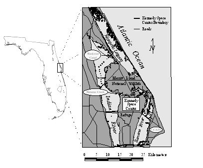
KSC/MINWR comprises 57,000 ha in Breavard and Volusia counties located along the east coast of central Florida (Figure 1). KSC/MINWR occupies a barrier island complex comprised of a diverse assemblage of fire-adapted terrestrial vegetative communities. Upland xeric sites are dominated by oak scrub vegetation (Quercus spp.), while mesic sites are dominated by flatwoods (e.g., Serenoa repens, Lyonia spp., Ilex sp., and overstory of Pinus elliotii) (Schmalzer and Hinkle 1992). Because the landscape is comprised of relict dunes forming ridge swale topography (total relief of 1 to 3 meters), there are interleaving swale marshes and hammocks on hydric soils between the xeric ridges. The swales are dominated by Spartina bakeri and Andropogon spp. while the hardwood hammocks are dominated by Quercus virginiana and Quercus laurifolia that have a structure that is much less flammable than surrounding communities.

Methods
We used the Fire Area Simulation model (FARSITE) version 3.0 (SEM 2001) for all spatial fire modeling with input directly from ARC/INFO GRID software (Esri 2000). We were interested in anthropogenic features and their impact on fire so we modeled the landscape at 10 meter resolution to include linear features created by man. To increase modeling efficiency at this resolution, we split the study area into north, central, and south regions by using natural geographic barriers to fire.
We converted 1920, 1943, and 1990 landcover maps (Duncan et al. 2000, Duncan et al. 2001 in review) into fuel models by assigning each landcover type to a BEHAVE fire model class (FARSITE online documentation). Freshwater marshes were assigned to Fire Behavior Model 1 (Anderson 1982). Disturbed freshwater marshes were assigned to Fire Behavior Model 2, while oak scrub and flatwoods communities were assigned to Fire Behavior Model 7. Hammocks, mixed hardwoods, and wetland hardwoods were assigned to Fire Behavior Model 8, and categories associated with water were assigned to Fire Behavior Model 98. The fuel models were then converted to grid coverages for input into FARSITE.
To complete the spatial data requirements for the model, we created an elevation grid, a slope grid, an aspect grid, and a canopy coverage grid. The elevation grid was given an elevation of three meters for the entire study site, while the slope and aspect layers were assigned a value of zero degrees. Slope and aspect may influence fire behavior but due to the subtle relief of KSC/MINWR there were no digital elevation models available to help simulate these variables. The north and south canopy coverage layers were generated with model 1 having 7% canopy coverage, model 2 and model 7 having 15% canopy coverage and model 8 having 100%, and model 98 having no canopy coverage. The central region of KSC/MINWR is dominated by scrub vegetation communities with very little pine canopy so the canopy cover values were 3%, 7%, 100%, and 0%, respectively.
Meteorological inputs were gathered using KSC’s network of meteorologic towers and collection sites. We selected July 20th through 27th 1999 for our modeling window, because it was representative of typical meteorologic conditions during the summer when lightning strike probabilities were high. The model requires daily inputs for precipitation, hour of minimum temperature, hour of maximum temperature, minimum temperature, maximum temperature, minimum humidity, maximum humidity, and elevation of meteorlogical collection site.
Wind data are required on an hourly basis with wind speed, wind direction, and cloud cover data all being required by the model. The last remaining required input to the model is initial fuel moistures. These are input in percent for each fuel model as 1-hour fuel moistures, 10-hour, 100-hour, live herbaceous, and live woody fuels.
We selected our ignition point for a simulated lightning strike and began our fire simulations. We held the location of ignition and all model inputs constant with exception of the fuel models represented different time periods and varying levels of anthropogenic disturbance of fuels.
Results
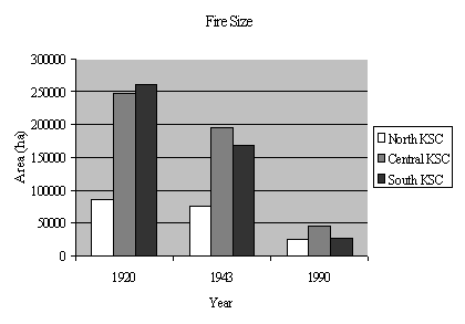
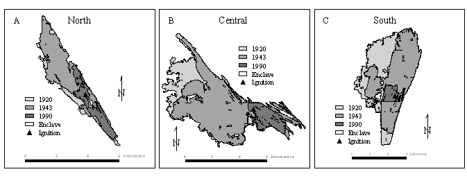
The largest simulated fires occurred in 1920 and fires became smaller for each successive modeling date (Figure 2). The largest decreases in fire size occurred between 1943 and 1990 for all regions of study. In the northern region, 85,151 hectares burned in 1920 with 88% (75,535 ha) of that burning in 1943 and 28% (24,579 ha) burning in 1990. In the central region, 247,769 hectares burned in 1920 with 78% (195,592 ha) of that burning in 1943 and 18% (45,328 ha) burning in 1990. In the southern region, 260,672 hectares burned in 1920 with 64% (167,380 ha) of that burning in 1943 and 10% (26,314 ha) burning in 1990.


Discussion and Conclusion
Anthropogenic influences have affected fuel continuities and flammability, causing a reduction in fire extent. The simulations show that in 1920, fires would burn until the fuels were either exhausted or meteorologic conditions became unfavorable. In 1943, fires began to be confined by anthropogenic features on the landscape and were even more restricted by these features in 1990. Fragmentation, however, is not the only anthropogenic obstacle for fire. Past fire suppression policies have altered landcover and hence fuels, in several ways. The absence of fire in this fire maintained ecosystem has allowed scrub to grow to un-natural heights, excluding fire in all but the most extreme meteorologic conditions. Exotic and hardwood species invasion of swale marshes have increased with fire suppression policies, reducing flammability across the KSC/MINWR landscape. For a more complete discussion of anthropogenic impacts on the KSC/MINWR landscape, see Duncan et al. (1999).
The results presented here help to quantify anthropogenic effects on fire behavior. The fires simulated on the relatively natural 1920 landscape burned freely until fuels or meteorologic condition became unfavorable. The 1943 and 1990 simulations show that fires have become much less governed by natural variables, such as fuels and meteorologic conditions, but rather by human imposed barriers.
Acknowledgements
This study was conducted under NASA contract NAS10-12180. We thank Burton Summerfield from the NASA KSC Safety Occupational Health and Environment Branch of the Safety Occupational Health and Environment Directorate and Dr. W.M. Knot, III from the NASA KSC Biological Sciences Branch of the Spaceport Engineering and Technology Directorate for their assistance and support.
References
Abrahamson, W.G. 1984. Post-fire recovery of Florida Lake Wales Ridge vegetation. American Journal of Botany 71:9-21.
Anderson, H.E. 1982. Aids to determining fuel models for estimating fire behavior. Intermountain Forest and range Experiment Station Ogden, UT. General Technical Report INT-122. 22 pp.
Duncan, B.W., S. Boyle, D.R. Breininger, and P.A. Schmalzer. 1999. Coupling past management practice and historic landscape change on John F. Kennedy Space Center, Florida. Landscape Ecology 14:291-309.
Duncan, B.W., V.L. Larson, and P.A. Schmalzer. 2000. Modeling Historic Landcover: An Evaluation of Two Methodologies for Producing Base Line Reference Data. Natural Areas Journal 20:308-316.
Duncan, B.W., V.L. Larson, and P.A. Schmalzer. 2001. Historic landcover and recent landscape change in the north Indian River Lagoon watershed, Florida. Submitted to Natural Areas Journal.
Esri. 2001. ARC/INFO online documentation.
Myers, R.L. 1990. Scrub and high pine. Pp. 150-193 in Myers, R.L. and J.J. Ewel eds. Ecosystems of Florida. University of Central Florida Press, Orlando. 765 pp.
Myers, R.L. and D.L. White. 1987. Landscape history and changes in sandhill vegetation in North-Central and South-Central Florida. Bulletin of the Torrey Botanical Club 114:21-32.
Robbins, L.E. and R. L. Myers. 1989. Seasonal Effects of Prescribed Burning in Florida: A Review. The Nature Conservency, Tallahassee, FL. 119 p.
Schmalzer, P.A. and C.R. Hinkle. 1992. Recovery of oak-saw palmetto scrub after fire. Castanea 57:158-173.
Systems for Environmental Management (SEM). 2001. FARSITE Home Page. www.montana.com/sem/public_html/farsite.html.
Author Information
Brean W. Duncan
Physical Geographer
Dynamac Corporation
NASA Biological Sciences Branch
Mail Code: DYN-2
Kennedy Space Center, Florida 32899
Telephone (321) 476-4122
Fax: (321) 853-2939
Email:duncabw@kscems.ksc.nasa.gov
Paul A. Schmalzer
Plant Ecologist
Dynamac Corporation
NASA Biological Sciences Branch
Mail Code: DYN-2
Kennedy Space Center, Florida 32899
Telephone (321) 476-4112
Fax: (321) 853-2939
Email: schmapa@kscems.ksc.nasa.gov