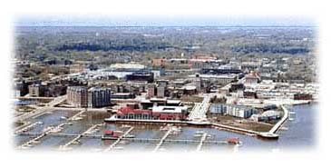
Figure 1. City of Racine, Wisconsin USA
Paul Sommers
Mr. Jones, Commissioner of Public Works, after years of blood, sweat and tears from GIS conversion, had to demonstrate a higher return on investment.His Intranet GIS Casual User Interface, developed with ArcIMS® and MrSID® technologies, was just what the doctor ordered.This paper highlights the challenges and benefits of the Casual User Interface, including dynamic linking to external databases and digital ortho compressions, for the City of Racine, Wisconsin.
Introduction
The Casual User Interface developed for the City of Racine, Wisconsin is an ArcIMS application. The purpose of the interface is to provide simple, seamless, and centralized browser access to GIS dataset investments to provide user-friendly data sharing across multiple departments. The system's simple design allows for staff with little training to navigate the GIS, and to view and print massive amounts of data available at the touch of the fingertip on-screen. Previously this data was only available through the engineering department, and only through staff that were experienced and available to produce hard copy maps. This paper discusses the process of developing the interface, and discusses Racine's GIS application, challenges, resources, benefits, performance, and future direction.
Figure 1. City of Racine, Wisconsin USA
Approximately 6 years ago, Earth Tech, Inc. started working with the City of Racine to begin the grueling task of data conversion. The storm and sewer atlases were the first maps converted, and proved to be invaluable resources for public works engineering. A pavement management system was developed in conjunction with the storm and sewer atlases, and is foundational for determining pavement management priorities. Parcel maps from Racine County were integrated into the GIS to provide an accurate base map created from aerial photography.
After many years of GIS conversion, Mr. Jones, Commissioner of Public Works, was ready to move toward changes that would bring a higher return on data investments. He also wanted to provide an interface viewable by City staff for accessing GIS data via their Intranet.
Selecting the Technology
Thanks to Esri's informative web-site, Mr. Jones was able to explore technology options that had been implemented by other municipalities. Esri's site http://www.Esri.com/software/internetmaps/visit_sites.html referenced a featured municipal site, the City of Ontario, CA. Ontario had implemented an Internet GIS built with Map Objects Internet Map Server (MO IMS) technology, and Internet Starter Applications (ISA). Esri's site became a resource for an out-of-the-box solution. The City was committed to addressing changes using Esri® technology.
The decision was made to select MO IMS 2.0 software. After this initial decision, Esri released ArcIMS 3.0 software, which did not require use of Visual Basic, but utilized Java/HTML Active Server Page technology. This approach highly simplified customization and implementation, and eliminated the need for installing Visual Basic on the map server. This shifted the system to a pure web technology without reliance on dynamic link libraries. Esri resources were being redirected from MO IMS to ArcIMS technology.
When the decision was made to select ArcIMS technology, certain challenges surfaced. Foremost, the out-of-the-box solution--the ISA--ceased to be. This required renegotiating options involving a more complex approach. Earth Tech would need to custom design the casual user interface modules. Time and money saved during data integration allowed a greater allotment of time and money for coding, application, development, and Active Server Page customization. Fortunately, the project schedule was not significantly impacted as a result. Despite the shift in approach, ArcIMS technology proved to be an appropriate choice.
Building the Application
Home Page
The home page is the user's window to map services on the Intranet server. The site features the City's logo and a prized photo of Mr. Jones' award-winning bridge project. Flags waving in patriotic colors in the Lake Michigan breeze help users experience a sense of pride in their City. A waving flag animates the site as a marker over the links. The links access the City's Property Information, Infrastructure Maps, Aerial Photography, Notification Module, Engineering Module, and Information Module. This home page is simple and attractive in design.
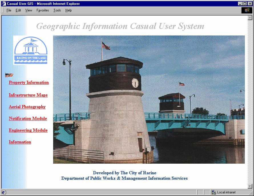
Figure 2. Casual User Interface - Home Page
Property Information
Selecting the Property Information link, the user accesses parcel maps which are dynamically linked to the City Assessor's Computer-Assisted Mass Appraisal (CAMA) database. The Page View displays an inset overview map. The user can select or search for a parcel, and the screen displays the parcel attributes in a view frame. Navigation and Search tools for this page, including Search by Address, are located at the bottom of the screen.
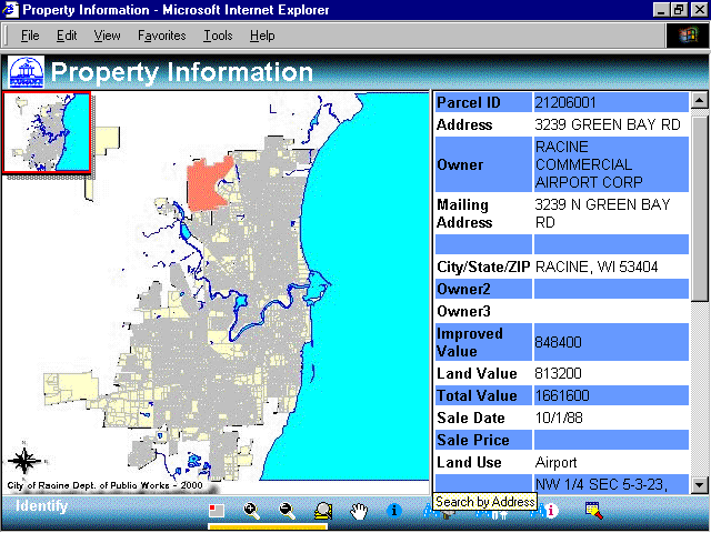
Figure 3. Casual User Interface - Property Information
Infrastructure Maps
Selecting the Infrastructure Maps link, the user accesses the City's Infrastructure GIS. This Page View displays an inset overview map. The user can select or search for a location, and the screen displays the feature attributes in a view frame. The user can activate various GIS layers for viewing maps of municipal features. The user can access additional levels according to the zoom view. Standard GIS tools are displayed at left of page.
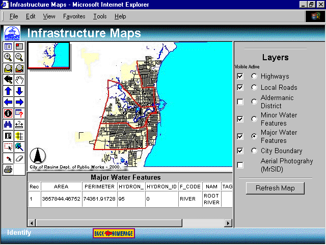
Figure 4. Casual User Interface - Infrastructure Maps
Figure 5 shows a zoomed-in view displaying additional layers of the Infrastructure Map Module after the storm sewer feature has been selected.
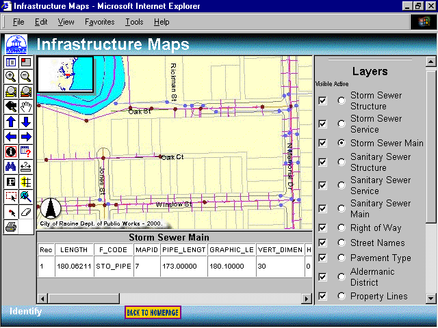
Figure 5. Casual User Interface -
Infrastructure Maps, Zoomed View of Selected Feature
Aerial Photography
Selecting the Aerial Photography link, the user accesses the City's digital ortho photographs. This Page View displays a high-resolution aerial view of the City of Racine. The user can zoom in on a particular location, and the screen displays only the pixels relative to the current scale factor. The scale factor is a feature of MrSID technology. Aerial Photography is accessible through the other modules, but is featured as a stand-alone viewer for user convenience.
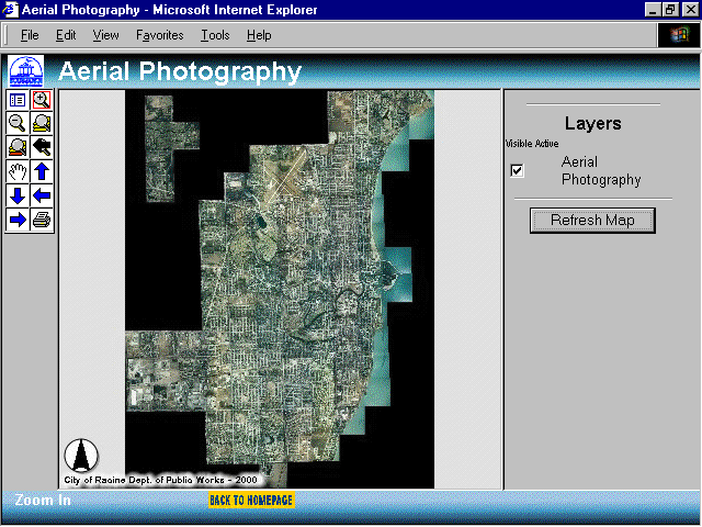
Figure 6. Casual User Interface - Aerial Photography
Notification Module
The Notification Module link accesses the City's parcel maps. The Page View displays a buffer zone surrounding a particular address for notification of population groups for emergency evacuation, disaster response, or other municipal planning needs. The user can zoom in on a particular location. View and Search tools are located at the bottom of the screen, and an input view frame for defining searches is at the right of the screen.
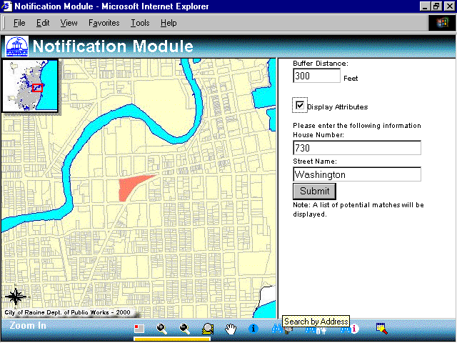
Figure 7. Casual User Interface - Notification Module
Engineering Module
Selecting the Engineering Module link, the user accesses the City's engineering maps. This Page View displays an inset overview map. The user can select or search for a location, and the screen displays the feature attributes in a view frame. The user can activate various GIS layers for viewing maps of municipal features. The user can access additional levels according to the zoom view. Standard GIS tools are displayed at left of page.
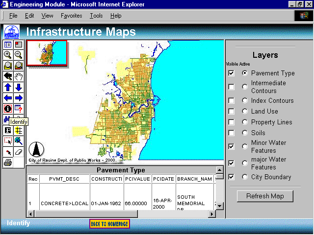
Figure 8. Casual User Interface - Engineering Module
Information
The Information link accesses the Page View that allows for user feedback. The Page View displays input fields for submitting user comments on system functionality and data issues concerning the other system modules. The user enters identification data and commentary for collection and review by the Web Administer. The purpose of the feedback is to identify data problems, gather constructive input about the GIS, and identify user needs for future planning.
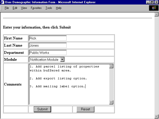
Figure 9. Casual User Interface - Information
Challenges
External Data Sources
The most significant challenge in implementing the Casual User Interface involved dynamic linking to external data sources. There were two main stumbling blocks. The first was connecting the parcel map with the parcel attributes in the assessors' CAMA database. The parcel maps from the County contain leading zeros in the parcel ID field, and are alphanumeric data types. The CAMA database also contains alphanumeric data types with leading zeros. The problem was that the out-of-the-box ArcIMS templates used numeric data types. Earth Tech resolved the problem by writing Java Script to create the dynamic links using alphanumeric data types. The following code was used to solve the problem:
| SQLquery = "SELECT " & dbResultFieldList & " FROM " & dbTable & " WHERE " & dbIDField & " LIKE '" & theNum & "'" |
The second challenge with the external data sources concerned using MS Access as the interface between ArcIMS map services and SQL Server. Record retrieval through ArcIMS slowed significantly when additional users accessed the system. After upgrading ODBC drivers, MS Access Service Packs, and some serious brainstorming, we concluded that ArcIMS map services should communicate directly with the SQL Server database through an ODBC connection. We added the following lines of code to the dbparam.asp file to connect to the CAMA ODBC data source:
| dbSource = "ArcIMS" ' ODBC System DSN |
| dbTable = "dbo.qryCasualUserGIS" ' Table(s) used |
Additionally, the Access database bottlenecked with the
volume of CAMA data funneling through the GIS query. The solution was simply to
create a new database in SQL Server and rebuild the query to limit the amount of data
flow. The new configuration allowed for quicker retrieval time, increasing
performance from 45 seconds to less than 3 seconds. The following is the SQL statement
currently used to provide the assessors' information from the assessors' CAMA database to
the Casual User Interface.
Click on thumbnail below (Figure 10) to view full page.
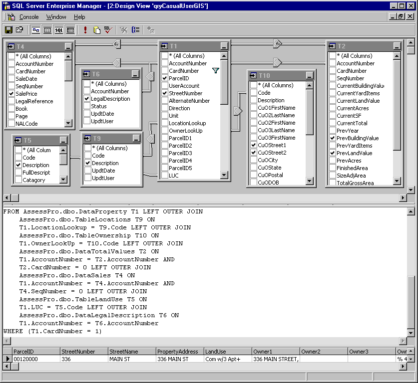
Figure 10. CAMA SQL Server Query
Digital Ortho Photographs
The challenge with the digital ortho photos lay in masterminding simple and seamless views of 104 tif photos totaling 10 Gb, a monstrous amount of data to manage in an Intranet GIS. The solution was using Lizard Tech's MrSID technology. MrSID compression technology streams only the necessary resolution for the current map scale factor. This allowed for creating a single, seamless, compressed digital image of 395 Mb, a drastic reduction in data volume, which provided greater manageability without loss of quality. This was a great success.
Resources
Esri's ArcIMS on-line site was Earth Tech's number one resource for resolving system development challenges. It served as a tremendous source of ideas, code examples, and user forums. This knowledge base was an extremely useful tool for addressing project challenges. The importance of this resource in Earth Tech's process of moving toward effective solutions cannot be overstated. Therefore, an acknowledgement is fitting and proper.
Benefits
The City of Racine has indeed benefited by implementing a Casual User Interface. The Police, Building, Health, Public Works, and Assessor departments are now using the browser-based GIS, with little or no training. The system provides user-friendly access and streamlined work processes. Benefits include quick access to GIS data by many, who no longer need to rely on technically-skilled GIS personnel to access the GIS data. The system provides easy data queries. Data sharing among departments eliminates the endless, untidy, and tedious paper shuffle. Quick and easy access to information takes the burden off staff, freeing personnel for other departmental tasks. The new system alleviated the blood, sweat, and tears associated with tracking down elusive data.
Performance
With the Casual User Interface Intranet GIS in place for over 6 months, performance issues have not been a problem (except for the previously discussed issue in this paper's "Challenges" section). This solution is notable because it required thinking "outside the box" because the remedy was not found going by the book--the ArcIMS manual.
A new problem emerged, and with it a process to isolate the bug. The problem was a time lapse for the initial map display. The challenge was to determine the cause of delay for a function that initially took a few seconds. The investigation involved several questions. Was it data? Was it hardware? Was it Microsoft IIS? Was it ASP code? Was it additional usage? We suspected that additional usage placed excessive demand on the server running both IIS and ArcIMS software. Research and testing were underway to solve the problem. Racine staff isolated a faulty fiber-optic network card. The problem has been resolved and work continues with ongoing maintenance and improvements.
The City of Racine's Casual User Interface is configured using a Compaq 3000 Alliance server with (2) Zeon 450 Mhz processors and 768 Mb RAM. Current software includes Windows NT (SP 5), ServletExec 3.0, Microsoft IIS and ArcIMS 3.0. Earth Tech is currently testing upgrades to ArcIMS and ServletExec technologies for possible performance enhancements.
Future
In the future,
the City of Racine will move toward an enterprise GIS. In the next year, Mr. Jones
anticipates integrating water distribution data and associated water utility data, as well
as Building Department permitting system data. Work next year will include
converting additional datasets--parks, traffic signals, and street lights. The City
of Racine is also investing in wireless technology. Mr. Jones anticipates wireless
devices for field inspections and data collection, integrated with the GIS to further
advance the City's technological capabilities. With more departments using the GIS,
the time has also come to begin enterprise data modeling and implementing ArcSDE
geodatabase technology to support the growing demands of the City of Racine.
Conclusion
The City of Racine and Earth Tech have worked together
for many years, creating and maintaining infrastructure data. As a team, the City
and Earth Tech built the Casual User Interface using Esri’s ArcIMS and ASP
technologies. The application was built to mimic MO IMS ISA’s which performed similar
functions. Despite challenges during development of the product, the Interface
has been successfully implemented, and achieved the goal of simple, seamless, centralized
browser access. Data quality and management are being secured and managed with
greater efficiency. The system is helping staff manage infrastructure assets of
the City, and Mr. Jones can now relax in the cool Lake Michigan breeze.
Acknowledgements
The author of this paper would like to thank all of those that helped make this paper possible, especially Jane Sommers who served as technical editor. Special thanks goes to the members of the City of Racine (including Paul Burdick, Jim Blazek, and Rick Jones), as well as the staff at Earth Tech (including Paul Cegelski, Leon De Souza, and Lorrie Ransome).
Author Information
Paul Sommers
Systems Analyst
Earth Tech, Inc.
4135 Technology Parkway
Sheboygan, WI 53083
USA
Phone: 920-451-2756
Fax: 920-458-8711
Email: paul_sommers@earthtech.com