Bai Tian, P.G.; Peter L. Nimmer, P.G.; and Alexander C. Easterday, P.G.
EA Engineering, Science, and TechnologyABSTRACT
A chlorinated volatile organic compound (VOC) plume in ground water has been studied as part of environmental investigations at a Superfund site, and an extensive volume of data was collected related to site geology and chemical conditions. Site decision-makers need understandable, 3D, graphic-based visualizations to assist with planning further investigations and optimizing remediation.
ARC/INFO, ArcView, Ground-Water Modeling System (GMS), and RockWorks were used to generate the necessary visualizations. These include geologic cross-sections and 3D stratigraphy models to visualize the geologic conditions of the site. Site topography, surface water flow networks, and drainage basin delineation were also created from the U.S. Geological Survey (USGS) Digital Elevation Model (DEM) data. Based on the ground-water analytical data of the past 17 sampling events (over 6 years), an animation of plume movements was generated. These 3D graphics and animation models enhance the understanding of the complex geologic and environmental data sets, thereby maximizing the usefulness of existing data and reducing the cost of the Long-Term Monitoring Program by minimizing the need for collecting additional data. In addition, complex data sets can be understood by non-technical stakeholders, and data visualizations have been used to summarize site conditions at public meetings.
INTRODUCTION
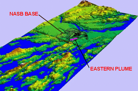
Since 1995, a long-term ground-water sampling and monitoring program has been conducted at Naval Air Station, Brunswick, Maine (Figure 1) by the U.S. Navy, with assistance from EA Engineering, Science, and Technology. The primary goal of this long-term monitoring is to track changing conditions within a ground-water aquifer impacted by dissolved-phase VOCs. The Navy has an operating pump-and-treat system in place to remove ground-water contaminants, and maintain hydraulic control of the VOC plume. To date, 17 ground-water sampling events have been conducted at over 40 monitoring points, and a site database of over 250,000 records has been generated.
Identification and tracking of temporal changes in contaminant concentrations are critical for assessment of ground-water plume movement, migration pathways, and to refining ground-water extraction systems to capture and remove contaminants. To assist in this effort, 3D models and animation were generated to illustrate the complex site geologic conditions, spatial relationships of the plume and relevant geologic units, and extent of the plume and its changes with time.
Figure 1Ś3D topography of the Naval Air Station and adjacent area, Brunswick, Maine, created from USGS DEM data with ArcView 3D Analyst. The pink area is the approximate extent of the Eastern Plume, the focus of this paper. North is toward the upper right. This graphic is useful in illustrating the spatial relationships between the site and nearby surface waterbodies.
SITE GEOLOGIC AND HYDROLOGICAL CONDITIONS
In order to design effective remedial measures, decision-makers required new tools to understand the geologic and hydrologic conditions of the impacted area. Major concerns include overburden geologic units, contaminant distribution with the geologic units, surface and ground-water flow patterns, and the interaction of ground water and surface water.
Based on the geologic data from over 200 boring logs, a 3D visualization of the Eastern Plume stratigraphy was generated (Figure 2). This visualization has been useful in illustrating the geometry of the four geologic units in the Eastern Plume area (the Upper Sand, Transition, Lower Sand, and Clay). The Lower Sand aquifer contains the majority of VOC-impacted ground water at this site. Total VOC concentrations up to 15,000 parts per billion have been detected. The Lower Sand unit has been the focus of remedial efforts at the site and, therefore, the thickness and geometric variations in 3-dimensional space of this unit are of particular interest.
In order to better visualize the Lower Sand layer, this unit was extracted from the 3D stratigraphy model (Figure 3). It can then be rotated and studied from any angle and distance. Figure 4 shows the north to south geologic cross-section of the Eastern Plume area. These visualizations show that the Lower Sand layer thins toward the northern and southern sides of the Eastern Plume. It is confined between two lower permeable units (the overlying Transition unit and the underlying Clay unit). This geologic relationship indicates limited migration of the plume outside the area, which contains the Lower Sand layer.
The 3D geometry of the Lower Sand layer has also been useful in understanding the spatial distribution of this ground-water plume. It appears that the highest concentrations of total VOCs are found where the underlying Clay unit forms a natural depression, thereby limiting contaminant migration toward other areas.
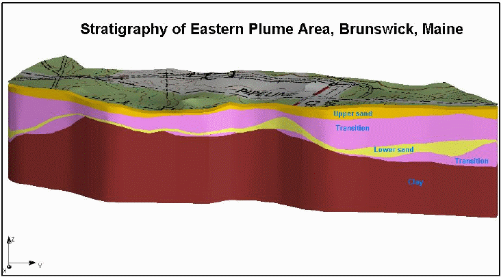
Figure 2Ś3D stratigraphy of the Eastern Plume area, created with GMS with the boring data exported from the EquIS Geology database. USGS 7.5-minute topographic quadrangle was draped on the top of the terrain to enhance visualization. North is on the right side and south is on the left side.
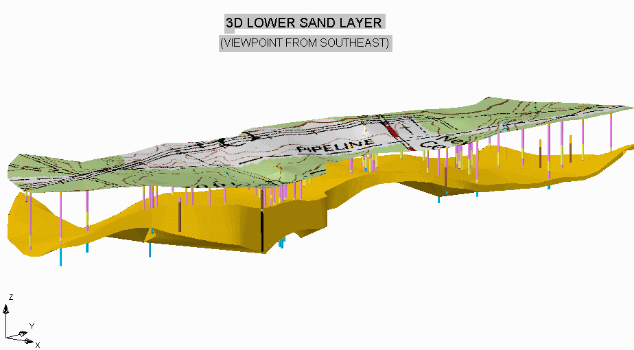
Figure 3Ś3D solid model of the Lower Sand geologic layer showing the boring logs used to generate this graphic. DRG was draped on the terrain surface to enhance the visualization of the unit. On this model, north is on the right side, while south is on the left side.
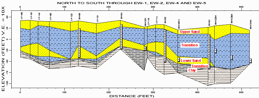
Figure 4ŚNorth to south geologic cross-section of the Eastern Plume area, created with RockWorks, based on geologic data exported from EquIS Geology database. This graphic also illustrates monitoring well screen intervals and their relationship to site geologic units. This graphic has been used to understand the relationship between VOC concentrations and site geology. The Clay unit is composed of confirmed (gray) and inferred (white) layers.
The deepest geologic layer is a low permeable Clay unit, which serves as a natural barrier to prevent the vertical migration of the contaminated plume. In addition, the lateral changes in clay thickness may also limit horizontal ground-water flow. Therefore, the 3D topography of the clay surface is very important to effectively understand plume dynamics. Figure 5 shows the top surface of the confining Clay unit and the outline of the contaminant plume. This 3D graphic illustrates the spatial relationship between the plume and the top of the Clay unit. The highest VOC concentrations (the thick yellow line shapes) are in the depressions of the clay surface. This graphic has been used by decision-makers to visualize the relationship between the VOC plume and site geology.
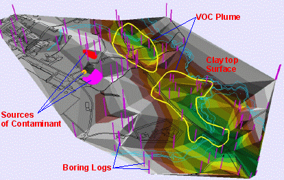
Figure 5¢3D view of the top surface of the clay unit (a natural confining layer located approximately 80 ft below ground surface) and the distributions of the VOC ground-water plume. White or grey indicates higher elevation, green lower elevation, and brown medium elevation.
Figure 6 displays the 3D shallow ground-water table and its flow directions of the Eastern Plume and adjacent areas. Compared with a 2D ground-water elevation contour map, this 3D representation is much easier to visualize the relationship between the ground-water flow patterns. This also corresponds well with the topography of the top surface of the Clay unit (Figure 5), suggesting that site ground-water flow is likely affected by site geology.
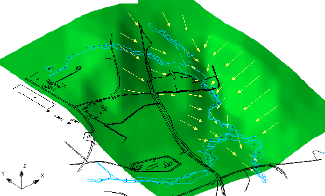
Figure 6Ś3D shallow ground-water table and flow directions, Eastern Plume and adjacent areas. This visualization has been used to simply illustrate complex ground-water flow patterns for site decision-makers, and non-technical members of the public.
For this site, surface water conditions are also important. Surface water flow patterns and drainage divides are influenced by topography of the area. Based on the USGS DEM data, a visualization was generated to illustrate the surface water flow system away from the site. Drainage basins were delineated for the site and the surrounding areas (Figure 7). This figure illustrates that the surface water on the site flows toward two drainage basins and is useful in understanding the surface water flow patterns outside the base boundary. Based on this regional flow field, the surface water flow network within the site was simulated using particle tracking. Imaginary surface water particles were released from within the Eastern Plume area to visualize the flow paths both inside and outside the base (Figure 8).
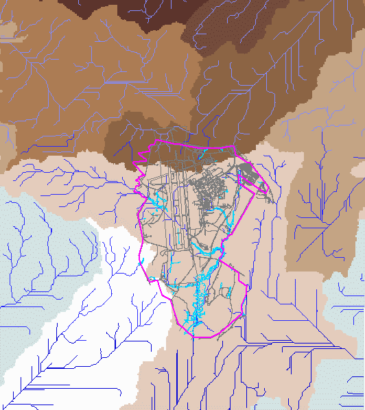
Figure 7ŚSurface water flow network and drainage basins of the Naval Air Station and its adjacent areas, generated from USGS DEM data with Arc/Info hydro analysis utilities. This graphic was used to visualize surface water flow patterns for off-base areas.
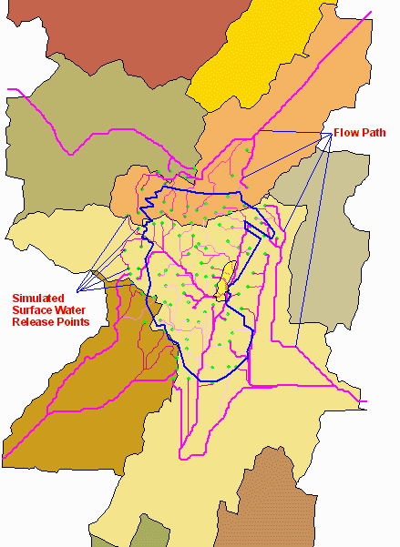
Figure 8ŚThis graphic shows surface water flow network within the site and particle-tracking flow paths from the site toward off-base areas. The green dots are simulated surface water release points, while the pink lines are flow paths. This graphic was used to understand surface water flow paths from the base toward surrounding areas.
3D DELINEATION OF THE PLUME AND ITS CHANGES WITH TIME
At this site, 17 sampling events have been conducted in the Eastern Plume area since 1995. Large amounts of analytical data (over 250,000 records) have been accumulated during this Long-Term Monitoring Program. By analyzing these data, site decision-makers have been able to assess the plume behavior and determine future sampling and remedial options. Correctly understanding and interpreting the data are crucial to making informed decisions. However, decision-makers have been challenged by analyzing and interpreting such a large and complex data set.
To assist with the interpretation of the complex site analytical data, an animation film was created to illustrate the changes of VOC concentrations over the 17 sampling events from 1995 to 2000 (Figures 9 and 10).
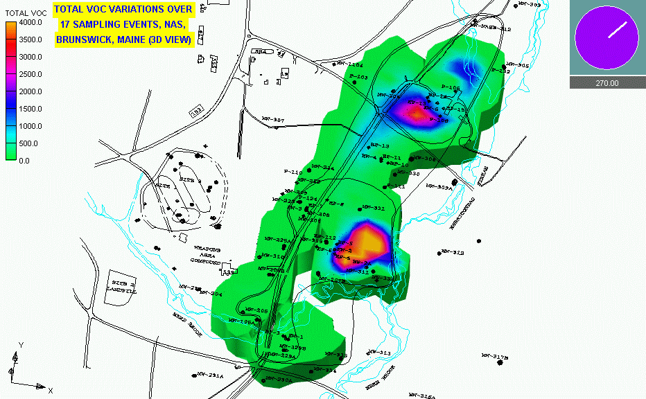
Figure 9Ś3D representation of Eastern Plume and its changes over 17 sampling events (1995 through 2000). This picture is a snapshot of the animation film showing the plume at around event 3.
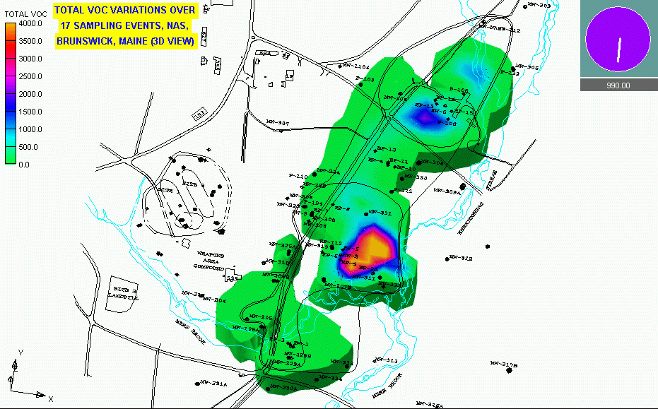
Figure 10Ś3D representation of Eastern Plume and its changes over 17 sampling events (1995 through 2000). This picture is a snapshot of the animation film showing the plume at around event 9.
This animation was used to visualize site analytical results and understand plume behavior. The graphic suggests that the plume is confined in the depressions of the top surface of the Clay unit (Figure 5), and may be naturally confined by site geologic conditions. Although the extent and concentration of the plume change over the 17 sampling events, the plume did not migrate significantly, and the areas of highest VOC concentrations were contained within the northern and southern lobes. This preliminary conclusion is supported by 2-D and 3-D geologic visualizations discussed earlier.
SUMMARY
For large and complex environmental sites, 2-D and 3-D visualization techniques can enhance understanding and interpretation of geological, hydrological, and analytical data. Cost savings can be achieved by using existing data to visualize site conditions, thereby maximizing the use of existing data while minimizing the need to collect additional data. The generation of visualizations for site geologic conditions and temporal and spatial changes in plume behavior have been useful in discovering relationships between data sets and optimizing sampling and remedial decisions.
ACKNOWLEDGMENTS