Paper # 397
Minnesota Department of Natural Resources
LandView -- Map Objects Application
Development -- July, 2001
|
Paper # 397 Minnesota Department of Natural Resources
|

LandView allows the user to view one background map at a time. These data sets tend to be very large and are usually tiled.
Background maps to choose from include:
Digital Orthophoto Quadrangles
(DOQs)
A Digital Orthophoto is a digital image of an aerial photograph with displacements caused by camera angle and terrain removed (See above Graphic). A DOQ combines the image characteristics of a photograph with the geometric qualities of a map.A DOQ is a scanned 9 by 9 inch photo, taken from an airplane at approximately 20,000 feet. These photos are available from USGS as one meter compressed JPEG images for $32 per CD-ROM disc. The CD-ROMs contain one county per CD, but larger counties require multiple CDs.
Please refer to the following link for complete documentation:
http://mapping.usgs.gov/www/ti/DOQ/
Scanned USGS Quadrangle Maps
(DRGs)
A digital raster graphic is a scanned image of a U.S. Geological Survey (USGS) standard series topographical map, including all map collar information. The image inside the map neatline is georeferenced and fit to the projection of the source map.
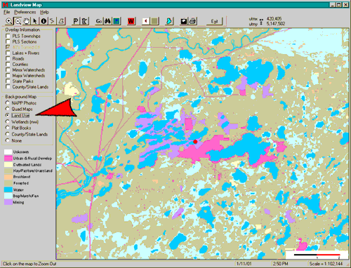
Land Use
In LandView these are 30 meter raster files classified into 8 categories by color. These include: Unknown, Urban & Rural Devolpment, Cultivated Lands, Hay/Pasture/Grassland, Brushland, Forested, Water, Bog/Marsh/Fen, and Mining.
National Wetlands Inventory (NWI)
The U.S. Fish and Wildlife Service produces information on the characteristics, extent, and status of the Nation's wetlands. This information is used by Federal, State, and local agencies, academic institutions, U.S. Congress, and the private sector. The NWI has mapped 89% of the lower 48 states, and 31% of Alaska. The Act requires the Service to produce a digital wetlands database for the United States.
Digital Plats
A computerized version of a plat map. These are from the Rockford Plat Books that have been rectified by DNR staff. They are hand drawn maps and cannot be distributed beyond the DNR.
DNR Land Ownership
DNR land ownership and administrative interest is mapped to the PLS forty level. This layer shows the DNR land records organized by administrative unit (forestry, wildlife, parks, etc.) The data are limited to a forty level resolution. Therefore, holdings that are less than a forty are represented as a full forty. This layer is available as both a Basemap and Reference Data