The Development of Urban Information Systems in Japanese City Planning
Takashi Kugo, Tetsuo Karube, Akira Koshizawa
ABSTRACT
After the Great Hanshin-Awaji Earthquake in 1995, the concept of GIS became popular and rapidly spread in Japan. The Kanagawa Municipal Government has started its own gUrban Information Systemh since 1985 and been playing a leading role of GIS implementation among other municipal governments in Japan.
We will introduce how GIS is getting popular in Japan by referring the gUrban Planning Information Systemh developed in Kanagawa Prefecture. In the text, we will also mention how they built the database, its maintenance, the importance of gBasic City Planning Surveyh and the policy of practical use of GIS for the Urban Planning.
1. Introduction
It was in the 1970s that Geographic Information System (GIS) was first introduced in Japan. This was not late compared to the introduction of GIS in the Western world. In the mid-1980s, some advanced Japanese local governments such as Kanagawa Prefecture and Tokyo Metropolis started production runs of governmental administrative systems based on GIS. However, at that stage, only a few forward-looking local governments introduced the systems for basic applications such as fixed asset management and city planning.
In recent years, the recognition of GIS power become widespread, accelerating rapid proliferation of the systems in the local governments. Applications have been widened also -- they now extend to national welfare and education.
This study focuses on the development of city planning GIS applications that was the pioneer GIS application in this country. As a practical example, the study will introduce gthe City Information System of Kanagawa Prefecture,h which is supported by a huge and elaborate GIS database.
2. Use of GIS in City Planning
2.1 City Planning in Japan
The City Planning Law of 1919 defined city planning in Japan. In 1968, the law underwent major revisions; this amended version is still in effect today. The City Planning Law was enacted with the aim of achieving orderly urban development; a city plan is put together as a kind of master plan, which paints a picture of how the city should look roughly 20 years hence. Policies are then created in order to achieve these broad goals. Thus, city plans comprise the following components: control of land use, which regulates and guides the use of land and structures; creation and improvement of city facilities, including roads and parks; and city land development projects, aimed at developing and improving city land.
Note that with some exceptions, city plans are formed by prefectural and municipal governments*. Among these planners, there is a commitment to making the city plan a master plan for the city.
Below, we will give a brief overview of two aspects of city planning intimately related to GIS: basic survey for city planning, and city planning maps.
*Japanfs administrative hierarchy consists of the national government at the highest level, followed by the prefectures (as well as certain cities designated by government ordinance; see below), and followed in turn by the municipalities (cities, towns and villages). Prefectures and municipalities play the leading role in city planning. Recent legal reforms have placed much of the authority for city planning in the hands of the municipalities, which are the governmental bodies in closest contact with the local community. Note: the government specially designates cities with a population of at least one million; these cities have the same hierarchical standing as the prefectures.
Basic Survey for City Planning
Article 6 stipulates that gbasic survey for city planningh shall be conducted in order to properly formulate and implement city plans. Basic city planning surveys are generally conducted every 5 years, and their results are used to revise the city plan, the span of which is about 20 years. These surveys focus on land use and structures, and also gather basic information about population, industry, city land, traffic volumes, and more. These wide-ranging aspects are common to all basic city-planning surveys implemented in Japan.
City planning surveys are implemented at the prefectural level. Each prefecture specifies its own gbasic survey for city planning guidelineh detailing the contents of the survey, reflecting the situation of the region.
City plans place limitations on property rights. For this reason, Article 14 stipulates that the districts used in city plans must be easily delineable. Thus, city plans display districts using administrative maps and engineering maps. Administrative maps are at a scale of approximately 1:10,000, and are used to maintain consistency and coordination at the city level. Meanwhile, engineering maps are at a scale of around 1:2,500. They show details of individual city plans, clearly showing the limitations and scope of each city plan.
2.2 Basic City Planning Maps
The amendments of 1968 first clearly stipulated the use of administrative maps and engineering maps for the management of city planning districts. In Japan, updating and creating the base maps used for creating these maps is a vital role of the city planning administration. For this reason, engineering maps are usually referred to as basic city planning maps. These maps clearly delineate and manage city-planning districts, and for this reason, changes in the topography demand that they be replaced with new maps.
Basic city planning maps must be created in accordance with the procedures stipulated by the Geographical Survey Institute. In the past, these maps were created in analog format. In 1988, however, the Geographical Survey Institute proposed a standard for digital mapping, and thus in recent years, more maps are being created in digital format. This has allowed digital topography information to be used. Currently, about 60% of local governments nationwide create maps in digital format.
2.3 The Development of GIS in the City Planning Field
GIS was first used in the city planning field during a period from 1975 to 1976, when the Ministry of Construction developed the Urban Information System (UIS). The main purpose of this system was to develop technologies for city measurement. The system did not catch on, however, due to the limitations on computer technology of the time. Then in the 1980s, activities to popularize and promote awareness of information systems began on a trial basis.
This is when Kanagawa Prefecture developed its Urban Information System. This system was created to be a system that could provide data for making city policy decisions in the prefecture, and features (1) a link between basic city planning surveys and GIS,(2) thereby creating a system for updating data and ensuring its effective use;(3) ease of use by government employees without extensive training; and (4) the realization of simple, easy-to-understand analysis means through ranking maps and other tools.
The concept for developing this system was put forward by Professor Koshizawa, who is also one of the authors of this paper. This is a first-of-its-kind system undertaken by Pasco.
This development concept met the needs of government administrators, and Pasco subsequently developed urban information systems for the prefectures of Tokyo, Chiba, Saitama, and elsewhere.
In parallel with these prefectural-level urban information systems, Pasco also developed urban information systems for such government ordinance-designated cities** as Yokohama, Kawasaki, and Hiroshima. Providing information to city residents on such matters as area of application and city planning roads when applying for new construction and development is one of the main jobs of government ordinance-designated cities. For this reason, the main goal of the urban information system at the government ordinance-designated city-level is the management and disclosure of city planning information.
For both the prefectures and the government ordinance-designated cities, urban information systems are put together using basic city planning maps as base maps, and adding basic survey for city planning and city planning maps as subject-specific maps.
** A ggovernment ordinance-designated cityh is a city with a population of at least one million; these cities have the same status as the prefecture with regard to city planning.
3. Kanagawa Prefecturefs Urban Information System
Kanagawa Prefecture is located in the southwest of the Japanese capital, nearly in the center of Japan. It has an area of about 2,400 m2, and the population of roughly 8.5 million. The prefecture comprises a total of 37 municipalities, including two government ordinance-designated cities: Yokohama and Kawasaki. The prefecture includes cities deeply linked with the United States, including Yokohama, the place where modern Japan was born and also such cities as Yokosuka and Zawa, home to US military bases. The prefecture also includes Kamakura, with its rich history as the seat of the Japanese Shogunate in the 12th to 14th centuries; Miura, known for its suburban agriculture; and Kawasaki, with its (heavy and chemical) industrial belt on the coast. Kanagawa prefecture continues to pursue city planning in keeping with these unique characteristics.
3.1 Urban Information System Overview
Kanagawa prefecturefs urban information system was developed in 1985 based on ArcInfo. After this, the system has undergone a major overhaul every 5 years. Currently, the system is in its third generation. (The fourth-generation system is scheduled to be completed this year).
The major overhauls of the urban information system are conducted in conjunction with the completion of the hardware lease period, and the implementation of the basic survey for city planning, which forms the core of the systemfs database. The greatest change at the system level is the change in platforms with each overhaul. Each successive generation has used progressively better hardware. The first employed a super mini computer platform; the second a mainframe; and the third workstations (the fourth-generation system is scheduled to employ PCs).
In addition, as computer performance has increased so has the amount of data they could handle. Thus, the size of the database has grown with each generation. The first-generation system based its data on statistical regions called sub-zones (an area comprising several city blocks, with an average area of roughly 1.2 ha and an average population of roughly 500). The second and third generations, however, used more fine-grained data, including land use and structures. Over this period the basic scale of GIS data has also contracted, from 1:10,000 to 1:2,500.
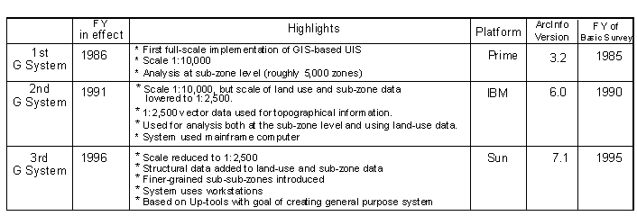 Table3 -1 Development History
(2) Bigger Databases and the Basic Survey for City Planning
Kanagawa prefecturefs urban information system was developed in order to provide data for city planning policy decisions. The systemfs database is based on information collected and stored from the basic survey for city planning.
When proposing city plans, comparing and studying data from statistical district units forms an effective index. Thus, the system has stored a variety of data at the sub-zone level, which is the statistical district unit used by the system.
As of the present time, data from 3 surveys has been stored: 1985, 1990, and 1995. While the second-generation system kept about 200 items of data at the statistical district level, the third-generation system increased this number to about 600 (increasing such factors as amount and rate of change to the database dramatically increases its size).
In addition to information at the statistical district level, actual on-the-ground data is also invaluable. For this reason, data vital for city planning, including land use and structures, was stored at a scale of 1:2,500.
Moreover, the data indicating city-planning districts used in planning decisions is stored at a scale of 1:2,500, in order to ensure a system level in accordance with the requirements of the City Planning Law.
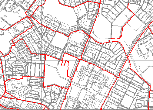 Figure 3-1 Sub-zone
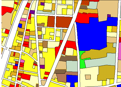 Figure 3-2 Land Use Situation
 Table 3-2 Kanagawa Prefecture:Urban Infomation System Database Overview
The details of the basic survey for city planning are left up to the prefectural government. Kanagawa prefecture has created a gbasic survey for city planning guideline,h which assumes that its data will be used by the urban information system. One particular innovation of this system is the use of statistical units called sub-zones; this eliminates the privacy concerns, which had made the use of census data and personal asset data unfeasible in the past. This has made the urban information system database extremely rich, and it is finding new applications at a breakneck pace.
Two unique surveys included in the basic survey for city planning are the land use and structure surveys, which provide the most important data for proposing city plans. The basic survey for city planning uses the information from these surveys to create two maps: a land-use situation map, and a structure application map. GIS is an extremely powerful tool for creating these maps. Before the adoption of GIS, each building on the map had to be colored in by hand. Since the adoption of GIS, however, the coloring is performed by the computer, greatly reducing time and expense. And GIS does not only store map colors; it also stores land-use and structural data as GIS information, making it possible to quickly provide effective references for city planning. The next basic survey for city planning is scheduled to be held in 2002; when this is implemented, the total of 20 yearsf worth of data from 4 different surveys would be collected and stored. This rich database is an invaluable asset not often seen in Japanese GIS systems, and it will provide a comprehensive system environment, enabling city plans to be based on objective indices.
3.2 Applications for City Planning
Kanagawafs urban information system was designed to help cities in the prefecture formulate policies. Thus, it is being applied to actual city planning in more and more cases. In this section, we will outline uses of the system for city planning, illustrating with actual examples.
(1) Application for Revising Boundaries
Japan has a redistricting system as a policy tool for control of land use. This is part of a policy aimed at preventing disorderly urban development, by designating certain areas as gurbanization promotion areasgurbanization promotion areash - districts which should be urbanized - and gurbanization control areash - districts in which urbanization should be curbed. This system was one of the main revisions to the City Planning Law in 1968, and is a policy for controlling urban growth. It is vital to ensure that urban sprawl is not taking place in gurbanization promotion areas,h in order to develop the city in a planned fashion. As the city matures, the amount of its area designated as a gurbanization promotion areah expands. At this time, it is vital to ascertain how much land remains unused in the gurbanization promotion areas.h
The urban information system is an extremely powerful tool for this task, showing the state of city land both visually and quantitatively.
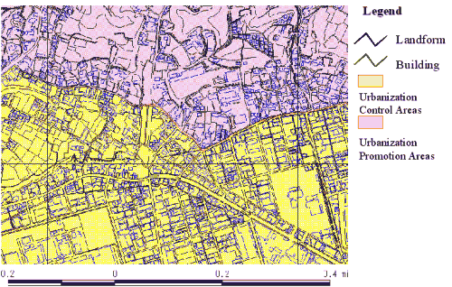 Figure 3-3 Building Development Situation
(2) Grasping the Condition of City Facilities
The creation and improvement of city facilities requires that the most effective use be made of limited resources. This is an especially vital element when planning the city parks that provide oases in the city environment. City districts developed in a planned fashion secure a certain amount of land for parks, but older sections of the city may not always have sufficient park land.
The urban information system makes it possible to calculate the effective area covered by park candidates using a buffer function. For this reason, crossing city density and other indices makes it possible to provide references for determining city park quality.
The use of urban information system makes it possible to offer easy-to-understand, convincing references.
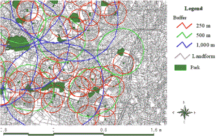 Figure 3-4 Effective Park Area
(3) Development and Improvement of City Land and City Stability
In Japan, most homes are wood-framed. In addition, city density is quite high with a large number of narrow roads less than 4 meters in width. This makes fires an enormous threat to the cities in Japan. In addition to fire prevention, the establishment of fire rescue and recovery centers is a vital city fire-fighting task.
City development must proceed after assessing city safety from a number of angles, including the threat of building collapse, the threat of fire, and the danger imposed by evacuation activities. The urban information system is a powerful tool for this type of assessment of a cityfs current threat level.
4. GIS Trends in Japan and Future Issues
4.1 GIS Trends in Japan (at the governmental level)
While GIS was adopted in Japan in the early 1970fs, its development has subsequently lagged behind that in Europe and the United States. Some of the main reasons for this were the lack of an organized research institution, and the disappointing results from attempts to gather spatial data. This has greatly hindered the standardization of GIS as well as its subsequent development.
Subsequently, the Great Hanshin-Awaji Earthquake (also known in the West as the Kobe Earthquake) taught us the need for a central geographical information base at the national level. For the first time, the government created a plan to encourage the adoption of GIS, and a commitment was formed at the government level to digitize map data. This was the first full-scale effort in Japan to adopt GIS.
This plan identified 1996 - 1998 as an ginfrastructure-building periodh; 1999 - 2000 as a gdissemination periodh; and 2002 as a greview period.h This is the last year of the gdissemination period,h aimed at building on and updating the national spatial database, promoting the nationwide adoption of GIS, completing the national spatial database, and popularizing GIS technologies.
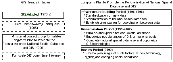 Figure 4-1 GIS Trends in Japan at the governmental level
The Ministry of Construction, which serves as the central supervisor and coordinator of governmental city planning activities, is working toward the standardization of GIS data; in 1999, it published guidelines for the creation of GIS data for city planning. This guideline defines the quality of GIS data, as well as catalogs and meta-data for city planning. This includes not only trends in Japan, but also is based on the international ISO/TC211 standardization movement.
 Figure 4-2 GIS Trends in Japan at the Municipalityl level
With the reorganization of Japanese governmental agencies this year, the high-level functions formerly performed at the national level have been entrusted to municipal and other local governments. This makes it even more important for municipalities to administer the system properly. There is also an increasing demand from the community for government disclosure, requiring the communication of the proper information in an easy-to-understand format.
Thus, changes in national commitments, the reorganization of the national government, and changing demands from Japanese communities will rapidly shift the work of GIS from its previous domain of adoption and use in a limited number of prefectures and cities designated by government ordinance, to all municipalities in Japan.
4.2 Future Issues (Commitment by Pasco)
The national government is promoting the digitization of map data. Most municipal government resources are limited, however, and in order to popularize GIS among them, it will be necessary to show them its power and the cost-effectiveness of a GIS. Moreover, while the national government subsidizes the construction and improvement of roads and parks, no national subsidy program exists for the creation of information systems along the lines of GIS. Thus, it may be necessary to create a subsidy program for the building of information systems in order to encourage the further popularization of GIS.
It may also be necessary to move beyond the traditional gmap managementh applications of GIS - computerizing and digitizing city planning, and simulating changes in the city resulting from different plans - and look into GIS applications from totally new viewpoints.
As of the present time, by far the greatest number of governmental GIS use such Esri products as ArcInfo; Kanagawa prefecture is a representative example of this. As GIS becomes more popular in Japan, Pasco, the authorized distributor of Esri products in Japan, must further solidify the position of Esri products as a GIS engine. It is a vital task for Pasco to demonstrate the superiority of Esri products for GIS and increase awareness of Esri products as the GIS standard.
ACKNOWLEDGMENTS
I hereby thank prof.dr. Akira Koshizawa and Mr. Tetsuo Karube for their helpful advice and encouragement to present myself at Esri User Conference.
REFERENCES
Urban Atlas, City and Geographic Information System, Standardization guidelines of City
Planning GIS
AUTHOR INFORMATION
Takashi Kugo
Office of Urban GIS Development
Pasco Corporation
1-1-2 Higashiyama
Meguro-ku, Tokyo 153-0043
Japan
Telephone: +81-3-6412-2505
Fax: +81-3-6412-2592
E-mail: Takashi_Kugo@pasco.co.jp
Tetsuo Karube
Section Manager
Office of GIS Technology Development
Pasco Corporation
E-mail: Tetsuo_Karube@pasco.co.jp
Akira Koshizawa
Professor of Hokkaido University,Graduate School of Engineering /
Member of the Council for Social Infrastructure, Ministry of Land,Infrastructure and Transport
Office of Hokkaido University
E-mail: ak@eng.hokudai.ac.jp


