By Gerbesioti Apostolia, Dr. Michael Paraskevas
ABSTRACT:Using GIS technology as an agent for innovative changes in educational activities of Greece, we have developed a system, which aims to reform the way of managing and monitoring the functionality conditions of Greek school units. The project is focused on the implementation of a Greek school network infrastructure, which will act as an information source and communication tool.
This paper presents the geographic capabilities of the system, describes our approach to design and outlines plans for further development.
1. INTRODUCTION
The project "Winds of Aiolos" is the next step of successful pilot implementations in the field of development of networking technologies in the learning process. It is applied in a significant number of schools and it has created an extensive networking infrastructure all over Greece.
On the basis of the influence of networking technologies on the educational activities and according to the international experience, the usage of the network on the educational procedure acts as:
a) Information resource of certified pedagogical data
b) Learning tool
c) Communication tool
d) Knowledge objective
2. NETWORK ARCHITECTURE
The design model and the functional specifications of the Greek School Network are based on the networking technology and methodology, which has been evolved within the framework of the worldwide evolution of the Internet. That model is based on the networking protocol suite known as TCP/IP.
The design of the network expects the implementation of a hierarchical structure that consists of:
Backbone Network. The Greek School Network (Fig. 1) does not develop its own backbone network but it uses the existing Greek Research & Technology Network (GRNET). GRNET is a valuable national resource and it is used for the same goal from the Greek Universities Network. It composes the most developed network in Greece as it consists of national and international connections of high capacity, high know-how, effective management, pioneer services and co-operation with corresponding research networks in Europe and globally. The Greek School Network is connected to GRNET at seven main points (Athens, Thessaloniki, Patra, Iraklio, Larisa, Ioannina, and Xanthi).
Distribution Network. It is realized by the projects "Winds of Aiolos" and the "Greek Network for Education - EDUnet" and it ensures the integrated connection of schools and administrative offices with the backbone network. It is distinguished in two levels:
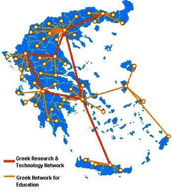
Figure 1. Distribution Network for the Greek School Network
First layer, which consists of 9 wide geographical areas, which represent the main nodes of the distribution network.
Second layer, which consists of 51 smaller geographical areas (which correspond to the prefectures of the country) and represent the secondary nodes of the distribution network. Networking and computational equipment is installed in the capital of each prefecture so as to technically and economically improve the access of the schools of the prefecture to the network and to the supply of networking services.
Access Network. It is realized by the projects Winds of Aiolos and EDUnet and it interconnects directly the schools and the administrative units of a prefecture to the familiar prefectural node with the appropriate telecommunication connections (Figure 2)
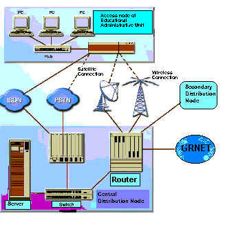
Figure 2. Telecommunication connections
3. GIS APPLICATION
A GIS application has been developed to serve as the tool for geographical visualization of the functionality condition of the Greek school network. This application also exploits existing information coming up from school units through the use of the Geographical information system.
The application uses digital maps in order to print the exact position of Greek schools. An Oracle database serves as the integrated repository for all data needed for the system. The database consists of school attributes data such as address, city, telephone, email, student and educational resources, building infrastructure, computational and network equipment, all connected with each node on map.
Finally, using ArcIms the application gives the capability of publishing digital maps on the Web (Intranet, Internet)
3.1 Design methodology
The overall goal was to design and develop a user-friendly, prototype, web-based GIS viewer. For this reason ArcView and ArcIms have been used for the implementation of the application.
For the implementation two main works have been taken place:
a) The incorporation of all data needed in the information system
b) The application development, using Avenue programming language.
Digital maps of 28 Greek big cities in the level of building plus 2 metropolitan areas (Athens, Thessaloniki), maps of Greek perfectures and road network have been used in the project
The main application objective was to expand the existing capabilities of Arcview using the Avenue programming language in order to provide :
a) Searching schools based on their name, code, perfecture, etc.
b) Calculation of statistics per city, perecture, municipality
c) Identification of school characteristics
d) Map printing
e) Classification of schools by the educational grade (elementary school, high school, etc).
f) Modification of pre-existing data
g) Composition of queries
h) Easy access to the Oracle database for the management of textual data.
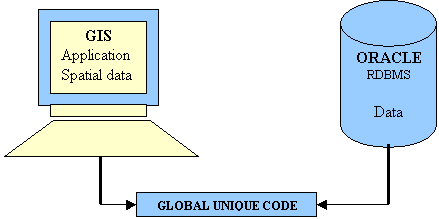
Figure 3. Connection of GIS application with the ORACLE relational database management system
3.2 Current status and further developments
In order users to extract school units information, they have first to select from the total amount of data a subset, defining either a geographical area (city, prefecture) or choosing a certain school defining its name.
The red spots on map represent the 30 cities in the level of building block, which have been used in the project. (Figure 4)
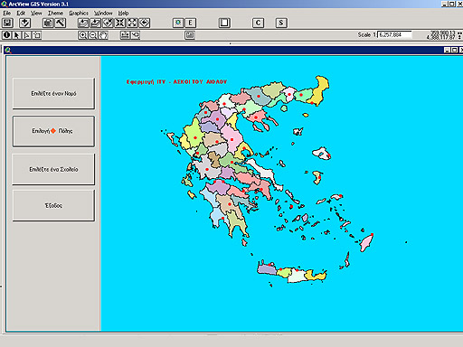
Figure 4
By choosing the second button, "ĹđéëďăŢ đüëçň" ("Choose city") and click on the red spot two windows appear. The right window shows the map of the city in the level of building block with the school units and with the left window the user controls the appearance of information on map. (Figure 5)
There are several options such as adding or removing a school unit, printing the map, changing the school unit symbol, finding a school unit on map by its name etc.
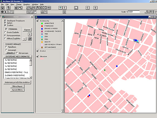
Figure 5
With the info tool the user is able to derive information for each school unit . By clicking on a school unit on map a form with all the database information appears. (Figure 6)
Through the query editor, users can easily perform queries and derive data from database. Query results can be viewed both textually in a tabular form and geographically on map indicating the exact location of school units with similar characteristics (Figure 7)
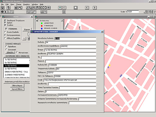
Figure 6
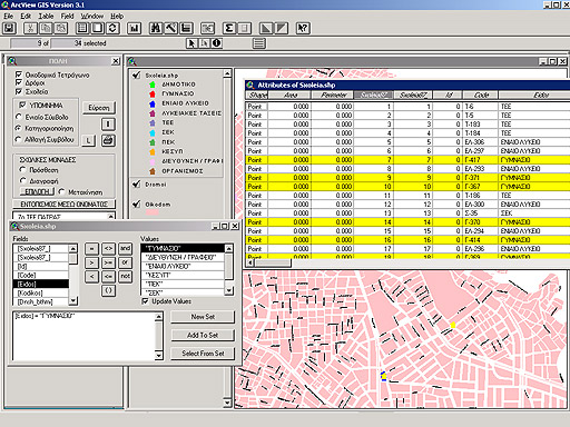
Figure 7
This work is the first step towards a long open road. The main work for future development is to add to the system the capability of the geographical visualization of the functionality condition of each school unit. Through the use of Open View, a comprehensive network management solution, the user will be able to discover the status of network devices and when a major device fails to pinpoint the failure. This system returns either 0 or 1 (not connected, connected). Importing the answer into the Oracle database and connecting it with each school unit the user will be able to visualize on map its functionality condition.
4. CONCLUSION
The need for adaptation of educational activities in the demand of new age and information society, according with the increment of needs of the administration structure, predicate the insertion of new technologies of computer science and network in all levels of the educational system. Through this project and its further developments, the implementation of an advanced unified Greek school network will be realized.
5. ACKNOWLEDGEMENTS
We thank Marathon Data Systems (MDS) and its developers and in person Mr. Adonis Kontos, president of MDS, for his significant participation for the completion of the project.
6.REFERENCES
Oxford University press, N.Y. Managing Geographic Information System Projects, WILLIAM E. HUXHOLD and ALLAN G. LEVINSOHN 1995
University Consortium for Geographic Information Science (UCGIS). 1996. Research Priorities for Geographic Information Science. Cartography and Geographic Information Systems, 23(3), pp. 115-127.
C. Harder.1998. Serving Maps on the Internet. Geographic Information Systems on the World Wide Web. Environmental Systems Research Inst., Inc.
AUTHORS