Presently, there are two types of survey data available in Germany: The Automated Real
Estate Map (ALK, scale 1:1000) and the Authoritative Topographic and Cartographic Information
System (ATKIS) with the Digital Landscape Model (DLM, scale 1:5000). This data is available
for most of the country and represents the basis for urban and landscape planning.
A Geographic Information System (GIS) is the main instrument used by municipalities to
combine the most important databases with subject specific data from various departments
involved.
The contribution presented describes the creation of subject specific ALK and ATKIS based
data and the application of a central geographic database to improve quality and efficiency
within the respective type of planning processes.
The growing complexity of questions and problems in a municipality requires new ways of
planning solutions. In Germany, with respect to its high population density and limited area,
a sensitive use of the environment is absolutely essential.
Therefore, spatial data form the basis of a lot of decisions made by municipalities. For
urban and landscape planning it is necessary to combine subject specific data from diverse
departments involved to find sustainable solutions.
A Geographic Information System (GIS) is the main instrument applied to meet these
requirements. The use of a GIS requires spatial data as a basis on which further subject
specific data can be established. Generally, on account of their information, the accuracy
and the availability, survey data from the land registries represents an excellent basis in
the field of urban and landscape planning.
Presently, there are two types of survey data available in Germany: the Automated Real Estate Map (ALK) and the Authoritative Topographic and Cartographic Information System (ATKIS). ALK and ATKIS are projects of the Working Committee of the Surveying Authorities of the States ("Länder") of the Federal Republic of Germany (AdV), which are performed uniformly at the federal level. The respective survey administrations of the states ("Länder") are responsible for the implementation of the state survey and the Real Estate Cadastre.
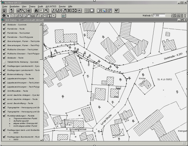
The Automated Real Estate Map includes graphic data of the Real Estate Cadastre like e. g. individual parcels with their boundaries, buildings, results of soil classification and the current use of landscape. The map is scaled in 1:1000 and it is parcel related. The respective parcels are identified by an individual parcel identification number. This data covers about 75 % of the area of Germany.
Figure 1 illustrates a typical example of ALK data. It contains information such as parcels and parcel identification number, political borders, different kinds of buildings, streetnames and soil classification.
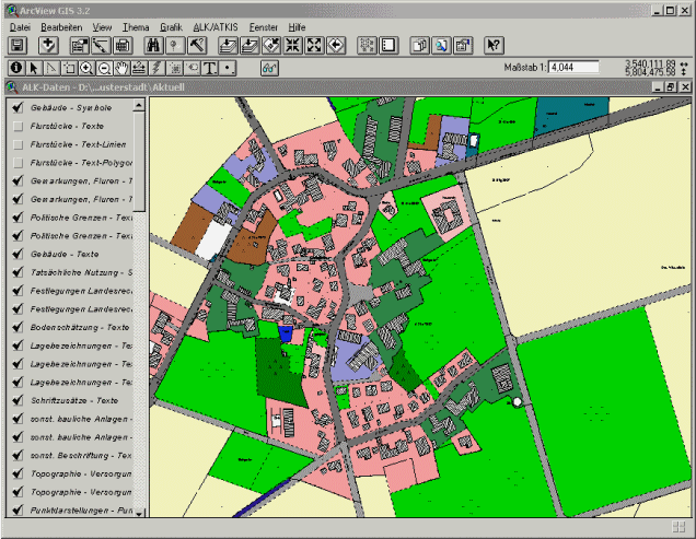
Figure 2 shows the same data from ALK, but illustrates the respective land use.
Hitherto, the ALK does not integrate alphanumeric data as e.g. information about the
ownership of a parcel.
This additional information is stored in the Automated Real Estate Register (ALB), which can
be displayed in a data base. Therefore, a connection (ODBC, DDE) between the GIS with the
Real Estate Map and the database including the Real Estate Register is required. The link
is made by the parcel identification number. For example, this connection is necessary to
identify all parcels of one specific owner. The resulting data is used to select matching
parcels and highlight them.
For reasons of data protection, the ALB is not accessible to the public.
The latest concept of the Real Estate Cadastre is ALKIS (Authoritative Real Estate Cadastre Information System), which integrates the alphanumeric (ALB) and graphic data (ALK) of the Real Estate Cadastre.
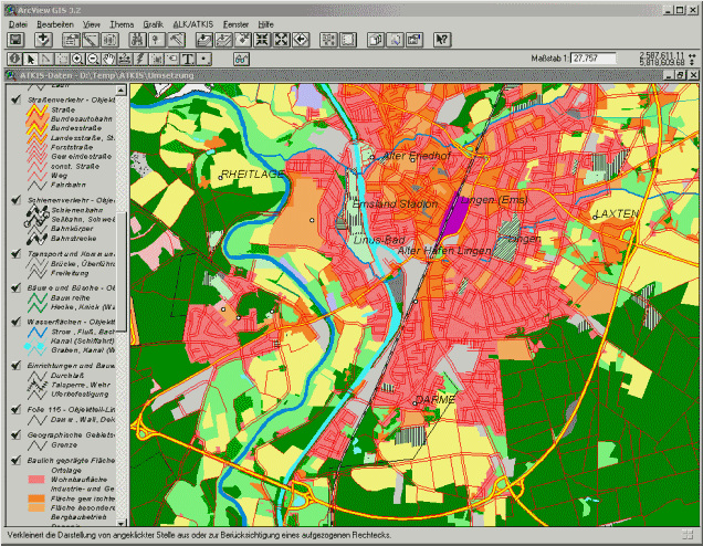
The Authorative Topographic and Cartographic Information System consists of the objectbased Digital Landscape Model (DLM), Digital Terrain Elevation Model (DGM), Digital Topograpfic Map (DTM) and standardised Digital Orthophoto (DOP). The DTM and DOP are raster data. The DLM is derived from the digitization of an analog map (scale 1:5000) in combination with orthophotos. Obtained data has an accuracy of +/- 3 meters. Its object oriented structure includes about 90 object categories and is available for the whole country. There are three phases of realisation. At present, the second phase of the realisation of the basic ATKIS-DLM is in progress, the third phase will probably start in 2002. The cycles of updating the most important objects, especially in the fields of road and railway construction, are very short (from a few months up to one year). For other objects the updating cycles take about five years.
An example for ATKIS-DLM is shown in Figure 3.
The format of the survey data is the EDBS (Einheitliche Datenbankschnittstelle).
This format is a special development for the survey data designed to be independent of
particular GIS and CAD-products.
For the use of this data in ArcView 3.2 or ArcGIS it is necessary to convert them to the
respective formats. As mentioned before, ALK and ATKIS-DLM data may be updated in user
defined cycles. The period of updating depends on the use of the data. Generally, only
information concerning areas that have undergone physical change will be replaced with the
latest data.
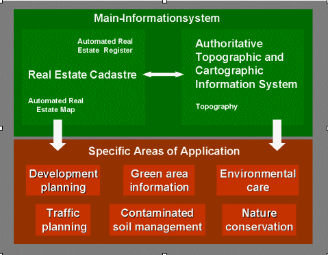
A municipality GIS is based on information from the Real Estate Cadastre and the Authoritive Topographic and Cartographic Information System (ATKIS). Combined, they form the Main-Informationsystem. Using this system, further specific areas of application in the fields of urban and landscape planning can be developed. For some situations ALK is more relevant, for others ATKIS-DLM is more appropriate.
Figure 4 illustrates the relationship between the two types of survey data and their use in field of urban and landscape planning.
Example 1:
In the field of urban planning the planner uses the Automated Real Estate Map (ALK) for
the preparation of the development plan on account of its accuracy and short updating-cycles.
But since the ALK does not contain any topography it is helpful to also use the Digital
Landscape Model (ATKIS-DLM).
For the creation of a development plan, the digitization of new objects is hardly necessary,
because it is possible to align new objects by joining parcels. If the border of a parcel
does not correspond to a border of a new area, the planner has to digitize a new object. The
constructed development plan, which is built on the ALK has as a result a high level of
accuracy and the data capture is faster and more efficient.
Because of the very short updating-cycles of the ALK, the municipality is able to easily
monitor the progress of the realisation of the development plan. The user has the possibility
to compare the development plan with the updated ALK. This is also a way to check if
conditions stipulated in the development plan were respected (e.g. dimensions of buildings
or distances from borders).
The usage of GIS in landscape planning requires the presentation of an extensive and accurate representation of the real landscape. While the information contained in raster data is usually not sufficient for complex analyses, the vector data based Digital Landscape Model (ATKIS-DLM) already includes a lot of important geographical objects. Therefore, these spatial data form a better basis for first analyses and further investigations.
Example 2:
In Germany, whenever a new street or railway is built, whenever new industrial or
commercial areas are planned, planning procedures are applied, which should assure that
the interests of the public community and the environment are not violated.
If a municipality wants to build a new road, it has to carry out an environmental impact
assessment. In this process, the optimal location for the route has to be determined. With
the data contained in the ATKIS-DLM it is possible to initially recognize areas to exclude.
These excluded areas may be lakes and rivers, conservation areas, water reserves or forests.
On account of vector data, a buffer as a typical GIS-function may be applied to define a
zone around residential areas, so that the route will not cause e.g. noise pollution for the
inhabitants. After the analysis and interpretation of the digital landscape model, the
result is a route for the road, which is less harmful to the environment. However, further
detailed investigations are necessary to still optimise the suggested run of the road.
The combination of survey data and subject specific data enables the user to solve complex environmental and urban problems and to find new solutions and viewpoints. ALK and ATKIS-DLM data include a lot of important basic information. With a GIS it is possible to select that piece of information from the information-pool of ALK and ATKIS-DLM, which is helpful to create maps for special questions and analyses.
Another important aspect is the data management and the maintenance of the survey data.
In a municipality the mentioned data must be available for all departments. The access to
the data must be user-friendly and up to date. A server for the spatial data is an efficient
tool to achieve this. Therefore, a server should be implemented to store the survey data and
also the subject specific data from different departments. While all departments have access
to the survey data, the access to specific data could be limited for reasons of data
protection.
The server organizes and provides a fast and reliable access to the desired data. The central
storage of the data facilitates maintenance, as only one database exists, which has to be
updated. This ensures that all departments of the municipality always work with the same
updated data. In contrast to the specific data, the survey data should be always
write-protected, because this data should not to be able to be edited by the user.
Depending on the requirements of the user different kinds of access to the server is
practicable. If access is through the Internet Mapserver Technology it is possible to use
the database as an Informationsystem. For further execute planning especially in the field
of urban and landscape planning a GIS is recommended.
Increasing demands on German municipalities in the field of urban and landscape planning require the use of a GIS. Therefore, it is essential to have survey data of high quality as a basis for analysis and the building up of subject specific data. Working with survey data demands certain rules for data management. The central storage of the database facilitates the data management and also the maintenance of the data.