This paper presents the current and future application of GIS technology in the Canadian Ice and Marine Service (CIMS). CIMS provides timely and accurate ice information for day-to-day decision support in Canadian waters. The acquisition, processing and integration of real time data is essential for this task. Since 1995, the Ice Service Integrated System (ISIS) in Ottawa, Canada has successfully processed significant volumes of diverse digital data within the fixed constraints of a daily production and delivery schedule.
This paper explores the migration of mission-critical ISIS technology into even more challenging physical environments such as remote offices, aircraft and icebreakers.
 The
economy of Canada is vitally dependent upon water transit.
Each year, ships face a deadly peril traveling the waters of the Canadian
Maritimes and Arctic. Ice floes and icebergs clog fresh and saltwater
shipping lanes, delaying transit and creating hazards for both ships and
those onboard. These environmental conditions have caused some
of history's more famous maritime disasters - most notoriously the Titanic,
which struck an iceberg on its maiden voyage and sank off the coast of
Newfoundland in April, 1912.
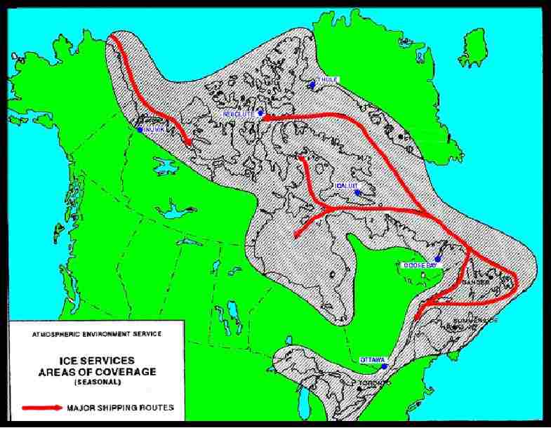
Consequently, the Canadian government places a premium on studying and understanding the dynamics of sea ice formation and drift. The Ice and Marine Services Branch (IMSB), a department of the Meteorological Service of Canada (MSC) , provides the Canadian Coast Guard as well as commercial vessels and oil rigs with accurate and timely reports of sea ice conditions for the East Coast of Canada and the Canadian Arctic. Headquartered in Ottawa, the purpose of the IMSB is to improve maritime navigation in Canadian and international waters, provide crucial environmental information of pack ice in Canada's northernmost regions and assist wherever possible in economic development.
To fulfill its mandate, the IMSB is highly dependent upon integrated Geographical Information Systems and supporting information technologies for the acquisition and efficient processing of data from satellites, airborne radars and other data sources.
ISIS was conceived in 1992 when the IMSB began its search for a replacement to its proprietary legacy systems. From the outset, the intention was to establish a framework for a generic decision support system. By definition, a generic system gives a general architecture as a starting point in contrast to a specific system which focuses on the available data (Haagsma and Johanns, 1997). A major advantage of a generic system is that it can be designed to simulate and closely support existing business processes and it can also be continuously adapted to conform to evolving organizational situations. A specific system, on the other hand, is designed to handle one particular set of applications and cannot be easily modified to deal with changing requirements.
ISIS is therefore generic in nature, employing a modular philosophy for all its components and sub-systems. An open, distributed architecture avoids the restrictions of platform dependence and facilitates access to data stored either directly on an ISIS server or to remotely located data via the Internet. Integration is achieved through metadata standards and the capabilities of commericial-off-the-shelf packages in a client/server environment.
This approach has satisfied the IMSB requirement for a system which was cost effective to implement and reliable in a production environment, as well as being flexible and scalable enough to adapt to new data sources, products, platforms and evolving business requirements.
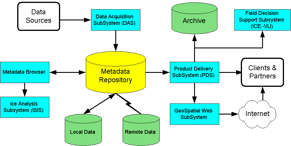
ISIS is comprised of a number of distinct subsystems, several of which integrate the functionality of ERDAS and Esri packages via custom interfaces. Subsystems include; Data Acquisition SubSystem, Metadata Repository with Browser, Ice Analysis SubSystems and Product Delivery SubSystem

Specifically, the Data Acquisition SubSystem provides the following functionality;
The Metadata Repository is composed of
The Federal Geographic Data Committee (FGDC) has developed a Content Standard for Digital Geospatial Metadata (CSDGM), which is used to describe geospatial data. The CSDGM standard defines a set of data elements that correspond to the data being described. CSDGM compliant metadata is stored within the ISIS Metadata Repository.
The data represented by the Metadata Repository does not need to exist within the Repository. Only the metadata describing the content, quality, condition, history, handling and access of the associated data object is required. Because the Repository uses metadata to reference data objects, the provider can maintain complete ownership and control over the data. By using the metadata reference, the co-ordination of data revision and exchange is greatly simplified. Although most data is accessed locally, metadata records can reference remote data.
In the ISIS model, the metadata pointer for locating the associated data object is accomplished with a Uniform Resource Locator (URL), which is the standard for the World Wide Web. The URL is the unique address of the data object, allowing the metadata and data to be stored in completely different infrastructures and locations. Along with the location, the URL defines the access protocol to assist in the transfer of the data object for either remote data (e.g. HTTP:// or FTP:// or Telnet://) or local data (File://).
Access to the Metadata Repository is made available only through a set of application interfaces known collectively as the Metadata Manager. Security is guaranteed and all new or updated metadata entries are subjected to a thorough quality assurance evaluation. The deletion of records from the Metadata Repository is controlled by the Metadata Manager.
The Browser presents the user with a consistent view of the repository and provides the tools necessary for displaying and manipulating selected sets of records from the metadata repository. Filtering metadata by theme, by location, by time and by attributes is provided along with the standard display functions for changing the area of interest (zoom-in, zoom-out, roam, etc.) At the same time, the Browser isolates the user from the implementation details of the repository and the data objects.
Most importantly, the format and location and status of the data object is irrelevant when displaying the affiliated metadata record and its visual footprint. All resources necessary for the Browser to function are provided by the Metadata Repository.
Recalling that with geospatial metadata the "footprint" of the data can be superimposed on a globe, the Browser allows the user to see the geographic extent of the data object, thereby helping to present more effectively the context of the data. The Browser also supports the review of imagery as thumbnail pictures.
The Ice Analysis SubSystem is the high-end, fully functional ISIS workstations which provide analysts based in Ottawa with access to all data referenced by the Metadata Repository. Custom tools have been developed for sorting, displaying and analyzing data in order to generate electronic and hard copy products such as charts (image analysis, ice analysis, navigation) and bulletins. The subsystem enables analysts to enhance imagery and then annotate with text and line objects to reveal ice characteristics. Automated validation and quality control capabilities are an integral component . This subsystem is UNIX or Windows NT based and makes extensive use of ERDAS Imagine and Esri ArcInfo software.
The Field Decision Support Subsystem is the low-end ICE-VU workstations which were deployed on Canadian Coast Guard vessels and to remote ice operation offices. ICE-VU workstations were designed specifically as shipboard end-user applications and provide Coast Guard and Ice Operations staff with the capability to receive real-time SAR/SLAR data or to download compressed MrSID imagery. ICE-VU are stand-alone systems and have their own basic data acquisition and cataloging functions to enable the user to plan navigation routes and deviations. This subsystem is Windows NT based and makes extensive use of ERDAS Imagine software.
Specifically, the Product Delivery SubSystem provides the following functionality;
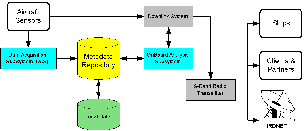
As well, a new ISIS subsystem is currently in the design stage. This is the OnBoard Analysis Subsystem and it is intended to have capabilities between the high-end ISIS and low-end ICE-VU Ice Analysis Subsystems. Visual data entry will be based on pen computers that will use GIS technologies for attribute and feature inputs. Data integration and analysis will be based on the Ice Analysis Subsystem.
Although satellite imagery has become the primary data source for IMSB, reconnaissance by aircraft remains a complementary and flexible method of collecting ice and iceberg information. Equipped with SAR/SLAR sensors, observation bubbles, infra-red detectors, laser profilometers and digital video cameras, the aircraft can provide a very comprehensive report of a specific area or shipping lane.
To assist the IMSB personnel on the aircraft, the OnBoard Analysis Subsystem will be configured with a small network linking a server and one or more workstations. This allows the analysts to interpret newly processed SAR/SLAR imagery in near real-time, generate an analysis enhanced by visual and other sensor data, and then downlink the product directly to Coast Guard ships, commercial ships or satellite broadcast stations. This subsystem will be Windows NT based and will make extensive use of ERDAS Imagine and Esri ArcInfo software.
Beyond their standard ice duties, there will be opportunities in which aircraft equipped with the OnBoard Analysis Subsystem could assist in disaster assessment (flooding, pollution), wildlife management (seal counts) and possibly law enforcement (drug interdiction).

Most importantly, ISIS has enabled Coast Guard, merchant marine and port operations personnel to make better decisions, maximizing safety and keeping commerce moving in Canadian waters..