Development of GIS-Based Illinois Highway Pavement Management System
Ghulam H. Bham, Nasir G. Gharaibeh and Michael I. Darter
Esri User Conference,
July 9 -13th, 2001,
San Diego, California
ABSTRACT
The paper describes the development of a GIS-based pavement management system for the State of Illinois. The system is anticipated to considerably improve the decision-making process involved in managing pavements. Current and historic pavement data for the interstate highway network is used by the system which employs engineering and economic analysis procedures to aid in the development of the multi-year highway improvement program. The system utilizes pavement condition, construction, rehabilitation, and traffic data for conducting the analysis. It employs models that predict pavement and traffic conditions in the future and is capable of developing optimum pavement rehabilitation plans for the future. The system is developed in ArcView GIS and the base map is developed in ArcInfo GIS.
INTRODUCTION
Highway infrastructure facilities in the United States represent a large investment that is essential for the movement of people and goods. It stands to reason, then, that the quality of the highway network is an important factor in the economic growth of the country. Pavement surfaces are a major component of this infrastructure and greatly affect the comfort, costs, and safety of highway users.
The Illinois Interstate system includes over 1400 different pavement sections, totaling over 3000 centerline kilometers (1900 miles). Most of these sections were built during the 1960s and 1970s and have experienced severe climatic conditions and much higher traffic loadings than they were designed for. Many of these pavement sections have been rehabilitated or reconstructed during the past two decades, some of them have been rehabilitated several times, and nearly all of them will be rehabilitated again over the next 5 years (1).
The Illinois Department of Transportation (IDOT) has a long history of proactive pavement management. In the early 1980s, IDOT began to invest in several projects in order to allocate resources more effectively. In the early 1980s, the Illinois Pavement Feedback System (IPFS) (2) and the Illinois Roadway Information System (IRIS) were developed to store roadway inventory and condition data. IDOTís first pavement management system (PMS), ILLINET (3,4), was completed in 1992, and a Microsoft® Windows® version (5) was introduced in 1994. With the advent of geographic information systems (GIS), IDOT decided to transfer the capabilities of ILLINET to a GIS-based PMS and expand the database to include non-Interstate pavements. IDOT initiated its development in 1998, and the first version of this system was completed recently. This paper provides an overview of the development and capabilities of the GIS-based PMS system called ILLIPIMS.
ILLINOIS GIS-BASED PMS SYSTEM
The Illinois Pavement Information and Management System (ILLIPIMS) has been developed in Esri's ArcView® GIS 3.2 (6) and the base map was developed using Esriís ARC/INFO® (7). The system is built on the experience of ILLINET. ILLIPIMS utilizes the same data as used in ILLINET, updated to the current available data and modified to suit ArcView's database format.
Work on ILLIPIMS was carried out in four stages. The first stage consisted of data acquisition and updating the IRIS and IPFS databases. The second stage involved implementation of prediction capabilities in the system. The third stage involved incorporating analysis procedures for developing multi-year rehabilitation programs. The final stage includes incorporating individual districts of Illinois and their pilot implementation, and non-Interstate roadway network.
ILLIPIMS is capable of analyzing, modifying, reporting, predicting and displaying pavement and traffic information for the entire Interstate system of Illinois. The system can display information spatially as well as temporally. Spatial information on traffic, type of pavement rehabilitation, and pavement condition is presented direction wise (North/East, South/West) for the highway system in the form of different themes. Temporal information is displayed based on user selection of a particular year. Moreover, any section of the interstate map can be selected and its graph plotted showing the historical trend of the displayed data.
ILLIPIMS contains historic data for Annual Average Daily Traffic (AADT), Equivalent Single Axle Loads (ESAL), Condition Rating Survey (CRS), International Roughness Index (IRI), rutting, information on pavement rehabilitation, number of lanes, original type and thickness of pavement, type and thickness of overlay, and other relevant detail for every pavement section. Thematic maps for these variables can be generated for historic and predicted data. Thus the condition of the highway network can be observed over several years.
ILLIPIMS is unique because of its graphing and data displaying capabilities. Almost all information can be displayed either in maps, graphs, charts or tables. Color-coded dynamic legends are used to display and provide information to the user. Additionally, it is possible to zoom in on a particular section or highlight it by selecting it from an attribute table. Similarly, by selecting a section, its attributes can be highlighted in a table.
ILLIPIMS utilizes weighted benefit ranking procedure and prediction models for traffic, rehabilitation, and pavement condition. The models developed and incorporated in the system can predict 20 years in the future, and the user can change the input parameters to these models. The user has the option of selecting traffic growth rates for the future or use average growth rates from historic AADT data. Both simple and compound growth rates can be used, as well. In addition, it can generate multi-year pavement rehabilitation programs based on the weighted benefit ranking procedure, which is described in the next section. IDOT uses this system to help make more cost-effective decisions, increase staff productivity, and increase customer (public) satisfaction.
The system is simple and user friendly. Several user interfaces are provided which aid in entering data and carrying out analysis. The user interface were developed using the "Dialog Designer" extension of ArcView, in which dialogs were created and then simple scripts written in Avenue (ArcViewís object oriented programming language) attached with label and tool buttons, lists, and combination boxes. No prior training in ArcView GIS is required to use the system. The dialogs are explained in the following sections.
DEVELOPMENT OF MULTIYEAR IMPROVEMENT PROGRAM
ILLIPIMS utilizes a weighted benefit ranking (WBR) procedure to prioritize pavement network level rehabilitation. The WBR procedure measures overall benefit of improving the condition of the pavement based on change in the Condition Rating Survey (CRS), International Roughness Index (IRI), and average rut depth, taking traffic into account. When the overall benefit exceeds a certain limiting value (1.0), the pavement is considered to be in a "backlog" condition and in need of improvement. The more the value is exceeded, the more critical the pavement backlog condition is and, therefore, the need for improvement.
Pavement sections with an overall benefit greater than the limiting value are selected for rehabilitation. These sections are prioritized in the order of their overall benefit. Sections with higher overall benefit are selected first and with lower overall benefit are selected last. The input parameters to the WBR procedure are described in the following section.
Weighted Benefit Ranking Procedure
WBR procedure is based on the overall benefit of improving the pavement section. Overall benefit is subdivided into individual benefits which depend on CRS, IRI and rutting (in case of asphalt surfacing). AADT is utilized to take into account use of the facility. The individual benefits are computed as:
CRSBenefit = Log (AADT/Lanes) * (9.0 - CRS)ÖÖ(1)
IRIBenefit = Log (AADT/Lanes) * (IRI - 50)ÖÖÖ..(2)
RutBenefit = Log (AADT/Lanes) * RutÖÖÖÖÖ..(3)
where
CRSBenefit = Benefit due to improvement in CRS
IRIBenefit = Benefit due to improvement in IRI
RutBenefit = Benefit due to improvement in rutting
Lanes = Number of lanes
CRS = Condition Rating Survey (Range from 1 to 9)
IRI = International Roughness Index, inches/mile
Rut = Rut Depth, inches
For AC surfacing the overall benefit is calculated as:
Overall Benefit = 0.5*CRSBenefit/a + 0.25*IRIBenefit/b + 0.25*RutBenefit/cÖÖ.(4)
where a, b, and c are calibrated parameters.
For PCC surfacing the overall benefit is calculated as:
Overall Benefit = 0.5*CRSBenefit/a + 0.5*IRIBenefit/bÖÖ.(5)
where a, and b are calibrated parameters. The calibration of these parameters is described next.
Calibration of Parameters
The calibration of parameters was carried out for the parameters a, b, and c, based on AADT per lane, CRS, IRI, and rutting values. Values of these variables were selected so that a pavement section that requires rehabilitation has an overall benefit greater or equal to the limiting value. The section would thus be selected for rehabilitation using the WBR procedure.
The ratio of AADT/lane was first analyzed and the minimum value of AADT was used from the latest year's AADT data. Minimum value was chosen so that the section with even the least value of AADT, but in condition that needs rehabilitation would be selected as backlogged.
Values for CRS, IRI and rutting were chosen below or above (depending on the condition index) which the users, engineers and the researchers perceive that the pavement section needs rehabilitation. These values are 6.0 for CRS, 175 inch/mile for IRI and 0.2 inch for rutting for all types of pavements. The parameters were then obtained by solving Equations 4 and 5 for an overall benefit of 1.0. The values of these parameters for asphalt and concrete surfacing are presented in Table 1.
Table 1. Calibration Parameters used in WBR Procedure
|
Pavement Surfacing |
CRS |
IRI in./mile |
Rut inch |
(AADT/Lane) |
Overall Benefit |
Parameters |
||
|
a |
b |
c |
||||||
|
Asphalt |
6.0 |
175 |
0.2 |
787.5 |
1.0 |
8.69 |
362.0 |
0.58 |
|
Concrete |
6.0 |
175 |
-- |
787.5 |
1.0 |
8.69 |
362.0 |
-- |
Capabilities of ILLIPIMS
ILLIPIMS is developed as a tool to aid in developing IDOT's multiyear highway improvement program. It uses current data and the input parameters entered through the interface for predicting future pavement rehabilitation and reconstruction requirements. The system can also be used to display and analyze both historic and forecasted values of CRS, IRI, rutting, AADT and ESAL's using thematic map. Similarly, different types of rehabilitation performed in the past and forecasted in the future can be displayed.
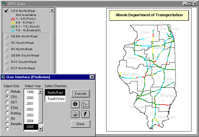
Figures 1 and 2 show examples of the systems capability to display thematic maps of historic and predicted CRS and the user interface. The user interface can be used for selecting parameters like rehabilitation, CRS, AADT, ESAL, etc., for a particular year and direction, and can be used for retrieving information on a section of the highway by clicking on the "i" button and then selecting a highway section from the map. The "graph" symbol shown in the figures can be clicked and any section of the highway can be chosen to plot a graph showing historical or predicted data. Figure 2 shows a plot of historic data only. The pie chart symbol is used for plotting the percent of highway sections rehabilitated in a particular year. Figure 3 shows the pie chart for historic rehabilitation data. The "lighting" symbol is used for initiating a web browser and displaying information on the World Wide Web for a particular section. Additional details of the application of the system for using the Web is provided in the following paragraphs, see Figure 5 for details.
Figure 1 shows the condition of the predicted network in year 2005 for the North/East direction. As can be seen, for the parameters used, the highway network shows some sections of the highway in red (poor), yellow (fair), green (good) and blue (excellent). The legend shows the range of the CRS used for classifying the condition of the pavement sections. Sections in gray represent unavailability of data. These sections represent toll roads that are not managed by the IDOT.
Figure 2 shows the condition of the network for the year 1998. The graph shows historic CRS data from the year 1986 to 1996 (10 years) of a section of the Interstate. The selected section is seen in purple on the Interstate highway map. The graph can be used to observe the trend of the pavement condition and provides very useful information to pavement managers with just the touch of a button.
Figure 1. Example thematic map of predicted CRS (Illinois's Interstate Highway)
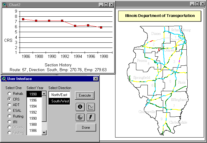
Figure 2. Example thematic map and chart of historical CRS data.
Figure 3 shows example of the system's ability to display thematic maps and charts of rehabilitation. The system is capable of displaying both historical and projected maps for pavement rehabilitation. The map in Figure 3 shows different types of pavement rehabilitation, presented in different colors, performed in 1996 on various part of the Interstate highway network. The pavement manager can use this information to observe the different locations and types of pavement rehabilitation to be performed in a year. Additionally, expected rehabilitation in the future can be observed and rehabilitation plans can be improved by properly planning rehabilitation on particular routes in a year instead of conducting the rehabilitation spread over multiple years. Planning rehabilitation will minimize traffic disruption on the selected route saving millions of dollars in terms of travel delay due to construction zones.
Figure 3 also shows the pie chart for percentage of construction and rehabilitation activities by type. In this graph, 'Local. Repaired' indicates patching and maintenance activity carried out for a particular year.
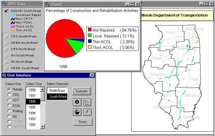
Figure 3. Example thematic map and chart of historical rehabilitation data.
Figure 4 shows projected AADT data for 2006 for the North/East direction. Different colors of the map show different levels of AADT on sections of the highway. Different levels of AADT are shown in the legend. The graph shows the plot of historic as well as projected AADT data for a selected section of Interstate route 55. The graph can be used to verify the correct use of traffic growth rate, observe the trend and level of traffic for a particular section of the highway.
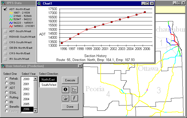
Figure 4. Example thematic map and chart of projected ADT.
ILLIPIMS can provide an important application of the World Wide Web in storing and sharing data on the Internet in the future (Figure 5Figure ). Pavement images can be stored on a web server that can be easily displayed using a web browser. Users from every IDOT district office can access these files at any time. These images can provide updated information about distresses, lane closures, and traffic-related data. In addition, data can be updated frequently and at a much faster pace. The data site can also be used to download data on individual machines when required.
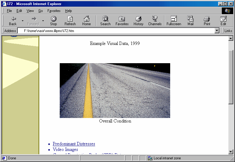
Figure 5. Example of Web interface showing distress in pavement
Implementation of Individual Districts
Figure 6 shows pilot implementation of the system for one of the districts (District 5) in Illinois. The figure shows incorporation of US and State routes in addition to the Interstate routes. Currently CRS, IRI, rutting, faulting, and AADT data is available. In the future, additional data such as rehabilitation history and ESAL data will be added to the district maps. Pavement management at the district level will improve the condition of secondary routes in addition to the primary routes such as the Interstate highways.
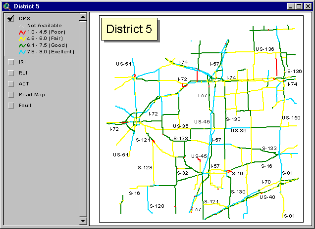
Figure 6. Implementation of the System for Individual Districts
To summarize, ILLIPIMS can be used for conducting several different types of data analysis, such as:
The traffic data available can be used for a variety of purposes, such as:
Design of User Interface
This section describes in detail the design and input to the user interface developed using ArcView's Dialog Designer. The user interfaces are user friendly and makes the pavement management system easy to use. The system is developed for managers and engineers at IDOT, and being easy to use would be easily accepted at the IDOT.
An essential element in any pavement management system is the pavement performance prediction model. Prediction models are used to estimate future pavement condition, the resulting maintenance and rehabilitation needs and budget requirements. The Illinois DOT measures pavement deterioration using the CRS method, which is a pavement condition index that rates a pavement section based on the distresses present. Using this method, pavement sections are assigned a numerical rating from 1 to 9, with 9 assigned to a newly built or resurfaced pavement. The CRS rating represents both the experienced engineerís perspective of the pavement and usersí concerns. CRS has been used by the Illinois DOT for the last twenty years. Figure 7 shows the user interface and the input parameters used in the model. Default values for the model can be used, else different values can be entered as well. Illinois is divided into two main regions, mainly districts 1 to 4 in the North and districts 5 to 9 in the South. Different deduct values are used in the CRS prediction model for different types of pavements. Similarly different adjustment factors are used. Adjustment factors are provided for D-Cracking, a type of distress found in pavements in the Midwest region of the US. Similar user interfaces are provided for prediction models of IRI and rutting.
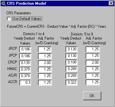
Figure 7. User Interface for CRS Prediction Model
Figure 8 shows the user interface for entering traffic growth rates for AADT and ESAL. These growth rates are used in the WBR procedure for determining the overall benefit and then prioritizing the selected sections for rehabilitation. Both simple and compound traffic growth rates can be selected using the drop down menu, as shown in the figure.

Figure 8. User Interface for entering traffic growth rates
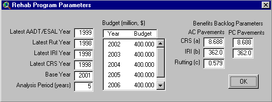
Figure 9 shows the user interface for multiyear improvement plan. The base year, analysis period, yearly budget and benefit backlog parameters are all inputs to the WBR procedure. The system is flexible as 'latest years' for every input parameter can be changed as newer data is added to the system. Base year is also a variable. The year column is updated according to the base year and budget can be entered for individual years by clicking on the budget column.
Figure 9. User Interface for Multiyear Improvement Plan
Project level analysis determines the type of rehabilitation required for a pavement section. The decision tree method uses CRS as cutoff points to determine the type of rehabilitation required for a pavement section. Five alternatives are available for improving the condition of 6 different types of pavement sections. These alternatives are maintenance, patching, 3-inch asphalt overlay, 5-inch asphalt overlay and CRCP (Continuously reinforced concrete pavement) reconstruction. CRCP reconstruction is required for pavement sections that have the lowest CRS and in worst condition.
The user interface for rehabilitation decision tree is shown in Figure 10. According to the values in the user interface a JRCP (Jointed reinforced concrete pavement) section with a CRS below 1.0 would require reconstruction as a CRCP pavement. Similarly, a JPCP (Jointed plain concrete pavement) section with a CRS below 4.9 would require a 5-inch asphalt overlay. The CRS cutoff values determine the type of rehabilitation for a particular type of pavement section.
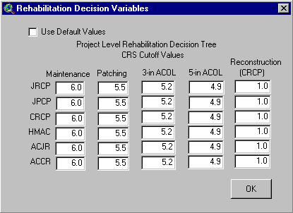
Figure 10. User Interface for Decision Tree Parameters
Figure 11 shows effects of pavement rehabilitation on the values of CRS, IRI and rutting. Again default values can be used or they can be altered as desired. The effect of rehabilitation depends on the type of surfacing; asphalt or concrete and the type of activity; patching, 3 or 5 inch asphalt overlay or reconstruction. In case of an overlay or reconstruction the values are changed according to the entered values. For example a pavement section with a CRS of 4, an IRI of 250, and with rutting of 0.35 will be updated to CRS value of 9, IRI of 60 and no rutting will be present, if it is reconstructed as CRCP (see 5th column of the user interface). However, in case of patching only relative change occurs in the condition of the section. CRS increases by 1, whereas IRI and rutting values reduce by 20 and 0.1, respectively, according to the values in the user interface, see Figure 11.
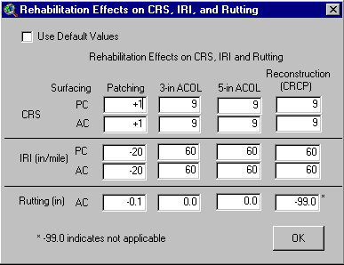
Figure 11. User Interface showing rehabilitation effect on CRS, IRI and rutting.
Figure 12 shows the user interface for entering unit cost per lane mile for different types of rehabilitation. The default unit costs for year 2000 are provided in the interface and values can be altered as desired by the user. Inflation rate for unit costs of future years of rehabilitation can also be entered using the interface.
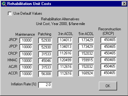
Figure 12. User Interface for units costs of rehabilitation
Application of GIS in HIGHWAY Infrastructure Management
A highway infrastructure network consists of many components (e.g., pavements, bridges, culverts, signs, intersections, curbs and gutters) that are normally owned and managed by the same agency. Thus, it is logical to expect that managing these components in a coordinated manner is beneficial to the users and owners, particularly where it is critical to minimizing lane closures. Highway infrastructure management is essentially a set of activities associated with the process of maintaining, rehabilitating, and reconstructing/replacing highway assets in a cost-effective way. GIS-based highway infrastructure management systems allow highway agencies to perform a coordinated management of their assets and provide the services that the public expects of them within funding limits.
The next generation of ILLIPIMS would include expanding this pavement-oriented system to incorporate other highway infrastructure components, such as bridges and signs. The engineering and spatial analytical methods that were implemented in a previous prototype would be migrated into the next generation of ILLIPIMS (8).
CONCLUSIONS
The developed system shows the benefits of integrating GIS with PMS. GIS is an effective tool for integrating, managing, querying, and spatially analyzing transportation data. Moreover, it provides an efficient means for interpreting and displaying empirical trends and patterns in transportation data. The ILLIPIMS system contains unique mapping and graphing capabilities, allowing IDOT to display, analyze, and update data for the entire Illinois Interstate highway network more efficiently.
ACKNOWLEDGMENTS
The authors wish to thank the Illinois Department of Transportation for providing financial support for conducting this research. The contents of this paper reflect the view of the authors and do not necessarily reflect the official policy of the Illinois Department of Transportation.
REFERENCES
AUTHORS
Ghulam H. Bham
Ph.D. Candidate
Department of Civil Engineering
University of Illinois at Urbana-Champaign
Urbana, IL 61801
Fax (217) 333-9464, Phone (217) 333-6975
E-mail: bham@uiuc.edu
Nasir G. Gharaibeh, Ph.D.
Senior Engineer
ERES Consultants, a Division of Applied Research Associates, Inc.
Champaign, IL 61820
Fax (217) 356-3088, Phone (217) 356-4500
E-mail: ngharaibeh@ara.com
Michael I. Darter, Ph.D., P.E.
Principal Engineer
ERES Consultants, a Division of Applied Research Associates, Inc.
Champaign, IL 61820
Fax (217) 356-3088, Phone (217) 356-4500
E-mail: mdarter@ara.com