Now citizens of Merano, a small Town of 35,000 people in northern Italy, can get a number of documents and certifications faster and easier. This goes from extracts of the Urban Master plan to certificates stating the length of the school way for children, to cadastral or topographic maps, aerial photographs or all these overlaid and combined. Decision makers have new tools to plan the development of the town and the services for the citizen.
All this is now possible because of the recent introduction of GIS in the local administration of Merano, as a pilot project for the 116 municipalities of South Tyrol, a mountain district of northern Italy. South Tirol is located in the Alps at the border to Austria and Switzerland. It covers an area of approximately 740,000 ha ranging from 200 to 4,000 m altitude. The 465,000 people living in South-Tyrol speak three different languages, German, Italian and Ladin, an old language related to ancient latin.
In January 2000 the town of Merano started developing together with the S³dtiroler Gemeindenverband (SGV), i.e. the association of the Municipalities of the country, and the district capital of Bolzano (100,000 inhabitants), a strategy to introduce GIS in the local administration [3]. Given the particular situation of the district ¢ two and in some areas even three official languages, different laws from the central Government in Rome because of itÆs autonomy, etc. ¢ SGV plays a central role in providing technical backstopping to the single and mostly very small municipalities.
The Town of Merano had already started in 1997 to re-survey the whole territory and has produced a new set of highly accurate 3D topographic maps in scale 1:1000. In addition it invested in experienced personnel to make sure the new geographic data is used throughout the administration and linked to all existing tabular data. These resources made Merano the best terrain to test the new GIS Strategy and applications.
The central architecture of the GIS System consists of a GIS Database which includes Geodatabases, shapefiles, CAD Drawings, aerial photographs and any other available geographic data, linked to the Oracle database of residents and to the parcel data from land registry. Different Applications interact with the database in order to query and display the data (ArcView, ArcIMS), import, export and edit the data (ArcInfo, AutoCAD) or analyse the data (ArcInfo, ArcView, 3D Analyst).
The users of geographic information in the Town administration have a clear pyramidal structure with few power users and many basic users. The basic users mainly visualise the data, query it, carry out customised searches and print customised layouts. In rare cases they carry out distance and area measurements. A brief analysis of the different users and their quantities is given in Table 1.
|
User |
Main operations carried out with geographic data |
Quantity |
|
GIO |
System administration, GIS data preparation, application development |
1 |
|
GIS/CAD Experts |
Data entry and maintenance |
3 |
|
Planners |
Data visualisation, custom queries, custom certificates, measurements |
10 |
|
Users from different offices |
Data visualisation, query and standard printouts |
100 |
One of the applications being developed in the Municipalities was initially based on ArcView and allowed to view and query several geographic maps relevant for urban planning and building specifications. The introduction of this application in only two offices of the municipality allowed the automated production of a number of certificates dramatically reducing production time.
ArcIMS was selected to spread the usage of GIS through the different offices of the administration, giving access to it to a wide number of offices. At the same time through a dedicated extranet among all Municipalities of the region, SGV is making GIS data available geographic information to municipalities which donÆt have the manpower and resources to implement their own GIS.
One of the main applications which was developed in the Town of Merano is a personalized data browser in ArcView which allows the display of a number of different geographic data layers, the connection to the main Oracle database of residents and the production of standard certificates. The application is called URBANINFO, since it extracts information on different urban aspects of the city. The core is an ArcView application, personalized in Avenue, which combines different sets of geographic data and the central database of residents on Oracle, and queries them in different ways in order to produce customized certificates and printouts. Many of the functions available in Urbaninfo can be implemented in an ArcIMS environment easily.
Fig. 1 shows the structure of the application ōUrbaninfoö and the available outputs. The last two outputs and the link to MS Word and Ghostview are not available on the current ArcIMS version (this is indicated on by a grey box).
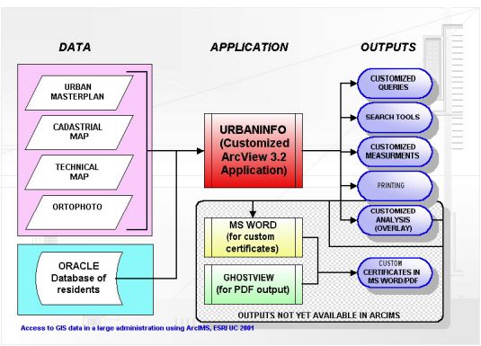
Fig. 1: Structure of Urbaninfo and outputs currently not available on the ArcIMS version.
The set-up of the ArcIMS service can be split in following steps:
The Town purchased a dedicated GIS server and installed on it the Apache Web Server with ApacheJServ/1.1.2 and ArcIMS 3.0. SGV installed a similar server with the same software configuration to give to the smaller municipalities access to GIS data. The GIO and GIS Officers of the Town and the SGV participated in a three day training in ArcIMS.
The data was then converted in order to make it suitable for use in ArcIMS. The standards applied for the data had been previously defined with the Association of the Municipalities of South Tyrol [1][2]. This applied particularly to CAD data which was converted to shapefile format. In addition some of the shapefiles were merged in order to reduce the number of layers.
In order to set-up the mapservice an AXL file was created assigning to each layer the proper legend and linking the tables of the shapefile to the databases. This process was carried out using a simple text editor.
The standard HTML Viewer was customised in order to include following tools:
A screenshot of the Mapservice is given in Fig. 2. The main missing function is the production of standard certificates, which will be implemented on future upgrades of the Mapservice.
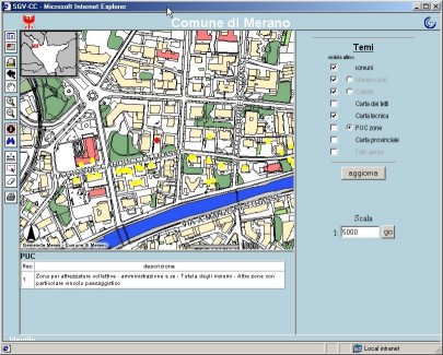
Fig. 2: A screenshot of the mapservice
Compared to the original Urbaninfo application the ArcIMS Mapservice can completely satisfy the users from different offices (about 100 people) mentioned on Table 1 and partly satisfy the Planners (10 people), thus reducing the need for ArcView installations to a limited number of people. It also allows for a better and deeper integration of geographic data into all offices of the town administration, since the marginal cost for each additional user is almost zero.
The use of ArcIMS mapservices has proven very effective and efficient in the Municipality of Merano and in the other towns connected to the extranet of the SGV. In addition to rationalizing maintenance of the GIS database and improve access to data, it has revolutionized the use of geographic data in the administration. Almost any PC is now able to access the main geographic layers and this information is used increasingly in all aspects of the administration.
The success with the Urbaninfo application has led to plans for other map services in ArcIMS on the Intranet and Internet in the near future.
[1] S³dtiroler Gemeindenverband, 2000. "Numerische Kartographie in den Nominalma▀stõben 1:1000 und 1:2000 Technische Einzelheiten". Technical report.
[2] T. Coianiz, F. Gambalonga, P.Viskanic, in press. "Dalla Cartografia Numerica ai Sistemi Informativi Territoriali". Rivista del Dipartimento del Territorio. Tipografia del Genio Civile.
[3] P.Viskanic, T. Coianiz. "GIS in the Local Administration in South Tirol, Italy". In proceeding of the Esri European, Middle Eastern, and African User Conference 2000.
[4] Plewe, Brandon "GIS Online: information retrieval, mapping and the internet". Onword Press, 1997
Paolo Viskanic
Municipality of Merano, Italy
Geographic Information Officer
Via Portici, 192 - I-39012 Merano - Italy
pviskani.meran@gvcc.net
Tarcisio Coianiz
Association of the municipalities of South Tyrol, Italy
Geographic Information Officer
Viale Stazione, 5 - I-39100 Bolzano - Italy