Robert Brundage
ABSTRACT:
Two years ago the City of Clarksville, Montgomery County and Austin Peay State University in the state of TN joined a tri-party agreement to take advantage of the state’s Department of Property Assessments ‘Base Mapping Project’ of automating TN counties Assessor of Property’s offices throughout the state using GIS technology. The task has been to take the data delivered and maintained by the Assessor of Property’s Office and share it with other city/county departments. The task has also been to implement some type of ‘Enterprise’ GIS for Clarksville/Montgomery County where all departments can access geographic data and contribute data to the system for other departments.
The Clarksville/Montgomery County GIS Center is well on the way to achieving this goal. Through a common directory/data structure and the use of system environment variables the CMCGIS Center is currently supporting 16 city/county departments with near-real time data and applications as they are developed. With some city/county departments having modern departmental computer networks while other departments using Pentium 286 computers that are stand alone computers, what do we use to establish an ‘Enterprise’ GIS? We established a ‘Shoestring Enterprise’ GIS through the use of ArcView, MapObjects and ArcIMS. Find out what brand of tennis shoes we wear to make this happen? How did we develop a relatively in-expensive solution for smaller city/counties to take full advantage of GIS technology with an ‘Enterprise’ type solution.
Environmental Statistics:
Montgomery County has an area of ~542 sq miles; a population of ~150,000. There is one incorporated area. This is the City of Clarksville. The population of Clarksville is ~100,000 with an area of ~95 sq miles. There are basically 2 main local governments, the city of Clarksville government and the Montgomery County Government. A next minor governmental body is the joint Clarksville/Montgomery County School System. Each one of these entities has its own Information Services Department providing computer support to the departments within its organization.
Here is a list of City/County/Commercial Agencies that are participating in the ‘Enterprise’ GIS or have expressed interest in participating in the ‘Enterprise’ GIS.
|
Montgomery County Departments |
City of Clarksville Departments |
|
Highway Department* |
Street Department* |
|
Building & Codes Department* |
Building & Codes Department* |
|
Sheriff’s Department* |
Police Department* |
|
County Executive Office* |
Mayor’s Office* |
|
Information Systems Department* |
Information Systems Department* |
|
Emergency Management Agency* |
Fire Department* |
|
Parks & Recreation Department* |
Parks & Recreation Department* |
|
County Trustees Office* |
City Finance & Revenue* |
|
Assessor of Property |
Gas, Water, & Sewer Department |
|
Election Commission |
City Engineer |
|
County Clerk |
City Transit System |
|
Health Department |
Cemetery |
|
|
City Parking Authority |
|
|
|
*Redundant departments between city and county government.
|
Joint Clarksville-Montgomery County Agencies |
|
Clarksville-Montgomery County School System Plant & Facilities Department |
|
Clarksville-Montgomery County School System Transportation Department |
|
Regional Planning Commission |
|
City/County Emergency Medical Service (Ambulance) |
|
City/County E-911 Dispatch |
|
City/County Rescue Squad |
|
Entities that are not under scope of contractual services |
|
Cumberland Electric Membership Corporation (County Power Company) |
|
City of Clarksville Department of Electricity |
|
City of Clarksville Economic Development Council |
|
Ft. Campbell Army Base Public Works Business Center |
|
Ft. Campbell Army Base Public Works Environment Division |
|
Ft. Campbell Division Of Groundwater Protection |
|
Bi-County Solid Waste |
|
Cunningham Utility District |
|
East Montgomery Utility District |
|
Woodlawn Utility District |
|
Bell South Telephone Company |
Clarksville/Montgomery County GIS Center Defined:
What do I mean by ‘Shoestring Enterprise’ GIS?
Shoestring. I use the word shoestring because the current structure of the GIS is based on lower end technology solutions… ArcView shapefiles, Arc/Info Librarian structures, a state provided FOXPRO database viewer and CAMA, with a Compact Disc (CD) delivery system made by personal visits to city/county departments. VERSUS. A modern ‘Enterprise’ GIS with a Spatial Database Engine (SDE) and Relational Databases (Oracle, SQLServer…) with live access to information through a community wide fiber network.
I think it is necessary to state that if you do not have a modern computer environment i.e. existing departmental networks, cross departmental networks, modern computers, computer literate employees, expertise to maintain the above… then you cannot go to the higher end solutions without dropping out potential users due to equipment/budget/expertise problems. If you do try to serve all potential (high end/low end) users you end up setting up numerous complicated mechanisms that you are left to manage. Which I think would not be fun or possible with limited staff. So therefore the ‘shoestring’ word along with ‘Enterprise’.
Enterprise. I use the word ‘Enterprise’ just in the since of GIS. The idea in our case was to establish an environment where participating city/county departments had access to each others GIS databases as near to real-time as possible. The definition of ‘Enterprise’ where a city/county department has all it’s information in one RDBMS serving all needs of the department OR one huge RDBMS serving the needs of every aspect of all departments within the city/county was not the goal.
The GIS Center did not create any new techniques, technology or methodology in its ‘Enterprise’ GIS implementation. The GIS Center did a good job of understanding and taking advantage of the technology tools at hand to develop a working system.
There seems to be two elements to the Clarksville/Montgomery County GIS System.
1. The organizational design that allows the ‘Enterprise’ GIS to exist.
2. The technical implementation of a ‘Shoestring Enterprise’ GIS.
The organizational design that allows the ‘Enterprise’ GIS to exist:
FORMATION:
The Clarksville-Montgomery County Geographic Information Systems Center, which shall hereafter be referred to as the CMCGIS Center, represents a three-party partnership agreement between the City of Clarksville, Montgomery County, and Austin Peay State University. The CMCGIS Center was established on July 1, 1998 to create an ‘Enterprise’ Geographic Information System (Enterprise GIS) for the City of Clarksville and Montgomery County TN Departments and Agencies.
The CMCGIS Center was initiated as a response to the State of Tennessee’s initial effort to convert statewide hard copy paper ‘Tax’ maps to digital format. This effort supplied digital data to the Montgomery County Assessor of Property’s Office. Also, at the same time, the Tennessee State Office of Information Resource, GIS Services Branch began its efforts to develop a geographic information systems database for all counties with emphasis focused on several test counties that included Montgomery County.
GOAL:
The goal of the CMCGIS Center is to establish an operating ‘Enterprise’ GIS to consolidate, automate, standardize, and analyze the information for both the City of Clarksville and Montgomery County government. The achievement of this goal will allow immediate access to up-to-date information that City and County employees interpret and synthesize to make accurate, fast, and more cost-efficient decisions.
URGENCY:
The rapid growth and growing size of Clarksville and Montgomery County demands a comprehensive digital database available from the desktop that allows decision making for City and County employees. The activity of the CMCGIS Center helps to apply GIS technology for the benefit of government, the public and private agencies within the City or the County. Using digital databases and geo-technological products obtained from the CMCGIS Center, city and county employees are able to get access to updated information to make better, and cost-effective decisions.
SCOPE OF SERVICES:
Under the terms and conditions of the partnership agreement, the CMCGIS Center agrees to perform the following functions:
FUNDING:
All three parties approved funding for the CMCGIS Center for each year of the three-year contract. Each entity in the Clarksville-Montgomery County GIS Center agreed to contribute $95,000 per year for three years from July 1, 1998 until July 1, 2001. The CMCGIS Center anticipates seeking long term funding as the full impact of capabilities, services and products of the City and County GIS reaches each of the City and County departments.
AUTHORITY:
The Clarksville-Montgomery County GIS Center is housed under the Austin Peay State University Department of Geology/Geography. An Executive Committee governs the CMCGIS Center. The Executive Committee consists of six regular members and four ex-officio members. Regular members consist of two representatives from the City of Clarksville, two representatives from the Montgomery County, and two representatives from Austin Peay State University.
ORGANIZATION:
There are five groups that are interacting with CMCGIS Center. These groups include the CMCGIS Center Executive Committee; City and County departments currently utilizing GIS technology; the CMCGIS Center staff members; the GIS Users Group, and APSU Office of Grants and Sponsored Program.
1. The CMCGIS Center Executive Committee governs the project, and oversees all the activities, and overall operation. The primary functions and complete scope of the work of the Executive Committee are outlined in the by-laws of the organization. This Committee meets monthly.
2. In total, about 50 City/County entities have shown interest in participating in the ‘Enterprise’ GIS. There are 23 City/County departments who have an implementation of the ‘Enterprise’ GIS Structure, with the ArcIMS, all departments have access to a data viewing facility.
3. The CMCGIS Center staff currently consists of four people: the Director of the Center (50% time faculty representative), the Project Manager (100% time), the GIS Analyst (100% time), the Secretary of the Center (65% time), and a series of student workers (cheap student labor).
4. A Clarksville-Montgomery County GIS Users Group was started in the fall of 1998. The GIS Users Group consists of city and county employees with an interest in taking advantage of GIS development in Clarksville and Montgomery County. Currently, there are 116 members who make up the GIS Users Group. Fifty-six different city and county departments, state and federal agencies are represented in the GIS Users Group. The GIS Users Group Steering Committee sets policies, procedures, goals, and coordinates efforts within the GIS Group. At regular meetings of the GIS Users Group, new GIS developments within the city and county agencies is presented, and new ideas are discussed along with hands-on seminars in GIS in the APSU Computer lab. The CMCGIS Center maintains both a Web site, and a list serve in order to facilitate ready communication among GIS Users at the local and regional level.
5. The APSU Office of Grants and Sponsored Programs oversees the fiscal administration of the CMCGIS Center. Expenditures made in conjunction with the Center by the CMCGIS Center staff are subject to regular internal audits by APSU and external audits by the State of Tennessee.
ESTIMATED SAVINGS:
During the third calendar year of operation 2000-2001, the City and the County each contributes $95,000 to the activity of the CMCGIS Center for a total of $190,000. On 01/2001 the Center’s services provided an estimated return of $509,700 for the year 2000-2001 on an initial investment of $190,000. As a result of the activity of the CMC GIS Center that has being hosted at the university, it is estimated that the City of Clarksville and the Montgomery County will realize a savings of $319,700 during the current year.
The Clarksville-Montgomery County GIS Center has made great steps in a very short period of time. The year 2000 was an important milestone in establishing new GIS technology within the City and the County under the technical implementation, coordination, and guidance of the CMCGIS Center.
The main achievements are:
The technical implementation of a ‘Shoestring Enterprise’ GIS:
What did we do?
The first thing to develop is a common directory structure. The intent is to establish a common directory structure in all computer environments in city/county departments participating in the ‘Enterprise’. If a city/county department has a network then this structure is only necessary on the server. If it is a stand-alone computer or series of stand-alone computers then the directory structure is necessary on the stand-alone computer(s). The common directory structure allows the GIS Center a stable environment to update information, develop meta-data structures and develop user-friendly applications. This is the base element in establishing an ‘Enterprise’ GIS structure.
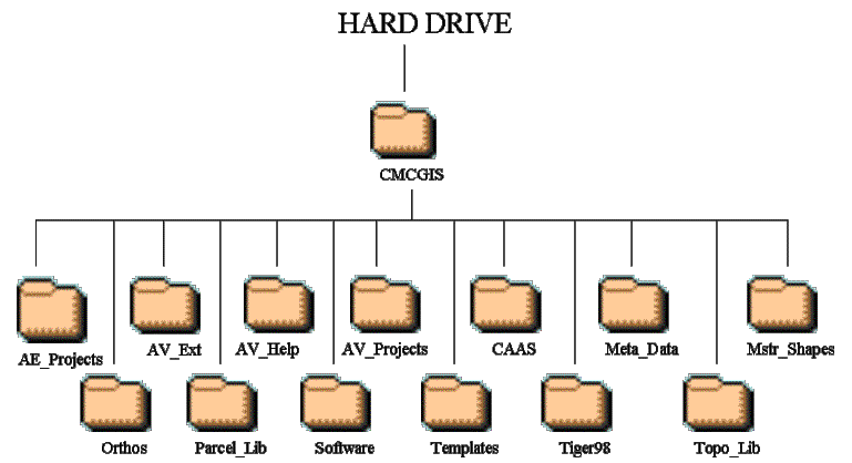
1. Common Directory Structure:
Directory Explanations:
1) CMCGIS – The top of the directory tree under which a useful breakdown of folders allows organization of distributed information. A top folder under which organizational folders exist allows easy updating of data and applications. Also this allows the establishment of a ‘master’ system environment variable used in many different ways (Discussed later).
2) AE_Projects – Default ArcExplorer Projects. Default displays of data to jump start users in what GIS is and what answers can be derived by using GIS. This allows the viewing of ‘Enterprise’ GIS Info without having to have invested in ArcView, which is a $1,000 software product. With the location of data now known by the common directory structure it is possible to set the ArcExplorer projects data paths relative to the position of the ArcExplorer default project. How to do this is explained in the ArcExplorer documentation.
3) AV_Ext – ArcView Extension Directory. This directory is for Extensions written by the GIS Center or found by the GIS Center or others on the www.Esri.com/arcscripts or other web sights that have been shared for the use of the GIS community (It is worth noting at this point that the CMCGIS Center has taken full advantage of this great GIS Community out there that shares extensions, avenue scripts, techniques and solutions to problems. Participants in this GIS Community are allowing GIS technology to be the success that it is). This directory is also linked with the ArcView ‘userext’ environment variable (Discussed later).
4)
AV_Help –
 A directory containing MS Windows Help files explaining the concept of the
‘Enterprise’ GIS center and the base data sets.
The MS Windows Help Compiler can be found free off of the MS web site.
Other locations on the web show some great examples on how to use this MS
Windows Help Compiler. This help
compiler has been replaced with the MS HTML Help Compiler mentioned later.
These help files are accessed from the base ‘CMCGIS’ Extension
(Discussed later).
A directory containing MS Windows Help files explaining the concept of the
‘Enterprise’ GIS center and the base data sets.
The MS Windows Help Compiler can be found free off of the MS web site.
Other locations on the web show some great examples on how to use this MS
Windows Help Compiler. This help
compiler has been replaced with the MS HTML Help Compiler mentioned later.
These help files are accessed from the base ‘CMCGIS’ Extension
(Discussed later).
5) AV_Projects - This directory contains default ArcView Projects that serve the general ‘Enterprise’. Examples: Parcel_Checker.apr – Links the parcels view with the parcels table allowing interactive record/feature selection. 1-100TaxMapPlotter.apr - Allows exact replication of 1:100 Tax Maps with any data you wish to add to it, plus multiple map plotting. And others…
6) CAAS – This is a copy of the Counties CAMA that is updated from the Assessor of Properties office to the ‘Enterprise’ monthly (~400 MB in size). The States FOXPRO application is distributed with this data. The CAMA is linked with two of the ArcView Default projects in the AV_Projects directory.
7)
Meta-Data –
 This directory houses a MS HTML Help file that contains meta-data for all data
distributed by the ‘Enterprise’ GIS. Meta-Data
is compiled and updated using ArcGIS ArcCatalog and is in the Arc/Info XML
format. A master listing in HTML Web Page format is provided showing
a list of all data sets with one-line descriptions. The XML files are modified slightly to allow sharing within
the ArcView environment (Discussed later).
The MS HTML Compiler is available free from the MS website.
This directory houses a MS HTML Help file that contains meta-data for all data
distributed by the ‘Enterprise’ GIS. Meta-Data
is compiled and updated using ArcGIS ArcCatalog and is in the Arc/Info XML
format. A master listing in HTML Web Page format is provided showing
a list of all data sets with one-line descriptions. The XML files are modified slightly to allow sharing within
the ArcView environment (Discussed later).
The MS HTML Compiler is available free from the MS website.
8) Mstr_Shapes - ~70 shapefiles below this directory. The location to get the ‘Enterprise’ (shared) shapefiles.
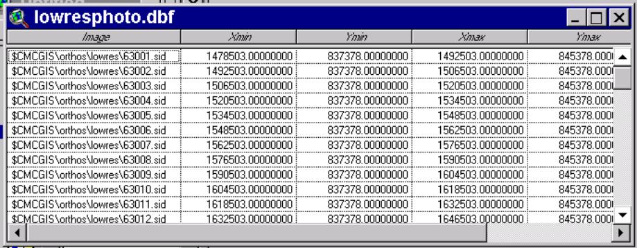
9) Orthos – The low resolution and high-resolution Mr. Sid images of the county along with the Image Catalogs. The Mr. Sid format files were compressed into individual 2.8 MB files. There are 161 low-resolution images and ~400 high-resolution images. This was done to allow easy extraction back to tiffs using the Free MrSidViewer software off of the Lizard Tech website. This allows other software (AutoCAD R14) to use these images. The Image Catalogs also use the %CMCGIS% environment variable to point to image files.
10) Parcel_lib – This directory houses the Assessor of Properties parcel ownership database (~54,000 parcels). This is an Arc/Info Librarian structure (~400 MB in size). Again this is accessed in ArcView by setting the proper environment variables, sharing the proper 'Database' directory and 'Table' Directory along with slight modifications to the Database and Tables Directories of the Arc/Info Librarian Structure (Discussed later).
11) Software – This directory is for sharing useful applications. This includes: WinZip, Shape_Check, APR_Tool, AV31patch.exe, aeclient.exe, MrSidViewer_setup.exe. This directory is starting to house MapObjects applications being distributed by the GIS Center. I.E. Fire_Dept_Viewer, Police_COMSTAT_Viewer, Bldng&Codes_Viewer, Generic_Viewer, GW&S_Viewer…
12) Templates – This Directory houses MS Word Macro’d documents along with write able text documents used in mail merges.
13) Tiger98 – This is 1990, update 1998 census information for Montgomery County TN. Will be updated to census 2000.
14) Topo_lib – This is an Arc/Info Library constructed by the GIS Center. This library contains a 2 ft. contour layer for urban areas and a 5 ft. contour layer covering the whole county. Also Slope polygons compiled by the GIS Center covering the county. This library can be accessed through ArcView using the proper environment variable and altered Database and Tables Info directories (Discussed later).
2. Using System Environment Variables to support, Image Catalogs, Arc/Info Library Structure and to allow the creation of user-friendly applications for the ‘Enterprise’.
A System Environment Variable – ALGEBRA FOR COMPUTERS
X = 1 Y = X + 2 Y = 3
X=”C:\CMCGIS” Y = %X% + “\MSTR_SHAPES\” Y=C:\CMCGIS\MSTR_SHAPES\
In WIN98 YOU SET THESE IN YOUR AUTOEXEC.BAT
IN WINNT YOU GOTO START>SETTINGS>CONTROL-PANEL>SYSTEM> ENVIRONMENT TAB (Go to Environment Variables)
IN WIN2000 YOU GOTO START>SETTINGS>CONTROL-PANEL>SYSTEM>ADVANCED TAB>Environment Button
The Environment variables used by the CMCGIS Center: These environment variables must be set on ALL client computers participating in the ‘Enterprise’.
A Win98 Example of CMCGIS Center Environment Variables in the AutoExec.Bat
SET CMCGIS=”C:\CMCGIS”
SET ARCHOME=%CMCGIS%+”\PARCEL_LIB”
SET MONTGOMERY=%CMCGIS%+”\PARCEL_LIB”
SET USEREXT=%CMCGIS%+”\AV_EXT”
CMCGIS – Used in all CMCGIS Center applications to point to ‘Enterprise’ directory structure (shapefiles, libraries, ortho-photos, meta-data). This is needed to coordinate which drive and path the information is stored. The drive letter and directory path to data could potentially be different on each computer participating in the Enterprise. Setting this environment variable allows us to write applications that use this environment variable instead of absolute paths to information. We can then write user-friendly apps while knowing where to get the data that drives the applications.
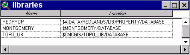
ARCHOME – This variable is used in Arc/Info. It is important to ArcView and us because it identifies the location of the ‘Tables’ directory which contains the ‘libraries’ info file. The ‘libraries’ INFO file allows ArcView to get a list and base location of the Arc/Info libraries on the system. In our case this is the Parcel Library and the Topo Library.
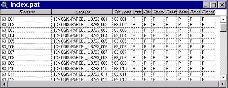
MONTGOMERY – the Arc/Info library ‘DataBase’ Directory uses this environment variable. This directory is pointed to by the ‘Location’ field of the ‘libraries’ INFO file. The 'index.pat' INFO file within the DATABASE directory points to the actual Arc/Info Workspaces where the data coverage’s are stored (OBSOLETE).
USEREXT – This is an environment variable defined by ArcView that allows ArcView to look into a different directory to recognize ArcView Extensions. The GIS Center writes ArcView extensions that rely on ‘Enterprise’ data being in locations defined by the %ARCHOME% and the %CMCGIS% environment variables. We point this environment variable to %USEREXT% = %CMCGIS%/av_ext.
3. Setting up the Arc/Info Libraries.
The two Arc/Info Libraries, Parcel_lib and Topo_lib: why are they necessary? The size and amount of related information trying to be shared. The Topo_lib contains 2 ft contours for urban areas, 5 ft contours for the Whole County and polygons showing areas of similar slope. How do you store 5ft contours for the whole county in an easily accessible manner. One shapefile would be huge and unwieldy. A mechanism to store such large data sets is the Arc/Info Library structure. The Parcel_lib consists of ~54,000 parcels with all the other information you see on a tax map. Annotation of Parcel Numbers, Lot Numbers, Subdivision Names, markers showing subdivision boundaries, special symbols traditionally used on tax maps. This also is a huge amount of data that is related to each other. Again the Arc/Info Library is a structure mechanism to handle this database. How does the Arc/Info Library work and how do we modify it to work with ArcView and the CMCGIS Center data structure?
The Arc/Info Library is a series of Arc/Info Workspaces organized to hold Arc/Info coverages that are spatially and informationaly related. This structure begins with the ‘Tables’ directory, an INFO directory with a ‘libraries’ file that lists existing Arc/Info Libraries on a system. Since Arc/Info created this Library the ‘Tables’ Directory is found in the installation path of Arc/Info (e:\arcexe80\tables). We can copy this ‘Tables’ directory to other computers that do not have Arc/Info but do have ArcView. Then set the ‘ARCHOME’ environment variable to point to the directory so ArcView can recognize the ‘Tables’ directory. Note below the ‘Name’ field naming Libraries and then the Location of the library. In this ‘location’ field we can use the Environment Variables that we have defined. Thus making the drive and directory path of data dependent on the Environment Variables that we have set on each computer.
The ‘Location’ field, above points to where we find another INFO file, ‘index.pat’(illustrated below). This INFO file points to where the Arc/Info Workspaces are located. They contain the actual data coverages. Also note that we have again used our Environment Variables to point to where the data is located on each computer or computer network.
So by setting environment variables on our client computers and using these environment variables in our Arc/Info Library definition files we can ensure that all computers, no matter what their drive and directory make up, can see the parcel library and the Topo library.
4. Compressing the Imagery.
There was ~20 GB of aerial imagery in tiff format. The stumbling block was how to distribute 20 GB of data when most of the computers in the city and county did not have 20 GB of storage. Also, the number of CD’s required to distribute 20 GB of data was prohibitive also. We used Lizard Tech’s Mr. Sid compression software to compress this down to ~1.5 GB. We did not mosaic the tiffs into large Mr. Sid images. We compressed each 28 MB tiff into one 2.8 MB Mr. Sid image. Then we constructed Image Catalogs of the high and low-resolution imagery. We did this to allow our Non-Esri software users (CAD’s) to be able to utilize the compressed imagery. This worked by the GIS Center also distributing the free Mr.Sid_Viewer from Lizard Tech. This allows Mr. Sid files to be uncompressed into tiffs. So a CAD user could import the Map Tile Grid in Shapefile or coverage format and then take the uncompressed tiff and fit it to geo-rectified map space. Thus allowing the GIS Center to serve all our users. Some of our users who plot a lot of aerial photos have requested the uncompressed tiff image libraries now that computer storage is cheaper and plot time is faster with uncompressed images.
5. Setting up Image Catalogs.
An ArcView Extension/Project was downloaded off of the ArcScripts website that created Image Catalogs. This Extension/Project was modified to allow the SID format to work in the Image Catalog construction process. We also use our %CMCGIS% environment variable in the Image Catalog .DBF file to allow the catalog to work on any computer as long as the environment variable has been initialized.
6. Setting Up Meta-Data XML files using ArcCatalog.
We reviewed a couple of meta-data creation options. A couple of ArcView Extensions, one was from NOAA, that created meta-data was actually chosen and was started to be implemented when Arc/Info 8.0 was released. We then chose to use the ArcCatalog meta-data tools. This tool created XML files. The Extensible Markup Language (XML) works by having tags that are defined in a Style sheet. In our case a style sheet called ‘Esri.XSL’. It was discovered that if the ArcCatalog created XML was modified to look for the style sheet in a certain location, we could then distribute the XML meta-data files outside of the Arc/Info ArcCatalog environment.
If you create your meta-data using ArcCatalog then use a text editor (notepad, WordPad, Word) to edit the xml file (note edits in red below) and then copy the ‘Esri.XSL’ style sheet into the same directory as your meta-data xml file then you can open it with MS Internet Explorer 5.0 or greater.
<?xml version="1.0"?>
<!--<!DOCTYPE metadata SYSTEM "e:\arcexe80\metadata Stylesheets\Esri.xsl">-->
<metadata xml:lang="en"><Esri><MetaID>{4E6845B4-FA97-11D3-9DC5-00C04F37E7F2}</MetaID><CreaDate>20000315</CreaDate><CreaTime>11303300</CreaTime><SyncDate>20010212</SyncDate><SyncTime>10170800</SyncTime><…
7. Default ArcView Projects.
The idea here is to do needs assessment of your users and determine some common tools needed by a majority of users. Then create some read-only (set to read-only using file Attributes under file Properties) ArcView Projects. Then create ‘short cuts’ on your users desktops to allow easy opening of these ArcView Projects. The GIS Center has created ~ 4 of these ‘Default’ ArcView Projects. 2 of these ArcView Projects allow re-creation of Tax Maps in layouts that are sent to the plotter at proper scale. The beauty of these are that they allow almost an exact copy of a Tax Map with up-to-date information plus any other data sets the user wishes to add. They also allow the selection of multiple maps that are sent to the plotter in batch jobs. Another ArcView Project allows the user to identify parcels by owner, address or parcel number. There is also an overview view that shows location of parcel in the city and county. There is also a table that puts owners, addresses or parcel numbers in ascending order. The table is linked to the view so that if a table record is selected the feature is selected and zoomed to. This allows easy identification of parcels by the listed three parameters. An ArcView project is an ASCII text document. An ArcView document also recognizes system environment variables in UNIX format (this means instead of %CMCGIS% it is $CMCGIS). So in these ‘Default’ ArcView projects we can insert our $CMCGIS environment variable into the PATH parameter of the ArcView projects. We use the $CMCGIS (indicated in red below) instead of the absolute path that was originally written by ArcView.
EXCERPT FROM ARCVIEW PROJECT BELOW
)
(FN.185
Path: e:/cmcgis/Mstr_Shapes/strts_official.shp"
Path: "$CMCGIS/Mstr_Shapes/strts_official.shp"
)
(FTab.186
Name: "strts_official.dbf"
8. Writing ArcView extensions to serve the general user community and special customers.
The GIS Center has established the AV_EXT directory to put extensions that the GIS Center wishes to share. This AV_EXT directory is pointed by the %USEREXT% ArcView environment variable as stated earlier. The main extension that the CMCGIS Center has created is called ‘CMCGIS.EXT’. This extension is a suite of common tools used throughout the city and county departments. This extension contains ‘street find’, ‘parcel find’, ‘subdivision find’ tools among other generalized tools. This extension and other extensions also key off of the %CMCGIS% environment variable. ArcView extensions are also ASCII text files that can be edited with a text editor. Below is how these extension files are edited. Note the numerous environment variables used and recognized by ArcView.
EXCERPT FROM ARCVIEW EXTENSION
(Extension.1
Name: "CMCGIS"
Dependencies: "$AVBIN/avdlog.dll\n$AVEXT/dbaccess.avx\n$USEREXT/CMCGIS_OV.avx\n$USEREXT/dynamaoi.avx\n$AVEXT/mrsid.avx\n"
FirstRootClassName: "PMenu"
Roots: 2
9. Development of MapObjects to serve users who just VIEW data.
The GIS Center has made use of MapObjects to develop ‘Data Viewers’ for folks who just need to view GIS information but are not data editors or creators or need advanced GIS functionality. Though ArcExplorer is a FREE data viewer it was found to lack speed and customization that was required of of our users. The current users that we are serving with MapObject Viewers are:
a. Fire Department Fire Dispatch Center
b. Police Department COMSTAT Viewer for Head Quarters.
c. Sheriff Department Patrol Car MDTs.
d. Building and Codes Department Permit and Citation Tracking.
10. The use of ArcIMS to serve the public 24/7.
Using ArcIMS will, hopefully, give some relief to city/county departments as far as information inquiry from the public. A series of MapServices are being served to the general public to distribute city/county information. The ArcIMS has been tailored by student programmers to serve information in a way specific to GIS Center and city/county standards. The development of city/county departments serving information in an IMS fashion is still in its fledgling development.
11. Visual Basic programs and ArcView Scripts for In-House processing of data for dissemination.
The GIS Center has developed two (2) main applications for the once-a-month data/application delivery. The first is an ArcView Project that exports the parcel Arc/Info Library into a shapefile format and merges this shapefile with the CAMA (~150 attributes about each parcel in a MS FOXPRO database). This ArcView project creates 4 shapefiles. One is just parcels with topologic information (area, acreage, perimeter, parcel number). Two is a short list of parcels with attributes (addressing information, with owners and subdivision plus other location information. Three is the long list of attributes per parcel witch is about 100 attributes per parcel. Four is a parcel centroid shapefile with the addressing information. The other main application is a Visual Basic Application. This application reads the ‘master’ data structure. This structure is the one mentioned above that is on all client computers or servers. But this one is the master copy. The Visual Basic application reads this master structure and checks modified dates on files. The application creates another CMCGIS directory in a location specified by the operator. If a file has been modified in the previous month then the directory and all associated files is automatically copied to this location. So any data or application changes made to the master directory structure is copied to a new location. This directory structure of changed information is then cut to a CD. The CD of information modifications is what is disseminated once a month to departments participating in the ‘Enterprise’.
The In-House processing applications are there so the work by GIS Center staff to update city/county departments is kept to a minimum. This frees up time for application development or development of new data sets for the ‘Enterprise’.
Summation:
The technical and administrative techniques mentioned above allows the CMCGIS Center to deliver updated data and updated applications on a once-a-month basis to ~18 city/county departments. The use of a common directory structures with logical sub-directories combined with system environment variables allow dissemination of information to stand alone computers and networks alike. The method preferred by me is riding my bicycle around to the different departments. While the data/applications are downloaded/updated I can talk to the users and help with current problems or note existing problems with data/applications. This face time often spurns new developments in useful tools and/or data that better serves the ‘Enterprise’.
Robert Brundage, GIS Manager
Clarksville/Montgomery County GIS Center
Austin Peay State Univeristy
P.O. Box 8373
Clarksville, TN 37043
PH: 931.221.7590
FAX: 931.221.7476
email: brundager@apsu.edu