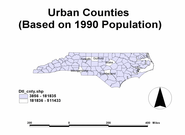
Figure 1: Urban Counties (1990 Population)
According to the media, drugs are spreading from urban environments to rural areas. But are they? The current research examines this issue by mapping the location of drug arrests from 1986 through 1998. Using ArcView, data is analyzed to discover if graphic representations of officially recorded incidents of various drug violations actually show a pattern of drug arrests spreading from urban settings into rural locales. Once the common sense belief is statically plotted, Ulead animation is applied, powerfully making the visual argument that this urban to rural drug flow is occurring.
Increasingly both academicians interested in criminology and criminal justice practitioners are using computerized mapping programs to plot shifts in criminal activity within specified jurisdictions. Such practices have yielded positive results, as evidenced by "hot spot" police targeting and more effective and responsive zone apportionment. The many successful and publicized uses of mapping programs on the micro-level are impressive, but sometimes overshadow the potential extant in macro-level, multi-jurisdictional data.
This exploratory study's purpose is to take a common belief asserted by the media and see if it can be quantified graphically both in static and animated mapping formats. According to media statements, drugs are spreading from urban environments to rural areas. There is no argument that this should seem to be the logical progression of drug activity. What remains to be seen is if the mapping of more than a decade of drug offense data reflects the flow of trafficking that is expected.
North Carolina was chosen as the subject for this research. The state is rich in contrasting environments. Like California, it can boast of mountains, plains, and beaches within a few hours drive of each other. Also like California, North Carolina has counties that are clearly highly populated urban centers, surrounded by more sparsely settled rural/agricultural counties. Of the 100 counties making up the state, 5 counties were designated as urban counties based on 1990 census data: Cumberland, Forsyth, Guildford, Mecklenburg, and Wake. The only two urban counties abutting one another are Forsyth and Guildford.
Figure 1: Urban Counties (1990 Population)
As can be seen in Figure 1, produced by using ArcView, the urban counties are primarily located in the plain or piedmont portion of the state. The least populous and most poverty-ridden counties are some of those located in the mountains to the west and coastal regions to the east. This geographic distribution of urban and rural counties lends itself well to discovering if drug trafficking data mapped out over time yields the assumed pattern.
Official drug arrest data for this longitudinal work was obtained from the Uniform Crime Report (UCR). Like all official sources of information, the data used here shares the problem of not being truly representative of actual drug sales or use. Only incidences where arrests are made appear in the various counties' annual reports. However, such information can still indicate where a county previously making few drug arrests experiences a significant increase. By comparing annual reports from the 12 years starting in 1986 and ending with 1998 for all the counties of North Carolina, results are more likely to uncover true trends, pulling outliers and flukes in data into proper perspective.
Employing a color coded legend, arrest information is mapped per county per year, with the darkest green indicating areas with the lowest number of drug arrests (0 - 27 annually) shifting through the spectrum to brightest red for counties with the highest enforcement results (1575 - 6446 annually). Figure 2, the static map for 1986, shows 3 of North Carolina's counties with major urban communities glowing in the most intense red, as was expected.
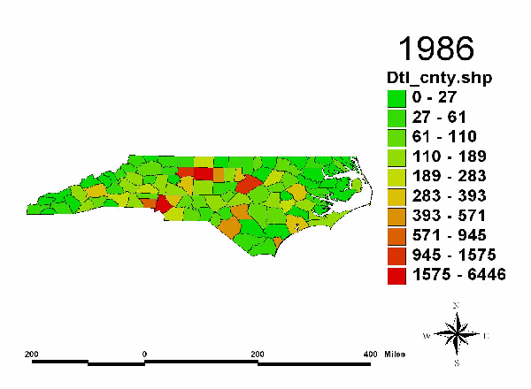
Figure 2: Number of Drug Arrests (1986)
Mecklenburg, Guildford, and Wake counties are closely followed in numbers of arrests by Forsyth (945 - 1575 annually) and Cumberland (393 - 571 annually) which are shown in lighter red or orange, respectively. Even beginning with this static ArcView representation of the 1986 drug arrests in the state, viewers begin to pick out a pattern. With 4 exceptions, the regional runners up in terms of arrest numbers are all located in counties with boundaries touching or surrounding their more urban counterparts. On closer examination, these 4 unusual regions, Buncombe, New Hanover, Onslow, and Pitt counties which seemingly show anomalously high drug arrest rates all share common characteristics. They each host either the secondary population centers for North Carolina and/or traditional drug entrepreneur target populations such as universities or military bases. For example, the westernmost anomalous county is Buncombe. This county encompasses the city of Asheville, the largest regional center in the mountains. The environs of this county also include a college and 2 important interstates facilitating transportation. Pitt county harbors Greenville and a university. A U.S. Marine base is placed in Jackson in Onslow county. The remaining high drug arrest pattern distinction goes to New Hanover, the location of Wilmington and another university.
As interesting as the static ArcView annual map plots are, their real ability to demonstrate the changes in drug movement over time is blunted. The necessity of the reader having to look from map to map, remembering and making comparisons can prove to be cumbersome and taxing. The impact of the data is often lost. By adding Ulead animation, the problem disappears. Watching the animated Figure 3 displaying the changes in drug arrest patterns from year to year alerts the viewer to the spread of drugs from the urban areas to the rural locales in a compelling and impressive fashion. In animation, the fluid movement of drug arrests from the urban arenas to the rural settings becomes indisputably observable.

Figure 3: Animated Drug Arrests for 12 years
The power of combined ArcView plots and Ulead animation can be harnessed to serve a number of purposes. For those in academia, the clear illustration of the migration of a crime over time drives the point home to students and colleagues efficiently. For practitioners in criminal justice charged with drug enforcement responsibilities, these tools can facilitate planning for future statewide or multijurisdictional task force drug strategies as well as showcasing the impact of on-going police efforts to combat trafficking. For smaller rural agencies facing budget battles over the need for increased monies to fight a burgeoning drug problem, this form of presentation becomes a powerful weapon in defending the argument that even "out here in the sticks" the issue is real and immediate. The visible wave of change in drug arrests bearing down on their jurisdiction makes the statement eloquently in a way numbers and graphs cannot.
One question has been answered here. Yes, the ripple out effect of drug movement from urban centers to rural areas can be graphically plotted and animated in a way that supports this common sense belief. Something else also needs to be noted here: there is a startling difference in presentation of longitudinal research when variables can be displayed in a format allowing for plotting and animating. The boost in impact for demonstrating the resulting data is incontrovertible. What still remains to be discovered in this current case, however, is how much of the resultant effect is real versus how much is just apparent movement. At this point, the conclusion must remain open-ended.
As is the case with most exploratory studies, further research needs to be done. Some of the shift in the spreading drug arrests is probably accountable for by variation in county populations, population growth, and population movement within North Carolina. Part of the shift in arrest numbers is also indicative of the spread of greater recognition and enforcement of drug violations. Even with the limitations of official data, this is still one of the best indices we possess to track drug movement. Cynics and paranoiacs aside, the police are unlikely to execute drug enforcement where drugs are not present. Another factor to be considered when looking into the change in patterns of drug arrests is the addition of major and medium traffic corridors to more rural regions over time. This could also contribute to the expansion of drug trade and subsequent drug arrests. Continuing research by these authors is focusing on those additional considerations.
Esri (1996). ArcView GIS (Version 3.1). Redland, CA: Environmental Systems Research Institute, Inc.
Ulead Systems (2000). GIF Animator (Version 4.0). Torrance, CA: Ulead Systems, Inc.
U.S. Dept. of Justice, Federal Bureau of Investigation. UNIFORM CRIME REPORTS: COUNTY LEVEL ARREST AND OFFENSE DATA, 1986 [Computer file]. 2nd ICPSR ed. Ann Arbor, MI: Inter-university Consortium for Political and Social Research [producer and distributor], 1986, 1988-1998.
|
Kenneth A. Clontz, Ph.D.
|
J. Gayle Mericle Associate Professor Western Illinois University Department of Law Enforcement and Justice Administration Stipes Hall 403 1 University Circle Macomb, IL 61455-1390 Office Phone: 309-298-1928 E-Mail: Gayle_Mericle@ccmail.wiu.edu |