Elzbieta Covington, Buz Kloot, and Hemanth K Reddy Taduri
Abstract
The Earth Sciences and Resources Institute at the University of South Carolina (Esri-USC), in conjunction with the Natural Resources Conservation Service in South Carolina (NRCS-SC), began development of a GIS-based Decision Support System for animal feeding operations (AFO) in 1998, for the Pee Dee region of South Carolina. The Decision Support System (DSS) is used to site proposed AFOĺs according to regulatory, environmental and microeconomic data. This paper is an update on the field testing and further integration of the DSS with the NRCS Customer Services toolkit software, digitization effort, and Web-based application with ArcIMS.
Introduction
The program of applied research between the University of South Carolinaĺs Earth Sciences and Resources Institute (Esri-USC) and the U.S. Department of Agricultureĺs Natural Resources Conservation Service in South Carolina (NRCS-SC) is now in its third successful year. The intention was that Esri-USC would assist the NRCS in the development and implementation of a GIS-based Decision Support System (DSS) to promote environmentally sound planning of conservation systems, especially those concerning siting of Animal Feeding Operations (AFOs) and the utilization of animal manure. By the end of 1999, the first version of the Decision Support System had been developed and tested. Later, the program broadened to other USDA program areas and another GIS customized application was developed to aid the Conservation Reserve Program (CRP).
The U.S. Department of Agriculture (USDA) has been involved in a modernization effort since 1995. The modernization consists of common local area network, a common computing environment, data management processes, and Business Process Reengineering (BPR). The research and development at Esri-USC has been conducted in a manner consistent with the USDAĺs technology modernization initiative through the BPR program. ArcView and other software platforms anticipated for the USDAĺs common computing environment have been used throughout Esri-USCĺs software development.
Animal Feeding Operations Background
Animal Feeding Operations, if not managed properly, pose a great threat to the quality of water. Initial regulatory focus to control livestock effects on water quality was through the Clean Water Act (CWA) of 1972. The main tool of control over AFOs was through the National Point Source Discharges Elimination System (NPDES) permit system where large AFOs would be treated as point sources and appropriately permitted. National attention was focused on AFOs when, in March 9, 1999, the U.S. Department of Agriculture / U.S. Environmental Protection Agency Unified National Strategy for Animal Feeding Operations (USDA-EPA, 1999) was developed. The primary goal of the strategy is to minimize water quality and public health impacts from AFOs using the existing legal and regulatory framework. Under the strategy, producers will need to develop site-specific Comprehensive Nutrient Management Plans (CNMPĺs) as part of an NPDES permit application.
The Decision Support System Development
The DSS for planning AFO's address many of the CNMP components required by the USDA and EPA identified in the Unified National Strategy for AFOs. The first version of DSS for AFO's planning, developed in 1999 and updated in 2000, utilized the functionality of ArcView Spatial Analyst Extension and generated grids for the selection of AFO locations and waste utilization areas, calculated net manure hauling costs, and scored fields for land application (Covington, et al., 2000). The application went beyond compliance to address a number of spatial environmental criteria including: proximity to wetlands, soils erodibility and leachibility, and watershed contamination by nutrients and pathogens. The DSS was field tested in the Marlboro County, SC NRCS field office in the latter half of the year. Feedback from the local NRCS District Conservationists (DCĺs) indicated that a simpler application was required to address specific compliance needs required for permitting and the development of a Waste Management Plan (analogous to CNMP). Help was needed especially in the calculation of field areas, buffer areas, the resultant land-application areas, and manure application calculations. The DSS was modified and a simple wizard, called AFOWizard, was developed. AFOWizard is a small subset of the first version of a DSS.
AFOWizard Description
AFOWizard was build as an ArcView extension with Visual Basic and Avenue scripting languages. Software specifications included the following:
While in the process of development, the Esri-USC design team adopted the NRCS Toolkit philosophy to supply the decision-maker with spatial tools that enable them to perform the job more effectively and quickly. Design of the new DSS, called the AFOWizard, was thus based primarily on ease of use. The AFOWizard uses Avenue scripting and Microsoft Visual Basic programming to link ArcView spatial data with manure land applications calculations in an Excel spreadsheet developed by NRCS engineers.
The general process is as follows:
Step 1: User gathers or develops (usually from topographical images and aerial photography) all spatial data required to site operations and calculate land application areas. In the case of South Carolina regulations, data required include farm fields, property lines, potable wells, ditches, streams, and waters of the State.
Step 2: User enters livestock operation design data including animal, live weight, quantity of manure, nutrient content of manure, crop rotation (typically a selection of about 10 crops suited to a district) and crop nutrient requirements into the Excel workbook.
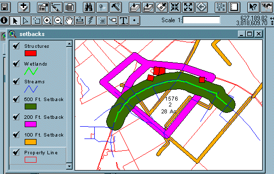
Step 3: User selects Toolkit buffer tool to create setback areas germane to the type of operation (size, type of animal, feature) and local features (ditches, streams, residences, wetlands) and selects which fields are planned for land application (Figure 1).
Figure 1: Land Application Buffers Created According to Regulations and Site-Specific Features
Step 4: User launches AFOWizard from ArcView within a Toolkit Customer project window (Figure 2) that ensures the spatial and tabular data are available. AFOWizard then calculates areas of selected fields and the overlapping areas of selected buffers (user specified) and writes tract number, field number, field area and setback area to Excel. Excel in turn calculates manure land application requirements based on user specified inputs.
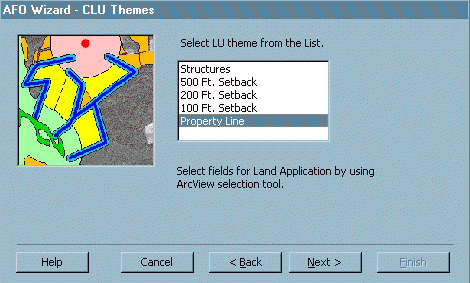
Figure 2: One of several AFOWizard prompts
Step 5: The user is then able to access Excel and change parameters such as crop, nutrient quantity and content, among others, and review sensitivity of land application scenarios with the given data (Figure 3).
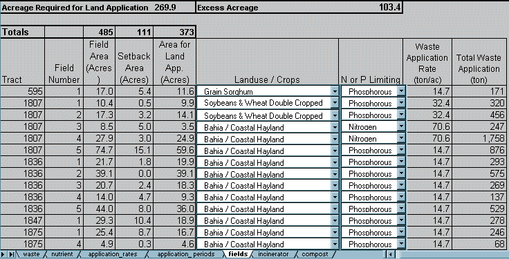
Figure 3: Excel worksheet displaying manure land application data.
Implementation of the AFOWizard in NRCS Field Offices
Since the development of the AFOWizard prototype in March of 2001, the application has been used in seven different counties in South Carolina to develop Waste Management Plans (WMPĺs) for dairy, poultry and swine operations. The application was also used for the development of four poultry WMP extensions in Wayne County, Mississippi, and it is being evaluated by the NRCS state office in North Dakota.
Esri-USCĺs work has shown that in the development of Waste Management Plans for South Carolina Department of Health and Environmental Control (SCDHEC), the text-based paradigm has been successfully replaced with the GIS-based paradigm. Preliminary results show the following:

Figure 4: Time savings in WMP Development.
The Conservation Reserve Program
The Conservation Reserve Program (CRP) improves environmental quality. The CRP was enacted through Congress in 1985 to reduce erosion, stabilize land prices and reduce chronic excess production (Zinn, 2000) and was implemented through the Commodity Credit Corporation (CCC). CRP is a voluntary program, aimed at croplands that are highly erodible or ecologically sensitive, encouraging farmers to enroll these lands by implementing measures to improve the long term soil, water, and wildlife properties of the land. Incentives are given through annual rental payments, cost-share for establishing certain practices, and incentive payments for certain activities. Contract duration is typically between 10 and 15 years. Participants receive payments through the Farm Service Agency (FSA) while technical assistance in determining eligibility of lands is supplied by the Natural Resources Conservation Service.
Initially, the only criterion for eligibility was reduction of soil erosion. Since 1990, however, a change in the emphasis of CRP to address various environmental benefits is apparent. By the 10th signup in March 1991, the competitiveness in the bid process for CRP was for the first time determined by the formula called the Environmental Benefits Index (EBI). The EBI is a result of the Environmental Targeting Approach, which refers to the practice of directing scarce resources to lands where the greatest benefit is generated per given expenditure.
The EBI national ranking factors of the 20th signup of 2000 show that most of EBI factors can be spatially represented (Table1) (USDA, 2000).
Table 1: Environmental Benefits Index (EBI) of the 20th CRP signup.
|
National Ranking Factor |
Subfactor |
Spatial? |
|
N1 Wildlife Habitat Cover Benefits |
a. Cover Factor |
N |
|
b. Threatened and Endangered Species |
Y |
|
|
c. Proximity to Water |
Y |
|
|
d. Adjacent to Protected Areas |
Y |
|
|
e. Wildlife Enhancement |
N |
|
|
f. Percent Upland Acres to Wetland Acres |
Y |
|
|
N2 Water Quality Benefits |
a. Water Quality Priority Areas |
Y |
|
b. Ground Water Quality |
Y |
|
|
c. Surface Water Quality Benefits |
Y |
|
|
d. Cropped Wetlands Percentage |
Y |
|
|
N3 On Farm Benefits of Reduced Erosion |
Weighted Erosion Index (EI) for Wind or Water, whichever is larger . |
Y |
|
N4 Enduring Benefits |
a. Practice |
N |
|
b. Practice/Condition |
N |
|
|
N5 Air Quality Benefits |
N |
|
|
N6 Conservation Priority Area |
Y |
Feedback from NRCS-SC staff indicated a need for a geospatial scoring tool that addresses a CRP program. So far the process of scoring has been done manually and, depending on the number of proposed fields for CRP signup, it can take a considerable amount of time. Similar to the AFOWizard, a wizard approach was taken, and a simple application called CRPWizard was developed.
CRPWizard Description
The design of a CRP field scoring tool focused on ease of use and spatial data availability. Similar to AFOWizard, the CRPWizard was build as an ArcView extension with Visual Basic and Avenue scripting languages. The CRPWizard works with ArcView Spatial Analysis extension. The CRPWizard is now a working prototype and has been used to score farm field data in Marlboro County, South Carolina.
Data
Vector and DEM data were obtained for all of the spatially amenable subfactors, represented in Table 1. Vector data consists of hydrography, soils, wetlands, conservation priority, and water quality priority boundaries. Fifty meter grids were created from the vector data based on the scoring points awarded. The following are a few examples of the grid data layers created for CRP project.
N1 Subfactor (c) identifies proximity to water. Zero points are assigned if distance to water is greater then 1 mile, 5 points are assigned if distance to water is from 1/4 to 1 mile, and 10 points are assigned if distance is less than 1/4 mile.
N2 Subfactor (a) identifies water quality priority areas determined by factors related to groundwater recharge, Coastal Zone Act, coastal nonpoint pollution control programs and 303(d) listed watersheds identified by rules in the Clean Water Act. Grid representation of the N2 Subfactor (a) is given a value of either 30 (if it is within a priority area) or 0 (if it falls outside a priority area).
N2 Subfactor (b) identifies groundwater quality. It is based on the leachibility index. The grid is created based on the leachibility index from SSURGO database and is assigned from 0 to 20 points.
In the same way, all CRP subfactors in Table 1 with spatial properties can be rendered into grids and assigned CRP-specific scores.
Methodology
CRPWizard makes use of Map Algebra provided by the Spatial Analyst extension. All the grid layers are added together and the output from ArcView is written to Microsoft Excel.
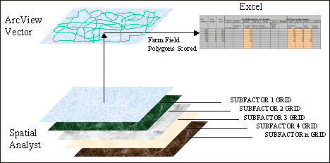
Figure 5: CRPWizard conceptual diagram showing interaction between GIS grids, vector layer and spreadsheet.
Conceptually, the CRPWizard function is simple (Figure 5):
An example of CRPWizard interface in shown in Figure 6.
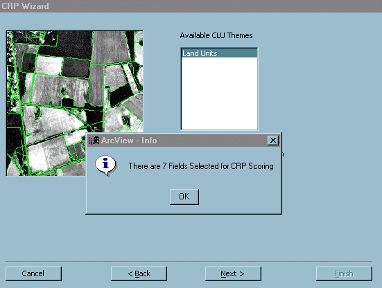
Figure 6: An example of CRPWizard interface.
Testing of the CRPWizard
Esri-USC intends to use CRPWizard to help score farm fields in those South Carolina (currently about 23) counties where spatial data (soils, hydrography, and digital elevation models) are available. The intended time of testing will most likely be from November 2001 through May 2002, coinciding with the CRP signup period. Expected benefits once again include time and quality improvements.
Related Issues
Digitizing of Farm Tracts and Fields
Vector data needed for use with AFOWizard and CRPWizard consists of a Land Units (LU) layer. The LU layer was digitized by Esri-USC from digital orthophoto quarter quads (DOQQ) provided by USDA-NRCS. The LUs are comprised of property parcels, or tracts, and the farm field(s) contained within each tract. Hard copy of the Farm Service Agency (FSA) aerial photo was used as a guide for digitizing. The farm field data have been digitized for three counties in South Carolina (Marlboro, Marion, and Dillon).
Web GIS
Esri-USC used ArcIMS to produce Web-based GIS application for Marion County, South Carolina. The application can be viewed at http://129.252.95.222/website/Marion. At this stage the user can display the data layers such as cities, animal feeding operations, wells, water quality stations, streams, DOQQs, etc. and view tabular data. All the standard ArcIMS tools are available to the user. By the end of 2001, ArcIMS application will be broadened to facilitate the increase in the geographic and application scope of the program.
Conclusions
The AFOWizard tool allows spatial siting of proposed livestock operations and automatically performs land application calculations based on field and setback area. It contains many of the elements of CNMPs that must be developed within the Unified National Strategy. Initial results show a large decrease in the time required to develop a Waste Management Plan for review with the South Carolina Department of Health and Environmental Control (SCDHEC). Noteworthy is that this new application is launched from inside the NRCS Toolkit software, making it the first application developed outside of the NRCS Information Technology Center to function in this environment. In the last year, development of GIS-based conservation systems at Esri-USC has become more sensitive to the needs of the NRCS field offices where field staff have a real need to provide customers with high quality conservation plans. Continued refinement and a Web-based interface, will further enhance the usability and power to the user.
Conservation Reserve Program (CRP) scoring tool (CRPWizard) was developed to help with the EBI scoring function. The application eliminates repetitive hand calculations, and allows faster, more accurate field scoring. Conservationist can make better quality decisions in less time and give farmers rapid feedback.
Acknowledgments
We are grateful to Senator Ernest F. Hollings for his leadership and to the South Carolina Congressional Delegation for their interest and support of this research.
References
Covington, E., Kloot, R.W. and Atkins, J.B. Tool for Animal Feeding Operations Siting. ArcUser Magazine. October-December 2000.
Eckblad, S.L., Strand, E.J., Carlson, J.C., 1998. Customer Services Toolkit: USDA Looks to the Future of desktop GIS in a Mobile Computing Environment. In Proc. Esri Users Conference July, 1998, San Diego, California.
U.S. Department of Agriculture ľU.S. Environmental Protection Agency. 1999. Unified National Strategy for Animal Feeding Operations.
U.S. Department of Agriculture. 2000. CRP Land Eligibility and EBI Scoring Worksheets.
Zinn, J., 1998. Animal Waste Management and the Environment: Background for Current Issues Environment. 98-451. National Council for Science and the Environment, Washington DC.
Author Information
Elzbieta Covington, GIS Specialist, Earth Sciences and Resources Institute, University of South Carolina, 901 Sumter St., Columbia, SC 29208, 803-777-0217, elzbieta@Esri.Esri.sc.edu
Buz Kloot, Research Assistant Professor, Earth Sciences and Resources Institute, University of South Carolina, 901 Sumter St., Columbia, SC 29208, 803-777-6484, rwkloot@Esri.Esri.sc.edu
Hemanth K Reddy Taduri, Graduate Research Assistant, Dept. of Computer Science & Engineering, University of South Carolina. 803-252-0558,