Feedback system to support interactive planning

 Kari Mikkonen


Abstract

The current ideology of interactive planning - in several countries also legislation – presumes that citizens are offered a chance and encouraged to participate in the planning process. In real life, the means that have been used so far are limited and very traditional.

Soil and Water Ltd has developed an ArcIMS based feed back system for interactive planning and used it successfully in several land use planning and EIA projects. The system supports easy composition and publishing of questions (besides internet also on mobile phones) and a real time analysis of the received feedback. The system enables also exact positioning of comments and spatial analysis of the feedback.


Interactive planning

Interactive planning is a strong trend in modern, democratic societies. Increasing concern of the state of the environment and sustainable development has lead to a tendency to favour communicative planning instead of previously popular instrumental and rational planning theories. Interactive planning means that citizens are given a chance to participate in planning, get acquainted with the planning situation, state opinions, comment preliminary plans, and give feedback. According to current planning philosophy encouraging citizen participation increases both satisfaction of the citizens and quality of the planned and built environment. In many countries this is also recognized in the legislation. In Finland the new Land Use and Building Act states clearly that in the beginning of the planning process the planners need to present a plan for participation. The Act on Environmental Impact Assessment Procedure sets similar requirements.

So far interaction has been implemented by arranging information meetings with an open invitation for people to attend. The planners have presented the situation and the preliminary plans, the audience has had a chance to ask questions and they have been handed a paper form where they can write their feedback. The meetings are a good opportunity to meet the planners face-to-face. However, there are several problems in getting useful feedback: it is not possible for all interested citizens to attend the meeting at a certain time. The citizens often need to take their time to form an opinion and think over what kind of feedback they would like to give. One of the biggest problems is that very few young people attend the information meetings.

Feedback system for land use planning

Soil and Water Ltd has developed tools and methods for an internet-based feedback system to support citizen participation in land use planning. The objective is to provide the citizens proper but easy-to-use tools for giving feedback, enable focusing the comments to a certain location and to provide the planners good tools for analyzing the feedback. We see several benefits in this kind of a system. It provides the citizens a new channel for getting up-to-date information about planning (objectives and situation) and entering their opinions and comments. It will not replace the face-to-face meetings but it will complement them by giving a chance to get acquainted with the material before the meeting and enabling commenting afterwards. The citizens can take their time and give the feedback whenever convenient. We also expect this to increase participation of the youth.

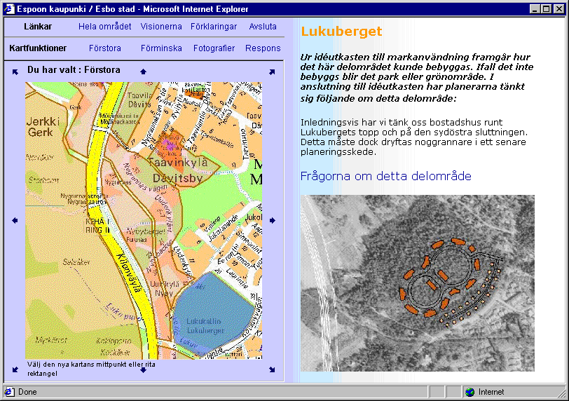
The system consists of an Internet Map Server and a form based feedback system. Internet Map Server is used for presenting the planning area and preliminary visions of land use. The material (planning area, sub-areas, preliminary visions) is presented as intelligent vector data on top of a background map. The background map is scale dependent: in small scale we have used base maps or guide maps and in large-scale municipal base maps or orthophotos. We have attached digital photos and text documents either to objects or separate hot link points. They can give a lot of additional information about the characteristics of the area. In the case of a local master plan for the Suurpelto area in Espoo, the planning area was divided into twelve sub areas. Main characteristics of each sub area were described by an HTML document including both text and images.

Picture 1: Text and image information attached to the highlighted sub area of Lukuberget includes description of the sub area, aerial photograph and a sketch of preliminary land use vision. (Guide map and aerial photo are provided by city of Espoo)

The form based feedback system is used for presenting questionnaires and collecting data and feedback from the citizens. Soil and Water Ltd works in close cooperation with Codeonline Ltd who is specialized in wireless solutions and feedback systems. Codeonline Ltd has developed a software package called SurveyCode whose main use has been in market survey and analysis. The system includes SurveyEditor for easy design of the questionnaire forms. The questionnaires are uploaded on the server where they can be distributed on various platforms: in addition to HTML web pages the questionnaires can be run on several mobile phone platforms (WAP, HDML, i-Mode). The answers are stored in a database on the server. Every time a new answer is received the system runs analysis of the database. For “select best alternative”, “select all that apply” and “enter a number” type of questions the system maintains statistics and charts that describe distribution of the answers. For free text comments the only statistics that is produced in the number of replies.

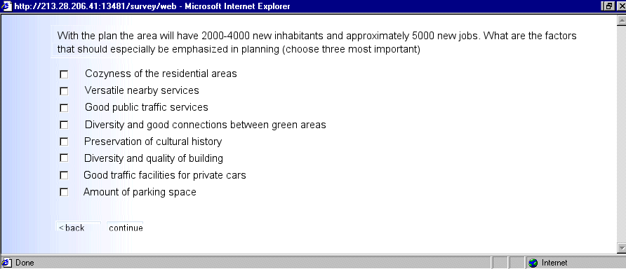
Picture 2: Example of a generic question concerning planning of the area

The feedback system is used in two ways. It is used for collecting general information about the concerned citizen: his contact information (if he wishes to enter it), his background and opinions concerning land use planning, and his expectations concerning the particular case of planning that he is commenting. Those who leave their contact information will be sent (if they wish) information of the planning during the whole planning process. The system is also used in collecting comments that concern a particular sub-area or geographic object indicated on the map. In case of indicated areas each area will have a specific questionnaire and the answers are stored in a separate table of that particular area.

The obvious benefits for planners are that:

Local Master Plan of Suurpelto

City of Espoo is about to start drafting a local master plan for the area of Suurpelto. Preliminary studies have been made and four alternative visions of land use have been prepared as the basis of discussion. We implemented a feed back service for Espoo for informing people about the planning process and encouraging them to participate in preparation of the Suurpelto general plan. Simultaneously with the service Espoo is having an environmental impact analysis (EIA) prepared about the alternative visions. The results of the feed back survey will be used in the EIA.

Suurpelto is a large unbuilt, mostly agricultural landscape in the middle of Espoo, the second largest city of Finland. It is surrounded by large residential centers and also high tech centers that are home for Helsinki University of Technology (in Otaniemi), Espoo-Vantaa Institute of Technology (in Leppävaara), State Research Center (Otaniemi-Tapiola), Nokia (Otaniemi) and several other significant IT enterprises. Many values meet and need to be compromised in the planning of Suurpelto. There are competing pressures to use the area effectively for residential building, build a high tech enterprise area, preserve the agricultural landscape and secure a green passage that connects the green areas on both sides of Suurpelto into one large continuous green zone.

Picture 3: Location and environment of the Suurpelto planning area. (Map is prepared by Espoo)

The feedback service is implemented using ArcIMS and SurveyCode platforms. The service runs partly on Soil and Water’s and partly on Codeonline’s server, it is entered from the city’s web pages. The service has two parts.

When the citizen enters the first section of the service he first registers and then goes through the first, questionnaire survey part of the service. The login dialog collects contact information. The mandatory fields are name and zip code which are used to identify the user in other parts of the survey or in later sessions. The citizens who enter their complete address (street address or email) will be sent information about the planning during the planning process. The questionnaire survey collects information about the citizen’s background (age, civil status, current form on living) and his opinions about the planning of Suurpelto. After answering all questions he will automatically enter the second part of the service.

The second part presents the Suurpelto area using Internet Map Server. Suurpelto is divided into twelve sub areas that are clearly indicated on the map. Besides maps there is a large collection of digital photos from all over the area attached to hot linked points. The map server is also used for presenting the preliminary visions of land use.

Picture 4: Presentation of one of the four different preliminary visions of land use. Red color indicates centrum or administrative services, orange businesses, purple public services & education and brown residential buildings. (Map and sketch are provided by Espoo)

When the user selects the feedback tool and clicks on one of the twelve areas he enters a short presentation of the area followed by questions concerning the selected area. In addition to having already commented Suurpelto planning in general, he can give feed back separately to any or all of the twelve sub areas.

The service runs both in Finnish and Swedish and it is available during summer 2001 from mid May till the end of August. The city arranged a press conference to open the service. It has gained good publicity in newspapers and local radio. Citizens and interest groups have given very positive feedback of the service.

Experiences

Our experiences from the projects where we have applied feedback systems to support interactive planning have taught us that:

We have also had some technical challenges that we have been expecting the time and Esri to solve. ArcIMS supports both HTML and Java based applications. We have only used the HTML platform. The Java version supports feature streaming which would enable graphical feedback, redlining and “stickers” (comments attached to a user defined point or area). However, the Java client requires installation of a browser plug-in which would scare and discourage most users of this kind of services.

Application areas

Besides land use planning there are several other applications where the above described feedback systems would be useful:


Acknowledgements

The following persons have contributed either by commenting or providing material for the paper or by participating implementation of the service:

References

Feedback Survey of the Planning of the Suurpelto Area in Espoo

Via Baltica Spatial Development Zone: Northern Vanajavesi Valley web site

Finnish Planning System:

Soil and Water Ltd

Codeonline Ltd

City of Espoo


Author information

Kari Mikkonen
Soil and Water Ltd.
P.O.Box 50
FIN-01621 Vantaa
FINLAND
Tel: +358-9-682 6647, +358-40-560 3159
Fax: +358-9-682 6600
Email: kari.mikkonen@poyry.fi