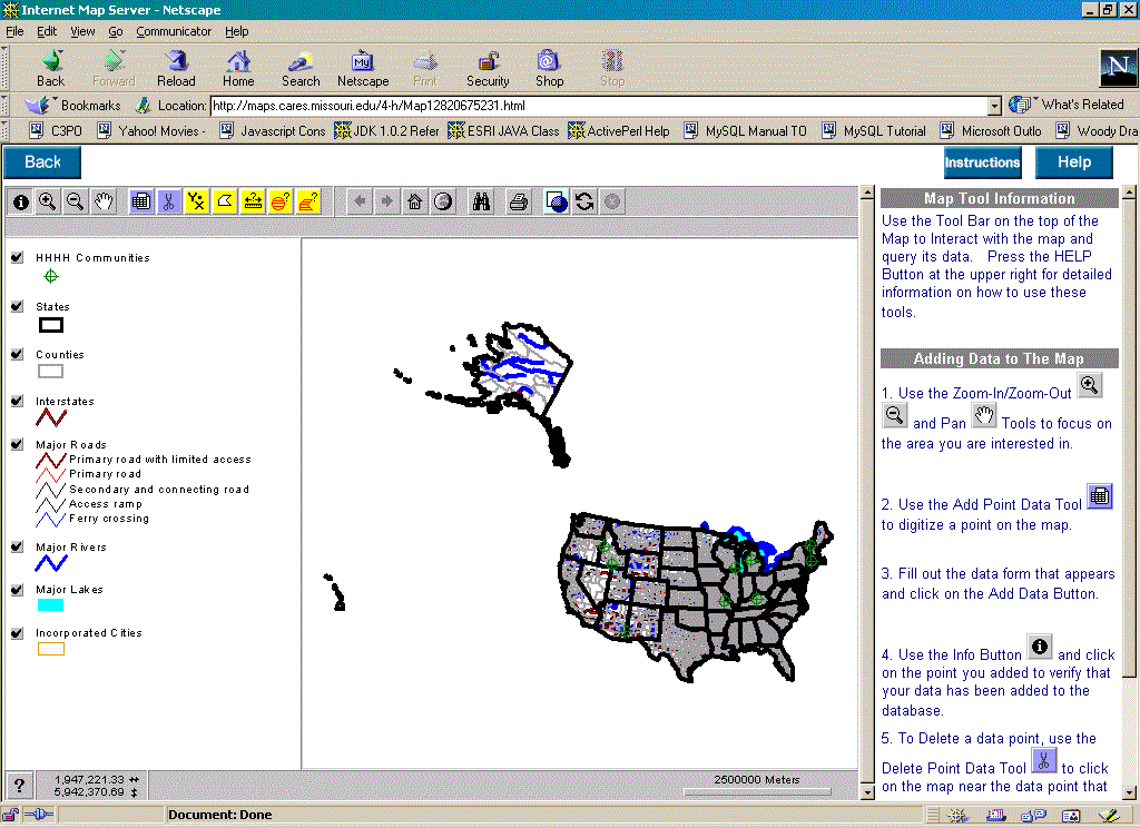
figure 1. Initial national-level user view
1. Allow 4-H members to locate their local organization's headquarters on a national map, similar to the push-pin maps seen at many national conferences but using WWW technology.
2. Present each user with a survey tailored by the conference organizing committee to gather information on internet access issues in each community represented at the conference. Use the WWW front-end to populate a database with responses that the committee could analyze statistically and spatially.
3. Demonstrate the capabilities of WWW-based GIS and interactive mapping in general to an audience that may not be familiar with GIS.
The authors view this application as a prototype that demonstrates how WWW-based GIS can be used as a tool for addressing community development issues. Often, when an issue of national or international scope is addressed, it is discovered that much of the relevant information is only known or held at the local level. The sheer volume of data describing relevant local conditions in thousands of communities distributed across the entire nation can be staggering. Much of this critical information describing local conditions is perishable. The volume of information collected and the necessity to construct a time-sensitive snapshot of conditions across a wide area makes a centralized data entry approach impractical. Locally-based knowledge needs to be collected using a decentralized approach so that spatial trends and variations can be understood and taken into account when policy decisions are being made by a national organization.
1. The mapping pane, similar to a display in ArcView, contains the map graphics.
2. The table of contents to the left of the mapping pane is also analogous to ArcView. It allows the user to toggle the visibility of the various GIS layers in the mapping pane.
3. The toolbar above the mapping pane contains buttons and tools that provide the interactive functionality of the application. Custom tools that allow the user to add a data point, delete a data point, and query the map in various ways are provided along with standard built-in functions such as pan, zoom in, zoom out, etc.
4. The information frame is to the left of the mapping pane and provides a place to display text and tabular information to the user. Initially it contains instructions and help information. As the user interacts with the application and queries the underlying GIS layers, the results of the queries are displayed here.
5. Pop-up dialogue windows are created by some of the tools to provide data entry forms to accept user input.
figure 1. Initial national-level user view
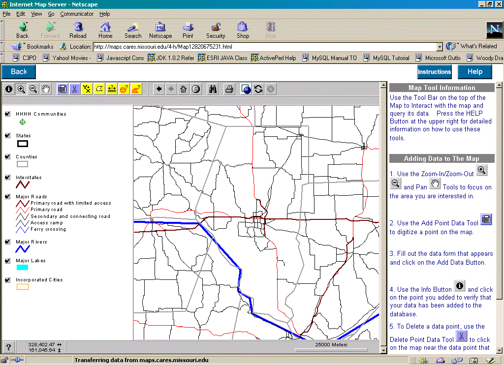
figure 2. County-level zoom with more detailed roads
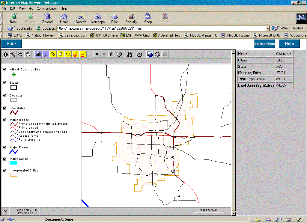
figure 3. City-level zoom with urban boundaries
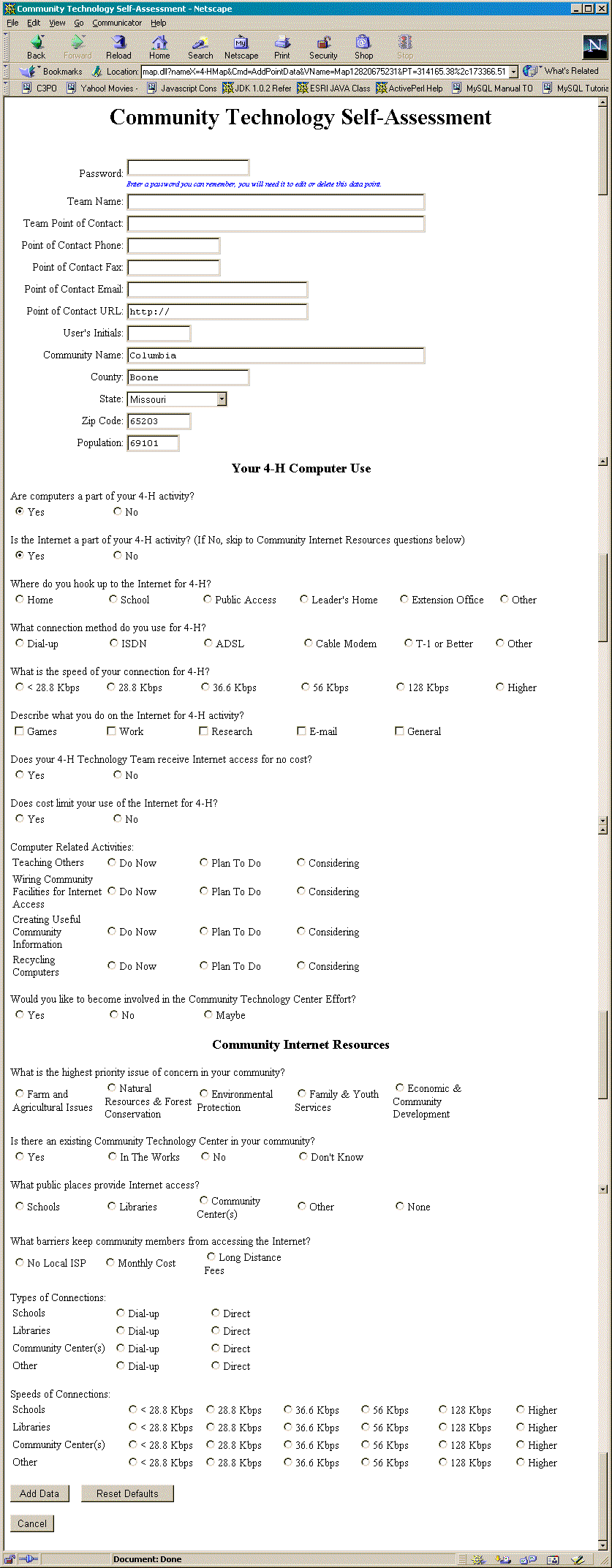
figure 4. "Community Technology Self-Assessment" data entry form tied
to a point location on the map.
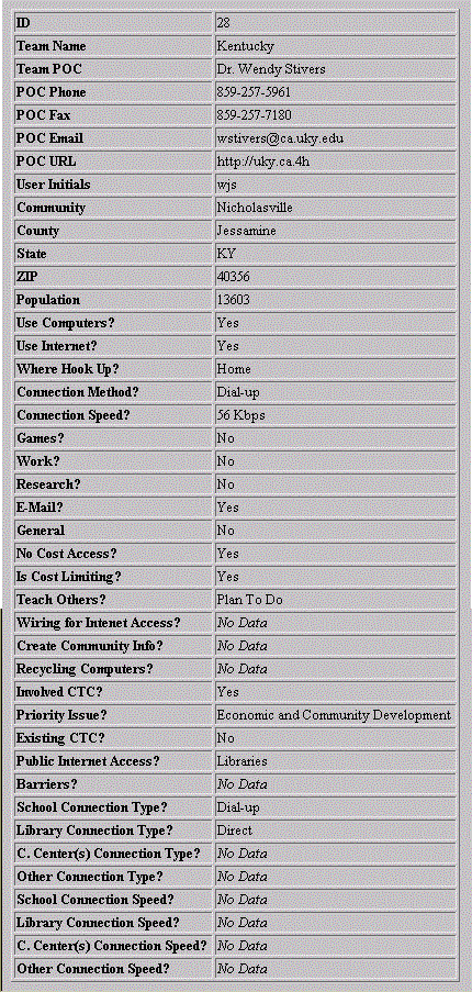
figure 5. Results of "feature information button" query on one of the 4-H Communities |
figure 6. Results of "feature information button" query on a county |
There are a number of other specialized query tools included to demonstrate GIS capabilities. There is a "radius query tool" that the user may use to digitize a point location, specify a radius and select a GIS layer of interest. The "radius query tool" constructs a circle from the point and the radius, intersects the circle with the specified GIS layer and returns a list of the features from the layer that fall within the circle or intersect it. There is also a similar "polygon query tool" that allows the user to interactively digitize a polygon of arbitrary shape on the map; this shape is then used to query the selected GIS layer and list the selected features as with the radius query tool. The "find tool" can be used to search the attribute database for one or more GIS layers to match a search string entered by the user; a list of features containing the desired text string is returned and by selecting one, the user can zoom in to the feature on the map.
Other basic GIS tools are included as well. There is a "coordinate tool" that returns the latitude and longitude coordinates of any point on the map selected by the user. The "distance tool" is available to measure linear distances between points on the map. The "area measuring tool" functions like a planimeter allowing the user to interactively trace the boundaries of an arbitrary area on the map to calculate the enclosed area.
At the time of this writing, the application is still being served and
can be accessed at www.4-h.missouri.edu.
The 4-H interactive mapping application was implemented using Esri's
ArcView Internet Map Server (AvIMS) technology. AvIMS is an extension to
ArcView 3.x that uses client-server technology to allow the user's web
browser (client side) to transmit requests to an ArcView project running
on the server. The ArcView project responds to these requests, performs
GIS functions and returns graphic images and html content to the user's
web browser. HTML, JAVA, and JavaScript can be used on the client side
to customize the web application, control the look and feel of the user
interface, and receive user input while Avenue programming is used on the
server side to perform the corresponding GIS and database operations and
to serve the data to the client (figure 7).
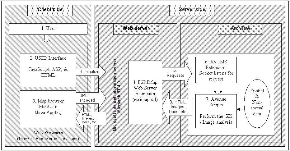
figure 7. Client-server architecture
This 4-H Interactive Mapping Application was instrumental in demonstrating the possibility of developing a national scale WWW-based GIS for collecting locally-based knowledge through a distributed data entry mechanism. This work served as a catalyst for the development of the Rural Policy Research Institute (RUPRI) Community Informatics Resource Center at the University of Missouri - Columbia. This site can be accessed at www.rupri.org/circ.
H. Archer, and P. Croswell, Public Access to Geographic Information systems: An Emerging Legal Issue, Photogrammetric Engineering and Remote Sensing, 55, No.11, (1989).
S. Langaas, Commercial, off-the-shelf solutions for GIS WWW interfacing, http://www.grida.no/prog/norbal/docs/giswww/giswww.htm (1996).
Z. Peng, 1997. An Assessment of the Development of Internet-GIS, http://gis.Esri.com/library/userconf/proc97/proc97/to550/pap526/p526.htm (1997).
Z. Peng, and D. Nebert, An Internet-Based GIS Data Access System, Journal of the Urban and Regional Information Systems Association, 9, No.1, (1997).
B. Plewe, GIS-Online: Information Retrieval, Mapping, and the Internet, OnWord Press, Santa Fe, NM, (1997).
Chris Fulcher, Ph.D., Co-Director, Center for Agricultural, Resource and Environmental Systems (CARES), and Director, Rural Policy Research Institute (RUPRI) Community Informatics Resource Center, University of Missouri - Columbia, FulcherC@missouri.edu