Controlling Livestock Diseases with the Help of an Internet Map Server
Susan A. Maroney and Jerome E. Freier
U.S. Department of Agriculture, Animal and Plant Health Inspection Service
Centers for Epidemiology and Animal Health
Fort Collins, CO
Abstract
An Internet Map Server (IMS) is the newest tool in the USDA's Animal and Plant Health Inspection Service's (APHIS) toolbox for combating disease in animals and plants. Economic impacts of disease outbreaks in livestock animals, wildlife, and plants are significant within the U.S. as well as abroad, because our export trade is affected. USDA has a geographically dispersed workforce of veterinarians, epidemiologists, wildlife officers, and plant protection officers who must coordinate extensively during an outbreak, in addition to their daily work. Data on animal and plant distributions, disease locations, environmental characteristics, insect vectors, and transportation routes are among the data needed to help identify the source and predict the spread of disease. An IMS will allow the rapid dissemination of these types of data, will enable analysis at several locations using shared and local data sources, and will serve maps showing spatial and temporal aspects of the disease outbreak. Using an Internet Map Server, hypotheses on source and spread of diseases can be posited, exchanged, and tested. This speeds up response to and recovery from an outbreak. Day-to-day access to data on populations and surveillance information prepares the workforce for future response to disease outbreaks. The APHIS Internet Map Server will be applied to such diverse issues as cormorant predation on catfish farms and monthly reporting of livestock diseases by international organizations.
Introduction
Internet Map Server (IMS) technology helps to remedy a longstanding weakness in Veterinary Services' (VS) animal agriculture operations: it disseminates spatial data about animal health and populations at variable geographic resolutions to animal health officials nationwide, facilitating coordination both periodically for day-to-day operations, and hourly or more frequently during animal disease emergencies.
Spatial analysis and geographic information sciences have been used for many years to manage human health issues. These techniques are similarly applicable to animal health issues. GIS and spatial analysis are integral processes in health management that provide data visualization, exploratory data analysis, and an array of special tools for model building. Each of these processes can play a significant role in enhancing knowledge about how disease agents are maintained in nature, as well as mechanisms of disease spread through populations. An IMS extends the distribution of spatial data and analysis to a wider audience. With an IMS, it becomes unnecessary for users to purchase GIS software to manipulate spatial data and perform analyses - this is accomplished via an Internet browser interface. The mission of USDA's Veterinary Services, preventing, controlling and/or eliminating animal diseases, as well as monitoring and promoting animal health and productivity, requires a broad range of expertise. Veterinary Services' veterinarians, epidemiologists, wildlife biologists, ecologists, and disease managers, while specialists in their field, usually do not have training in GIS software. An IMS allows them to utilize spatial data in their jobs via a web interface without any extra training or software. As a final advantage, that work force is distributed nation-wide, with international offices throughout the world, and an IMS makes data and spatial tools available uniformly.
The health of the livestock industry has an enormous impact on the U.S. economy. In 2000 the value of the combined livestock and poultry industries in the U.S. was estimated at $100 billion by the USDA. The number covers cash that farmers receive from sales of meat animals, dairy products, and poultry products.
Veterinary Applications for Web-based Spatial Data
Emergency Operations
The USDA plans extensively for animal health emergency response. Part of that planning is implementing Internet-based mapping capabilities to support all four phases of emergency management - Planning, Preparedness, Response, and Recovery. The Planning stage involves anticipating which disease agents have the greatest potential to become actual threats. Much of the Planning occurs as part of daily operations, such as identifying critical case and environmental data, and establishing contacts with all levels of government, industry associations, and academic institutions. In Preparedness, critical data are collected and assembled in a core GIS database. This database can be made accessible via an Internet map server to authorized users. In the U.S., there are no databases of individual livestock and poultry animals with a unique identifying number, address, and health history. These data need to be collected and maintained. A national effort will commence shortly to collect geographic coordinates for animal aggregation facilities including markets, feedlots, and slaughter establishments. It is even possible to enter data remotely into a spatial database using a web interface, for regions or countries without GIS software or equipment.
It is in the Response phase that an IMS can be used to its fullest potential. Web-based forms can be used to collect disease data on farms and ranches and to check the quality of the data. Then, from a spatial database, data are updated and available to the field force, analysts, and managers simultaneously. Web-based data can produce maps for orientation in the field, and to route investigating veterinarians to minimize risk of spreading the pathogen further. Analysts can apply spatial statistical techniques to the data to assist the epidemiologists in predicting the spread of the disease. They can posit, exchange, and test hypotheses of disease transmission and risk using disease definitions, ecological data, insect vector distributions, and local climate conditions. Web-served and local data sets can be combined using an IMS for these analyses. Managers can have instant access to interactive views of the latest case locations without waiting for that information via phone, fax, or email. And there can be general public access to data on case locations, animal movement or travel restrictions, and methods to avoid contracting the disease. Finally, in the Recovery phase, retrospective analysis and assessment of the outbreak's impact can be distributed via the IMS, as well as coordination of cleanup and surveillance activities.
Daily Operations
Spatial analysis and geographic information science lend themselves to spatial and temporal analyses so valuable in disease management. One of the most important functions GIS can play is disease surveillance and the development of spatially-based, disease detection systems. Using a spatial statistical approach would improve disease reporting such that disease rates and other health statistics could be described by geographical area. This process would also support a zonal or regional strategy to define disease boundaries. GIS methods permit better ecological analysis of the natural maintenance and transmission mechanisms of disease agents. Environmental factors that help to maintain a disease agent can be identified through statistical and spatial analyses of individual components, separately or in combination. GIS and spatial statistical tools can be used to identify disease clusters and evaluate aggregation strength based on distance dependence of case sites. For animal health surveys, GIS methods can be used to geographically order population samples for spatial comparison. As health needs are identified, GIS techniques can be used to determine whether resources are allocated adequately.
To accomplish this, and in support of the Planning phase of Emergency Management, critical data are identified and tagged as to whether they exist or need to be gathered. An IMS contributes to daily operations by serving as a data collection and distribution mechanism. Disease surveillance efforts take advantage of the full range of data available and pursue spatial avenues of investigation.
One of the most important decisions in an epidemiological study is that of scale. The scale level should be appropriate for the issues being investigated in an analysis, otherwise the results will not be meaningful and may be misleading. A map service can alleviate the issue of scale by allowing users to zoom to a scale appropriate to their analysis. Also, the site administrators can set the scale of individual themes to prevent them from drawing at scale too detailed or too general for accurate analysis. Thus, an IMS supports and, in fact, encourages multi-scale analyses. In addition, via an IMS, several other spatial analysis tools become available: querying, buffering, and overlay analysis.
Veterinary Services Map Services
An IMS server currently resides at Veterinary Services' Centers for Epidemiology and Animal Health in Fort Collins, Colorado and multiple web-based map services are in development for VS and for Wildlife Services.
The first project is a spatial data library. It will contain detailed base map data for the United States. Base map data include administrative boundaries at the county, township, and municipality level. Other information that will be maintained are data on livestock and poultry populations, wildlife populations, arthropod vector distributions, weather and climate, terrain, and hydrologic features. Supplemental data will include satellite imagery, aerial photography, and rasterized maps. These data are currently being collected and the IMS will be developed shortly, to support daily and emergency operations of VS. A spatial data library may also include publication of data on livestock diseases in the U.S., allowing for trend analysis of data to discern patterns, build models, and test hypotheses on maintenance cycles.
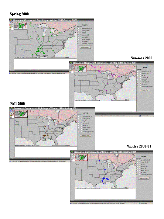
The second web-based mapping project data concerns loss of farm income due to wild birds preying on game fish. In collaboration with USDA's Wildlife Services, VS is hosting a web-based map service to track sightings of double-crested cormorants outfitted with telemetry devices. This predation is a seasonal problem, so knowledge of bird locations as they migrate throughout the year is necessary for intervention and mitigation.
The following figure displays four screens from the map service on cormorant migration. It shows the locations of 53 cormorants over the course of spring, summer, and fall of 2000 and the winter of 2000-01. These maps are accessible by members of the public, and, in particular, will be useful to catfish and other food and game fish farm operators in planning mitigation techniques to minimize predation. The intent is to update the data monthly.
Specialty map servers to track diseases of particular concern constitute the third type of map server. One example may be diseases whose clinical signs closely resemble other diseases and whose diagnosis must therefore be checked carefully. Another example may be diseases of regional interest. These map servers would be accessible by select groups of animal health officials to monitor national and regional animal health.
The fourth project entails the establishment of a web browser-based data entry system. This IMS would allow under-developed countries to locate and report disease cases using a point-and-click interface on a web-based map. These data could be converted to a database for further analysis and sharing. This approach eliminates the need to purchase and learn GIS software.
Conclusions
Internet Map Server technology is an enormously powerful tool that enhances VS' ability to promote and protect America's animal agriculture. As well, the Wildlife Services and Plant Protection & Quarantine units of APHIS are pursuing web-based mapping applications in such areas as wildlife management and crop pest tracking. For VS, increased resources, especially manpower, applied to creating, customizing, and maintaining map services, will be necessary to meet anticipated usage. Collaborations with other government agencies are being investigated to maximize the potential of web-based mapping for disease management.
Author Information
Susan Maroney
GIS Specialist
Veterinary Services, Centers for Epidemiology and Animal Health
Animal and Plant Health Inspection Service, U.S. Department of Agriculture
555 S. Howes Street
Fort Collins, CO 80526
voice (970) 490-7894
fax (970) 490-7999
susan.a.maroney@aphis.usda.gov
Jerome Freier
GIS Research Analyst
Veterinary Services, Centers for Epidemiology and Animal Health
Animal and Plant Health Inspection Service, U.S. Department of Agriculture
555 S. Howes Street
Fort Collins, CO 80526
voice (970) 490-7974
fax (970) 490-7999
jerome.e.freier@aphis.usda.gov