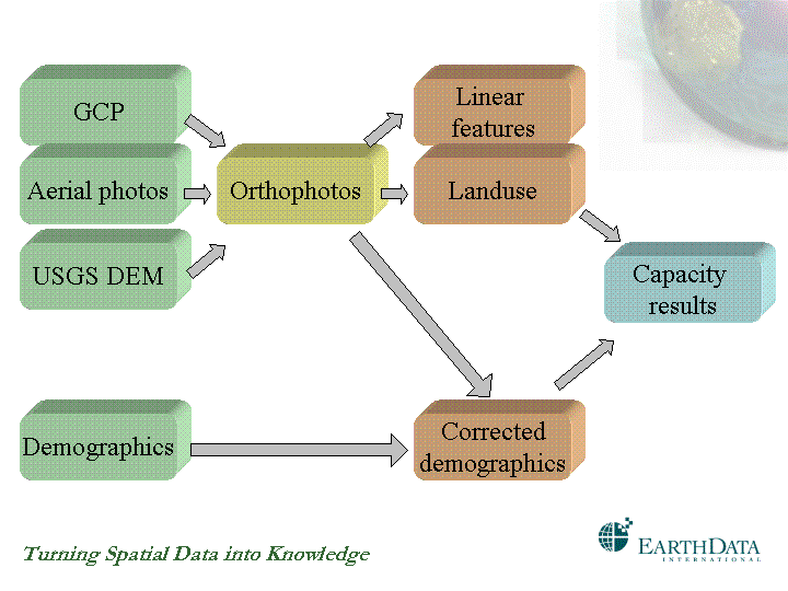
Figure 1: This graph represents the workflow that computes a growth capacity map. Each box corresponds to the process that results in the dataset named in its label. The arrows indicate the dependency among datasets, reflecting their lineage. The evolution of that dependency is color-coded, from left to right. Two processes with the same color can be executed in parallel.
As the project is successful they want to repeat the experience the next year, wanting also to understand the evolution between the two years. New photography is contracted, and this time there is money to compute the orthos from the stereo pairs. What happens: the new landuse follows the new geometry, not the old; but the demographics layer remains with the old definition, but needs to be corrected to the new geometry in order to be able to perform the new analysis. The overlap required for the multitemporal study needs to match both years’ results. Typically all this work will be manual and costly.
In the next section, the same example is reviewed using a different approach, by having a new model in which derived layers can automatically follow the geometric changes undergone by its “dynamically linked” sources.
It is worthwhile to note that routes and regions introduced in former ArcInfo releases can be considered as early references of the concept presented here, strongly limited by the underlying technology available at the time. Having census tracts defined as regions over a network of centerlines, any modifications to the centerline geometry would result in the automatic alteration of the census tracts.
The metadata synchronizer present in ArcCatalog constitutes an important reference to our work. The synchronizer completes as much of the metadata as possible automatically, assuring that metadata is kept up-to-date with changes to the data set. We will take this concept further by providing a two-way synchronization between data and metadata.
From neural networks architectures [6] and learning rules, several ideas have been drawn about how knowledge is propagated among the different elements of an artificial neural net (ANN). Even though we are not using the ANN technology per se, many useful analogies have been exploited.
Adding “intelligence” to basemaps
The quality of the attribute information is as crucial as the geometry, and it can be maintained using Esri geodatabase techniques described elsewhere [2], using domains, rules and so on. The main focus of this paper will be in geometric features, where one of the most critical challenges resides.
“Intelligent basemap” is herein defined as a geodatabase that incorporates behavior into their constituent layers such that:
- They are aware of its lineage (i.e. landuse knows that derived from those orthos).
- They know how they inherited the geometry from their source data (i.e. orthos knows their interior and exterior orientation parameters, the DEM from which they were created, and the resulting geometric transformation map).
- If there is a change in a source layer a forward propagation occurs, such that the new geodatabase is consistent and more accurate. By propagation we mean correcting the geometry of every feature dataset that is derived from the changing layer.
A metaphor for the intelligent basemap is the conventional spreadsheet, like MS-Excel. Instead of storing fixed cell values and every time there is a change, get a calculator, make all the calculations externally, and manually edit the results, the formula of how to compute them automatically are kept, such that changes are taken care of on they own, leaving the spreadsheet in a consistent state at all times.
Although the idea is simple and straightforward, applying the same concept to geometry is far more complicated. However, object-oriented technology [1,4] and the ArcObjects framework [5] in particular make this possible.
The following benefits can be highlighted:
- Integrity and quality of the geodatabase.
- Easier/faster editing and updating.
- Extremely efficient support of derived geometry and metadata.
Equivalent ideas have been successfully applied in the field of Computer Aided Design/Computer Aided Manufacturing (CAD/CAM), where tens of thousands of 3D parts are designed and assembled parametrically, in such a way that if any of them is altered, the impact is reflected immediately in the whole model, providing instant feedback to the engineer designing a particular piece. Although the context is different and that technology cannot be utilized for mapping purposes, the principles and the benefits are comparable.
Having this new technology in place, how does it make the previous example different?
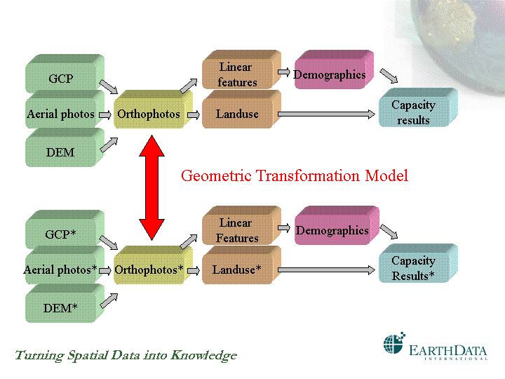
Figure 2. The two workflows represent the same work done with a difference of one year in time and with different accuracies. By computing a geometric transformation model only between the old to the new basemaps, vertical and multitemporal automatic integration of all other layers is guaranteed. Datasets marked with a asterisk (*) are the new data, while those unmarked represent the old data in the appropriate geometry, being its original or transformed.
The upper workflow in Figure 2 produces the same result as the one depicted in Figure 1, but it has been redesigned, such that the corrected demographics layer this time is computed from the linear features derived in turn from the orthos. Even though it will be more work the first time, if any of the sources changes, the demographics will be adjusted accordingly. For instance, if the USGS DEM with 30 meters postings is replaced by a more accurate DEM with 30 cm contours, the orthos can be recreated and a “geometric” forward propagation occur.
The lower workflow in Figure 2 represents the new job, where the new data is marked with an asterisk (*). Establishing an automatic correspondence between the new orthos and the old ones, it allows to transform every other pixel or vertex of every other layer. In the example, the linear features and the demographics layers have been transformed through this vector field to match the new geometry, instead of being rebuilt. Undoubtedly the most interesting thing is what happens if the linear features are captured again with higher accuracy. Then, the demographics layer will inherit the new accurate geometry automatically, and so will its descendants.
The next section, describes the technology that makes this possible.
Base technology
Briefly some of the technologies that could make this vision possible are mentioned.
Faster and more accurate data capture / processing techniques
Even though this may not seem as strictly related to the concept of “intelligent basemaps”, it is in fact its most important component for two reasons. First, if the data is not captured and produced timely and with the required level of detail, nothing can be done later to fix it. Second, the data captured, remotely or in the field, are always the first links of the lineage chains (or graphs) for any other existing dataset in the geodatabase.
In the raster domain, Earthdata has a broad set of sensors, covering wide ranges in speed of acquisition and/or processing, in spectrum, in levels of detail and swath coverage.
- GeoSAR. Produces DEM with 1-meter vertical accuracy (and < 3 m under foliage), with all-weather operational capabilities and extremely fast (160 sq. km per minute).
- LIDAR to generate DEM with an accuracy of up to 15-20 cm.
- Multispectral sensor.
- Digital camera.
- Conventional aerial photography including ABGPS and IMU.
- Helio (Short Take-off and Landing). Low-altitude aerial photographs with 1.25 cm vertical accuracy for engineering work.
On the vector domain, the ability to collect real-time GPS (or differential GPS) measurements in the field, connected to a PDA, and linked to the Internet via wireless protocols to an ArcIMS server, offers new opportunities for on-time, accurate basemap updating.
Lineage graph
This concept requires to store for each object not only its latest computed coordinates, but also information about the formula or process that produced those coordinates.
In the case of raster layers, the rectification or the ortho-correction process that produces the geometric transformation map should be stored (i.e. a vector field associating each pixel of the original with the new position in the corrected image). In the case of a rectification, the transformation map is a polynomial with few coefficients, dependent on the ground control. Ortho-correction processes produced a more complex transformation map.
The simplest example is an image rectified through an affine transformation. If the GCP are measured more accurately, the coefficients change, and the image geometry can be updated accordingly. The new polynomial can now also be applied to all the derived layers, both raster and vector.
If the data is collected in vector form, it is more complicated, because it is necessary to keep track of all the sketch construction commands [3], parameters and constraints entered during an editing session. For instance, if a point coordinates are computed as the intersection of two circles, that information with the circle centers and radius are stored as part of the object. If one of those centers moves, the other point should follow.
Note that the lineage information until now was only kept in the metadata base as a textual description of the origin of the data, for visualization purposes only. Such unstructured information is not enough to automate conversion processes to this new technology, so it has to be done manually once. From that moment on, data and metadata become fully synchronized, and changes in one are reflected in the other immediately.
Multiresolution matching
Whenever there is an increment in the level of geometric detail, both raster and vector, we need to be dealing with multiresolution algorithms to establish the correspondence, automatically or semi-automatically, between the same objects at the two scales.
In the example of Figure 2, in order to compute the geometric transformation model between the two sets of orthophotos, given that they have different scales, it is necessary to use appropriate algorithms that can perform automatic matching at different scales. Similarly, for vector datasets, new conflation tools are being developed following similar principles.
Conclusions
A new concept has been presented in the area of basemapping that can substantially reduce the efforts of maintaining and updating existing geographic databases. The integration of technologies, from new sensors for more effective and efficient data capture, to the object oriented paradigm and Esri ArcObjects, could produce a dramatic impact in the future of basemapping.
References
[1] Bahar, M., Object Technology Made Simple, Simple Software Publishing, 1996.
[2] McDonald, A., Building a Geodatabase, Esri Press, 2000.
[3] Shaner, J., Wrightsell, J., Editing in ArcMap, Esri Press, 2000.
[4] Taylor, D., Object Technology: A Manager’s Guide, Addison-Wesley, 1997.
[5] Zeiler, M.., Exploring ArcObjects, Esri Press, 2000.
[6] Hagan, M., Demuth, H., Bealle M., Demuth, B., Neural Network Design, Pws Pub Co, 1995.
Blake Burns
Director of Business Development
Earthdata International of Florida
701 Brickell Avenue Suite 1490
Miami FL, 33131
Phone: 305.377.1601
Fax: 305.377.1602
bburns@earthdata.com
Eduardo Viola
President and General Manager
Earthdata International of Florida
701 Brickell Avenue Suite 1490
Miami FL, 33131
Phone: 305.377.1601
Fax: 305.377.1602
eviola@earthdata.com
Gabriel Carballo, PhD
GIS Project Manager
Earthdata International of Florida
701 Brickell Avenue Suite 1490
Miami FL, 33131
Phone: 305.377.1601
Fax: 305.377.1602
gcarballo@earthdata.com