The City of Indianapolis/Marion County GIS is in the process of developing a comprehensive ArcIMS web-mapping interface. The framework includes a common web interface that incorporates a system of diverse GIS applications. The design phase will take existing applications, both web and desktop, and merge them into a common system that accommodates both internal and external GIS users. The final implementation allows for increased expandability and future application integration.
The City of Indianapolis/Marion County GIS has evolved greatly since its beginnings in 1986. Currently the GIS Division supports more than 500 ArcView users, and since May of 1999, has developed five Internet applications. As the GIS user community continues to grow within the enterprise, the way in which the GIS Division serves its users needs to change also. One of the problems with having such a large number of users in the enterprise is the cost of maintaining 500 ArcView licenses and the support costs that are associated with this. Another problem is the desktop nature of ArcView, meaning there is the need to touch each user's machine to upgrade applications with new versions.
When Esri came out with their new Internet mapping software called ArcIMS, the City of Indianapolis/Marion County GIS Division researched it and decided that ArcIMS would be a good software choice to meet the needs of the users in the City/County enterprise. There were two main reasons for the City of Indianapolis/Marion County GIS to migrate to the new ArcIMS platform. The first reason was that ArcIMS provided the GIS Division a way to reduce the number of ArcView licenses, thereby reducing maintenance costs and upgrade time. The second reason was that ArcIMS provided the GIS Division a way to better serve the public by having the ability to develop and deploy new Internet applications quickly. Once the choice was made to use ArcIMS the next step was to develop a plan for use and implementation. The goal of the City of Indianapolis/Marion County GIS was to develop a comprehensive web-mapping interface that would serve the needs of their users with the ability to expand down the road when necessary.
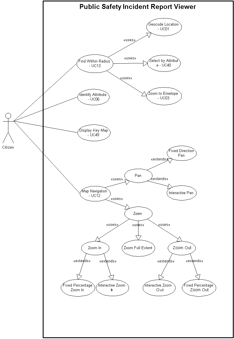
The approach to developing a comprehensive web-mapping system took a considerable amount of planning and preparation. The goal was to identify all the different potential uses of GIS web mapping throughout the 30 different divisions and agencies within the enterprise. The first task was to select a group of representative users and schedule interviews with them. The interview process took each user or group of users through a series of questions to determine how they currently used GIS and what they would like to be able to do with a web-based GIS application. After summarizing the notes for each interview, use cases were extracted. From this process 52 different use cases were identified in 22 separate applications. A pattern started to emerge with common overlapping components in the user’s desired applications. This was expected to occur and finding the commonality between the users was a significant achievement. After extracting use cases, use case diagrams were drawn using the Unified Modeling Language (UML). An example of one of these use cases diagrams is shown below in Figure 1.
|
| Figure 1. Example Use Case Diagram |
The diagrams provided a conceptual view of the different elements of each application and were created to determine and build component-based applications in which some of the components could be reused in other applications. This methodology allows applications to be completed faster since code will only have to be written once for each component. A second reason for using use case diagrams was that the diagrams made it easy to present the use cases in the applications back to the users. This was important to ensure good communcication between the users and the development team.
After determining all the use cases, each use case was assigned a number. The use cases were then tallied up throughout the various applications. As a means of prioritizing them, a use case was determined to be a higher priority the more times it appeared. The applications were then prioritized into a development order. The applications fell into four natural development stages. Coincidentally, the first set of applications to be developed also represented different user groups in the enterprise. This made the development schedule palatable to the diverse group of representative departments and agencies. A preliminary schedule for developing applications was set, however, the prioritization level of the applications was anticipated to change after the initial applications were developed.
Simultaneously as the use cases were developed, a generic HTML viewer with out-of-the-box functionality was developed to serve as a starting point for the ArcIMS comprehensive project. The web site was developed using some of the City’s most commonly used layers and was first put out internally for the GIS team to test. After initial testing, the general viewer application was made available to other internal users and eventually, after testing was complete, to the general public.
All throughout the process of developing the integrated web site, documentation was necessary. The ArcIMS project was the first time the Indianapolis/Marion County GIS team had reused code to build multiple applications at the same time. In previous projects, both desktop and Internet, applications were coded from the ground up for each application, one at a time. Since this project employed an iterative development of software components, it required the team to implement a different method of documenting user needs, application requirements, and site design.
While the applications were being developed it was necessary to begin thinking about the design of the overall ArcIMS web site. The goal was to develop a common look and feel throughout the various applications. An initial step in the design process was to visit other web mapping sites and decide what worked well and what did not, along with looking at the overall appearance of the site. Taking the time to learn from others was something that would be beneficial down the road as the project continued to develop. Another step in the design phase was to get user feedback. A meeting was held with the original interviewees in which different design possibilities were presented. The users were given a chance to provide their input on the overall design of the site. Together through these mechanisms, the design of the ArcIMS web site was created.
At the time of the 2001 Esri user conference, the City of Indianapolis/Marion County GIS Division has completed the out-of-the-box general viewer and one of the customized applications. The first customized application was an incident report viewer for the Indianapolis Police Department and the Marion County Sheriff’s Department. This application allows the user to type in an address and view incidents that occurred within an approximate half-mile radius of the address location. Requirements definition and initial development of three other first phase applications are also underway.
The next step in the logical progression of the comprehensive web mapping site is to complete the other identified applications. These applications include: DPW Street Maintenance Viewer, Demographic Data Viewer, Bus Route Viewer, Liquor License Notification application, Mayor’s Action Center On-line Request application, Mayor’s Office Communicator application, Neighborhood Association application, New Home Owner’s application, Park Locator, Park Projects Viewer, Planning Data Viewer, Polling Place Locator, Route Mapper, Township Administrator application, Water Monitoring application, Wellfield application, Zoning Information Browser, and an Economic Development application. While many of these applications are data viewer type applications, they all have one or more specialized functions. For instance, some require the ability to find the nearest feature, print a custom map, send a request form, or print mailing labels. All of these things the users asked for are not available in the out-of-the-box ArcIMS but can be done through additional programming.
As a final step in the integration of our ArcIMS comprehensive web-mapping site, the existing MapObjects applications that are not being replaced with a new application will be rewritten and be converted to the ArcIMS platform. Once the rewritten applications are deployed, the old MapObjects applications will be phased out.
In conclusion, the process of designing and implementing an ArcIMS platform was a long and involved process. However, the end result of having an integrated web mapping architecture helped the City of Indianapolis/Marion County save money on ArcView licenses and time for upgrade installation. The importance of documentation also proved to be important to ensure consistency and efficiency in developing the many applications required by the users. The emergence of ArcIMS provided a common web-mapping tool for Internet and Intranet, and a starting point for more easily intergrating future application development.