This paper presents the web-based Geographic Information System used by Tampa Bay Water, the largest wholesale water utility in Florida, in its day-to-day operations. This GIS furnishes interactive, web-based, applications focused on delivering water production, water level, rainfall data and on-going construction project information, including the largest reverse osmosis desalination water treatment plant in the western hemisphere. This tool also provides various query interfaces, data visualization and trend analysis capabilities to a staff of hydro-geologists, engineers, operators and public relations personnel. This paper demonstrates the value that a well-designed GIS can provide to the daily operation of a water utility.
Tampa Bay Water is a special district created by inter-local agreement to provide wholesale drinking water. Its member governments include Hillsborough, Pasco, and Pinellas counties, and the cities of New Port Richey, St. Petersburg and Tampa. As the region's sole and exclusive wholesale water supplier, Tampa Bay Water utilizes a network of facilities and manages an extensive environmental monitoring program and a state-of-the-art wellfield management plan.
Tampa Bay Water provides an average of 180 million gallons of drinking water to its member governments every day. Currently that water is produced from 12 regional groundwater facilities, two water treatment facilities and one surface water augmentation facility. Tampa Bay Water is a true regional utility with facilities located throughout the tri-county area and offices in each county that it serves.
To address the existing and future water supply needs of its member governments, Tampa Bay Water completed a comprehensive planning document that includes water demand projections as well as an examination of existing water supply sources and facility capacities. Tampa Bay Water proposes to develop a minimum of 85 million gallons per day (mgd) of new drinking water supply to meet the needs of the Tampa Bay community through the year 2010. This was implemented through a Master Water Plan approved in 1995. The first phase of the Master Water Plan broke ground on September 15, 2000.
Water utilities, with spatially distributed facilities, detailed environmental monitoring, comprehensive environmental and water level related operation plans, and on-going planning and management of new water supply and facility projects, have great demand for sophisticated GIS applications. A properly implemented GIS system will result in resource productivity and cost effective information management, and, therefore, improve the performance of water utilities operations.
Tampa Bay Water has implemented an Information Data and Maps (ID&M) system as a tool to assist in the planning, operations, information management and other day-to-day activities of the Agency.
GIS is an ideal tool to visualize and analyze water production, water level, rainfall, and other collected and monitored environmental data. A GIS system makes the water demand analysis more accurate by providing spatial analytical information about actual populations served and water usage by service areas. The spatially distributed results gives guidelines for facility planning to meet future demand.
An Optimized Regional Operations Plan (OROP) was established to ensure that water demand for the tri-county region can be met with minimal adverse environmental impacts. The plan was developed based on GIS data, spatial GIS layer manipulation results, and sophisticated computer models analyzing and forecasting groundwater and surface water conditions at water supply facilities.
GIS is the primary tool in the implementation of the residential well mitigation policy. Mitigation zones are created by buffering production wells. Residential well location is verified respective to the mitigation zone. Proper procedure can be taken to resolve the well problem if the domestic well has a water-level-related problem.
When planning and studying new projects, spatial data and sophisticated GIS tools are necessary to conduct thorough environmental assessments to determine if the potential project is environmentally sustainable. Analysis results may lead to the relocation or rerouting of the project with less impactive alternatives.
Tampa Bay Water has implemented and continues to develop a GIS utilizing client/server
technology with ArcSDE as the GIS database manager. Tampa Bay Water currently has an
Enterprise data model that incorporates multiple servers containing several MS SQL server
databases within its local area network. These severs include:
� GIS SDE server that contains the existing
planning level GIS data;
� Facility management server that contains the
facility component data, work orders, and the well and monitoring data;
� SCADA server that contains the information
being automatically monitored.
Organizations with centralized data warehouse and distributed users are excellent candidates for web-based GIS solutions. This technology allows applications to concurrently manage user requests and eliminates the need to install multiple desktop applications. In Tampa Bay Water, a network-based architecture, balanced between database access and GIS support, was implemented based on the demand in data sharing and project management.
The goal of the ID&M system is to effectively integrate and distribute environmental, project related information and data as well as provide user-friendly GIS capability over the Intranet/Internet. There are three separate client server applications, the GIS planning info service, the GIS environmental info service and the Master Water Plan projects construction info service. The GIS planning info service provides many spatial layers that assist in the planning and design of pipelines, pipe alignment studies, water treatment plants, public involvement information, and other wellfield-related activities. The GIS environmental info service provides an interface to retrieve and/or visualize current and historical water production, rainfall, and water level data for each monitoring point. The Master Water Plan projects construction info system provides the summary and latest information for the undergoing construction or coming up critical issues of the selected project.
The web-based GIS applications are client sever applications that are accessible from web browsers over Intranet and/or Internet. Server programs, residing and running on the server machine, handle all the requests that users submit through a client interface, either an HTML form or a program running under a web browser. The server programs also handle all the data access activities and GIS spatial manipulations. The client programs interact with users and communicate with server programs, through user-friendly interfaces and enhanced client side functionality.
As a client server application, web-based GIS applications can have many different system architectures. Esri's MapObjects and MapObjects Internet Map Server software package provides an excellent framework for a scaleable and flexible server side GIS application. At the client side, there are many options and various approaches to obtain the goal. Client interface varies from very thin client to heavy-weighted thick client.
An extreme example of thin client is a pure HTML web page with a clickable image and a form to store data and pass requests to the server. It is created online by the server application, and the whole interface is updated every time the server responds to its request. For a thin client, its client side functionalities and interactivities are very limited, and all the functionalities are implemented at the server side. On the other side, a heavy-weighted client can be a full-scale application program. It gets the feature data streamlined from the server. It has user-friendly interfaces and performs a lot of functionalities on the client side, including feature identification and spatial overlay. ArcIMS Java viewer with streamlined feature data is an example of a thick client.
Functionality, user interface and system performance were identified as three major objectives for the web-based GIS applications developed in Tampa Bay Water. Based on the requirements on those three aspects, a balanced client server architecture was implemented. Client side functionality is important not only because it provides better interface and interactivity, but it also eliminates unnecessary traffic between the client and the server. Therefore, better system performance can be achieved with less network traffic.
Tampa Bay Water has two data server machines, an Enterprise data server and a GIS data server. These servers run the agency's enterprise database in Microsoft SQL Server 7 and the GIS database in Esri SDE 3.2 respectively. The GIS web server is setup to run the MapObjects and MapObjects Internet Map Server application. Figure 1 shows the system setup implemented at Tampa Bay Water.
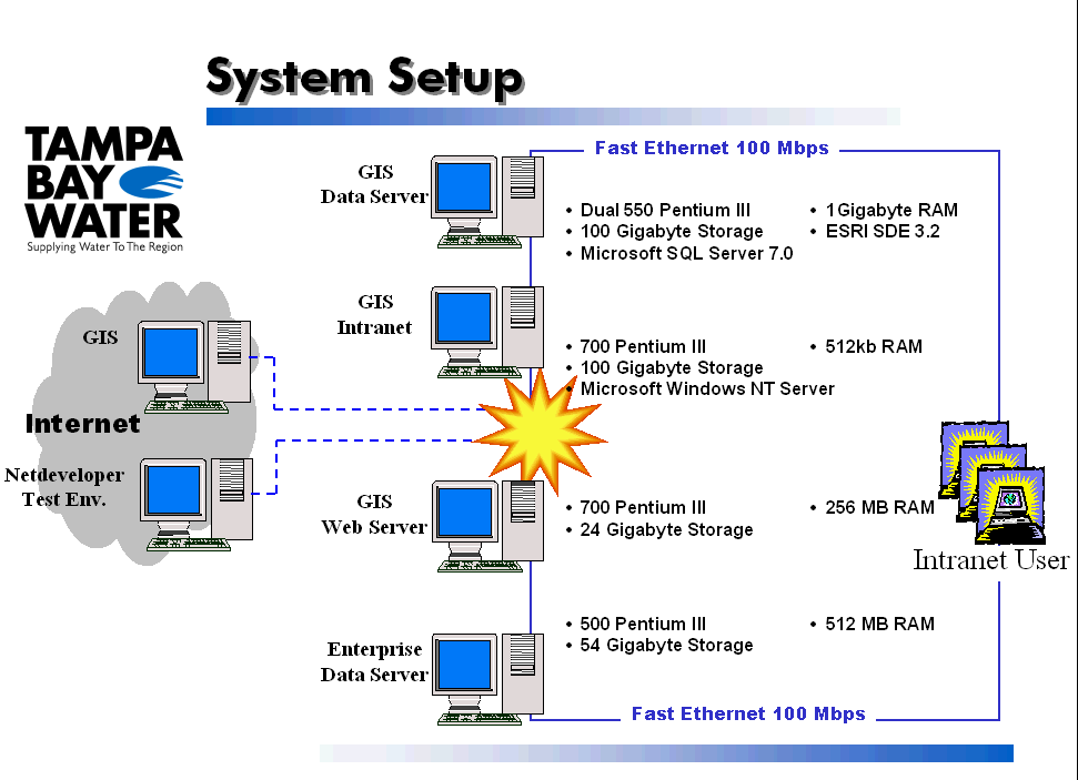
The server applications are developed using Microsoft Visual Basic Version 6. Microsoft ActiveX Data Object (ADO) is used to access the enterprise database constructed in Microsoft SQL Server 7. MapObjects 2.0 is used to visualize and manipulate spatial data stored as Esri SDE layers or shape files on the GIS data server. MapObjects Internet Map Server 2.0 is used to handle the communication between the server and the client and export maps as images to pass to the client interface.
The client interfaces are developed in Java as Java applets embedded in the web page written in HTML and JavaScript. The Java applet communicates with server application to send out requests and receive returned data and/or maps. It handles all the user interactivities and updates the display of image and data received. It also carries out the client-side functionalities such as automatically generating scale bar, legend and locator map. Using Java, instead of scripting languages such as JavaScript or VBScript, to develop the client interface brings in a more powerful development environment, enables flexible user interactive events and effects and releases the server from the task of managing the client interface.
Web-based GIS applications should have very user-friendly interface at client side and comprehensive data access and GIS manipulation capability at server side. Its functionality includes interactive map, spatial analysis tool, database query, and data visualization. All web-based GIS applications have the general GIS functionalities. Each system also has application specific functionalities.
The common interactive GIS functionalities in all the web-based GIS applications developed in Tampa Bay Water are basic interactive mapping tools, dynamic legend, dynamic scale bar, measuring tool, navigational locator map, and a print out interface.
The following basic mapping functionalities are provided:
� Zoom in - centering the map around the mouse click location and zooming in by a certain
percentage, or zooming to the user dragged rectangle;
� Zoom out - centering the map around the mouse click location and zooming out by a certain
percentage, or centering the map around the center of the user dragged rectangle and zooming out
according to the ratio of the map size to the size of the user dragged rectangle;
� Pan - centering the map around the mouse click location or moving the map view as user
dragged the map around;
� Selecting layers - turning layer on or off.
A dynamic legend and scale bar are created on the client side to reduce the load on the server and the communication between the server and the client. The legend will automatically update according to the data layer displayed and shows the quantity ranges of the color classification of the query results if applicable. The scale bar is recreated each time the map is updated. The scale is calculated at client side, and an auto-fitted scale bar either in mile/kilometer or feet/meters respectively is displayed.
A client-side measuring tool is developed to enable users to measure distances interactively on the map. A user can measure distances by clicking the mouse on the map. The measuring line and length of the line in both feet and miles are displayed on the map, and a total distance is given at the status bar in both feet and miles as well.
A locator map is generated at client side that shows the location of the map view on an overall area map. The map view will appear either as a rectangle or a cross line on the locator map according to the size of the map view. The locator map can also be used to navigate the map view. A mouse click on the locator map will center the map view to the location clicked with the same scale.
A printable map can be generated as an HTML page with an exported image and a legend opened in a new browser window. A print out interface is designed and implemented on the interface. User can select the size of the print out such as 8.5 by 11, 11 by 17, 17 by 22, or 24 by 36 inches. User also has options to specify the map scale including auto fit, keep the scale, specify the scale as 1 to X, or specify the scale as 1 inch equals X feet.
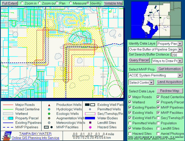
Spatial selecting and spatial overlay are implemented as identify tools applicable on property data layer and wetland layer. User can select and identify features within a search distance, over the buffer of a selected pipeline, over the buffer of a selected pipeline segment, within or over the polygon that user defined interactively on the map. The features selected are highlighted on the map, and a new browser window is opened to display the attribute data of the selected features. Figure 2 presents the results of identifying the property parcel over the buffer of selected pipeline segments.
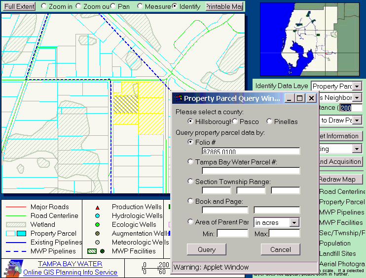
The property parcel data query is implemented through a query interface window that is opened by a click on the query parcel button on the main client interface. There are five different ways to query the property parcel data for each of the three counties served by Tampa Bay Water. The property parcel data can be queried by folio number or parcel ID, by Tampa Bay Water parcel number, by section township range number, by book and page number, or by a user specified range of the parcel areas. Figure 3 shows the property parcel query interface. The query results are displayed as a HTML table in a new browser window, and the map is automatically zoomed to the parcels selected from the query.
User can get information about Master Water Plan projects through the interface. User can select the project from a drop-down list. The map will automatically zoom to the selected project. User can get project information by clicking on the �Get Information� button, and a new browser window will be opened with the latest information about the select Master Water Plan project.
Land acquisition information for contracts related to Master Water Plan projects can be obtained through the interface. A user can select a contract from a drop-down list, the map will automatically zoom to the site of the selected contract. The status of each related property parcel is visualized in different colors, either surveyed, suit package approved, negotiated agreement approved, resolution approved, or available for construction. The attribute data of each related property parcel is returned in a HTML table in a new browser window. A consultant maintains the database. Once the database is updated, the map and attribute data will be updated automatically when user queries the land acquisition information through the application.
Options of color classified property parcel according to its land value or property value are available on the GIS Planning Info Service interface. Property parcel can be drawn as outline, color-coded by land value, or color-coded by property value. A dynamic legend is generated and updated accordingly.
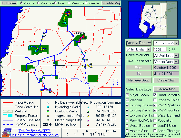
Spatial selecting and spatial overlay are implemented as identify tools applicable on water production data, water level data and rainfall data. Identify tools are developed to select and identify sites / wells within a user specified distance or within the polygon that user defined interactively on the map to get a summary report of water production, water level or rainfall data over a user specified time period.
The summary results, either total, maximum value, average value, or minimum value, of water production data, water level data or rainfall data are visualized on the map by classifying the quantity value into color codes. A dynamic legend is created and updated accordingly. Figure 4 displays the query results of water year to date total water production on June 21, 2001.
Wells/sites selected by spatial tools can also be used as selection to retrieve detail data or create trend line or bar charts. The feature selection can be modified manually, adding or removing features from the selection list on the selecting interface.
An interactive query interface is designed to enable users to query and retrieve the water production and environmental data. Up to 50 sites/wells can be selected to retrieve their detail data in one request. Daily data is available for water production, and daily, hourly and monthly data are available for water level and rainfall data. Users can also specify the time period that the data will be queried and retrieved.
Water production data is organized into different tables for different periods of time. The server program checks the time span user specified and automatically unions the related tables together to get the correct results. Water level data and rainfall data are organized in individual tables for different sites. The server program queries the individual table for each site and put the results together into the report. The server program also checks and lines up the data records according to the time stamps at which the data is collected.
Users can use spatial tools to select sites/wells, or select site/wells from site ID lists grouped by well fields. User can add, add all, remove or remove all sites/wells to or from the sites/wells selection list.
A create-chart wizard is designed to help users create trend line or bar chart from historical water production, water level and rainfall data. Users can select sites/wells and specify data type and time period in the wizard. Title, labels and legends can be added to X, Y-axes and each data series.
Up to five data series can be drawn on the chart, and up to three different data types can be drawn using different Y-axes, as the primary Y-axis, the secondary Y-axis and the third Y-axis, each with different data scale and range.
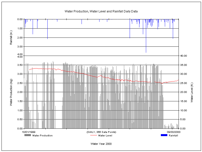
The create-chart function can handle up to ten thousands data points for each data series. The data type can be daily data for water production data, and daily, hourly or monthly data for water level data and rainfall data. The client interface checks the user input and sends the request to the server. The server automatically queries the related database and returns the data results in a HTML interface in which it calls the create-chart applet to generate the chart. Figure 5 is a sample chart of daily data in water year 2000 created for a well at north part of the Cross Bar Ranch well field.
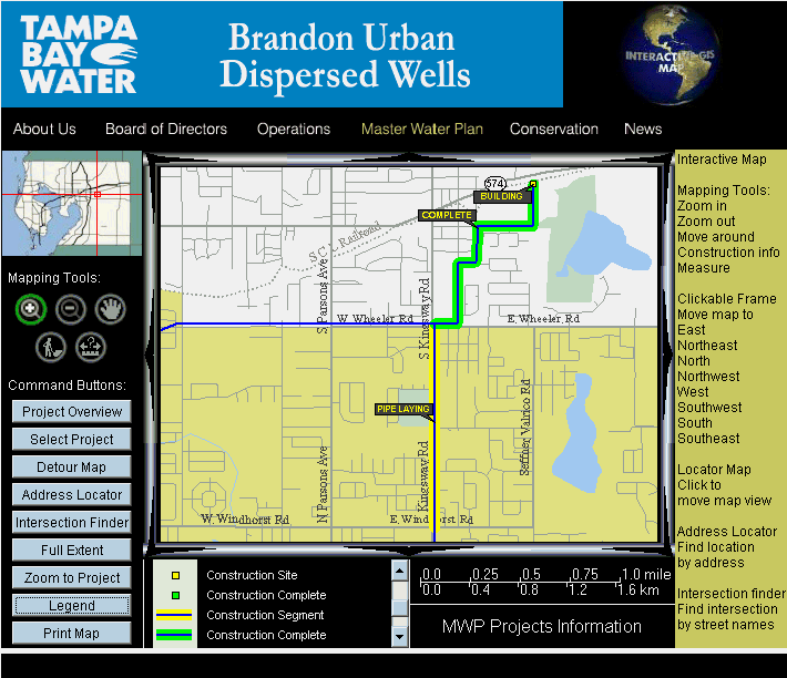
Master Water Plan Project construction information service is an internet web-based GIS application. It is developed with a customizable client interface to provide construction information regarding each Master Water Plan project. There is only one server application running on the server, and each project has a customized client interface for each Master Water Plan project.
Construction Information is one of the most valuable tools for Master Water Plan projects under construction. The information is updated through shapefiles and visualized by color-coding on the map. An interactive tool can be used to get construction information for any segment of any project under construction. A detour map, if applicable, is also available by clicking on the detour map button on the interface. Figure 6 shows the interface and the construction information for the Brandon Urban Dispersed Wells Project.
Address locator and intersection finder interfaces were designed to take user input to locate addresses or intersections. The interface performs data validation by checking input data type and format prior to submitting the request to the server. If an address match failed, an error message would be displayed regarding the level of the failure, city level, street level, or block number range. If it partially failed, a list of possible addresses would be displayed in a combo list, and the user can select any of them to try the address match again.
The ID&M system, a user-oriented web-based GIS system, was developed to provide tools for searching, retrieving, analyzing and mapping water-related information to a wide range of users. Through a user-friendly interface accessible from any computer connected on the network, the application provides many highly customized functionalities including specific spatial analysis, information querying, retrieving data, data summarizing, trend analysis, construction information, address matching, and etc.
This system includes three individual web sites, two intranet GIS services and one Internet GIS service. The GIS Planning Info site provides general spatial information related to Tampa Bay Water existing and proposed facilities. Through database queries or spatial overlays, a user can search and retrieve property related information, wetland, or project-related information. The GIS Environmental Info site provides tools for the user to visualize, retrieve, summarize or analyze historical water-related data gathered over the past 25 years. The Master Water Plan Project Info site provides a quick overview of the selected project, address/intersection locating, latest construction information and detour map if applicable.
While these sites are still under further development, the system has already proven to be invaluable to a staff of hydro-geologists, engineers, operators and public relations personnel. The web-based GIS applications can easily answer questions that staff members face in their daily work while performing complicated information search assignments. This success proves that a user-oriented web-based GIS application that includes user participation from the beginning and throughout development phases is a viable solution to implement GIS into the daily operations of a water utility.
Web-based GIS is getting more and more popular because it is easily accessible and user-friendly, but it is often difficult to integrate into daily operations of a water system due to the large variety of information involved and different functionalities required. Customized functionalities, in addition to the basic mapping and query capabilities a web-based GIS usually provides, are the new challenges to the GIS development community.
The solution to the challenge partially lies on the ability to implement well-balanced client-server architecture to support user requirements and provide with a solid platform for system expansion. The client application handles certain computations and reduces server load, minimizes network communication, and broadens the scope of user interface and application functionalities. With the advancements on GIS technology and Internet infrastructure today, comprehensive client application development will take web-based GIS applications to a new level.
The authors would like to acknowledge and thank the following professionals, Elise Schreiner, Audrey Clarke, Marty Nitzberg, Dave Detwiler and Dave Bracciano, for their participation and help.