
For more information contact:
PR Blackwell, Information Scientist
Forest Resources Institute
Stephen F. Austin State University
PO Box 6109, SFA Station
Nacogdoches TX 75962-6109
prblackwell@sfasu.edu
http://www.fri.sfasu.edu

PR Blackwell, Information Scientist
Susan Henderson, GIS Specialist
Forest Resources Institute
Stephen F. Austin State University
The Texas Geography Network Regional Node Initiative expands on the Texas Geography Network by replicating state geospatial archives in nine regionally located data centers across the state. The Regional Nodes will provide redundant access to StratMap data, as well as, access to local and regional data not covered by the state. Providing a regional point of contact is seen as a way of reducing the demand on the state facilities and expanding the functionality of the Texas Geography Network. Note: This paper is a companion piece with Paper # 637: A Geography Network for Texas.
Global access to data. This is the promise of the Geography Network. But what does it take to really accomplish that goal?
The Geography Network, as envisioned by Esri, and implemented in the Texas Geography Network, is, in the final analysis, a metadata search engine. As such, it provides a vital link in the quest of data. The task of actually delivering those data, however, is left to others. How do we deliver data in the age of SDE and IMS? It’s no longer about magnetic tape or CD-ROMs or even Internet download. The new order is built around client server access. It’s about universal access to data.
The state of Texas is an interesting surrogate for the larger problem of delivering data worldwide. Texas is geographically and culturally diverse. It covers a substantial area, and presents many of the issues inherent in the larger problem. In addition, Texas has invested heavily in developing a comprehensive base map of geospatial data. The Texas Strategic Mapping Program (StratMap) represents an investment of over $40 million in federal, state, local, industrial and private funds through partnerships and cooperative agreements. The challenge of getting these data to users, particularly in rural areas, and in light of the new technologies being developed at Esri and other companies, is overwhelming.
The Texas Natural Resources Information System (TNRIS) is the state agency mandated to coordinate the use of spatial data in Texas. Through cooperation with state and federal agencies, universities, and regional entities, TNRIS coordinates the acquisition, sharing and distribution of geospatial data for Texas. The Texas Strategic Mapping Program (StratMap) is an example of the work being done by TNRIS. StratMap is creating a common base map of high-resolution geospatial data for use by all.
TNRIS has maintained an FTP download site for StratMap and other data for many years. Now, Internet Map Services are being added to the traditional FTP access.
The Texas Geography Network (TxGN) is a TNRIS initiative designed to make spatial data easier to locate and use in Texas. In the broadest sense, TxGN is the joining together of geospatial data providers and geospatial users in a cooperative association dedicated to sharing geospatial data.The program is authorized by the Texas Geography Information Council (TGIC) and sponsored by the TNRIS.
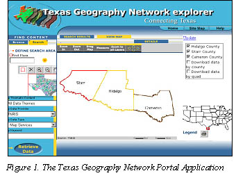
The focal point of TxGN is the TxGN Portal Internet Application (Figure 1). Patterned after Esri’s Geography Network Portal, the TxGN Portal serves data producers and users of Texas. State agencies and other data producers register their data with the TxGN Portal application in Austin. Users log on to the Portal, and use powerful searching capabilities to identify data that meet their requirements. If the data source is an Internet Map Service, the user can preview the data and explore it within the portal application using the Texas Geography Network Explorer. Map service data is spooled through the TxGN Explorer from the hosting site to the client.
The client is also able to select and download data through the Explorer, or connect directly to the hosting site to take full advantage of the service.
TNRIS acts as a central repository and clearinghouse for geospatial data for Texas. As such, TNRIS hosts a great deal of data, including the StratMap data archives. The demand on a single server of geospatial data in a state the size of Texas is enormous. As the new technology develops, demand for client/server access to data archives will quickly overwhelm the capabilities of any single system.
Recently in Texas, this point was recently graphically illustrated. On June 5, 2001, tropical storm Allison came ashore in Southeast Texas. Over the next few days Allison proved to be one of the most damaging storms in Texas History, causing at least 42 deaths and damages estimated at $4 billion. Massive flooding was responsible for most of the damage. One of the facilities flooded held the routers that connect the Stephen F. Austin State University (SFASU) campus network to the Internet.
As a result SFASU and the Forest Resources Institute (FRI) were isolated from the Internet for several days. When FRI was alerted that assistance might be required for damage assessment work associated with tropical storm Allison, FRI was unable to comply, as were most of the facilities capable of such work in the region. In this case, a single point of failure isolated most of the GIS resources in East Texas.
The answer to both these problems: better access to geospatial data and services, and maintaining capability in the face of disaster, can be found in the Texas Geography Network Regional Node (TxGNRN) Initiative.
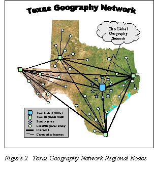
The Texas Geography Network Regional Nodes extend the Texas Geography Network by providing a system of regional data nodes distributed strategically across Texas. These nodes replicate StratMap base map data and host additional data of local and regional interest. Connected by a high-speed network backbone, the nodes provide distributed access to state data archives and regional support for local users.
The Regional Nodes take advantage of the high-speed research network operated by the University Corporation for Advanced Internet Development (UCAID). Internet2 provides the bandwidth necessary to move large datasets around the state quickly.

Internet 2 members participate in two experimental, high-speed networks, vBNS, for very Broad Band Network System, and Abilene, a new high-speed experimental network backbone constructed and managed by UCAID. The TxGN Regional Nodes will use these networks for communication between node and with the central hub at TNRIS, as well as various data providers such as the Center for Space Research (CSR) at the University of Texas in Austin and Eros Data Center (EDC) in Sioux Falls, South Dakota.
In addition to providing high-speed connectivity, UCAID participation in the TxGNRN project provides an opportunity to promote geospatial interest within the Internet 2 community. With this in mind, FRI has initiated a new working group within UCAID -- Internet2: Geospatial or I2:GS. I2:GS will look specifically at geospatial issues within the context of advanced, high-speed networking. This will ensure that new Internet technologies will adequately support geospatial issues in the future.
Several UCAID initiatives are directly applicable to the Texas Geography Network Regional Node project. Work currently being done on distributed databases, large format imaging, and quality of service (QoS) can be applied to help address regional node issues. The connection with Internet2 will allow the Texas Geography Network to benefit from these and other projects already underway by UCAID members.
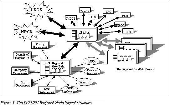
Functionally, TxGN Regional Nodes will act as extensions of TNRIS. TNRIS has associations with many state agencies, as well as connections with national mapping groups, such as the USGS, EDC, and others. Each regional node will develop similar relationships with local and regional data-producing and data-using entities while maintaining connections with TNRIS.
The Regional Node will be a local contact for mapping in each region. All nodes will coordinate with local and regional entities, and with TNRIS to extend statewide mapping programs to the widest possible audience. Each one will also specialize in the issues pertinent to the regions they are located in. Thus, FRI in East Texas will concentrate on forestry issues, while a node in the Texas Panhandle might look at agricultural and/or drought issues.
Because of the Internet2 requirement, each primary node will be a member of UCAID. As UCAID is a corporation of Universities, the primary nodes will be placed on University campuses. Each primary node will:
Each node will be expected to provide access via standard File Transfer Protocol (FTP) and Hyper Text Transfer Protocol (HTTP) download. In addition, the nodes will host Internet Map Services for the StratMap base data for Texas. Initially, the nodes will host only those data pertinent to their region. As the system develops, certain nodes will replicate the StratMap holdings for the entire state, providing single point redundancy for the primary archives in Austin. StratMap base data includes:
Other high-resolution data of general interest will be made available, including seamless USGS Digital Raster Graph (DRG) data (digital 7.5 m quad sheets), US Census data, and others.
Selected satellite imagery will be made available through the node system. Notably, the North American Land Classification (NALC) data developed by the National Aeronautics and Space Administration (NASA) and the Environmental Protection Agency (EPA) will be available for the entire State. This dataset is comprised of three decades of Landsat 5 data, 1974, 1986, and 1992, and provides an invaluable resource for land change and other studies. Complete, recurring, Landsat 7 ETM+ coverage for the state will also be made available. Other satellite imagery will be added to the archives as funding and licensing can be arranged.
One of the important functions of the regional nodes will be to serve datasets of regional interest that are not available through the state archives. In this way, local and regional agencies lacking the resources to deploy their own servers can negotiate with the node for assistance. This will have a tremendous impact, particularly in rural areas, by making a wealth of data available to the public that would otherwise be inaccessible.
Each of the nodes will be expected to provide technical support and training for local users. Experience at TNRIS indicates that assisting data users is a necessary and important part of the task of distributing geospatial data. By distributing support through the node system, pressure on TNRIS staff will be alleviated allowing more concentration of new data acquisition, quality control and so on.
In addition, a regional entity is better equipped to meet the needs of local users. In rural areas in particular, having local support will make the use of geospatial technology practical for many agencies and individuals not currently able to take advantage of it. Making basic geospatial training available will allow many more individuals to participate as well. A half day seminar just down the road is much more palatable than a trip to Houston, Austin or Dallas, given the work loads and budgetary constraints common in rural agencies.
Much of the success of the StratMap program has been due to cooperative agreements and cost-sharing arrangements with various governmental agencies, industry and other groups. The regional nodes will help coordinate these kind of cooperative agreements within their region for future data acquisition.
The nodes will also act as clearinghouses for updates and new data. Once accepted by the node, new data will be forwarded to TNRIS for final QA/QC and acceptance into the state archive. This procedure will streamline the data acquisition process by distributing the workload around the state.
As the program matures, nodes will deploy targeted geospatial applications via the Internet to address specific local needs. These applications can be customized for each node’s clientele and will be implemented using server-side technology, minimizing the computing requirements for the client.
Targeted Internet applications can bridge the gap between geospatial technology and the users. Focusing on specific needs and concentrating computing resources on the server minimizes requirements for the end user. IMS technology from Esri enables this kind of targeted application to be developed relatively easily. The result will be a new class of geospatial application that brings the power of GIS to a greater audience than ever before.
Finally, each node will be part of a statewide geospatial emergency response network. The combined response of all the nodes will be much more effective than could any one facility. Redundant data, facilities, and personnel will eliminate the kind of single point failure that crippled the southeast Texas GIS community during tropical storm Allison.
Communications and data flow will be enhanced as well. The closest node to the site of the emergency will coordinate with local emergency personnel while TNRIS in Austin coordinates with the Department of Emergency Management (DEM) and the other nodes.
This model for GIS Disaster Response is very powerful and readily applicable to other areas. A national system of nodes would provide similar benefits for truly large-scale emergency situations.
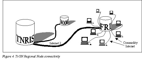
The functionality of the regional nodes can be considered in two steps: node-to-node and node-to-user.
First, node-to-node and node-to-hub connections will be via the I2 experimental networks. By making I2 connectivity a node requirement, high-speed communications between all hubs is ensured. This will allow rapid movement of data between the nodes for updating data sets, delivering new data, and responding to local needs during emergencies.
Secondly, local and regional access to the nodes will be via commodity Internet. Using state-of-the-art web serving and Internet mapping technology, the nodes will deliver data directly to the public desktop. FTP and HTTP protocols and server-side technology will be used to minimize requirements for the end user.
The lack of high-capacity Internet bandwidth is a major obstacle for node to users communications at this time. Commonly available dialup access will not support the requirements of client/server access to geospatial data. Even FTP download capabilities are challenged by available dialup bandwidths.
These problems are being addressed through the I2:GS initiative. Until a resolution is available, however, several steps are being taken to reduce bandwidth requirements for the end user.
For example, providing access to image data for dial-up users is of primary concern. For now, image datasets such as DOQQ and Landsat imagery will be made available in MrSID compression format. At 20:1 compression, MrSID reduces a standard 150Mb 1-meter DOQQ to approximately 8Mb, making it more feasible for download via dial-up connection.
Some of the new technology being developed by Esri will help ease the connection requirements for users as well. SDE allows large, seamless datasets to be served in user-defined chunks. This makes it possible to offer large extents of seamless data while downloading only the portion needed. Scale-dependent rendering is another technique that can reduce the bandwidth requirements for the end user.
Even with these and other techniques, bandwidth remains a problem for end-user connectivity. Part of the Regional Node Initiative includes bringing high-speed networking to rural agencies, schools and libraries through the Telecommunications Infrastructure Fund (TIF) and other funding opportunities. Limitations imposed by Internet bandwidth will diminish over time. At present, however, bandwidth remains a major concern.
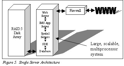
Two basic approaches can be taken toward hardware architecture for the regional node project. The first calls for a single, powerful server running all layers of the software protocol. This approach has the advantage of design and operational simplicity, as well as robustness. The disadvantages include initial costs and lack of redundancy (Figure5).
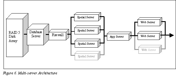
The other approach is based on multiple, redundant servers. This model separates software function on an array of independent servers. It offers the advantages of scalability and redundancy, as additional servers can be added as required (Figure 6).
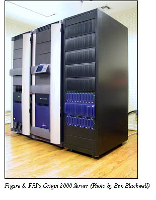
FRI has selected a hybrid of these two architecture models for the TxGNRN prototype node. This decision was made to take advantage of existing equipment and to integrate the prototype node into other research and database activities at FRI. In addition, beta and first release versions of pertinent software were not available on existing hardware platforms. The FRI model is designed around a Silicon Graphics Origin 2000 server. The Origin is an ideal choice for the single server model because of its power and scalability. SGI’s implementation of UNIX (IRIX) is an extremely robust and mature operating system. Unfortunately, neither is popular enough to be considered for early releases of new software. In this case, Esri’s 8.1 release of ArcSDE for IRIX is still under development as is the 3.1 release of ArcIMS. Fortunately, Esri’s software architecture is flexible enough to work around these difficulties.
The prototype design combines both server models by incorporating a single large-scale server for database and SDE functions, and adding multiple redundant NT computers as spatial and web servers (Figure 7). This approach provides many of the advantages of both models while permitting the use of existing resources. As software becomes available for IRIX, more functionality may be shifted to the Origin. Rigorous analysis as resources are shifted will reveal the best balance for maximum performance and reliability.
Obviously, this is a complex and sophisticated environment and is far from inexpensive. The clustered servers on the front-end allow for maximum redundancy and scalability where the system is most vulnerable. This also allows protection of data archives by inserting a firewall between the front-end servers and the database server.
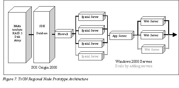
The TxGN Regional Node prototype is built on Esri ArcGIS software. Data is stored in an Informix database using ArcSDE 8.1. Access for internal use and for use by SFA's GIS laboratories is via direct connect to SDE. Because ArcSDE 8.1 is not yet available for the IRIX operating system, the prototype employs a Windows 2000 server to host the SDE instance. An ODBC connection is used to access an Informix database running under IRIX on the Origin. This arrangement, though seemingly convoluted, is working acceptably. When ArcSDE is ported to IRIX, the current Windows SDE server will be redeployed as a spatial server.
The ArcIMS 3.1 architecture is similarly modular. This allows multiple servers to be utilized to increase performance and redundancy. For the prototype, at least in the initial stages, multiple Windows 2000 servers will be used as IMS spatial servers. External access to data will be through IMS.
Regional Nodes will provide access to geospatial data in several ways. For users internal to Stephen F. Austin State University, direct access to SDE will be available. This will provide maximum performance and flexibility for researchers and students on campus.
Users located outside of the University will have a variety of options for accessing data. Standard download via FTP and HTTP will be available for those that require this type of access. This is the traditional method of distributing spatial and other data over the Internet and the regional nodes will fully support it through command-line FTP or HTTP (Web) interfaces.
Internet Map Services will be offered in two forms. First, data services will be provided for individuals using IMS-aware client software such as ArcGIS 8.1. These map services will be designed with relatively simple datasets to facilitate the client/server access.
The second class of Internet Map Service to be offered by the prototype node will be targeted applications as described earlier. The first of these applications will be a generic mapping program that allows users to locate property, delineate features, and print a simple map.
Because these applications run on the server, no special hardware or software is needed by the client. Because the applications are sharply focused, no special GIS expertise is expected of the users. This type of application will bring the power of GIS to more people than ever before.
FRI is committed to building the prototype Regional Node for the Texas Geography Network and to demonstrating its effectiveness. Both FRI and Stephen F. Austin State University have made substantial investments in hardware, software, facilities and development hours. Phase one of the prototype node deployment is nearing completion. Datasets are on line for the East Texas regions (defined for these purposes as the section of Texas falling in UTM Zone 15). Work is continuing towards establishing Internet Maps Services for these data.
 Cooperating fully with TNRIS, FRI will expand the prototype node to include data for all
of Texas. At the same time, efforts are underway to identify and secure funding for additional
nodes. The initiative is gaining momentum in Texas. Public agencies, politicians
and individuals have endorsed it. This past Texas state legislative session, a bill was
introduced that would have funded eight core nodes across Texas. Unfortunately, the bill
did not pass. Still, the legislative initiative brought the project considerable visibility.
Cooperating fully with TNRIS, FRI will expand the prototype node to include data for all
of Texas. At the same time, efforts are underway to identify and secure funding for additional
nodes. The initiative is gaining momentum in Texas. Public agencies, politicians
and individuals have endorsed it. This past Texas state legislative session, a bill was
introduced that would have funded eight core nodes across Texas. Unfortunately, the bill
did not pass. Still, the legislative initiative brought the project considerable visibility.
The Texas Geography Network Regional Node Initiative has received widespread support. It will go a long way toward solving many of the problems that challenge Texas today, particularly in rural areas. But in a larger sense, the TxGN Regional Node initiative represents a model for distributing spatial data that can be replicated around the nation and the world. It is truly an idea whose time has come.
For more information contact:
PR Blackwell, Information Scientist
Forest Resources Institute
Stephen F. Austin State University
PO Box 6109, SFA Station
Nacogdoches TX 75962-6109
prblackwell@sfasu.edu
http://www.fri.sfasu.edu