Managing aircraft inventories at United States Air Force installations is often performed manually and/or with multiple electronic applications. Through the use of Environmental Systems Research Institute, Inc. (Esri®) MapObjects® and ArcIMS® technologies, aircraft management at Robins Air Force Base (AFB) has been streamlined and integrated. The Flight Line Management System (FLMS) was developed by Earth Tech, Inc. to automate and allow shared access to aircraft management information. Aircraft inventories are managed through an easy-to-use, custom Microsoft® Visual Basic® application and projected on a large-format display in an aircraft control room. Read-only spatial information is then made available to users throughout Robins AFB with ArcIMS software. The result is an efficient, cost-effective solution using spatial process automation and distributed information sharing.
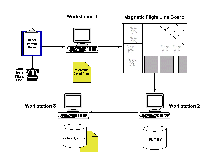
Robins AFB Maintenance Operations Center personnel are responsible for tracking Maintenance Depot aircraft movements. Prior to the development of the FLMS, Maintenance Operations Center personnel used a variety of systems to track and record aircraft movements including handwritten notes, electronic spreadsheets, magnetic wall maps, proprietary relational databases, among other systems. The previous aircraft tracking process started with hand recording all aircraft movements, as reported from the Flight Line, on clipboards. This information was then entered into a Microsoft Excel spreadsheet file. Concurrently, aircraft locations were placed on the wall-sized magnetic Flight Line Board in the Maintenance Operations Center control room, using small magnets. At certain times, the data residing in the Excel spreadsheets were migrated into a proprietary database called the Program Depot Maintenance Scheduling System (PDMSS).
Challenges with the previous aircraft tracking method were numerous. With the majority of the aircraft data being tracked manually, there was significant data redundancy (i.e. handwritten notes, Microsoft Excel files, PDMSS repository, magnetic board, etc). This system was inefficient, and increased the likelihood of erroneous data entry. Due to the lack of standards and the use of various naming conventions between the different systems, Maintenance Operations Center personnel found data correlation difficult, resulting in delays in producing reports quickly (e.g. for auditing).
In response to the issues discussed above, Robins AFB requested that Earth Tech develop an automated process for tracking aircraft maintenance movement information. A phased application development was deemed to be the best approach: collecting proper user/developer feedback, incorporating latest software technology, and allowing funding source identification.
The first step in developing the FLMS was to investigate and model the existing Maintenance Operations Center aircraft tracking processes and determine the functional requirements of the proposed automated system. This provided conceptual design specifications for the application. After several meetings with Robins AFB personnel, the process flow of the Maintenance Control Center was modelled and diagrammed. Figure 1 shows the historic FLMS process flow
Detailed requirements for spatial data capture and potential attributes for aircraft parking locations were developed. The parking locations were surveyed and captured in the field along with attributes (Tie Downs, Fire Safety, Hangar, Location, Checkpoints and Fuel Repair Station). This field data was captured and initially stored as MicroStation® design files (DGN), and subsequently translated into Esri shapefiles.
Once the conceptual design specifications were finalized and spatial data-capture was completed, Earth Tech researched potential technologies to meet the project objectives, including computer hardware, software and networking requirements. The prototype FLMS application was required to be user-friendly, provide spatial information about aircraft locations, and interface with outside systems via Open Database Connectivity (ODBC) protocols.
MapObjects, software developed by Esri, was selected for viewing static data and updating dynamic data. MapObjects development components were incorporated into the resulting application using Visual Basic 6.0 Enterprise Edition as the development environment. Underlying spatial data were stored in a combination of shapefiles and DGN files. The Microsoft Jet (Access) database engine was used to store historical, ephemeral and static data to drive the application. Earth Tech developed functional design specifications internally with feedback from Maintenance Operations Center personnel.
The prototype needed to simulate a connection to the PDMSS data repository in anticipation of connecting to the production repository when the final FLMS application was implemented. Representatives from the PDMSS group played an integral part in determining tables to be accessed and fields to be updated by the FLMS application via ODBC. The consequences of updating data collected by the FLMS application into the PDMSS repository, such as cascading interface triggers and database triggers, were taken into account.
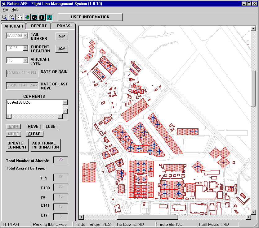
The majority of the FLMS application's functionality is accessed by the end-user in three tabs on the user-interface: AIRCRAFT, REPORT, and PDMSS. The process flow of tracking aircraft has been fully automated with three command buttons - GAIN, MOVE, and LOSE - located on the AIRCRAFT tab. MapObjects map controls were incorporated into the application in order to display dynamic aircraft locations and static Flight Line spatial data. The FLMS application uses DGN files for each major aircraft type (e.g. C130, F15, etc.) maintained at Robins AFB. These DGN files were drawn to scale and representative shape. Aircraft positions were represented visually by DGN files, but were driven by a dynamic shapefile. Shapefiles were used to depict static spatial data such as building outlines, parking locations, runways, and roads. An important component of the FLMS application was synchronization of dynamic aircraft shapefiles and FLMS database records.
The FLMS application has the ability to generate ad-hoc reports based upon multiple user-specific criteria. A query may be based on a PDMSS project number, tail number, or date. The functionality for the interface between the FLMS application and the PDMSS repository is located on the PDMSS tab. It is here that the user can generate a list of records that require uploading into the PDMSS repository, verify that a connection exists between the FLMS application and the PDMSS data repository, and manually update new transactions for the day. For the prototype, connectivity between the FLMS application and the PDMSS is simulated by a connection to an Access database.
Following the initial phase of application development, Earth Tech commenced internal Alpha testing of the FLMS application. During this phase, FLMS basic functionality was assessed for ability to meet both conceptual and functional requirements. Beta development of the FLMS followed. Final implementation and training of the prototype FLMS application were completed in early April 2000.
The next phase of FLMS development focused on production rollout of the system, Version 1.0. This version of FLMS application included further testing of the prototype application, bug reporting, and incorporation of enhancements requested by Maintenance Operations Center personnel. Early on in the application development, test plans were written. Under this phase, additional spatial updates were made to Flight Line spatial data, to reflect modifications to aircraft parking configurations. Figure 2 shows the user interface of the FLMS version 1.0.10 application.
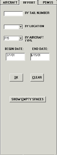
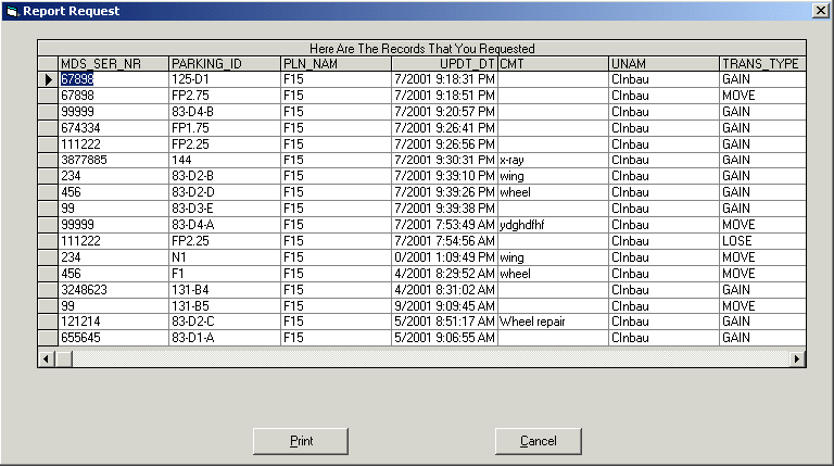
Version 1.0 modifications included additional tools for recalling aircraft and parking space information. Counters were added to display the total number of aircraft on the Flight Line and aircraft totals by type - providing instant reporting capabilities and increasing data readily available for auditing purposes. New buttons were added to update comments, and an Additional Information matrix was incorporated. This Additional Information matrix replaced the functionality that was previously entered by another process that used Microsoft Excel, providing Robins AFB personnel with a more streamlined process. Under the REPORT Tab a more versatile calendar component was added to enhance date query capabilities. Figure 3 shows the REPORT Tab, and Figure 4 provides an example of a sample report.
Early in FLMS development, a major functional requirement was connecting the application to the PDMSS repository and updating information as required. It was assumed that the FLMS application would be able to write to the PDMSS repository via the OpenRDA ODBC driver; however it was later determined that the driver would not allow writing to the proprietary PDMSS database. Fortunately, the vast majority of the FLMS-PDMSS integration code was developed with portability in mind, in anticipation of the PDMSS repository being migrated to an OracleTM database in the future. Most existing PDMSS interface code can be used, and costs/efforts will not be lost. Robins AFB is schedule to migrate the PDMSS to Oracle in the next fiscal year.
The installation of Version 1.0.10 of the FLMS was completed November 2000.
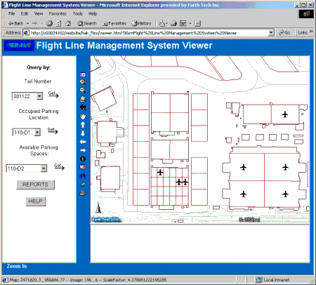
ArcIMS software, developed by Esri, was selected for the prototype web-based viewing tool. Requirements for the Web-based FLMS application included designing a map view, queries for airplane and parking space, and report generation. This application is designed for managers, providing them with a set of easy-to-use, web-based tools to view and query the FLMS database in real-time.
The Web-based FLMS application was developed with the ArcIMS 3.0 HTML Viewer, and used Microsoft Active Server Pages (ASP) for database connectivity. A Microsoft Internet Information Server (IIS) 5.0 web server, the Robins AFB standard web server, was used with ServletExecTM 3.0, a product of New Atlanta Communications, LCC., as the servlet engine.
The interface is frame-based and includes the map display, tool bar, the text display, and an ASP frame for database query input. The figure below provides an illustration of the prototype Web-based FLMS application. The ASP component provides tools in which the user can construct complex SQL queries to the FLMS database, returning HTML formatted reports.
Key challenges in developing the IMS application included "locking" of shapefiles that the FLMS application interacted with, and the inability of the software to read DGN files. Shapefile locking was an issue for the dynamic nature of the aircraft positions. As discussed above, the FLMS application was the driver of the database and the aircraft shapefile generation/modification; integration between the FLMS database and the dynamic aircraft shapefile is a critical component of the FLMS. However, once ArcIMS software placed a "lock" on the aircraft shapefile, the FLMS database was out of sync, and the FLMS application crashed, causing database corruption. To solve the problem, ArcSDE for Coverages software was used to prevent ArcIMS software from locking the shapefiles. In the future phase, ArcIMS 3.1 software will be used, which does not "lock" shapefiles. Utilizing TrueType fonts of aircrafts solved the problem of ArcIMS software not rendering the DGN files of the aircraft types. The prototype used only one TrueType font for all aircraft types; however, future application enhancements will use different fonts for each aircraft type and place these to scale.
Proposed future development and enhancements are expected to start in mid-2001. Future FLMS work will include additional enhancements, developing and implementing the Web-based FLMS, updating the FLMS for integration with the Oracle system, and developing a pilot FLMS integration with the Facilities Equipment Management System (FEMS).
The FLMS has streamlined and automated much of the aircraft maintenance tracking process at Robins AFB. MapObjects and ArcIMS technologies have provided easy-to-use graphical user interfaces and allowed shared access to aircraft management information by Maintenance Operations Center and Base personnel. Data input and storage redundancies have been reduced with the new system. The result is an efficient, cost-effective solution through spatial process automation and distributed information sharing.