Using GIS in Source Water Assessments
Hampton Roads Source Water Assessment Program
J. Wesley Kleene, Ph.D., P.E., CH2M HILL
Scott Emry, P.G., Hampton Roads Planning District Commission
Linda Warren, P.E., CH2M HILL
Abstract
A comprehensive data management system was developed to support the spatial analysis between potential sources of contamination known as "Land Use Activities (LUAs)" and the drinking water intakes for the eight surface water utility members of the Hampton Roads Planning District Commission (HRPDC). This analysis provided a comprehensive overview of the landuse activities (LUAs) and the landuse patterns within each watershed. The basic approach is defined here with example results to support the Source Water Assessment Reports to be delivered to Virginia Department of Health.
A query-based system was developed and distributed to the stakeholders to support local watershed managers and utilities. The system requirements ultimately included the hardware and software limitations of individual stakeholders and jurisdictions. Therefore, the lowest denominator for delivery was a database (Access) with data linked to GIS layers for viewing in ArcView or ArcExplorer. The logical next phase of the project would migrate the data to an enterprise application using ArcIMS technology.
Introduction
The Hampton Roads Source Water Assessment Program (HRSWAP) was conducted for the Hampton Roads Planning District Commission (HRPDC) Source Water Assessment Program (SWAP) Subcommittee. This cooperation of member local governments established the HRSWAP to promote watershed protection and to fulfill the technical requirements of the Virginia Department of Health (VDH) Source Water Assessment Program (October 15, 1999) for surface water systems and conjunctive use wells. Each utility (or jurisdiction) may contain multiple intakes and associated contributing areas defined as watersheds or buffers surrounding the conjunctive use wells.
Geographic Information Systems and relational database management systems were developed to provide analysis and reporting for the project. In addition to a primary data management tool, these systems were used to provide stakeholders (personnel supporting the water utilities, watersheds, and local jurisdictions) access to the data on a routine basis. Spatial and non-spatial reporting systems were developed to allow the user to query the database, and generate spatial data for viewing or further analysis. Requirements for this system evolved over the life-cycle of the project to include data management (including record updates), generation of spatial files, reports, and data export functions.
Data Management System
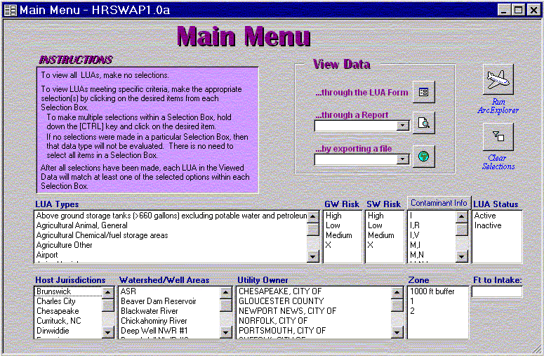
A data management and query system was developed to provide the stakeholders and jurisdiction managers access to the landuse activities data. The GIS was used to process the LUAs and associate them with specific watersheds, intakes, well areas, assessment zones, and jurisdictions. The processed data were also stored in the database (along with coordinate data) to allow for query selections and analysis of the potential risk to surface and groundwater. The data management system was an integrated Access application as shown in Figure 1.

Figure 1. HRSWAP Data Management System
Queries to this system result in specific landuse activity data that will support source water assessments, planning and modeling efforts. The basic view for the landuse activities data is presented in Figure 2.
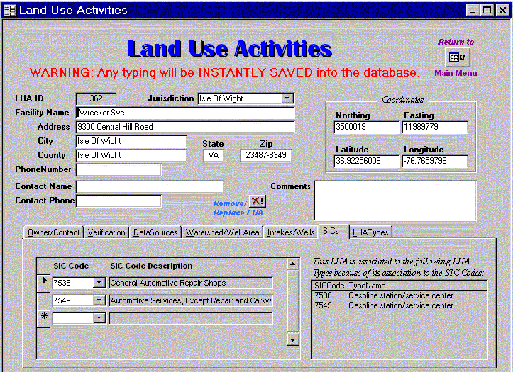
Figure 2. Landuse Activities Information
As noted in the Figure 1 Main Menu, the user can generate a shape file and launch ArcExplorer directly from the Access application. When the shape file is combined with the set of base data layers, the user can readily generate source water assessment maps as shown in Figure 3.
Ultimately, the user can identify areas of interest within ArcExplorer (or other GIS applications) and evaluate the potential impact from the landuse activities within the watershed. The GIS provides a tool for viewing the proximity of landuse activities to other layers such as intakes, roads, and hydrography.
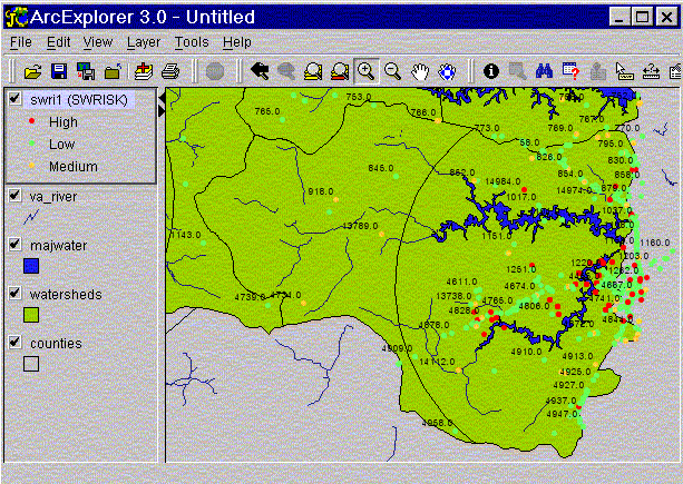
Figure 3. Watershed Map from HRSWAP System
Data Sources and Conversion
Watersheds and assessment areas were delineated on U. S. Geological Survey (USGS) Digital Raster Graphics (DRGs). LUAs were obtained from data sources ranging from federal, state, and local databases to commercially available databases. Local jurisdictions and system stakeholders contributed various levels of data in either electronic or hardcopy format. Once obtained, these data files were clipped to the general study area prior to analysis and processing.
Key coverages developed for this project included watersheds, landuse, LUAs, and intakes (surface and groundwater). General information for these data sources include:
Source Water Assessment Area Delineation
Multiple data sources were combined to generate a comprehensive HRPDC database to link the landuse activities to the water intakes. Spatial data were developed using a variety of methods (digitizing, data file conversion, and spatial modeling). Each jurisdiction (or utility) can contain multiple watersheds and well areas and provided data in different methods/formats.
Once intake locations were obtained and verified, the watersheds of the surface water sources were delineated from USGS Topographic Quadrangle Maps. The boundaries of the watershed were delineated based on topography, hydrology, and transportation information. Where applicable, boundaries of the watershed were delineated by hand until they merged with a boundary already established by the USGS Hydrologic Unit Codes (HUC– 11 digits) or the Virginia Department of Conservation and Recreation (DCR) Hydrologic Sub-Unit Codes (HUC- 14 digits).
The source water zones were defined by the VDH Source Water Assessment Program Guidance (October 15, 1999). For a non-tidally influenced assessment area, Zone 1 is defined as the watershed upgradient of an intake bounded by a 5-mile radius, and Zone 2 is defined as the remaining watershed outside of the 5-mile radius.
The ground water source assessment area, as defined by VDH, is also divided into two zones centered around the groundwater well. Zone 1 is defined as a circle with a 1000 ft fixed radius and Zone 2 is defined as a circle with a 1 mile fixed radius. Additional tools that support travel time calculations from a point source to the well have also been developed, but were not required on this project.
Table 2 summarizes a typical watershed area and source water assessment zones as depicted in Figure 4.
|
Table 1 |
|||
|
Example Source Water Assessment Area Summary |
|||
|
Intake Watershed or Well Assessment Area |
Area Zone 1 (acres) |
Area Zone 2 (acres) |
Total Watershed or Well Assessment Area (acres) |
|
Lake 1 |
8,628 |
N/A1 |
8,628 |
|
WB Reservoir |
13,612 |
28,217 |
41,829 |
|
River Watershed |
16,231 |
993,452 |
1,009,683 |
|
Well #1 |
72 |
1,939 |
2,011 |
|
Well #4 |
72 |
1,939 |
2,011 |
|
1 Note: No part of the intake watershed is greater than five miles from the intake/dam, so there is no Zone 2. |
|||
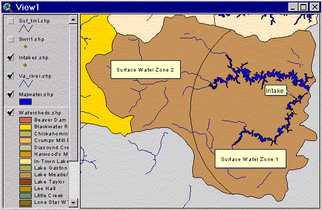
Figure 4. Watershed Zone Delineation
Land Use Classification
Land use classification within the source water assessment areas was obtained from a number of sources. Land use coverages for each jurisdictions were created from a variety of sources. These ranged from Multi-Resolution Land Classification (MRLC) Consortium (Version 05-27-99 with 2000-04 edits), cadastrel mapping, county landuse files, county parcel GIS coverages and associated zoning data. Copies of the land use maps were provided to the local stakeholders for comment. Stakeholder comments were reviewed and incorporated for the development of the final landuse data. Landuse coverages from all the local jurisdictions were evaluated and an attribute mapping methodology created to generate a single HRSWAP landuse coverage. For example, "Residential housing" from jurisdiction A, and "Residential-medium density" from Jurisdiction B were mapped to a single "Residential" attribute in the ultimate HRSWAP landuse coverage.
The GIS was used to generate report summaries of the source water assessment area land use (Example shown in Table 3). These summaries supported a descriptive evaluation of the watersheds for stakeholders and technical staff.
The source MRLC raster data were converted to ARC/INFO GRID format, and then converted to ARC/INFO coverage format. The original NLCD Land Cover Classification System codes were then reclassified according to the uniform land use scheme for HRSWAP, as shown in Table 2. The final data were projected from the original, Albers Conical Equal Area, NAD83, meters, to Virginia State Plane South, NAD83, feet to conform to the project spatial data projection standards.
|
Table 2 |
|||
|
Example of Land Use Summary |
|||
|
Land Use Description |
Area Zone 1 (acres) |
Area Zone 2 (acres) |
Total Watershed Area (acres) |
|
Agriculture: Cropland |
1,955 |
319 |
2,274 |
|
Agriculture: Pasture |
2,882 |
1,968 |
4,850 |
|
Commercial |
46 |
14 |
60 |
|
Forest |
3,169 |
2,804 |
5,973 |
|
Institutional |
31 |
0 |
31 |
|
Light Industrial |
11 |
71 |
82 |
|
Municipal Parks |
4 |
7 |
11 |
|
Single-Family Residential: High Density |
84 |
6 |
90 |
|
Single-Family Residential: Low Density |
887 |
892 |
1,779 |
|
Single-Family Residential: Medium Density |
115 |
0 |
115 |
|
Swamp/Marsh |
748 |
1,881 |
2,629 |
|
Vacant |
5 |
155 |
160 |
|
Water |
948 |
49 |
997 |
|
Total |
10,885 |
8,166 |
19,051 |
|
Table 3 |
||||||
|
Example of Land Use Conversion Table |
||||||
|
HRSWAP Land Use |
City A Landuse |
City B Landuse |
MRLC1 |
|||
|
Land Use Codes |
Description |
Land Use |
Land Use Codes |
Description |
Land Use Codes |
Landuse |
|
HR_SFLD |
Single-Family Residential – Low Density |
|
|
|
21 |
Low Intensity Residential |
|
HR_SFMD |
Single-Family Residential – Medium Density |
Single-Family Residential |
11 |
Single-Family or Duplex |
|
|
|
HR_SFHD |
Single-Family Residential – High Density |
High-Density Residential |
12 |
Town House |
22 |
High Intensity Residential |
|
HR_MF |
Multi-Family Residential |
Multi-Family Residential |
13 |
Multi-Family |
|
|
|
HR_OFF |
Office |
|
22 |
Office |
|
|
|
HR_COMM |
Commercial |
Commercial |
21 |
Commercial |
|
|
|
HR_LIND |
Light Industrial |
Industrial |
31 |
Industrial |
23 |
Commercial /Industrial/ Transportation |
|
HR_INST |
Institutional |
Institutional/ Educational |
41 |
Public/Semipublic |
|
|
|
HR_PARK |
Municipal Parks |
Recreational |
54 |
Park |
85 |
Urban/ Recreational Grasses |
|
HR_HWAY |
Roads |
|
61 |
Street Network |
|
|
|
HR_MIL |
Military/Federal |
|
42 |
Military Base |
|
|
|
HR_FOR |
Forest |
|
57 |
Forest |
41 |
Deciduous Forest |
|
1. MRLC NLCD Land Cover Classification System Key Rev. July 20, 1999 |
||||||
Ranking and Susceptibility
Once the data layers were combined, the data were used to assess the relative ranking of LUAs within an area, based on the risk of contamination each LUA posed to the water source. The data management system produced reports ranking the landuse activities based on their landuse type, risk to surface or groundwater (based on risks assigned to the landuse type by VDH) and distance to intake. Therefore, within each study area, those LUAs with a "high" surface water risk are ranked based on their linear distance to the intake. While further analysis of this ranking could include more refined distance and potential pathway alternatives, VDH has requested this approach to provide consistent methodologies across statewide studies. Table 4 shows LUAs with a relative ranking and proximity to the intake.
|
Table 4 |
|||||
|
Prioritized Ranking of Landuse Activities |
|||||
|
HRSWAP ID |
LUA Type (1) |
SW Risk (2) |
Distance to Intake/Well (ft) |
Facility Name |
Facility Address |
|
18005 |
Tire Pile |
High |
2117 |
Joe's Salvage Yard |
1704 Running Road Gloucester VA 23061 |
|
14665 |
Marina (surface only) |
Medium |
4547 |
Beaver Run Park |
28687 Roaring Springs Road Gloucester VA 23061-4248 |
|
18809 |
Truck terminals |
Medium |
16382 |
Mobile Home Movers |
37022 Old Cabin Lane Gloucester VA 23061-2825 |
|
12359 |
Agricultural Animal, General |
Medium |
18314 |
Bunker Creek Veterinary |
7475 Farys Mill Road Gloucester VA 23061-2924 |
|
15030 |
Construction, Contractor Other |
Low |
11009 |
Black’s Chimney Sweep |
7239 Farys Mill Road Gloucester VA 23061-2913 |
|
15143 |
Construction, Contractor Other |
Low |
11863 |
Wiley's Roofing Svc |
9881 Indian Creek Trail Gloucester VA 23061-5216 |
|
15312 |
Construction, Contractor Other |
Low |
17524 |
Season-All Insulation |
19941 Forest Grove Drive Gloucester VA 23061-2922 |
|
20638 |
Construction, Contractor Other |
Low |
18888 |
Anderson Plumbing |
12562 Lake View Drive Gloucester VA 23061-2835 |
|
Total LUAs In Each Risk Category: |
Low |
Medium |
High |
||
|
Zone 1 |
4 |
3 |
1 |
||
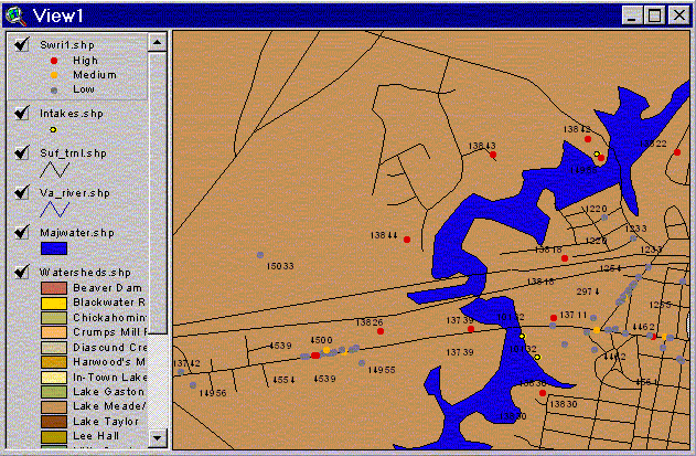
Figure 5. Potential Surface Water Risk from LUAs
Conclusions
A well-designed functional data management plan is essential in the development of a source water assessment program. For the HRSWAP, needs of the stakeholders and utilities were assessed prior to the system design and data requirements. The use of GIS and data query tools enhanced the source water assessment. In addition, a data management and query tool was developed and deployed to support a wide range of user technology levels. The system provided users at all levels access to the LUA data, and was linked directly to a spatial display/analysis tool.
The data management platform provided spatial and non-spatial analysis to generate reports, view analytical results, and provide images for data dissemination. The use of GIS provided a unique mechanism to support the stakeholders and the need to disseminate the data to the public at large. Ultimately, this system can be migrated to a platform that will facilitate internet access to the current data management system.
Acknowledgements
The authors wish to acknowledge the following individuals and organizations:
References
Virginia Department of Health's Virginia Source Water Assessment Program Guidelines, Virginia Department of Health, October, 1999 (http://www.vdh.state.va.us/).
Author Information
J. Wesley Kleene, Ph.D., P.E.
Information Solutions Lead
CH2M HILL
13921 Park Center Road, Ste. 600
Herndon, VA 20171
703.471.6405 ext. 4134
703.471.1508 (fax)
wkleene@ch2m.com
Scott Emry, P.G
Project Manager
Hampton Roads Planning District Commission
723 Woodlake Drive
Chesapeake, VA 23320
757.420.8300
757.523.4882 (fax)
semry@hrpdc.org
Linda P. Warren, P.E.
Project Engineer
CH2M HILL
11818 Rock Landing Drive, Ste. 200
Newport News, VA 23606
757.873.1442 ext. 12
757.873.7657 (fax)
lwarren@ch2m.com