Canadian Municipal Governments such as the City of Calgary are challenged with providing a multitude of services to the citizens they serve. Collecting, managing and sharing the necessary information - both spatial and attribute - to provide these services effectively and efficiently is fundamental to the successful operation of that organization. The current technologies available for spatial information management provide viable and cost-effective alternatives in providing the most appropriate information within a spatial context to the business areas; however, it is also critical for the organization to provide a suitable process model to ensure complex issues of stewardship, data sharing, communication, access, and the like, are in place.
This paper will discuss the development of a Spatial Information Management Process Infrastructure currently under development at the City of Calgary. Emphasis will be placed on the following topics: creating an evaluation methodology for determining Corporate spatial information requirements, categorizing various types of spatial information used at the City of Calgary, evaluating and applying the most appropriate spatial information collection and manipulation methodologies, and managing these information assets within a Municipal environment. Discussion of the Process Infrastructure will be placed in a strategic enterprise governance and operation perspective. Finally, the Process Infrastructure will be verified through specific examples of spatial features required and shared by many separate business areas.
The City of Calgary is experiencing many of the same challenges as any other large organization attempting to efficiently manage both spatial and tabular information given the multitude of information technology (IT) solutions currently available. "Enterprise," or corporately shared technologies, such as GIS, are currently being implemented at the City of Calgary to gain operational and budget efficiencies. These efficiencies are achieved by rationalizing the number of technologies performing similar or identical functions, while at the same time maximizing the utility of the information in as many business units as possible.
Adopting and implementing enterprise technology solutions provides many potential advantages for an organization. However, realizing those advantages requires appropriate information management processes and infrastructures to be developed to ensure that the full corporate requirements for information can be accommodated.
New technology opportunities (like the Internet), together with new functional requirements placed on information from diverse business units within the same organization, can test traditional data management practices. Increased demand for spatial access to information and spatial functionality on what may have been traditionally perceived as "tabular data", further complicates the need to integrate spatial and non-spatial information systems.
A logical goal of any information-based organization is to minimize the cost to collect, manage and share data while maximizing the "downstream" use of that information by other business units within the organization. Rationalizing the most appropriate technologies and information management processes that enable business units to generate information to meet their own needs, together with providing the information in other formats and environments required by other business units, becomes paramount.
Before the computer and digital technologies revolutionized the creation and sharing of information, much of the importance of an individual or business unit within an organization was based on the access to information and the amount of information they produced and controlled. As information moved from file cabinets to bits and bytes, the value of that information became enmeshed in the technology used to manage it.
Figure 1 illustrates the challenge that traditionally exists between business and technology, specifically information technology. Business has requirements to fulfill their responsibilities, but generally they lack the understanding of the vast array of possible solutions that can be employed to address these requirements. Certainly, a business solution can also be deemed viable by one business unit, while another business unit with similar requirements may deem the same solution not to be viable. In this way, the business focus does not necessarily consider the larger corporate direction.
Figure 1: The Technology/Business Challenge
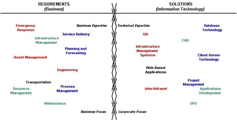
On the flip side, business units have a mandated responsibility to run their own individual businesses efficiently. In general, a business unit's corporate focus is secondary to the primary business directive, be it service provision, resource management, engineering, utilities, mapping, etc. IT is the best situated to provide a corporate focus to information and IT management. IT, with involvement from the business units, is in the best position to determine the corporate direction for IT development projects. Of course, single point solutions, although being generally cheaper in the short term, as well as quicker to implement, do not provide a vehicle for the remainder of the corporation to leverage against them. In the same token, corporate solutions generally cost more in the development process (typically at least an order of magnitude more, depending on the complexity of the project), but will start to see a higher return on investment in the longer term.
The key philosophy that serves as the foundation to successful information systems development projects, including GIS implementations and applications, is as follows: information is the asset, not the technology. This simple philosophy means that the technology is secondary to the information it manages. The foundation of IT over the past 30 years since Codd developed his relational model for information management [Codd, 1970] is solid, with little changes to the model. Recent developments have now been realized with the addition of object-oriented concepts; however, this object-relational approach is still founded on relational theory.
What does this mean for the corporate business unit needing to implement spatial information management? Simply, they must begin to understand the information they must manage and the inter-relationships between the data; and, this must be done in the context of relational theory. The most successful IT projects are those in which the business units have a solid understanding of not only their day-to-day business but also the underlying information technology used to support it; hence, in turn, becoming a key player in the information systems development process.
In this evolution of information management, business and IT must now function as real partners, both parties responsible for contributing to the costs and practices necessary to achieve enterprise objectives.
There are many factors that affect the successful implementation of enterprise data management and information technology solutions. These include the organizational structure in place, the willingness and ability of all levels within the enterprise to pursue and adopt new technologies and business practices, and the funding or budget mechanisms in place that are necessary to facilitate implementing those desired enterprise objectives.
The City of Calgary has recently undergone an organizational review resulting in the consolidation of over 20 departments into 5 portfolios coordinating the activities of 27 business units. This re-organization is intended to combine similar service providers and streamline processes required to provide the many services to the citizens of Calgary. Figure 2 illustrates the Corporate structure. Note the location of Information Technology Services in the structure, compared with the various other operational units, such as EMS and Fire, Assessment, Transportation Infrastructure and Engineering Services.
Figure 2: The Corporate Organizational Structure at the City of Calgary
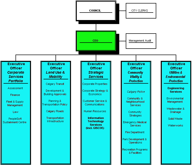
Although this structure maximizes effectiveness and efficiencies in public service delivery, this structure also provides a unique challenge to ensure corporate strategies are adopted across the portfolios.
Within the City of Calgary's organizational structure, there are a number of key business units who are primary stakeholders in the creation, maintenance and management of core spatial information. Engineering Services provides the corporation with approximately 80% of this core spatial information: legal base, ownership/parcel base, road network, aerial survey. Management of these data sets had their origins within the CAD environment. However, Engineering Services is currently migrating these data sets to database management systems. Another key business unit is Development and Building Approvals which is responsible for the administration of the use and development of land, specifically the subdivision process and addressing (a key component of the Road Network).
The GIS Centre of Excellence (GISCOE) is a corporate initiative to leverage Esri's GIS technology to the Corporation. To ensure success, a strategic alliance has been established between Engineering Services (the key corporate business unit relating to spatial information management) and GISCOE (the corporate initiative) to work towards better management of spatial and related information within an Enterprise GIS. This alliance, together with the political will to succeed, is working closely to ensure that spatial information management receives the highest priority, from spatial data collection (aerial survey, mobile mapping, GPS, etc.) through to dissemination, in a unified and corporate spatial information management process.
Information Technology Services (ITS) is the corporate IT service provider. Although GISCOE resides within the ITS family at the City of Calgary, it is closely associated with the various business units within the corporation requiring GIS application development and software solutions. Because GISCOE is strongly related to both the business units and ITS, it is situated in the perfect position to provide technical solutions to business problems as discussed above.
One of the core information management principles in place at the City of Calgary is that of sharing information. While information may be produced by one particular business unit, attempts are made to create and manage it in such a way that allows other business units to leverage against it downstream from the source. This ability to share the same information among many business units across an organization makes good common sense, but this goal is often difficult to obtain in reality.
Another general IT principle being implemented is a "buy versus build" approach to acquiring and implementing application solutions. Packaged enterprise technology solutions often come with slightly-less-than-fully "open" systems, and managing the access to, replication from, and integration with other enterprise applications becomes more important. Buying enterprise IT solutions rather than building them in-house may be cheaper up front, but this approach requires more development be placed on information integration functionality and tools to manage sharing information between these systems.
Given the emerging data integration complexities described above, another principle being pursued is to minimize the number of platforms, applications, and operating systems that are being used. As with spatial data collection and management tools, it becomes critical that the most cost effective enterprise solution be implemented, not a solution that just fits one business area.
The City of Calgary has world-class base and other spatial data sets. The Digital Aerial Survey, an initiative that was implemented as a result of an earlier corporate GIS initiative (the CALSIM Project), is kept up to date on a yearly basis. This key data set has a spatial accuracy of better than 15 cm absolute. As a result of this accuracy and the high feature capture ratio, its corporate utility is widespread. However, there are inherent challenges that need to be met to make more efficient use of this information. As an example, DAS can capture approximately 50-60% of fire hydrants with a high spatial accuracy within the city. Waterworks currently maintains a complete database of fire hydrants but uses coordinate information obtained from design drawings. Waterworks Drafting reconciles the Waterworks fire hydrants with the accurate coordinates obtained for the DAS fire hydrant. The concept of DAS fire hydrant versus Waterworks fire hydrant creates redundancies and inefficiencies. Add one more dimension to the mix with the Fire Department, who currently maintain a separate database of fire hydrants that function in case of emergencies. The benefits of adopting the concept of a corporate feature become very clear.
The Legal Survey Fabric, and Ownership Parcel Fabric that is built upon it, utilizes digital submission of subdivision plans throughout the three phases of the subdivision process (Tentative, Approved Tentative or Preliminary, and Registered Phases). Management of the LSF resides in an Oracle application that was developed in-house.A key development to meet this challenge is the base mapping management application within the Geomatics Division of Engineering Services. The Geomatics Spatial Database Application (GSDA) addresses the current lack of production-ready high-end base mapping management utilities in GIS technology today. It is a production application that integrates digital subdivision plans into the LSF. GSDA manages all history of survey points and is an efficient production system for base mapping management through a CAD environment.
The Single Line Road Network is also an Oracle application that is utilized throughout the Corporation. A corporate initiative is currently underway (July 2001 - December 2002) to look at redesigning the product and creating a tighter integration with the addressing component (see later section in this paper on a discussion of this corporate initiative).
All the above data products are currently leveraged to the Enterprise GIS environment (currently Esri's SDE 3.0.2.2, but migrating to ArcGIS 8.1). The current challenge is to manage these and other spatial data sets seamlessly within the ArcGIS environment.
A new technology complimentary to aerial surveying is mobile mapping technologies. In 1998, the City of Calgary embarked on a pilot project to assess the applicability of mobile mapping technologies as a means of mass data collection [Szarmes and Fediow, 1999]. A main finding of this study was its capacity to compliment the current DAS initiative. Interest in this technology has recently been achieved as a means to capture traffic signs throughout Calgary for an infrastructure maintenance and work order system in use by Traffic Field Operations. Of course, applicability of this type of technology reaches far beyond those of just managing signs, so the challenge is to introduce a strategy for capturing corporate spatial features and disseminating this information to the respective stewards and maintainers.
Given the above core data sets and data collection techniques, GIS can be leveraged to integrate spatial and other tabular data, hence allowing combinations and new aggregations to occur that weren't possible before. For example, census data, parks open spaces, (graphic for census aggregation?), dynamic census driven block faces for solid waste. These are all examples of how core base data can be used as the foundation to build additional valuable data sets.
Data structures and modeling can be extremely complex, even more so when one considers object modeling. However, this paper will focus on a higher level analysis of data structures in the context of information sharing. As discussed in the previous section, a number of business units can have a vested interest in the management of a spatial feature. Considering the fire hydrant example, three main business units maintain three separate instance of the same feature and use the feature in distinctly different ways. This duplication creates a severe disconnect and potential problems. The philosophy behind corporate feature management can be discussed on five levels: feature, attribute, relationships, states and stewardship.
A corporate feature resides in one location to be viewed by many users as required. Ownership of this feature resides with the corporation (i.e. a governance body). Stewardship of the corporate feature rests with the business unit who has the power to create and remove the physical feature. The requirements of the corporate feature are determined through a facilitated or moderated session of the governance body. At this session, the key attributes, data (feature and attribute) sources, stewards and relationships with other corporate features are determined.
The corporate feature has a number of user-defined attributes, as determined from the facilitated session. Features and attributes may have relationships with other features. Data sources and their inherent accuracy are also determined on a per-attribute basis. The concept is simple. Take for example the fire hydrant. When the hydrant is planned for a new subdivision, its feature is established and the coordinates assigned are sourced by the feature steward. The accuracy of the coordinates will be a function of the base map and design drawings. The source of the attribute data will list the level of accuracy as part of its metadata. A data source does not necessarily imply stewardship. However, a data source is documented as to the roles and responsibilities for which the data source is accountable.
A corporate feature can go through a set of states. In general, there are five major states as follows: planned, designed, implemented/established/existing, planned for removal, removal (or any similar terminology). The steward of the feature has ultimate control of the life cycle of the feature and must ensure all users of the feature and associates attribute(s) are notified of pending changes through a well-established change-management process.
Spatial information management, including spatial analysis, is the underlying power of GIS. However, many users of spatial information have more advanced technical requirements for the designs they produce and use; hence, CAD has emerged as a well-established utility in industry. At the City of Calgary, CAD is used extensively throughout the organization. Over the last decade, users have dramatically extended the capabilities of CAD by developing underlying database management systems linked to the designs. This is a simple spatial management approach for single point solutions but has generated a number of independent and segregated databases.
The above has left an interesting challenge: how to change the philosophy of the CAD user community within the corporation to adopt a more corporate focus in spatial information management and spatial data sharing. The authors believe that both CAD and GIS are merely tools. If one takes a step back, again it becomes clear that it is the information that is the asset, and that information is best managed in a well-defined and accessible database environment (now evolving rapidly into an object-relational management approach). This simple philosophy transcends the traditional barriers that exist in the GIS and CAD user communities because it takes the focus off of the tool and places it solidly on the assets themselves. It also means that the two traditionally dipolar communities have much more in common than originally thought.
Spatial information is now being provided and required in ways not previously available. To a much larger degree, spatial and attribute information that are sourced in separate environments are being joined and analyzed in the GIS environment. We want to get away from the overhead associated with CAD data conversion and replication and source the data in a well-integrated information system. We are looking to the power of Esri's ArcGIS object environment to set us on the right course.
The GIS Centre of Excellence at the City of Calgary was established not only to help business areas understand and develop GIS functionality to provide service to its clients (citizens), but more importantly, to help determine what the enterprise spatial data requirements actually are, and to then help ensure these requirements are achieved.
Ultimately, it is the individual business units that will continue to create and maintain spatial information, and the process infrastructure being developed must account for the resource requirements for providing enterprise information from separate business areas. The process infrastructure must also account for the various funding mechanisms required.
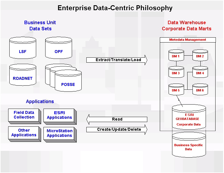
Currently, the Corporation is implementing a data warehouse initiative surrounding a corporate approach to information management. From a spatial information perspective, the corporate GIS tool, ERSI's ArcGIS environment, fulfills the requirements of a spatial warehouse, as illustrated in Figure 3. This data-centric philosophy - a philosophy that includes Esri's Geodatabase - also accounts for inter-application integration outside of the warehouse where it is deemed necessary.
Figure 3: An Enterprise Data-Centric Philosophy
The traditional ideas around data stewardship, as well as the responsibility of the business unit in practicing due diligence and standard data management practices, are still valid. However, the integration of spatial and non-spatial data into new data formats will require further definition of what stewardship will mean in the near future. Stewardship also implies the establishment of a governance body that is mandated to regulate standards, similar to those typically applied in IT departments in other corporations.
Business units that create and supply data to the Corporation are ultimately responsible for the quality, accuracy, and other use constraints relative to the data. The federated information management environment at the City of Calgary makes managing stewardship and accountability issues more important than in a centrally controlled environment.
In order both to be successful at corporate spatial information management and also to facilitate spatial data sharing, there are four key components that need to be involved and/or addressed: business units, ITS, governance and a funding mechanism. The role of the business unit in this regard is primarily to provide the detailed list of requirements and a business case for information management. The business case requires supporting understanding of the current costs of doing business and the benefits of systems development and/or redesign.
Within the context of the organizational framework described above, and general IT data management principles being followed, the City of Calgary is creating a Spatial Information Management Process Infrastructure to help facilitate efficient and effective enterprise spatial information management. While there are many ways this could be accomplished, the approach being implemented is much more a "bottom up", rather than a "top-down," approach through the organization.
An operational spatial data working committee has also been established with representatives from Engineering Services, GISCOE and other key business users and providers of information. This group is focusing on changes and processes that can be implemented cooperatively, at a day-to-day operational level. A GIS Steering Committee has also been established. This committee is composed of managers primarily from operational business units, with ITS representation as well. Executive decisions about managing key spatial information assets are being made by this group as required. The role of ITS is in the provision of a corporate focus to information management, to bring to the table other similar requirements from the remainder of the corporation, and technical options and solutions.
The main advantage in this bottom-up rather than top-down approach is that the actual business units that are most affected, in collaboration with ITS, are finding solutions to more efficiently collect, manage, maintain and share spatial information in a more corporate and collective manner.
The City of Calgary is currently embarking on a unique challenge that touches on all the aspects discussed in this paper: CAD versus GIS, data utility, funding, accountability, corporate spatial information management, data warehouse, attribute-level stewardship, multiple data sources and users, etc. The Corporate Addressing and Mapping (CAM) Project will challenge the way our corporation develops information systems and will go far in defining a true Spatial Information Management Process Infrastructure at the City of Calgary.
The CAM project is composed of two streams: a redesign of the Single Line Road Network and a design of a corporate addressing system that is tied to the road network (i.e. bringing together what was traditionally spatial and tabular data). The principle driver of the project is to improve emergency response (tri-services) and reduce liability for these emergency services. From a technical standpoint, the challenge is to deliver a corporate integrated road network and addressing system. Because it touches on all critical aspects of corporate spatial information management, this project will be instrumental in defining a template Spatial Information Management Process Infrastructure that can be leveraged in future similar corporate initiatives involving spatial and spatially-related information.
This paper has endeavoured to cover a broad scope in approaching a viable solution to spatial data sharing at the City of Calgary. The development of a methodology for facilitating this data sharing is key in ensuring successful enterprise information management. Alliances between business units and ITS is critical whereby each brings to the table a solid understanding of the other's field. In this way, both can work together towards a defined goal. At the City of Calgary, Engineering Services (the business unit responsible for stewardship of about 80% of the corporate spatial information) is working closely with the GIS Centre of Excellence and other business units to ensure access to core spatial data is maintained efficiently in the corporate GIS environment.
The Spatial Information Management Process Infrastructure is evolving through the partnerships and alliances being developed rather than being imposed. The corporate CAM initiative, and the work of both the GIS Steering Committee and the GIS working group committee will create the necessary mechanisms and processes required to help facilitate Enterprise Spatial Data Management. Other key corporate projects, such as the enterprise data warehouse initiative, will go far in helping to establish a vehicle for spatial data sharing.
Codd, Edgar F., 1970. A Relational Model for Large Shared Data Banks. Communications of the ACM 13(6): 377-387.
Szarmes, Michael and S. Fediow, 1999. Assessing Mobile Mapping Technologies for Applications at The City of Calgary. The City of Calgary.