Figure 1. 100K aggregation example.

Wendy L. Berelson
Paul A. Caffrey
Jeffrey D. Hamerlinck
The Spatial Data and Visualization Center at the University of Wyoming
is using a customized ArcView approach to define hydrologic unit boundaries
in a statewide coordinated effort to develop the national Watershed Boundary
Dataset (WBD) for Wyoming. The first phase of the process is semi-automated
using National Elevation Dataset (NED) derived watersheds created by USGS
EROS Data Center. These watersheds are used to create draft boundaries
at a 1:100,000-scale. The second phase of the process uses the DRG-Es (Digital
Raster Graphic – Enhanced) as a backdrop for digitizing at 1:24,000-scale
and the National Hydrography Dataset (NHD) as a reference for watershed
naming.
Background
Beginning in the early 1970’s the USGS delineated four levels of nested watersheds across the United States (Seaber, P.R., Kapinos, F.P., and Knapp, G.L., 1987). The four levels are regions, sub-regions, basins and sub-basins (basins and sub-basins were formerly referred to as accounting units and cataloging units). Hydrologic units are nested within each other from the smallest (sub-basin) to the largest (basin). Each level has a two digit hydrologic unit code (HUC). These delineations are often referred to as 8-digit or 4th-level HUCs.
More recently, Federal Agencies have been coordinating development of digital spatial water data under the charter of the Federal Interagency Subcommittee on Spatial Waters Data (SSWD). The SWDD has identified the National Watershed Boundaries Dataset (WBD) as an important dataset to include in the National Spatial Data Infrastructure (Rea, 2000).
When completed, the WBD will provide a high resolution, nationally consistent, seamless base layer for watersheds within the United States. The WBD will further divide sub-basins into watersheds and sub-watersheds also known as 5th and 6th level hydrologic units. The watersheds and sub-watersheds will consist of 10 and 12 digit HUCs, respectively. Mapping of larger-scale watersheds will provide accurate watershed boundaries for use by federal and state agencies in local resources planning and management.
To facilitate the creation of this data layer, SDVC has developed several tools in ArcView to use during the two phases of the project. Phase I involves delineating watersheds at 1:100,000-scale using watersheds derived from the National Elevation Dataset (NED). Phase II involves digitizing the watersheds at 1:24,000-scale using the aggregated NED derived draft 100,000-scale watersheds and the Digital Raster Graphics Enhanced (DRG-E) as background data layers. The majority of process steps use ArcView 3.2 however, ArcInfo 8.0 is used for creating topology and conflating data.
Protocol for the delineation follows the Federal Standards for Delineation
of Hydrologic Unit Boundaries (Natural Resources Conservation Service,
2001). Sizing standards call for the creation of 1:24,000-scale 5th level
(40,000-250,000 acres) and 6th level (10,000-40,000 acres) level hydrologic
unit boundaries. Boundaries are being delineated on a basin-by-basin priority
scheme developed by the IHUG, and dictated in part by available funding
and management needs.
The first set of tools allow an individual to select the desired derived
watersheds and aggregate them to the appropriate acreage for 5th level
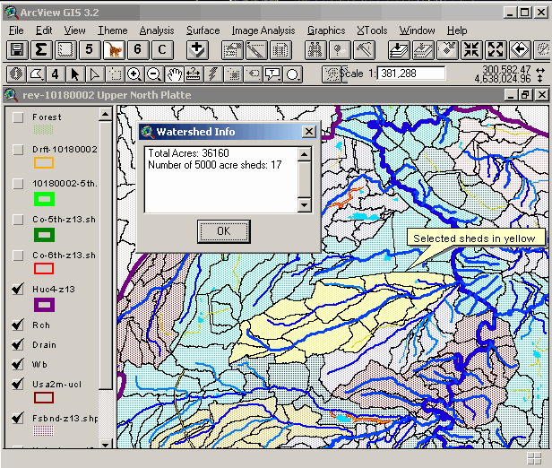
or 6th level watersheds (Figure 1). After selecting the watersheds to aggregate,
the sum tool is used to calculate the total acreage (Figure 2).
The user can repeat the selection process until the acreage and watershed
outlet are acceptable. Once the user is satisfied with the selection, the
polygon is attributed with the last two digits of the hydrologic unit code
(HUC) number at the appropriate level. This is done by using the 5th
or 6th level tools, which assign the 10 and 12 digit codes, respectively
(Figure 2). The attributes are later used to dissolve the smaller NED-derived
watersheds into the larger 5th and 6th level watershed polygons that make
up the draft 100K boundaries. The 4th level tool is used to assign
the 4th level HUC by querying the 250k hydrologic unit boundary coverage
(Figure 2). The final process steps for Phase I involve running several
scripts that manipulate the attribute table to append the 4th level HUC
number to the two digits of the 5th and 6th level HUC to get the final
10-digit and 12-digit draft HUC.

Figure 1. 100K aggregation example.

Figure 2. 24k attribution tools.
A comments tool was created to allow the user to describe artifacts in the watershed primarily resulting from areas of low relief (e.g. edit outlet, non-contributing area). In areas where there are errors in the NED and therefore in the watershed boundaries, the aggregated polygons are edited so that the boundary is more clearly defined (U.S. Geological Survey, 2000). Areas where editing is needed may be identified by querying the comment field.
To aid in determining the appropriate locations for watershed boundaries and outlets the 100K NHD is used as a backdrop and where necessary the 24K DRG-E’s are reviewed. For determination of some outlet locations a screen capture of the area in question is sent to the IHUG and other regional agency representatives with local knowledge for consultation.
Phase II Methods– 1:24,000-scale Delineations

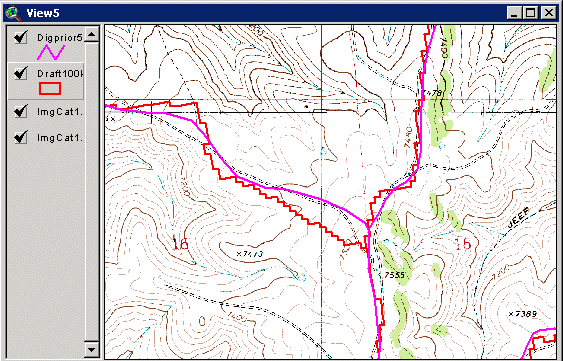
Figure 3. Example of 24K digitized line with 100K draft line and DRG-E backdrop.
After review, the 24K linework and the 100K draft boundaries are converted to coverages in Arc/Info. The 100K HUC number attribute is then conflated to the 24K linework using the PUT command in ArcEdit. As required by the federal guidelines, double precision is used for all processes.

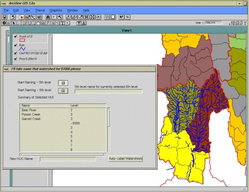
Figure 4. Naming tool interface.

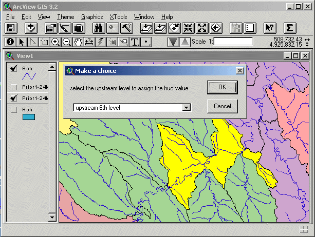
Figure 5. Downstream hydrologic unit interface.
Rae, Alan. 2000. Development of a National Watershed Boundary Dataset. In Proceeding of the Twentieth Annual Esri International Users Conference.
Saber, P.R, Kapino, F.P, and Knapp, G.L. 1987. Hydrologic Unit Maps: U.S. Geological Survey Water-Supply Paper 2294, 62p.
U.S. Geological Survey. 1999. National Mapping Accuracy Standards. U.S. Geological Survey Fact Sheet FS-171-99.
U.S. Geological Survey. 2000. Creating a Standardized Watersheds Database for the Lower Rio Grande/Rio Bravo, Texas. U.S. Geological Survey Open-File Report 00-065, p.10.
Verdin, Kristine. 2000. Development of the National Elevation Dataset - Hydrologic Derivatives (NED-H). In Proceeding of Twentieth Annual Esri International Users Conference.
Author Information
Wendy L. Berelson
Assistant Research Scientist
University of Wyoming
Spatial Data and Visualization Center
P.O. Box 4008, University of Wyoming
Laramie, WY 82071-4008
Phone: 307-766-2735 Fax: 307-766-2744
e-mail: berelson@uwyo.edu WWW: www.sdvc.uwyo.edu
Paul A. Caffrey
Assistant Research Scientist
Spatial Data and Visualization Center
P.O. Box 4008, University of Wyoming
Laramie, WY 82071-4008
Phone: 307-766-2735 Fax: 307-766-2744
e-mail: caffrey@uwyo.edu
Jeffrey D. Hamerlinck
Associate Director
Spatial Data and Visualization Center
PO Box 4008, University of Wyoming
Laramie, WY 82071-4008
Ph: 307.766.2532 FAX: 307.766.2744
Email: itasca@uwyo.edu