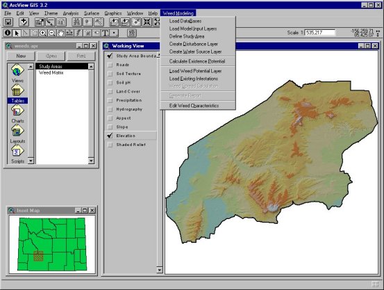
Figure 1 -- WISP Modeler GUI
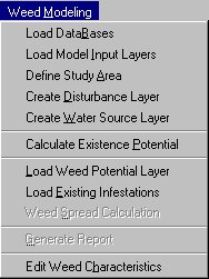
Figure 2 -- Weed Modeling Menu
In order to attempt management of weeds, field technicians conduct weed
surveys. The purpose of these surveys is to help managers:
This information is often displayed on maps showing weed distribution and the relative severity of the infestation. Mapping simplifies communication among people working with weeds, especially those implementing control measures. Survey data can be combined with other data, within a GIS, to increase their utility (Johnson, 1999). It may even be possible to combine GIS and remote sensing technology and forego much of the field survey practice.
One of the biggest problems facing resource managers has been tracking locations where severe weed problems exist. That is mostly due to the need to stretch limited funding to assess these sometimes swift and widespread weed invasions. Effectively determining and focusing on the weed "hotspots" will allow managers to better control weed infestations at a lower cost. A Geographic Information System (GIS) offers a solution to this problem by helping land managers pinpoint problem areas using available spatial digital data while minimizing the need for and the expense of field-based weed assessments.
This paper outlines the development of the Weed Invasion Susceptibility Prediction (WISP) Modeler, an ArcView 3.2 extension developed to assist environmental managers in determining the potential for selected noxious weed infestation and dispersion in Wyoming. WISP Modeler is currently in alpha version and is anticipated to be released for general use in 2002.
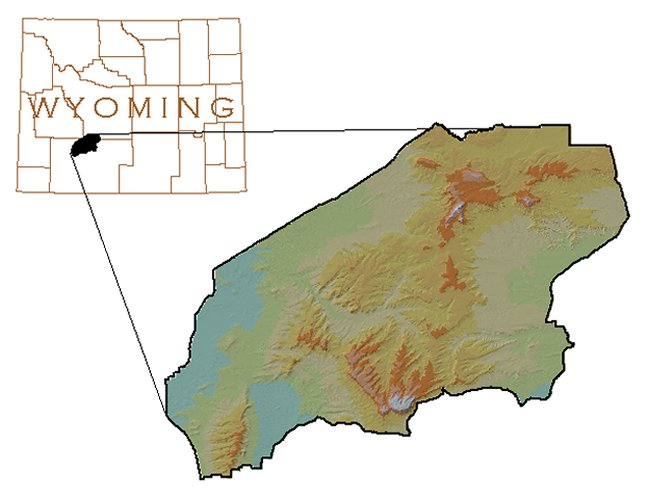
The WISP Modeler was initially developed to assist the USDI Bureau of Land Management (BLM) in managing weed infestations in the Jack Morrow Hills Wilderness study area near Rock Springs, Wyoming. The primary result was an ArcView application that will help predict the occurrence and spread of five weed species within semiarid rangelands: black henbane (Hyoscyamus niger), hoary cress (Cardaria draba), leafy spurge (Euphorbia esula), perennial pepperweed (Lepidium latifolium), and spotted knapweed (Centaurea maculosa).
The Susceptibility Prediction Model
This part of WISP Modeler uses nine environmental and land use characteristics to determine the potential for a weed to establish and survive in a particular setting. Factors were determined to be the most important to the suitability of land to support a weed are:
The predictive model goes through the following process to derive a final grid that depicts the potential for a weed to exist in certain areas.
The Weed Spread Model
After the susceptibility has been determined for an area, the spread model uses the spread factor in the weed database, in conjunction with the susceptibility, to determine the annual spread of that species. The process is outlined below:
Spotted knapweed (Centaurea maculosa) was introduced from Eurasia as a contaminant of alfalfa and clover seed. It is ranked as the number one weed problem on rangeland in western Montana (Whitson, 1996). Other western states, including Wyoming (USDA 2000), are experiencing a reduction in desirable plant communities as this species is allowed to spread. Knapweeds are considered a disturbance plant, which means that they readily establish themeselves on any disturbed soil. Additionally, their early spring growth makes them competitive for soil moisture and nutrients. There is some evidence that knapweeds release chemical substances which inhibit surrounding vegetation. This species is best controlled when herbicides are applied during early growth stages (Whitson, 1996).
Hoary cress (Cardaria draba), also known as whitetop, is a perennial that is common on alkaline, disturbed soils and is highly competitive with other species once it becomes established. Just like knapweeds, hoary cress starts growth very early in the spring. Hoary cress can be effectively controlled with herbicides (Whitson, 1996).
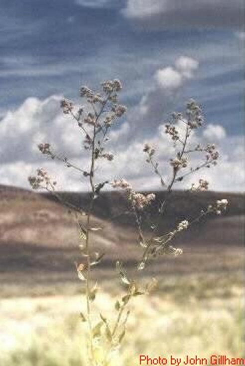
Perennial pepperweed (Lepidium latifolium) is a native of southern Europe and western Asia but is now found in many parts of the United States. It has been declared noxious in a number of western states. Deep-seated rootstocks and a waxy coating on the leaves and stem make this weed difficult to control. Perennial pepperweed grows in waste places, wet areas, ditches, roadsides, and cropland (Whitson, 1996).
Leafy spurge (Euphorbia esula) is native to Eurasia and was brought into the United States as a seed impurity about 1827. However, it seems to be a serious problem only in North America where it infests almost 2.5 million acres, mostly in southern Canada and the northcentral United States. It has been reported to cause severe irritation of the mouth and digestive tract in cattle which may result in death. Capsules explode when dry, often projecting seeds as far as 15 feet. Seeds may be viable in the soil for at least 8 years. This, and an extensive root system containing large nutrient reserves, make this weed extremely difficult to control (Whitson, 1996).
Black henbane (Hyoscyamus niger) is a native of Europe and has been cultivated as an ornamental plant. It has spread throughout the United States and is a common weed of pastures, fencerows, roadsides, and waste areas. Black henbane contains hyoscyamine and other alkaloids which have caused occasional livestock poisoning. However, the plant is usually not grazed by animals and is consumed only when more palatable forage is not available. Henbane alkaloids have been used in the past, and are currently used, as medicines at controlled dosages. It is considered a poisonous plant to humans (Whitson, 1996).
|
SPP_CODE |
COM_NAME |
SCI_NAME |
WTR_SRC |
LOW_EL |
HIGH_EL |
LANDCOV1 |
LOW_PH |
HIGH_PH |
SOILTEX1 |
SLOPE |
DISTURB |
ASPECT1 |
PRECIP |
LIF_CYCL |
RATE_SPD |
SEED_LIF |
|
HYSNI |
Black henbane |
Hyoscyamus niger |
3333 |
1524 |
2743 |
SG |
7.7 |
8.2 |
SL |
36 |
16 |
S |
4 |
B |
27 |
4 |
|
EPHES |
Leafy spurge |
Euphorbia esula |
500 |
1156 |
2343 |
RP |
6.8 |
8.4 |
SL |
36 |
400 |
S |
8 |
P |
7 |
8 |
|
LEPLA |
Perennial pepperwe |
Lepidium latifloiu |
33 |
305 |
2591 |
SG |
7.6 |
8.7 |
CL |
36 |
3333 |
S |
3 |
P |
27 |
|
|
CENMA |
Spotted knapweed |
Centaurea maculosa |
1200 |
578 |
3040 |
SG |
6.5 |
8.4 |
S |
36 |
300 |
S |
8 |
P |
14 |
15 |
|
CADDR |
Hoary cress |
Cardaria draba |
3333 |
1219 |
2896 |
SG |
7.5 |
8.7 |
SL |
36 |
16 |
S |
3 |
P |
27 |
3 |
ArcView 3.2, Spatial Analyst and Avenue were used to develop this application. It was determined that ArcView 3.2 and Spatial Analyst would be available to most users of WISP Modeler, particularly those in the BLM field offices. ArcView would also provide an easy-to-use desktop environment for land managers that are not proficient in GIS.
We took a semi-modular approach to building this extension. The database stands alone and can be modified to increase of the number of weed species WISP Modeler can model. This allows weed managers to expand the scope of WISP Modeler without needing to do additional computer programming. In addition, the user can develop any model input layers that they wish to use in their project -- as better data become available, they can be used to model weed existence and spread with greater accuracy. Because of this design, WISP Modeler will not become quickly obsolete, as happens to many applications.
WISP Modeler has a slightly customized Graphical User Interface (GUI). This simply adds one dropdown menu to the View, with several new menu items. This extension also relies on Spatial Analyst because of its use of grids to perform most of the modeling.
Figure 1 shows the GUI for WISP Modeler. In addition to the standard ArcView and Spatial Analyst tools and menus, the display consists of a dropdown menu entitled Weed Modeling. Figure 2 shows this menu in more detail.
Figure 2 -- Weed Modeling Menu
The options under the Weed Modeling menu include the following:
Load Databases
The weed matrix is the information base for WISP Modeler and is where all
the information about each weed species is stored. The study area database
has pre-defined study areas and a file name for each study area boundary theme.
These databases are loaded as Table documents and used for many of WISP
Modeler�s primary functions.
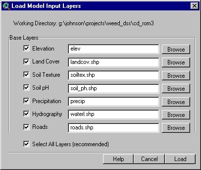
Load Model Input Layers
Before calculating a weed existence potential model or a weed spread model,
data needs to be added to the View. Loading these model input
layers will give the model the parameters it needs to perform all of its
calculations. Pre-existing default layers or other tailored data can be
loaded here. There is also the option of adding themes manually.
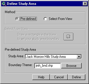
Define Study Area
After loading model input data, a study area must be defined in order for the
model to work correctly. This often reduces processing time by defining a
more manageable analysis focus. The definition of the study area can be done
one of two ways; by selecting a study area from the database, or by
defining a rectangle in the View. If a rectangle is defined in the View, a
new shapefile will be created and the file name will be added to the study
area database.
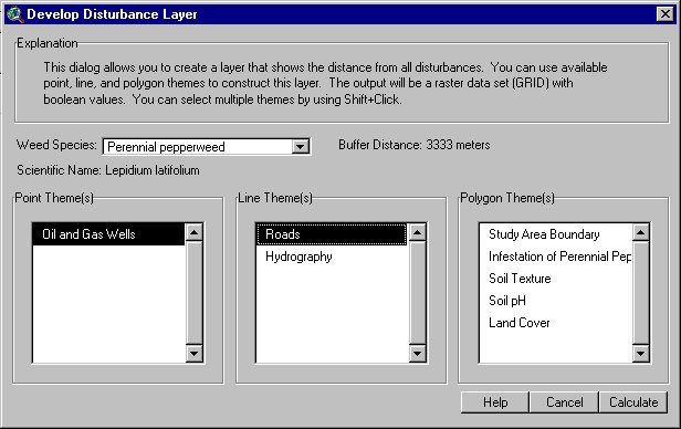
Create Disturbance Layer
Because there are a variety of sources for disturbance, a composite
disturbance layer needs to be developed separately. This tool will
allow the user to develop such a layer from a variety of data sources --
point, line or polygon. Examples of disturbances are oil and gas well
pads, roads, and livestock trails. This function takes each of the
selected input themes and buffers them with the appropriate distance
from the weed database. The output is a Boolean grid that represents
that buffer distance.
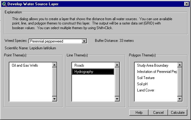
Create Water Source Layer
Creating a water source layer works the same way as creating a disturbance
theme. This creates a Boolean grid that shows where weeds are likely to thrive
in reference to water sources.
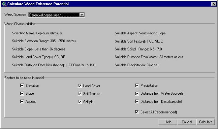
Calculate Existence Potential
The existence potential is the likelihood that a weed species will be found
in a particular area. This is rated from 0 - 9, with 0 being the least
likely to sustain that specific weed and 9 being the most likely. This model
adds nine factors -- elevation, slope, aspect, soil pH, soil texture, distance
from water sources, distance from disturbances, annual precipitation, and
land cover -- to compute the final potential.
Load Weed Potential Layer
If a weed existence potential model has already been run, this option can
be used to load that theme. The theme is named Potential for <species>,
where <species> is the name of the species in question. This theme can
then be used in the spread calculation.
Load Existing Infestations
This option loads a theme with existing infestations. This can be
from a mapped invasion area or GPS data. Any type of feature
theme - point, line, or polygon - can be loaded, but the spread model
will only work with polygon themes. Thus, the user would need to buffer
points or lines.
Weed Spread Calculation
This predicts the spread of noxious weeds in one-year
intervals up to 25 years. The years displayed in the View are 1-5,
10, 15, 20, and 25. This model uses the weed existence potential and
the current infestations to develop a grid that shows the spread of a
weed for each year.
Generate Report
Once the weed existence potential and current infestations are loaded, a report
can be generated for that species, either in MS Word or Crystal Reports. The
report will have some basic statistics - for example, the
percentage of the study area infested by that species. The report will also
have information on the ecology, spread, and control of that species, if it
is available.
Edit Weed Characteristics
Use this function if a new species needs to be added to the database or the
characteristics of a species already in the table need to be changed. This
is also useful for calibrating the environmental characteristics of different
weed species.
Perennial pepperweed was recently mapped in the JMH wilderness area using GPS. Thus, it was used for the development and testing of WISP Modeler. The entire modeling process is described in detail below.
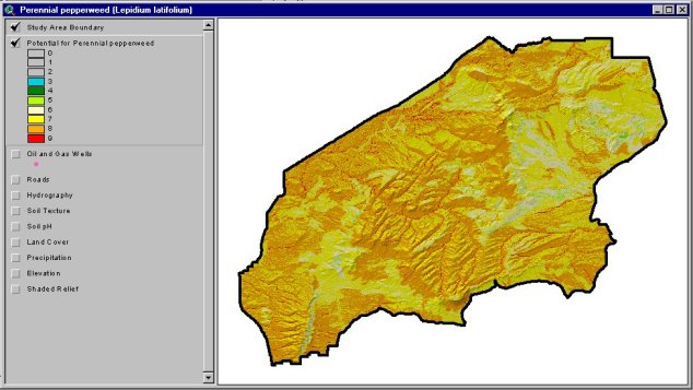
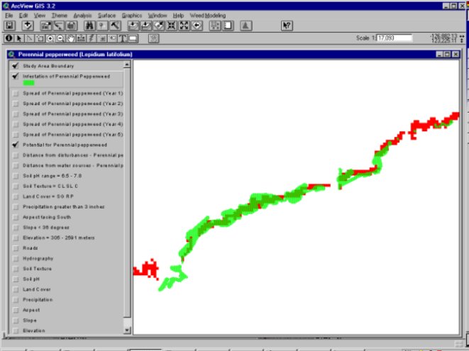
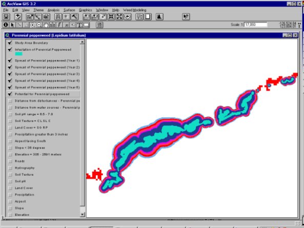
WISP Modeler shows that there are 115.64 acres in the JMH study area that show the highest potential for perennial pepperweed infestation. This means that there were 115.64 acres in which all 9 input factors were present. From the GPS mapping effort, there were an estimated 33 acres of land infested with perennial pepperweed in 2000. The spread model more than doubles this to predict over 68 acres infested after one year. Until more data on perennial pepperweed are collected this summer, it will be unknown whether or not this number is accurate. The Department of Renewable Resources, however, conducted some accuracy testing in other areas of the state and determined that WISP Modeler predicted the spread of leafy spurge with 89% accuracy.
In its current stage of development, WISP Modeler is not yet a true expert system tool. It would be beneficial to land managers to move this application into that realm because it would provide more assistance in the decision-making process. Second, some utilities can be modified so they follow more intuitive spatial analysis methods. Alternatively, a similar application can be developed to utilize the more flexible programming capabilities of the ArcGIS platform. As GIS improves its capability to use remote sensing data, this can also be incorporated into WISP Modeler.
The predictive model could be improved by conducting additional research on placing weight on different environmental factors. The current version of WISP Modeler places the same emphasis on all input data, which may or may not be accurate. The spread model could be enhanced by developing a method to model weed transportation vectors (wind, water, wildlife), as well as incorporating the weed life cycle and seed life. Additionally, the spread model simply estimates the average expansion of an infestation and does not account for more growth in one direction than another.
Lastly, model accuracy can be tested as more digital spatial data become available for existing weed infestations in Wyoming. With several years of data available, the model can be calibrated to give the best results possible.
Each user of the application can maintain the weed database. Furthermore, there is potential to develop a web forum for the exchange of new weed species information. This would be available at either http://www.sdvc.uwyo.edu/WISP or http://w3.uwyo.edu/~annhild/WISP.html. You can visit either of these web pages for updates.
As WISP Modeler is still a prototype, the BLM is currently evaluating its utility and accuracy. An alpha version is available to anyone who wishes to test it. Enhancements to this extension will occur as funding allows. Meanwhile, it will only be available upon request, on CD-ROM, from the College of Agriculture Cooperative Extension Service on the University of Wyoming Campus. The final version of the WISP Modeler extension will also be available on the SDVC web pages at http://www.sdvc.uwyo.edu/WISP.
|
|
Perennial pepperweed Lepidium latifolium Analysis Date: March 2, 2001 StatisticsTotal study area: 617455.42 acres Area of highest potential: 115.64 acres Percentage of area w/ high potential: 0.00019% Area of infestation: 33.01 acres Percentage of area w/ infestation: 0.00005% |
Species Description
Perennial pepperweed (Lepidium latifolium L.), a plant often used by florists for both fresh and dried flower arrangements, is a serious invader that is quickly taking over the West. Spreading into marshes, pastures, and riparian areas, it creates monocultures and degrades the value and utilization of the land. There are about 175 species of Lepidium, but none of the native or introduced species found in western North America are very similar to perennial pepperweed (Young et al. 1995). Relatively little is known about L. latifolium other than its devastating effects on the areas it invades. A very competitive species, it typically creates thick monocultures that are too dense for other plants to survive and thus dominates the sites. In riparian zones, it interferes with the regeneration of many species such as willows and cottonwoods. It drastically alters the species composition and productivity of important herbaceous species in wetland areas (Young et al. 1995). The accumulation of thick, woody stems hinders nesting habitats for wildlife (Young et al. 1995). Perennial pepperweed also poses a tremendous risk to hay producers and ranchers. In areas such as the Humbolt River Valley in Nevada, hay meadows are being dominated by perennial pepperweed. It lowers the protein content and digestibility of hay (Young et al. 1995). Although little research has examined the species for toxins, it is a persistent rumor among livestock producers that L. latifolium may have poisonous qualities (Young et al. 1995; MSU 1999). Young et al. (1995) suggests that most cases of suspected poisoning occurred when horses were feed infested hay under confined conditions. Regardless, perennial pepperweed is a noxious species that poses a considerable threat to land managers.
Ecology and Spread
Lepidium latifolium is thought to have been introduced into the United States from either southern Europe or western Asia around 1900 as a contaminant of sugar beet seeds (Krueger and Sheley 1999; Miller et al. 1986). This Wyoming-listed noxious species (USDA 2000) is well established in New England, the West, and in Mexico (Young et al. 1995). In the past two decades, this weed has greatly increased its distribution throughout the western U.S., and is present in all western states except Arizona. It is particularly prevalent in Nevada, Oregon, Utah, and California. Sixteen counties in Wyoming and sixteen counties in Utah report perennial pepperweed invasions (Krueger and Sheley 1999). Within the Intermountain West, the species distribution is associated primarily with stream systems and riparian zones. However, perennial pepperweed is not limited to these sites and is known to be found in ditches, roadsides, waste areas, and pastures as well (Krueger and Sheley 1999). L. latifolium is a member of the mustard family (Brassicaceae). It is a vigorously spreading, root-creeping species that initially establishes from seeds or root fragments (Young et al. 1998). The plants are stiffly erect masses of stems generally from 1 to 3 feet (0.3 to 0.9m) tall, although they can reach heights up to 8 feet (2.4m) under wet conditions. It has a thin woody basal stem with a tuft of leaves and flowers spreading out at the top. The leaves are toothed, tapered, and 0.5 to 1 inch (1.3 to 2.54cm) wide. Flowers are quite abundant on this plant and are arranged in dense panicles of 6 to 8 flowers per cluster. Mid-summer blooms are a brilliant white, causing the species to be given a frequently used name of 'Tall whitetop' (Young et al. 1995). Seeds are produced in small, flattened pods about one eighth inch (3mm) in diameter and are normally a reddish brown color with an oval outline. Seeds do not dehisce from their pods at maturity, but rather fall at irregular intervals throughout the winter. There is no inherent dormancy system within the pepperweed seeds and buried seeds of perennial pepperweed may not be a prolonged source of reinfestation once a population is controlled (Miller et al. 1986). The species is very tolerant to saline soils, but is not limited to them (Young et al. 1995).The abiotic requirements for perennial pepperweed are a mystery because very little research documents environmental conditions required for this weed to establish. The Colorado Weed Management Association (CWMA 1999) lists pepperweed as having an elevation range from 5,500 to 8,000 feet (1,676 to 2,438 m) in central Colorado. This weed obviously has lower elevation ranges than 5,500 feet on coastal marsh invasions, so theoretically it could establish lower even in Wyoming. L. latifolium does not seem to require disturbance for establishment. While there is some evidence that poor condition riparian areas or pastures could be more susceptible to perennial pepperweed invasion (MSU 1999), it does not seem to be a prerequisite for this species.
Options for Control
Controlling this species is a difficult task because of its deep rootstocks and capacity for vegetative propagation. Because it generally establishes very close to surface water, control options are severely limited. Mechanical control methods are not recommended. Digging, mowing, or tilling encourages new root sprouts (Young et al. 1995). Varieties of herbicide treatments have been established to help control this weed. However, labels should be checked and strictly followed when dealing with any open water situations. For areas away from open water, control is much more feasible. Farmers have traditionally applied Glyphosate or 2,4-D (amine or low volatile ester formulations). These herbicides have profound effects on the aerial portions of perennial pepperweed plants, but do little to control the persistent underground portions, which often resprout again in the year following application (Young et al. 1998). Sulfonylurea compounds such as cholorosulfuron (Telar®) or metsulfuron (Escort®) have both proven to be more effective on perennial pepperweed control by greatly reducing sprouting from roots (MSU 1999; Young et al. 1995, 1998). Chlorosulfuron should be applied at one ounce per acre during bud to early bloom stage on non-cropland sites. Metsulfuron has been sufficient at one ounce per acre as well and should be applied before bud and bloom stages (but while still actively growing) (MSU 1999). Both herbicides should be mixed with a nonionic surfactant and used within 24 hours after mixing (Whitson et al. 1999). Neither of these chemicals is registered for use in open-water areas, but could be used in suppressing populations in such areas as native hay meadows (Young et al. 1998). No biological control agents have been approved for pepperweed at this time, because several valuable crops such as canola and cabbage that belong to the Mustard family may be damaged by control agents. As with most control programs, revegetation is a vital part in order to keep perennial pepperweed from reestablishing or dominating.
References and Information
CWMA 1999. CWMA - Colorado Weed Management Association.
http://www.cwma.org Colorado Weed Management Association, Granby,
Colorado.
Krueger, Jane and R. Sheley. 1999. Perennial Pepperweed.
http://www.montana.edu/wwwpb/pubs/mt9906.html Montana State University Extension
Service, Bozeman, Montana.
Miller, Gerald K., J. Young, and R. Evans. 1986. Germination of seeds of perennial
pepperweed (Lepidium latifolium). Weed Science 34:252-255.
MSU 1999. Montana guide - perennial pepperweed.
http://www.montana.edu/wwwpb/pubs/mt9906.html. Montana State University
Extension Service, Bozeman, Montana.
USDA 2000. United states department of agriculture regulated noxious weeds state list.
http://www.aphis.usda.gov/npb/statenw.html USDA, Baltimore, MD.
Whitson, Tom D., R. Stougaard, and S. Dewey. 1999. Weed management handbook:
Montana, Utah, Wyoming. University of Wyoming Cooperative Extension
Service, Laramie, Wyoming.
Young, James A., C. Turner, E. Charles, and L. James. 1995. Perennial pepperweed.
Rangelands 17(4):121-123.
Young, James A., D. Palmquist, and R. Blank. 1998. The ecology and control of
perennial pepperweed (Lepidium latifolium L.). Weed Technology 12:402-405.