This paper will discuss the use of ArcView Spatial Analyst software's ModelBuilder in determining the potential habitat for seven endangered, threatened or candidate species in Albany County, Wyoming, USA. The analysis was completed in support of a countywide Habitat Conservation Plan (HCP) developed by the University of Wyoming for the Albany County Planning Office. Eight data layers were examined within a matrix of habitat parameters characterizing each of the seven species. Subsequent models were then developed in ArcView to predict each species' distribution and occurrence. ArcView Spatial Analyst software's ModelBuilder is showcased as a means to organize and replicate complex HCP models for characterizing species of concern.
The broad stated purpose of the Endangered Species Act (ESA) of 1973 is to "...provide a means whereby the ecosystems upon which endangered species and threatened species depend may be conserved, [and] to provide a program for the conservation of such endangered species..."[16 § U.S.C. 1531 (b)]. The Act's approach is limited by protecting only those specific species identified by the Unites States Fish and Wildlife Service (USFWS) as being in danger of extinction in the foreseeable future. The current Act outlines several legal mechanisms to be used to achieve the stated purpose.
The essential first mechanism in this process is the federal designation or "listing" of species needing protection under the ESA (Cheever, 1997). Section 4 of the Act defines an endangered species as any species "...in danger of extinction through all or a significant portion of its range". The Act also defines threatened species as any species "...which is likely to become an endangered species within the foreseeable future throughout all or a significant portion of its range"[16 § U.S.C. 1532(20)]. In addition to the threatened and endangered listing classifications, the USFWS also has provisions to allow the agency to list species as a candidate. This candidate classification indicates there is sufficient information to list the species as endangered/threatened, however priority to previously listed species precludes the development of a proposed listing of a candidate species by the agency ( Endangered and Candidate Species). By prioritizing species the USFWS can design and direct its efforts toward the plants and animals in greatest need of protection. This listing process must follow a strict legal process guided by the "rulemaking" procedure in the Federal Register, and involves the participation of all interested parties. This process may take up to a year or longer. Once a species is listed a second tier of mechanisms within the Endangered Species Act must be followed that include measures of protection. One such mechanism is the creation of a habitat conservation plan (HCP). The general purpose of Habitat Conservation Planning can be summarized as a means to significantly reduce the "...regulatory burden of the act [ESA] on private landowners while addressing the habitat needs of listed species" (Babbit, 1996). This process may distribute the economic and logistic impacts of endangered species conservation among the community by covering a broad range of landowner activities under the legal protection of a HCP. Federally listed species under the ESA are protected against actions that will result in a "taking". A taking results from actions defined as "...to harass, harm, pursue, hunt, shoot, wound, kill, trap, capture or collect" a listed species [16 § U.S.C. 1532(19)]. Many listed species may be subjected to intentional or unintentional takings. The HCP process is designed to mitigate conflicts between private landowners or public land use interests, and the ESA interests (protecting listed species) by providing guidelines for policies on permitted "incidental take" of the species as defined in Section 10(a) of the ESA [16 § U.S.C. 1539(a)(1)(b)]. Upon approval of an acceptable Habitat Conservation Plan, the issuance of incidental take permits provides the mechanism needed to allow flexibility in the Endangered Species Act (Beatley, 1994). Once approved, Habitat Conservation Plans conserve specific areas for listed species within larger areas of land use to ensure the survival and recovery of listed species. These plans may allow specific land uses/activities to occur on or near portions of conserved land. These approved land uses/activities will "protect" landowners/stewards from unexpected government interventions because of new species or habitat discoveries. In other words, a HCP is designed to offset any potential harmful effects a proposed activity might have on a species, as well as to create assurances to landowners by implementing a "no surprise" policy for the participating parties in the process (USFWS: No Surprise Rule). Federal wildlife laws are enforced by the United States Fish and Wildlife Service, which also administers the Endangered Species Act. The agency receives and approves HCP proposals throughout the United States. The San Bruno Mountain HCP near San Francisco California was the first HCP in the country approved in 1982 (Beatley, 1994). This plan allowed developers to build on a portion of an endangered butterfly's habitat in exchange for restoring a significant area of the butterfly natural habitat. Since then, the USFWS has approved 341 Habitat Conservation Plans, covering approximately 30 million acres and protecting 200 endangered or threatened species (USFWS: HCP's). Aware of current trends in habitat conservation and the potential success a HCP can offer, the Albany County, Wyoming, Planning Department began considering the idea of creating a Habitat Conservation Plan in 1999. Since then, the County has commissioned the University of Wyoming's Planning Program to begin the preliminary research needed for creating a HCP for Albany County. Much of this work entails the identification of relevant species and their respective potential habitats located within the county. Albany County may contain potential habitat for seven endangered and threatened species, and the delineation of these habitats is necessary for identifying critical habitat areas needed for protection within a HCP. The USFWS is required to designate areas as "critical habitat" for all of the listed species. These critical habitats includes specific areas within and outside the geographic area occupied by a species at the time it is listed which contain physical and biological attributes essential to the conservation of the species. A HCP proposal must also include management alternatives, and any "necessary or appropriate" actions to minimize impacts that may result in a taking by any party involved with the identified habitat (Cheever, 1997). Therefore by delineating such habitats, officials will have the appropriate information needed to aid in development of habitat management alternatives and actions. The University of Wyoming Planning Program's goal is to provide sufficient habitat background information to the Albany County Commissioners and to the Albany County Planner for the development of a countywide Habitat Conservation Plan. The research includes the identification of relevant listed animal species and their respective habitat criteria, the creation of countywide land use database, and the development of a species-specific habitat model. To accomplish this goal, the project is utilizing ArcView's Spatial Analyst ModelBuilder software to develop habitat models to locate threatened, endangered, and candidate species' potential habitats. This GIS-based approach will allow Albany County officials to incorporate the established species' habitat criteria, current land use information, and local geographical attributes into a species' specific model to produce habitat maps necessary to develop a HCP for the County.
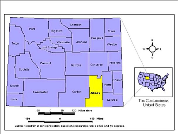
Albany County has an area of 4,290 square miles (11,111 km2) and is located in the southeastern corner Wyoming (Figure 1). The County has a population of approximately 32,000, with the majority of the population located in the city of Laramie (population 26,000). Private land accounts for 69.4% of the whole county and contains potential habitat for a number of candidate, threatened, and endangered species, particularly those found in lower elevations. A distribution of land ownership is provided in Table 1, illustrating the various groups and agencies potentially affected by this HCP process. Numerous land uses such as housing, recreation, ranching, farming, and mining occur throughout the county that may impact species habitats.
The regional climate is mostly characterized as a semiarid environment receiving an average of 12 to 16 inches (30.5 to 40.6 cm) of precipitation annually in the lower to middle elevations, however, some higher elevations in the County receive as much as 60 inches (152.4 cm) of mean annual precipitation (Knight, 1994). Surface water sources consist of small ponds and lakes, reservoirs, streams, and the Laramie River as the only major river located within the County. The region contains high plains, basins, foothills and mountains; with the foothills and mountains generally oriented in a north-south manner. The elevation range is from 7,000 to 11,000+ feet (2,133 to 3,352 meters) MSL. The annual precipitation, coupled with the topography supports a variety of vegetation types ranging from shortgrass prairie to subalpine meadows (Knight, 1994).
| Landowner | Square Miles | Acres | Percent of Total |
|---|---|---|---|
| U.S. Forest Service | 467 | 298,642 | 10.8 % |
| U.S. Fish and Wildlife | <1 | 354 | 0.01 % |
| U.S. Bureau of Land Management | 475 | 303,848 | 11 % |
| Wyoming Recreation Commission | <1 | 202 | 0.007 % |
| Wyoming Game and Fish | 10 | 6,330 | 0.23 % |
| State of Wyoming | 330 | 211,399 | 7.6 % |
| Albany County | <1 | 251 | 0.009 % |
| City | 5 | 2,970 | 0.01 % |
| School District | 25 | 15,872 | 0.57 % |
| Other | 11 | 7,267 | 0.26 % |
| Total Public | 1,324 | 847,135 | 30.6 % |
| Total Private | 2,997 | 1,918,305 | 69.4% |
| Water | 47 | 30,012 | 1.1 % |
Information on Albany County used to geographically characterize the area for use in the habitat models was obtained from a wide variety of government and non-government sources. Data was obtained from various clearinghouses such as the University of Wyoming's Spatial Data and Visualization Center, the United States Geological Survey, the United States Census Bureau, and the Wyoming Gap Analysis Project. The compiled information used to delineate habitats consists of elevations, floodplains, soil types, vegetation types, open water, geology types, and human settlement areas. Additional data such as watershed boundaries, roads, railroads, and land use were also obtained. The Albany County Assessors Office provided land ownership and parcel information for the City and County. This set of additional information will be used in conjunction with the identified specie's habitat to support decisions made by the County officials' in the HCP process.
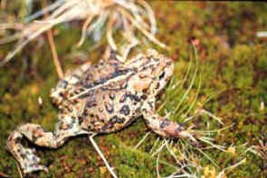
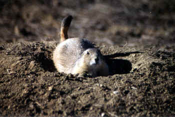
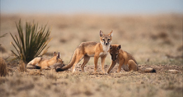
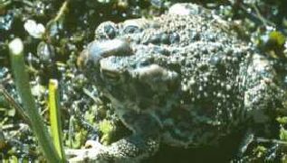
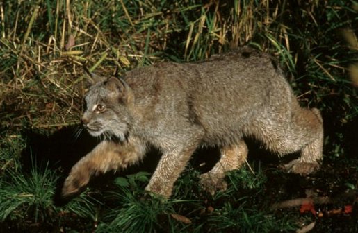
Seven species were identified as relevant species of concern to be included in the proposed HCP for Albany County (Table 2). Information on each animal's habitat criteria was obtained, and summarized in Table 3; the Wyoming Natural Diversity Database personnel and other experts subsequently verified this summary for accuracy. Table 3 provides the basis for classifying a preference or relationship to each attribute classification used when determining species' habitat. These preferences were incorporated into each model developed in ArcView's Spatial Analyst ModelBuilder extension to produce the potential habitats for the seven species of concern.
|
The Habitat Conservation Plan for Albany County, Wyoming will cover seven species in the county. The species, their status and approximate habitat areas are as follows: |
|
|
Determination of the actual suitable habitat within Albany County for each species was obtained through the use of ArcView GIS 3.2 software. Multiple attributes (topography, geology, soil, climate, vegetation, and hydrology) of the county were used to provide spatial data needed for identifying potential species habitat. The ModelBuilder extension of ArcView GIS 3.2 allows for the manipulation of several attributes to produce a ranked and weighted overlay of relevant data, producing potential habitat maps for the seven species of concern.
The ModelBuilder extension provides a user-friendly format for building spatial models. Model building Process Wizards and Diagramming Tools provide an interface in which the user can construct various types of spatial models. Each habitat model developed in ModelBuilder for this study is represented in a process flow diagram. These diagrams provide a visual means to construct, modify and document each habitat model. ModelBuilder also allows users to rerun the saved models using different input data, different function parameters, and different sets of values, thus enabling them to evaluate the end results as needed. This functionality may be especially important when new or revised applicable data/information becomes available for establishing the delineated habitats. Thus, Albany County officials will have the capabilities to incorporate additional information into the models to produce more precise habitat maps before the final HCP proposal is submitted.
| SPECIES | TOPOGRAPHY | GEOLOGY | SOILS | CLIMATIC | VEGETATION | HYDROLOGY | FLOODPLAIN | |
|---|---|---|---|---|---|---|---|---|
| Preble's Meadow Jumping Mouse | <8100' Elevation, Slope <3% and 1%> River Terrace and Foothills | Aeolian | Sandy Loam, no clay and no outcrop | < 32F min avg. for hibernation | Riparian, tall grasses shrubs, heavy understory, Willow, Chokecherry, Snowberry | Riparian-Buffer of 35M Streams (perennial or intermittent), Marshes, Irrigation Ditches | Within 100 Year and up to 100M outside 100Y floodplain | |
| Wyoming Toad | 7200'-7500' Elevation,<3% Slope, Laramie Basin | Aeolian | Mollisol(sandy wet soil),no outcrop and clay | <32 F avg. for hibernation,> 70F out of hibernation | Laustarian Cattail, grasses, wetland vegetation | Lakes, ponds and marshes <11' depth | n/a | |
| Mountain Plover | 2100-7800' Elevation, <9% Slope | n/a | "Usfoll" clay or dry loamy, near outcrops, no wet areas | - | Short grasses, overgrazed bare ground, open understory, fire disturbed areas. Blue Gramma, Buffalo Grass | No water needed, buffer area 100m inverse of water. | - | |
| Boreal Toad | 8000-11,900' Elevation | Oxbow Lakes | Wet soils, loose soil, sandy muddy silt. No outcrop set buffer at outcrop. | >32 F min. daily avg. Hibernate Sep-Apr. | Alpine boggy meadows, Spruce, Fir, Lodgepole Pine. Lower elevations, Willow, Sage, Ponderosa Pine. | Shallow pond edges, stream slides, boggy meadows | - | |
| Swift Fox | < 7800' Elevation, Den sites on E facing slopes near prairie dog towns | Alluvium | Sandy loam | n/a | Blue Stem Buffalo Grass, Wiregrass. Open, sparsely vegetated short-grass and mixed-grass prairie. Plains and shrubby desert areas away from extensively cultivated lands. | Riparian, sandy stream valley near permanent water bodies. | n/a | |
| Canada Lynx | <6400'-13,700' Elevation | Surface outcrop | Rock outcrop | Deep snow in winter | Dense forest, Spruce, heavy understory, Lodgepole Pine, diverse forest, old growth forest, high log density. Buffer with open space. Same habitat as Snowshoe Hare | - | - | |
| Black-tailed Prairie Dog | <7800' Elevation, <8% Slope | - | Lose, sandy soil, no wet area. | - | Short grass lands, areas with varied vegetation. | No water buffer, 100m inverse area. | - |
Each model developed in ModelBuilder utilized the habitat criteria listed in Table 3 to establish the parameters for the individual specie potential habitat. These models employed an equal-weighting scheme of the spatial attributes used. Thus each attribute layer contributed equally to the weighted overlay to produce a final habitat map. In addition, the ModelBuilder extension allows for a ranking of the individual variables within each attribute. For example, the elevation attribute contains categories/variables of several user defined elevation ranges. Each individual range can be assigned a value that indicates the relationship to the final output of the model.
A ranking system from 1-3 was employed to classify the variables within each attribute used in a habitat model. If the variable could be excluded by the habitat criteria outlined in Table 3, then that variable was classified as "restricted", thus excluding this variable for analysis in the model for the final habitat overlay. For example, Black-Tailed Prairie Dogs are not found in elevations above 7800 feet MSL (2377 meters). All elevations above this elevation were restricted from analysis, thus excluding such areas from being identified as potential habitat. A variable was ranked with a "1" if no relationship could be established but was not specifically excluded by the habitat criteria. A variable was ranked with a "2" if some incidental relationship could be established with the criteria. A variable was ranked with a "3" if a definitive relationship could be established with the criteria. This ranking system was used for each of the attribute variables used in a species model. The final habitat overlay maps produced for each species illustrated this ranked order of potential habitat. Delineated habitat ranked with a "3" represented locations with the highest potential using this system.
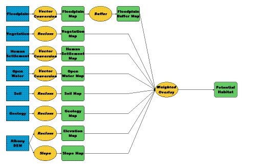
All seven of the Albany County listed species' potential habitats were identified using this process. Two generalized models were developed for the species of concern. The first generalized model was used to determine the potential habitats for the Preble's Meadow Jumping Mouse, the Black Tailed Prairie Dog, and the Mountain Plover. These species' models required a buffer around relevant attributes in determining their habitats. Figure 2 illustrates the model developed for the Preble's Meadow Jumping Mouse. The structure of this model is similar to the structure of the Mountain Plover and the Black-Tailed Prairie Dog models. The attribute classifications and their respective rankings for the Preble's Meadow Jumping Mouse are shown in Table 4. Table 4 demonstrates ModelBuilder's ability to rank, weight and incorporate multiple data sources to produce an overlay map; in this case a potential habitat overlay.
| Data Layer | Class Value | Attribute Label | Rank Score | Weight |
|---|---|---|---|---|
| Geology | Ai | Old Alluvial Plain | 2 | 12 |
| Lake | Lake | Restricted | ||
| Mi | Mesa | 1 | ||
| Ri | Bedrock | Restricted | ||
| ai | Alluvium | 2 | ||
| bdi | Dissected Bench | 1 | ||
| bi | Bench | 1 | ||
| ei | Eolian Mixed | 3 | ||
| fdi | Dissected Alluvial Fan | 2 | ||
| fi | Alluvial Fan | 1 | ||
| gi | Glacial Deposits | Restricted | ||
| li | Landslide Mixed | 1 | ||
| oai | Glacial Outwash | 1 | ||
| pea | Playa Deposits | 2 | ||
| ri | Residuum | 1 | ||
| sci | Slopewash and Colluvium | 1 | ||
| tdi | Dissected Terrace Deposits | 2 | ||
| ti | Terrace Deposits | 2 | ||
| tre | Shallow Terrace Deposits | 2 | ||
| ui | Grus | 1 | ||
| xi | Truncated Bedrock | 1 | ||
| No Data | No Data | Restricted | ||
| Slope | 0-5 | 0-5% | 3 | 12 |
| 5-10 | 5-10% | 1 | ||
| 10-90 | 10-90% | Restricted | ||
| No Data | No Data | Restricted | ||
| Soil Type | AL01 | Fluventic Haplaquolls | 2 | 12 |
| AL02 | Ustic Haplocambids | 2 | ||
| AL03 | Ustic Haplacalcids | 2 | ||
| AL04 | Ustic Haplargids | 2 | ||
| AL05 | Typic Haplogypsids | 3 | ||
| AL06 | Ustic Natrargids | 2 | ||
| AL07 | Ustic Haplargids | 2 | ||
| AL08 | Ustic Lithic Haplocalcids | Restricted | ||
| AL09 | Aridic Argiustolls | Restricted | ||
| AL10 | Ustic Haplargids | 1 | ||
| AL11 | Lithic Haplocryolls | Restricted | ||
| AL12 | Lithic Haplocryolls | Restricted | ||
| AL13 | Lithic Haplocryolls | Restricted | ||
| AL14 | Typic Dystrocryepts | 2 | ||
| AL15 | Lithic Cryorthents | Restricted | ||
| AL16 | Typic Dystrocryepts | Restricted | ||
| No Data | No Data | Restricted | ||
| Open Water | 11 | Open Water | Restricted | 13 |
| No Data | No Data | 1 | ||
| Human Settlement | 1 | Human Settlement | Restricted | 12 |
| No Data | No Data | 1 | ||
| PMJM Flood Buffer | 1 | 0-150 ft. | 3 | 13 |
| 2 | 150-300 ft. | 3 | ||
| 3 | 300-450 ft. | 3 | ||
| No Data | No Data | Restricted | ||
| Elevation | 1 | 5250-5975 ft. | 3 | 13 |
| 2 | 5976-6700 ft. | 3 | ||
| 3 | 6701-7450 ft. | 3 | ||
| 4 | 7451-8200 ft. | 3 | ||
| 5 | 8201-8950 ft. | 1 | ||
| 6 | 8951-9675 ft. | Restricted | ||
| 7 | 9676-10500 ft. | Restricted | ||
| 8 | 10501-11200 ft. | Restricted | ||
| 9 | 11201-11925 ft. | Restricted | ||
| No Data | No Data | Restricted | ||
| Vegetation | 11001 | Human Settlement | Restricted | 13 |
| 21001 | Dry-land Crops | 1 | ||
| 21002 | Irrigated Crops | 2 | ||
| 31001 | Mixed Grass Prairie | 3 | ||
| 32001 | Mesic Upland Shrub | 2 | ||
| 32002 | Xeric Upland Shrub | 1 | ||
| 32006 | Mountain Big Sage | 1 | ||
| 32007 | Wyoming Big Sage | 1 | ||
| 32008 | Black Sagebrush Steppe | 1 | ||
| 32010 | Desert Shrub | 1 | ||
| 32011 | Saltbrush Fans and Flats | 1 | ||
| 32012 | Greasewood Fans and Flats | 1 | ||
| 41001 | Aspen | 1 | ||
| 42001 | Spruce-Fir | 1 | ||
| 42004 | Lodgepole Pine | 1 | ||
| 42007 | Clearcut Conifer | 1 | ||
| 42009 | Limber Pine Woodland | 1 | ||
| 42010 | Ponderosa Pine | 1 | ||
| 42015 | Juniper Woodland | 1 | ||
| 52001 | Open Water | Restricted | ||
| 61001 | Forest Dominate Riparian | 2 | ||
| 62001 | Shrub Dominated Riparian | 3 | ||
| 62002 | Grass Dominated Wetland | 3 | ||
| 71001 | Unvegetated Playa | 1 | ||
| 74001 | Basin Exposed Rock/Soil | Restricted | ||
| 74002 | Alpine Exposed Rock/Soil | Restricted | ||
| 75001 | Surface Mining Operations | Restricted | ||
| 82002 | Subalpine Meadow | Restricted | ||
| No Data | No Data | Restricted |
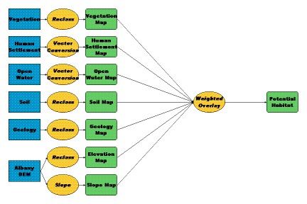
The second model illustrated by Figure 3, shows the model structure used for determining the potential habitats of the Swift Fox. This model is similar to the structure of the Canada Lynx, the Wyoming Toad, and the Boreal Toad models. These species do not require a buffer around any of the attributes used in this study and thus, is a slight variation to the model structure illustrated by the Preble's Meadow Jumping Mouse. Table 5 demonstrates the ranked classes of attributes used in the Swift Fox Model.
| Data Layer | Class Value | Attribute Label | Rank Score | Weight |
|---|---|---|---|---|
| Geology | Ai | Old Alluvial Plain | 3 | 14 |
| Lake | Lake | Restricted | ||
| Mi | Mesa | 1 | ||
| Ri | Bedrock | 1 | ||
| ai | Alluvium | 3 | ||
| bdi | Dissected Bench | 3 | ||
| bi | Bench | 1 | ||
| ei | Eolian Mixed | 1 | ||
| fdi | Dissected Alluvial Fan | 1 | ||
| fi | Alluvial Fan | 1 | ||
| gi | Glacial Deposits | 1 | ||
| li | Landslide Mixed | 1 | ||
| oai | Glacial Outwash | 2 | ||
| pea | Playa Deposits | 2 | ||
| ri | Residuum | 2 | ||
| sci | Slopewash and Colluvium | 1 | ||
| tdi | Dissected Terrace Deposits | 2 | ||
| ti | Terrace Deposits | 2 | ||
| tre | Shallow Terrace Deposits | 1 | ||
| ui | Grus | 2 | ||
| xi | Truncated Bedrock | 2 | ||
| No Data | No Data | Restricted | ||
| Slope | 0-15 | 0-15% | 3 | 14 |
| 15-20 | 15-20% | 2 | ||
| 20-25 | 20-25% | 1 | ||
| 25-90 | 25-90% | Restricted | ||
| No Data | No Data | Restricted | ||
| Soil Type | AL01 | Fluventic Haplaquolls | 3 | 14 |
| AL02 | Ustic Haplocambids | 3 | ||
| AL03 | Ustic Haplacalcids | 3 | ||
| AL04 | Ustic Haplargids | 1 | ||
| AL05 | Typic Haplogypsids | 1 | ||
| AL06 | Ustic Natrargids | 1 | ||
| AL07 | Ustic Haplargids | 1 | ||
| AL08 | Ustic Lithic Haplocalcids | 1 | ||
| AL09 | Aridic Argiustolls | 1 | ||
| AL10 | Ustic Haplargids | 1 | ||
| AL11 | Lithic Haplocryolls | 1 | ||
| AL12 | Lithic Haplocryolls | 1 | ||
| AL13 | Lithic Haplocryolls | 1 | ||
| AL14 | Typic Dystrocryepts | 3 | ||
| AL15 | Lithic Cryorthents | 3 | ||
| AL16 | Typic Dystrocryepts | 3 | ||
| No Data | No Data | Restricted | ||
| Open Water | 11 | Open Water | Restricted | 14 |
| No Data | No Data | 1 | ||
| Human Settlement | 1 | Human Settlement | Restricted | 14 |
| No Data | No Data | 1 | ||
| Elevation | 1 | 5250-5975 ft. | 3 | 15 |
| 2 | 5976-6700 ft. | 3 | ||
| 3 | 6701-7450 ft. | 3 | ||
| 4 | 7451-8200 ft. | 3 | ||
| 5 | 8201-8950 ft. | Restricted | ||
| 6 | 8951-9675 ft. | Restricted | ||
| 7 | 9676-10500 ft. | Restricted | ||
| 8 | 10501-11200 ft. | Restricted | ||
| 9 | 11201-11925 ft. | Restricted | ||
| No Data | No Data | Restricted | ||
| Vegetation | 11001 | Human Settlement | Restricted | 15 |
| 21001 | Dry-land Crops | 1 | ||
| 21002 | Irrigated Crops | Restricted | ||
| 31001 | Mixed Grass Prairie | 3 | ||
| 32001 | Mesic Upland Shrub | 2 | ||
| 32002 | Xeric Upland Shrub | 2 | ||
| 32006 | Mountain Big Sage | 3 | ||
| 32007 | Wyoming Big Sage | 3 | ||
| 32008 | Black Sagebrush Steppe | 3 | ||
| 32010 | Desert Shrub | 3 | ||
| 32011 | Saltbrush Fans and Flats | 1 | ||
| 32012 | Greasewood Fans and Flats | 1 | ||
| 41001 | Aspen | Restricted | ||
| 42001 | Spruce-Fir | Restricted | ||
| 42004 | Lodgepole Pine | Restricted | ||
| 42007 | Clearcut Conifer | Restricted | ||
| 42009 | Limber Pine Woodland | Restricted | ||
| 42010 | Ponderosa Pine | Restricted | ||
| 42015 | Juniper Woodland | 1 | ||
| 52001 | Open Water | Restricted | ||
| 61001 | Forest Dominate Riparian | Restricted | ||
| 62001 | Shrub Dominated Riparian | 1 | ||
| 62002 | Grass Dominated Wetland | 1 | ||
| 71001 | Unvegetated Playa | Restricted | ||
| 74001 | Basin Exposed Rock/Soil | 3 | ||
| 74002 | Alpine Exposed Rock/Soil | Restricted | ||
| 75001 | Surface Mining Operations | Restricted | ||
| 82002 | Subalpine Meadow | Restricted | ||
| No Data | No Data | Restricted |
The potential habitat overlay maps generated from each species model was subject to the same grid cell characteristic and coordinate system configuration standards. These standards are largely dependent upon the relevant data sources used in this habitat analysis and the appropriate level of resolution achieved by such sources. For this reason, the overlay maps used the configuration and appropriate resolution achieved from the 90M Digital Elevation Model (DEM). Therefore, all of the overlay maps outputs of the species potential habitats are extended to the grid theme of the Albany County DEM.
The elevation and slope themes were generated from the DEM of the county for use in species' habitat models. Geology, soil type, vegetation cover, open water, human settlements, and floodplain themes were also used in the habitat models. The geology theme classification codes were reclassified by using the given s-values codes (a number that is used to identify geology type/name) to reclassify to their respective classification names. The soil theme classification codes were also reclassified using this method. Vegetation theme classification codes were reclassified by using the given Wyoming Gap Analysis land cover codes to their respective land cover descriptions (Merrill and Others, 1996).
In addition, the Albany County Government uses the State Plane coordinate system (State Plane, NAD 1983,Wyoming East) for most of their mapping applications and regulatory functions, therefore all of the themes and outputs of this project were conducted in this coordinate system as a matter of convention. All relevant Metric data measurements (meters) were appropriately converted into English measurements (feet) to be consistent with the State Plane standards.
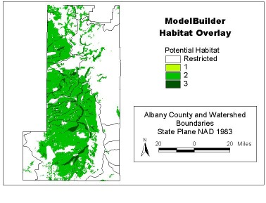
Figure 4 illustrates the ModelBuilder-generated potential habitat overlay of the Preble's Meadow Jumping Mouse (PMJM) within Albany County. The PMJM potential habitat overlay demonstrates the ability of this software to identify specific habitats using multiple criteria and data sets. With the use of the PMJM model, potential habitat can be identified and located. The potential habitat for the mouse is identified within the County and is ranked from 1 to 3 as established by the user-defined model parameters using the previously discussed methods. The potential habitat areas associated with the number "3" represent areas with the greatest habitat potential. Areas identified with a "2" and a "1" represent habitat locations with less potential (respectively). Areas restricted from analysis are illustrated by the "restricted" classification. Delineated habitat for the PMJM coincides with the generalized area estimated in Table 2. This habitat theme therefore demonstrates how this information could be used to identify specific areas needed for conservation as required by the Endangered Species Act and for the development of a Habitat Conservation Plan.
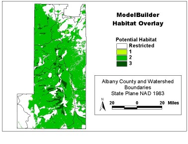
The potential habitat overlay of the Swift Fox is illustrated in Figure 5. As with the PMJM, the Swift Fox's potential habitat overlay produced information to aid in the location of specific habitat needed by this specie. A similar representation scheme from 1 to 3 was used to illustrate the potential habitat of the Swift Fox. Areas classified with a "3" possess the greatest potential, then followed by a "2" classification, a "1" classification, and a "restricted" classification for areas with the least potential. As with the Preble's Meadow Jumping Mouse, the results coincide with the USFWS general descriptions as to where the Swift Fox's habitat is within the County (Table 2).
All seven of the species investigated in this study produced delineated locations of potential habitat within Albany County. Each of the seven species has a specific habitat model developed in ModelBuilder to estimate their respective habitats. This information provides a more detailed account of what areas/locations need to be protected under a HCP. The estimated habitat locations for all seven of the species do not differ from the generalized descriptions provided by the USFWS. Therefore, the ModelBuilder extension provided the ability to delineate species' specific habitats needed by County officials to aid in the development of a HCP.
The University of Wyoming Planning Program's goal to provide sufficient habitat background information to the Albany County Commissioners and to the Albany County Planner was achieved with the use of ArcView GIS 3.2 software. This software application enabled the user to incorporate multiple sources of information to create a single overlay of relevant data with the use of the Spatial Analysts' ModelBuilder extension. This extension allows for the development of complex species specific habitat models used for locating threatened and endangered species potential habitats. These models generated applicable maps and information to be used for the development of a countywide Habitat Conservation Plan.
By combining the results of the predicted habitats for each species investigated in this study with additional data themes, such as land ownership, new information may be generated for the HCP-based proposal process. This information may allow for the identification of possible conflicts associated with the land conservation measures required under the ESA. Subsequently the HCP process could then mitigate these conflicts. With this identification process, Albany County officials will have the means to assist in the policy decisions used to protect required habitat areas, as well as the means to develop a HCP. The database used for this research was obtained from an Environmental Planning class exercise, at the University of Wyoming. This exercise produced a coarse filter or "broad brush" database to be used for delineating habitat. The results produced using this database should not replace on-the-ground survey for site specific management strategies, and therefore would require more detailed study.
More importantly, the results of this study illustrates how complex habitat models developed in ModelBuilder produced a single overlay map of ranked potential habitat for each species. The habitat models developed in ModelBuilder may be modified, as more/new data becomes available. This software also enables the user to change the values of the weights and ranks, thus adjusting the models for any corrections or changes needed.
ArcView Spatial Analysts' Model Builder can utilize updated attribute data used in a species' habitat model, thus enabling the user to access current information in order to produce up-to-date potential habitat maps. This GIS based approach will allow for Albany County officials to incorporate the established species habitat criteria, current land use information, current species data, and local geographical attributes into a specific species' model to produce habitat maps needed for the development of a Habitat Conservation Plan.