The City of Buffalo: a great attraction place for tourists
The City of Buffalo: a great attraction place for tourists
Keywords: Recreational bikeway network, GIS, ArcView, Arc Info, TransCAD
INTRODUCTION
Walking and bicycling are two of the most important indicators of a livable community. Bicycle is a non-polluting, noiseless, and energy efficient form of transportation. Bicycling offers not only the most inexpensive means of travel next to walking but also promotes physical and recreational activities. In addition, a comprehensive bikeway network can provide a significant impact on local and regional tourism. Unfortunately, city residents, such as those in Buffalo, NY, often cannot use biking as recreational activity or as alternative
mode of transportation. Some of the reasons might be the inefficient or incomplete network, lack of infrastructure and maintenance, presence of threats such as fatalities and injuries, and lack of support services (i.e. bike racks). Nevertheless, the fact is that Buffalo could easily be a major attraction place for bicyclists with its flat terrain, rich historical, architectural and cultural assets, citywide park system, attractive natural scenarios, ethnic neighborhoods, and close proximity of street network.
The objective of this project is to develop a GIS based model for designing a bikeway network, mainly for recreation and tourism, for Buffalo and to develop an interactive web site for that network. Bicycle network design or bicycle facility planning is associated with a variety of fields, such as transportation, environment, engineering, landscape, health, tourism, and so on. This project has focused mainly on planning and design issues.
This project would inform community people about the benefits that they might get from the implementation of such a project in this city. It will try to enhance, contribute, and fortify the recent movements towards bicycle plan and facilities development in this city. In addition, the project will promote the assets of Buffalo and inform local people and tourists the facilities and attractions they might have throughout those bike routes.
The project has been designed in such a way that it will complement the existing Bicycle Master Plan of the Greater Buffalo-Niagara Regional Transportation Council (GBNRTC), the local Metropolitan Planning Organization (MPO), and some other existing bikeway and greenway proposals of the city.
BACKGROUND
Factors that affect the selection of bikeways
In general there are two types of bicycling; one is recreational bicycling and the other one is daily life bicycling, which includes journey to work, journey to school, and journey to convenience stores. The factors that affect the selection of bikeways are also different for these two types of bikeways. In cities or metropolitan areas, the recreational potential of bikeways or greenway trails is usually underscored because of the unavailability and the high cost of large tracts of open land. In such cases, greenways have been identified in the form of stream corridors, street boulevards, and abandoned railway corridors. These are considered as the public open spaces of the next generation (Little, 1990; Porter and Hastings, 1991).
While designing a bikeway or greenway, the factors should be chosen if they could provide ecological, recreational, and cultural benefits to a community (Ndubisi et al., 1995). Since this project is dealing with citywide recreational bikeways, the discussion will be basically focused on the attributes that are important only for such type of bikeways.
Assessment of the visual resource is a key element in environmental planning (Brown, 1994). Different studies on travelers' motivations have shown that along with rest and recreation, visiting scenic areas and historic sites are among the top reasons why people travel. Again, the value of tourist routes and outdoor recreation areas depend on their visual qualities (Bishop and Gimblett, 2000, p. 425). In Chicago metropolitan region, 2873 numbers of trail users were surveyed in 1990 in order to be acquainted with their preferences about those trails (Gobster, 1995). In the field of natural environment, the users liked "scenic beauty", "nature", "trees", "water bodies", and "hills and rolling topography". Another survey was done with 177 individuals to compare preferences for different types of landscapes in Mansfield, CU. The result showed that four out of five most preferred sites contained "water" (Kent and Elliott, 1995). Some of the attributes, which are considered for recreational bikeways, are discussed here.
Water feature is one of the most important features that can attract bikers. The fresh air, the scenario, and the linear path are rich attributes of recreational biking. A bikeway connecting different types of water features, such as rivers, lakes, creeks, water bodies, wadding pools, and canals can act like a 'linear park', which eventually might link the parks and parkways. Such a network will consist of both off-road bike paths or trails and on-road bike lanes (Mistretta and Wooster, 2001). It is also true that a waterfront should belong to the people and an accessible space at the water's edge is an important part of waterfront development, which provides the pedestrians, bicyclists, joggers, skaters, and others with a sense of ownership (Mistretta and Wooster, 2001).
"High quality parks are one of the most important contributors to eco-heritage and cultural tourism" (Buffalo Olmsted Parks Conservancy, 2001). Usually parks have the following features: scenic beauty, green spaces, trees, water bodies, and recreational facilities, all of those are considered attractive to recreational bikers. Bicycle trails today are considered as major recreational facility development for many parks and forest preserve districts (Gobster, 1995). Small loop trails through existing parks and neighborhoods might be more useful and less cost effective than long-distance trails (Gobster, 1995). The facilities of parks and recreational activity in a neighborhood can induce consumer spending by encouraging street life activities and public events (UB Graduate Planning Students, 2001, p. 3). Consequently it can increase property values and have an impact on neighbor vitality and economic development (Weicher and Zerbst, 1973).
Following the national trend, the abandoned railroads all over the United States are being converted to trails and thus linked with different parts of the cities by connecting different neighborhoods (Rails to Trails Conservancy web site, 2001). These railroads provide linear corridors that can be easily converted into tails or greenways by protecting and connecting landscapes of particular ecological, recreational, and aesthetic value (Little, 1990; Hay, 1991; Soule, 1991). Usually these railroads can offer beauty of nature, as those pass through the natural environment, not man made one. All the industrial cities of the early twentieth century have number of abandoned railroad corridors, which are owned by different public and private organizations. These vacant linear plots could be developed as trails, which can offer recreation as well as short-cut access to different neighborhoods. According to Rails-to-Trails Conservancy (RTC), around 1090 trails of 11,582 miles have been constructed from abandoned railroads all over the USA up to September 2000 (Rails to Trails Conservancy web site, 2001). These trails designated as National Recreational Trails (NRT) were constructed on federal, state, local and privately owned lands and are available for public use.
A scenic bikeway not only offers natural beauty but also cultural and historical values with the glimpses of history, geology, landscaping, and cultural activities (US Department of Transportation, 1998, p. 1). The architectural, cultural, and historical places of a city can always be a great attraction to the tourists as well as the local people. For example, the "cultural components characteristic of the New England landscape, like agricultural uses and historic structures, contributed to scenic value as much as natural features" (Kent and Elliott, 1995, p. 342). A bikeway network can provide bikers the opportunity to travel citywide attraction places. However, management of such areas that are culturally and ecologically sensitive requires knowledge and management of recreationists' behavior (Bishop and Gimblett, 2000, p. 423).
The consideration of public transit network, such as the bus route or underground railroad, is important while designing the citywide bikeway network, especially if the mass transportation service provides bike racks or bicycle carrying facilities. Location and connectivity are two of the most important factors for local trails. Trails should be reached from a distance of maximum five miles for younger people, and one mile for older people with the age group of 55+ (Gobster, 1991). To avoid the lack of connectivity and continuity within the existing system, it is recommended to expand the existing network by linking local, regional, and national trails (Gobster, 1995, p.402).
As we already know, people's preference should be the main concern for designing on-road and off-road bike paths or trails. In the field of trail condition, the Chicago metropolitan region people preferred "smooth trail surface", "personal safety", "being away from cars and traffic", "crowding", and "closeness to home". Some of the negative attributes were "rough trail surface and path holes", "numerous street crossing", "dangerous road intersections", "too short", "too narrow", etc (Gobster, 1995). After designing a bikeway network the study of Traffic volume and Bicycle Level of Service (BLOS) should be important in order to identify the bicycling 'degree of difficulty' along the network.
Use of GIS and other methods in contemporary bikeway planning
"GIS is increasingly used in site assessment for many kinds of activity: urban development, ecological modeling, agricultural suitability, etc" (Bishop and Gimblett, 2000, p. 423). In recent years, a number of Metropolitan Planning Organizations (MPOs) and other public and private organizations are using GIS in preparing bicycle master plans as GIS is extremely powerful tool for data analysis, management, and presentation, and it can reduce the level of effort and time (Milam and Jones, 1995). However, it is unfortunate that GIS has been usually used for mapping, analyzing, site selecting, or forecasting the demand for bikeways, not as a tool or method for designing those.
GIS is a cost-effective way of locating and identifying bikeways and their associated assets (Spatial Queensland web site, 2001). For designing bikeway network, at first the major generators and destinations for bicycle traffic should be mapped. In addition roadway data such as traffic volume, lane and shoulder width, and speed limit can be analyzed in order to determine the suitability of roads for providing on-street bike lanes. Public lands, railroads and utility corridors can be evaluated to determine the suitability of constructing off-road bike path (Franklin Township Bikeway Master Plan web site, 2001).
Suitability analysis is one of the most commonly used GIS functions, which might be used in bikeway planning. It selects the criteria, assigns weights, incorporates new parameters, performs overlays and queries, and generates alternative scenarios (Whitley et al., 1993; Monmonier, 1995).
Spatial analysis, another major function of GIS, can be used to enhance bicycle demand forecasting and facility analysis (Federal Highway Administration, 1998). It is relatively difficult to design bikeways in a large and older city. In crowded areas of such cities, where linear greenway is "difficult to develop", a number of "small loop trails through existing parks and neighborhoods might be more useful � and would be more cost effective" (Gobster, 1995, p. 409).
GIS can be extremely helpful for evaluating the primarily designed bikeways. Utilizing the Delphi technique, the researchers can use Internet to coordinate expert panelist response and assign penalty values to each segment of the network. Then GIS can be used to calculate the composite score, which is called bicycle condition index (BCI). In Ames, IA, such a project was done where the researchers did visual inspection and made necessary changes for variable weighting based on bicyclist route preferences. The optimal routes scored better than the existing ones (Mescher and Souleyrette, 1996).
GIS plays important role for maintaining bikeways. It is easy to use aerial photography for mapping the sections of bikeways but difficult to acquire information such as features, hazards, and bikeway conditions. In such a situation, a vehicle mounted GPS unit might be the most suitable and economical way to map bikeways with accuracy and detail and to collect data, which consisted of links, sections, and condition (Spatial Queensland web site, 2001).
The recreational behavior can be studied by combining GIS with a spatially explicit agent modeling (Bishop and Gimblett, 2000, p. 429). Although GIS can calculate a viewshed in most conditions, it is not equipped with complex built form. In some cases the built form should be modeled with greater complexity with the help of CAD structure. Using 3-D graphics card, a hardware based rendering algorithm can do rapid visual assessment and thus allow the users judge visual quality more effectively (Bishop and Gimblett, 2000, p. 429).
An abiotic-biotic-cultural (ABC) strategy can assess environmentally sensitive areas (ESAs) and connect those by greenways (Ndubisi et al., 1995). In such case, the abiotic (e.g. physiography and soils), biotic (e.g. flora and fauna), and cultural (e.g. changes in human activities) phenomena have to be examined. A biotic significance map was prepared in Walton County, GA, by taking layers of wetlands, rock outcrop communities, water bodies, forest, and forest linkage corridors. However, such type of study needs "substantial outlay of time, funds, and skilled manpower" (Ndubisi et al., 1995, p. 166).
METHODOLOGY
Figure 1 shows the design or analysis procedure of this project, which is divided into three broad categories: (i) assessment of recreational bikeway attractions in Buffalo; (ii) construction of digital database; and (iii) GIS-based bikeway design. Descriptions of these steps are provided here.
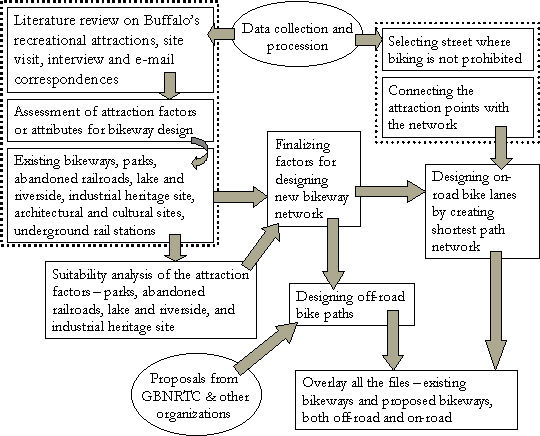
FIG. 1: Flow chart of the study methodology
Qualitative assessment of recreational bikeway attractions in Buffalo
In order to assess the bikeway attractions and other attributes of Buffalo, the following steps have been taken: literature review on Buffalo's history and tourism; interview and e-mail correspondences with bikers and tourists; and site visit to different natural and tourist attraction places.
As an important member of the Great Lakes Region, Buffalo can offer the bikers the views of her waterfront, the inner and outer harbors, the Erie Lake, the Niagara River, the Locks at Niagara River, the Buffalo River, the Times Beach, and the Erie Basin Marina. In addition, the Cazenovia Creek, the Sqajaquada Creek, and number of water bodies or lakes in different parks, especially in the Delaware Park, Tifft Farm and South Park, can meet the visual thirst of the communities as well as the tourists.
Buffalo's parks and parkway system was designed by the famous Frederick Olmsted and his firm between 1868 and 1898 (Beveridge, 1999, p. 15). Olmsted grafted the parkway system onto the original radial street plan of Joseph Ellicott, and believed that it made Buffalo the best-planned city in the United State in terms of its streets, public places, and grounds (Beveridge, 1999, p. 19). He planned for an integrated citywide park system, which is connected by artery like boulevards and parkways. Thus it can be said that biking in Buffalo's parks is not only a recreational experience but also an experience of exploring the history.
The "Queen City" Buffalo should recognize and promote her numerous historical assets in order to achieve economic development. Over the one hundred and fifty years of history, Buffalo has been evolved as an extraordinary architectural museum. "Its (Buffalo's) buildings and public spaces are among the best in the country, yet its place in the American architecture has seldom been recognized" (Clarkson, 1999, p. xiii). Buffalo Downtown has very interesting and historical street layout (The Niagara Square), the Theater District, waterfront, a number of outstanding architectural pieces from different styles and ages, and from the architects like Richardson, Sullivan, Burnham, Write, Upjohn, Albert Kahn, and Greene. In some areas like Allentown, Linwood Avenue, or Hamlin Park, lots of historical residences of different architectural styles are worth watching.
Buffalo not only has the architectural but also the historical heritage, especially the locks, the grain elevators, and the hundred years old steel factories. Buffalo's grain elevator, the one that is located near Erie Basin Marina, was the first in the world. Even now, the city has the largest collection of grain elevators in this continent and these are located on a 2� mile area along Buffalo Waterfront adjacent to Downtown.
Like all the industrial cities of the early twentieth century, Buffalo has a number of abandoned railroad corridors, which are owned by different public and private organizations. These vacant linear plots can be developed as trails, which can offer recreation as well as short-cut access to different neighborhoods.
The USGS Digital Elevation Model shows that topologically Buffalo is a flat area (Batty and Howes, 1995). This feature of Buffalo can be a major incentive to the medium to beginner bikers, not to mention the highly experienced bikers. That is why the consideration of this factor for the city of Buffalo might not a mandatory one. However, it should be a must for other cities with significant changes in elevation.
Buffalo metro rail service allows bikers to carry bicycles through the rail cars. However, unlike some other cities of the USA, the public buses of Buffalo do not provide bike racks. That is why only the metro rail stations have been considered as factors for designing bikeways.
The Digital Data
Data were collected from different sources. The major steps used for data processing include projection changing, digitizing, geocoding, and geoprocessing. The coordinate system used in the whole project is North American Datum (NAD) 1983 New York West (State Plane 1983).
To get the Buffalo outline shape file, the census tract data was downloaded from Esri ArcData Online. The polygons of all the tracts were dissolved by using the ArcView command - 'dissolve feature based on an attribute' and thus the outline was created. The water body and river files were also downloaded from Esri ArcData Online. The land use of 1998 shape file was obtained from the tax assessment data of the City Hall of Buffalo. The street file of the Erie County was obtained from CUGIR web site. Then only the streets of Buffalo were clipped using ArcView's Geoprocessing Wizard. The projection was changed for all of these shape files from Geographic (Latitude-Longitude) to State Plane 1983.
Existing bikeways of both on-road and off-road were digitized from the paper maps obtained from GBNRTC and then projected to State Plane 1983. The data of metro rail stations was downloaded from Niagara Frontier Transportation Authority (NFTA) web page. The data of important cultural and architectural places were taken from yahoo yellow page and the 'Friends of Buffalo'. Geocoding of all these data with street file were done.
The railroad data of the Buffalo - Niagara Region was collected from the Greater Buffalo-Niagara Regional Transportation Council (GBNRTC), the Metropolitan Planning Organization (MPO) of this region. By using the ArcView command 'theme select by theme', the railroads of the City of Buffalo were selected from the file. Projection was changed from NAD UTM, zone 18 to State Plane 1983. From the railroad data, the abandoned railroads were selected and a new data layer was created. From ArcView's 'select by theme', the parcels that completely contained the abandoned rail tracks were selected and converted to a new land use shape file. Again, from the original land use file, the parcels of parks, recreation, and sports facilities have been selected and converted into new file. Another file of the industrial sites was created in the same way.
GIS-based bikeway design
(1) GRID & Suitability Analysis - selecting factors for designing recreational bikeways
In order to find out the suitable attraction places for recreational biking in Buffalo, four polygon layers were chosen: parks, recreation and sports facilities; abandoned railroads; lake and river side; and industrial sites. Since bikers will bike besides the river, a buffer has been taken around 500 miles of the river and water bodies. At first these polygon layers were converted into GRID in Arc Info 8.0.2. Then individual ranking was assigned for all the layers. For parks and recreation layer, the state/county parks and Olmsted Parks have been ranked as the highest attraction. For abandoned railroad and lake and riverside layer, the vacant parcels and recreationally feasible parcels have been ranked as the highest. For industrial site layer, historically significant and tourist attraction industries have been ranked as the highest. After assigning the ranking of all of the four layers, those layers were overlaid. In the final grid, each layer has been equally weighted, as all of them are considered
equally important for recreational biking.
(2) Merging polygon layers with point and line layers
After the suitability analysis, the GRID has been converted as polygon again and then merged with the line and point files, including architectural and cultural attraction sites; metro rail stations; and existing bikeways, with the help of ArcView's Geoprocessing Wizard.
(3) Separating areas where bikeways are already designed or implemented
After getting all of the attraction layers together along with the existing bikeways, the areas of concentration for designing new bikeways were selected by excluding portions of the existing bikeways. Then the attraction features have been divided into two major groups: (i) For on-road bike lanes - parks, architectural & cultural sites, metro stations; and (ii) For off-road paths - lake & riverside, and industrial heritage sites.
(4) Designing off-road bike paths or trails using AutoCAD Map 2000
This phase was the most time consuming one because it is not totally GIS but a design problem as well. Since AutoCAD Map has been chosen as GIS/ landscape design software for this project, a conversion of the shape files (shp) into dxf format was necessary. While designing, the design proposals from GBNRTC & other organizations were carefully considered. Buffalo aerial map and land use pattern was also considered to find out the suitable land use such as vacant plot, recreational, public service, parks and other attractions. After designing the paths, those were converted again in ArcView shape file format.
(5) Designing on-road bike lanes - network analysis with TransCAD
In this stage all the shape files were converted as Standard Geographic (dbd) files in order to use those in TransCAD. Then all the polygon files were converted into point files.
In TransCAD, the major work was based on the street file. Following the information of GBNRTC, the streets where bicycling is not prohibited were selected. Then a network was created with that street file and all the point files and polygon centroids were added to that network. Then network analysis was done to find out the shortest paths from 'many to many' situations.
After getting the primary network, the segments that have problems like congestion, higher accident record, and poor bicycle level of service (BLOS) were reconsidered. Wherever possible, alternative segments have been added to the network. Streets like Main Street, Niagara Street, etc have been considered in the network even though they have some of the problems mentioned above. These streets are the major links in this network and also offer varieties of facilities or attractions to bikers.
(6) Overlaying proposed design with existing one
After designing the off-road and on-road bikeways, all the files were overlaid to get the final network.
RESULTS AND DISCUSSIONS
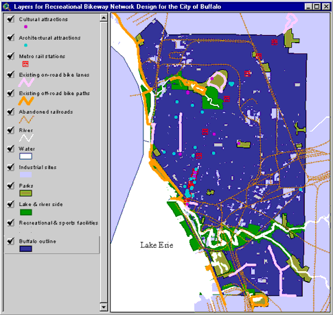
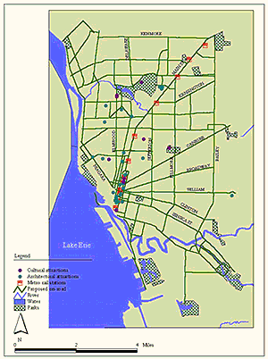
FIG. 2: Layers used for the project
Figure 2 shows all the layers used in this project while figure
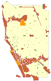
3 presents the result of the suitability study. The areas of the darkest color (maroon) are the most attractive sites for the bikers. This map highlights all the major parks of Buffalo, historically important industrial areas, abandoned railroad corridors that are feasible for conversion to bikeways, and the areas besides lake, river and creek. If we compare this with the original abandoned railroad file, we will observe that a significant portion was not considered here as feasible for converting bikeways. The discussion with Tim Trabold, Transportation Analyst of GBNRTC, and Bill Durfee, President of Greater Buffalo-Niagara Pedestrian and Bicycle Coalition helped to assess the feasibility rankings of the abandoned railroads.
 |
 |
|
FIG. 3: Suitability study |
FIG. 4: Conceptual network |
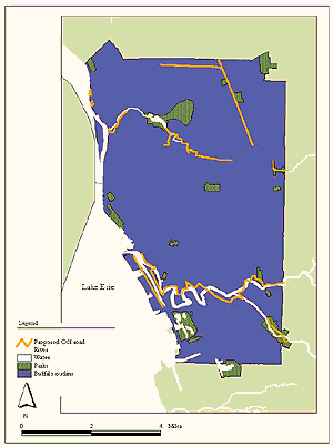
Figure 4 shows all the polygon, line and point layers together after the overlaying was done. The sites that should be considered for designing are marked here along with some arrow sign. Here the areas with the existing bikeways have been separated from the rest.
Figure 5 shows the proposed off-road bike paths or trails, which run through the industrial heritage sites; and besides the lake and river. Because of time constraint and unavailability of data, this remains as a preliminary design, not a detailed one. For more detail design, the vegetation, trees, wetlands, slope, and other constraints or benefits might be considered before designing.
 |
 |
|
FIG. 5: On-road bike lanes |
FIG. 6: Off-road bike paths |
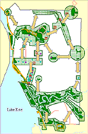
Figure 6 shows the proposed on-road bike lanes. In future, one needs to go through segment-by-segment of the primary network to focus on different planning issues related to on-road bikeway design. Figure 7 shows the final result, which is the combined proposed bikeway network along with the existing one.
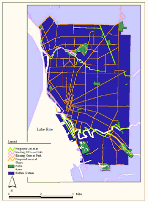
FIG. 7: Final network
DEVELOPMENT OF INTERACTIVE WEB SITE
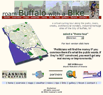
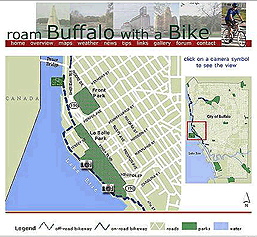
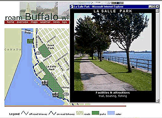
An interactive web site is on the way to develop based on the proposed as well as the existing bikeway network of Buffalo.Five main themes have been selected for the web site. These themes are: park to park, besides the river, abandoned rail track, historical and architectural tour. Around 300 pictures have been taken throughout different attractive places of Buffalo. All the maps are clickable to see the attractive scenarios of Buffalo throughout those bikeways.
CONCLUSION AND FUTURE WORK
This project has tried to develop a GIS-based model to design a recreational bikeway network for the City of Buffalo. It has blended GIS technology with Urban Planning and Landscape Design. The implication of this project is to provide useful information and to describe detail methodology so that other communities might develop such a project by following similar procedures. Although the project has been developed only by following the issues or criteria of Buffalo, the procedures might be used successfully for other cities as well by adding or subtracting some of the criteria.
The major phase missed in this project was the critical revision of the whole procedure or some portions of it. Because of time constraint it was not possible to revise the primarily proposed network for further
analysis.
Future works for this project should include: (i) the consideration of vegetation, trees, wetlands, and slope for a more detail off-road design; (ii) going through segment-by-segment of the primary network to face different planning issues; (iii) studying the degree of difficulty of the network for the bikers; and (iv) 3D simulation and landscape design inside the parks. After going through these stages, if any problem arises with a particular segment of the primary network, the designer might have to look for alternative segments and redesign the
network.
REFERENCES
Batty, M., Howes, M. (1995). The Buffalo Project. http://www.geog.buffalo.edu/Geo666/batty/buffalo.html (April 22, 2001).
Beveridge, Charles. (1999). Buffalo's Park and Parkway System. In Buffalo Architecture: A Guide (p. 15-23). Cambridge, MA: The MIT Press.
Bishop, I. D., & Gimblett, H. R. (2000). Management of recreational areas: GIS, autonomous agents, and virtual reality. Environment and Planning B: Planning and Design 27 (3): 423-435.
Brown, T. (1994). Conceptualizing smoothness and density as landscape elements in visual resource management. Landscape and Urban Planning 30: 49-58. Quoted in Bishop, I. D., & Gimblett, H. R. (2000). Management of recreational areas: GIS, autonomous agents, and virtual reality. Environment and Planning B: Planning and Design 27 (3): 423-435.
Cornell University Geospatial Information Repository (CUGIR). http://cugir.mannlib.cornell.edu (May 1, 2001).
Clarkson, William. (1999). Preface. Buffalo Architecture: A Guide (pp. xii-xiii). Cambridge, MA: The MIT Press.
Franklin Township Bikeway Master Plan. http://www.orth-rodgers.com. (March 8, 2001).
Gobster, Paul H. (1995). Perception and use of a metropolitan greenway system for recreation. Landscape and Urban Planning 33(1-3): 401-413.
------------, (1991). Trends in urban forest recreation: trail use patterns and perceptions of older adults. In Proceedings of the National Outdoor Recreation Trends Symposium III, (p. 29-31), March 1990, Indianapolis, IN: Indiana University - Purdue University. As quoted in Gobster, Paul H. (1995). Perception and use of a metropolitan greenway system for recreation. Landscape and Urban Planning 33(1-3): 401-413.
Hay, K. G. (1991). Greenways and biodiversity. In W. E. Hudson (Ed.). Landscape Linkages and Biodiversity. Washington, D.C.: Defenders of Wildlife. As quoted in Gobster, Paul H. (1995). Perception and use of a metropolitan greenway system for recreation. Landscape and Urban Planning 33(1-3): 401-413.
Kent, Richards L., & Elliott, Cynthia L. (1995). Scenic routes linking and protecting natural and cultural landscape features: a greenway skeleton. Landscape and Urban Planning 33 (1-3): 341-355.
Little, C. E. (1990). Greenways for America (p. 237). Baltimore, MD: John Hopkins University Press. As quoted in Gobster, Paul H. (1995). Perception and use of a metropolitan greenway system for recreation. Landscape and Urban Planning 33(1-3): 401-413.
Mescher, Phillip J. Souleyrette, Reginald R. (1996). Use of an Internet-Based Delphi Techniques and Geographical Information System for Bicycle Facility Planning. Paper written for the 1996 Geographic Information System for Transportation Symposium, 1996. Quoted in Federal Highway Administration. (1998). Milam, Ronald and Jones, Michael. (1995). Engineering a Bikeway Master Plan. Prepared for the 1995 ITE District 6 Annual Meeting. Denver, CO.
Mistretta, M. and Wooster, Margaret. (2001). The Buffalo Waterfront Greenway System.
Monmonier, M. (1995). A case study in the misuse of GIS: Siting a low level radioactive waste disposal facility in New York State. In Law and Information Policy for Spatial Database (p. 293-303). Ed. H.J. Onsrud. Quoted in Esnard, Ann-Margaret and MacDougall, E. Bruce. (1997). Common Ground for Integrating Planning Theory and GIS Topics. Journal of Planning Education and Research 17 (1): 55-62.
Niagara Frontier Transportation Authority (NFTA). http://www.nfta.com/metro. (May 1, 2001).
Ndubisi, Forster, DeMeo, Terry, & Ditto, Neils D. (1995). Environmentally sensitive areas: a template for developing greenway corridors. Landscape and Urban Planning 33 (1-3): 159-177.
Porter, E. and Hastings, W. (1991). Metropolitan greenways: green connections for urban areas. Trends 28 (4): 14-17. As quoted in Gobster, Paul H. (1995). Perception and use of a metropolitan greenway system for recreation. Landscape and Urban Planning 33(1-3): 401-413.
Rails to Trails Conservancy. http://www.railtrails.org/ (March 11, 2001).
Soule, M. E. (1991). Land use planning and wildlife maintenance: guidelines for conserving wildlife in an urban landscape. Journal of American Planning Association 57: 313-323. As quoted in Gobster, Paul H. (1995). Perception and use of a metropolitan greenway system for recreation. Landscape and Urban Planning 33(1-3): 401-413.
Spatial Queensland, http://www.surveying-qld.org.au/public/ (March 9, 2001).
US Department of Transportation. (1998). Scenic Byways. Washington, D.C.: US Department of Transportation.
Whitley, D. L., Xiang, W., & Young, J. J. (1993). Use a GIS "melting pot" to assess land use suitability. GIS World 6 (7): 48-52. Quoted in Esnard, Ann-Margaret and MacDougall, E. Bruce. (1997). Common Ground for Integrating Planning Theory and GIS Topics. Journal of Planning Education and Research 17 (1): 55-62.
ACKNOWLEDGEMENTS
Bian, Ling, Associate Professor, Department of Geography, University at Buffalo, State University of New York, Buffalo, NY.
Durfee, Bill, President, Greater Buffalo-Niagara Bicycle and Pedestrian Coalition, Buffalo, NY.
Krasner, Michael, Senior Planner, Erie County Department of Environment and Planning, Buffalo, NY.
Mann, Howard J., New York City Department of Transportation, NY.
McLean, Beverly M., Senior Research Associate, Center for Urban Studies, University at Buffalo, State University of New York, Buffalo, NY.
Meloney, Dennis, Parks Coordinator, Buffalo Urban Renewal Agency, Department of Public Works, The city of Buffalo, NY.
Page, G. William, Professor, Department of Planning, University at Buffalo, State University of New York, Buffalo, NY.
Thill, Jean-Claude, Professor, Department of Geography, University at Buffalo, State University of New York, Buffalo, NY.
Trabold, Timothy, Senior Transportation Planner, Greater Buffalo-Niagara Regional Transportation Council, Buffalo, NY.
AUTHOR INFORMATION
Md. Mahbubur Rabb Meenar
Graduate Assistant
Institute for Local Governance and Regional Growth
Research Assistant
Center for Urban Studies, Department
of Planning
University at Buffalo, State University of New York
Beck Hall, South Campus, Buffalo, NY 14214
e-mail: meenar19@yahoo.com
web: http://meenar71.tripod.com