Evaluation of Landscape Components in a Regional Conservation
Network
Hugh Irwin
The southern Appalachian region
is an area of high biological diversity. The Southern Appalachian
Forest Coalition (SAFC) has proposed a regional network of landscape scale
conservation areas to assure long term protection and recovery of species
and ecosystem functions. However, these landscape areas vary in their intactness
and current ecosystem functioning. This study demonstrates a methodology
for evaluating intactness and ecosystem functioning of conservation
areas using GIS analysis and modeling that can guide the development of protection
and restoration plans. The connectivity between landscape conservation areas
is also evaluated to identify priority areas between conservation areas
to add to the protection plan.
The Southern Appalachians
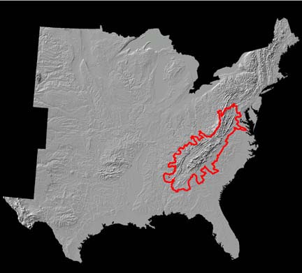
The Southern Appalachian
region encompasses more than 70 million acres in the mountainous portion
of eight states from Alabama to Virginia. The region has been drawn historically
in many ways. We have used a combination of ecoregion divisions and watershed
boundaries to delineate the extent of the region.
Overview:
A Vision for Lasting Protection in the Southern Appalachians
The Southern Appalachian
mountains support one of the most biologically diverse temperate forests
in the world. At least 3,000 species of plants, including some 150 tree
species, are native to the region. Along with a wealth of plants, with
origins both tropical and boreal, our region is a center of diversity and
evolution for salamanders species. The broader southeast region is home
to a vast number of fish, mussels, snails, and crayfish that make it world
renowned for its aquatic diversity. Much of this aquatic diversity occurs
in streams or rivers of the southern Appalachians or depends on waters flowing
out of its mountains.
The Southern Appalachian region also hosts the most consolidated
ownership of public lands in the eastern United States. In the region
at large more than 5.5 million acres are in national forest ownership,
along with another 0.9 million as national park and national recreation
area ownership. Significant amounts of land are also under various
state, federal, and other conservation ownership. Some lands are
permanently protected through wilderness designation or management;
substantial roadless areas and lands with low road density also
remain in the region. These remnants of the natural landscape, coupled
with other lands already managed for conservation, can form the foundation
for the long-term recovery and protection of the region’s natural
wealth.
At a glance, the natural areas of the southern Appalachians appear
as healthy and vast as they are biologically rich and unique. Yet the truth
beneath the forest canopy is that the region’s conservation future
is extremely vulnerable. Today, more than 50 species of plant and animal
are federally listed as endangered or threatened with extinction. Many more
species are in decline and face an uncertain future. Exotic species, habitat
destruction, habitat fragmentation, and air pollution raise the specter of
continuing loss of species and diversity. Key species and species groups,
such as native predators, are entirely missing, with inadequate habitat and
prey for successful recovery at present.
While some natural areas are protected through legislation or strict
management practices, they are generally small and isolated from each
other. In a region that hosts plant and animal diversity of global significance,
these islands of nature are necessary but not sufficient to provide a
connected network of natural areas that will protect ecological processes
and native species into the future. Additional areas should be added to
secure intact ecological units. Intact ecosystems host critical ecological
processes that provide an array of benefits including air and water purification,
nutrient recycling, soil renewal and climatic stability. They are essential
to the continued viability of plants and animals, and by consequence to
our own way of life, whether we live in suburban Atlanta, GA, or rural Damascus,
VA.
In parts of the Southeast, urban expansion ranks among the most aggressive
in the United States. Increasing development is of special concern in
a region where close to 50 percent of the national population already lives
within a day’s drive. The alteration of natural habitats owing to
human encroachment threatens the quality of the air, land and water upon
which all of us depend. The time is ripe for a comprehensive vision for
the protection and restoration of this invaluable refuge.
The Southern Appalachian Forest Coalition (SAFC) advocates a new way
of understanding the region that employs both regional and landscape-scale
analysis and planning. First of all, regional analysis has already played
a key role in protecting the heritage of the region. A landmark analysis
from the turn of the twentieth century (Wilson, 1902) led to initiatives
resulting in a legacy of public lands in the region. Regional analysis at
the close of the twentieth century (SAMAB, 1996) provided an excellent snapshot
of a wide variety of environmental and social conditions almost a century
later. Analysis and planning in our rapidly changing world requires more
than a snapshot. If we are to protect and restore the essential nature of
the region, we require a regional perspective as a fundamental part of all
analysis and planning.
Secondly, landscape analysis, which addresses relatively large areas
irrespective of political or ownership boundaries, is profoundly missing
in most management decisions, plans, and projects. Analysis by site, special
area, ownership, county, or state is the norm. Such analysis and planning,
while essential, is unable to perceive landscape biological needs and
relationships. The landscape perspective relates decisions and plans to
biological habitat for wide-ranging species and breeding populations of
less mobile species, and provides a framework to address connectivity between
areas. Recognizing and planning for landscape conservation areas such as
the ones profiled in this document are a necessary requirement to effectively
provide for long-term biological and ecological health in the region.
Conservation groups throughout the region have devoted years of research
to identify remaining natural areas and the means by which they can be
restored and sustained. SAFC has worked with these groups to bring their
proposals together with additional biological and watershed inventories
to generate a regional overview. A variety of such “special
areas” (see Section VI D.) are the building blocks for larger landscape
conservation areas which, taken together, could function as a regional conservation
network. The landscape and regional perspectives together provide a powerful
framework to determine such issues as how our public lands are managed,
or what are the priorities for public acquisition. The landscape and regional
context can also demonstrate to private landowners the important role their
lands play for conservation and ecological integrity.
Many of these lands have spent most of a century recovering from decades
of abuse, and are ready to assume their role in a regional conservation
network. The people of the region are also receptive to conservation initiatives.
There is tremendous pride and support for natural area protection in the
region. Today, the Southern Appalachian economy relies far more on wealth
generated by healthy natural systems than it does from harvesting timber
and other products on public lands. SAFC’s report Our Green is Our
Gold documents that the economic benefits of tourism and recreation
outweigh those from timber production more than 30 times over.
With this basic foundation of supporting work, SAFC and its constituent
groups envision a biologically diverse region sustained by a connected network
of large natural areas. This vision can only occur if critical areas of
our public lands are permanently protected and supplemented with new public
acquisitions and private lands managed for conservation. As the following
pages demonstrate, the building blocks exist for our region to become a
global model for ecological and economic health flourishing in concert.
SAFC’s conservation strategy identifies those building blocks and
the mortar that can hold them together.
Building Landscape Conservation
Areas from Conservation Elements
The Southern Appalachian region encompasses more than 70 million
acres in the mountainous portion of eight states from Alabama to Virginia.
The region has been drawn historically in many ways. We have used a combination
of ecoregion divisions and watershed boundaries to delineate the extent
of the region. (map to accompany text)
Establishing a network of landscape conservation areas in a developed
region like the Southern Appalachians depends in part on protecting and
restoring critical conservation building blocks within core areas of habitat
and linking these core areas together. The important first step is to ensure
the integrity of the existing and restorable large conservation areas of
the region.
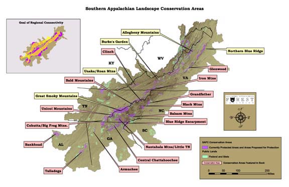
SAFC has concentrated its efforts on identifying conservation building
blocks that ensure the integrity of at least 20 landscape conservation
areas concentrated in portions of the region where national forest ownership
provides the opportunity for protection. Conservation building blocks
include (1) currently protected natural areas, (2) unprotected natural areas,
(3) old-growth areas, (4) biological hot spots, (5) aquatic watersheds,
(6) high-priority areas for public acquisition, (7) conservation easement
areas, and (8) cultural and heritage areas. Management of these components
to achieve their highest conservation potential will help establish and restore
landscape-scale conservation areas.
Inventory of potential building blocks is far from complete. In
fact, many of these landscape conservation areas have not yet been widely
recognized as conservation areas, and therefore they are not managed
with clear knowledge of their landscape or regional importance. It is
time for the essential building blocks within these areas to be identified
and for the larger areas themselves to be acknowledged as priceless and
irreplaceable conservation areas.
At the same time, sufficient work has been done to identify important
landscape areas and to structure the basic outline of a regional conservation
system. We feel that it is important to begin work on the areas that
are already known, even as we continue the search for other critical components
of a regional network. It is clear that the landscape areas already
identified in this document will form the heart of any future regional
conservation network. Without them any future system would lack the integrity
that is needed to ensure the health and continuity of habitats.
The accompanying chart shows the acreage of conservation elements
within national forest lands that SAFC is proposing for dedicated conservation
management within the following national forests: George Washington-Jefferson,
Cherokee, Pisgah, Nantahala, Sumter (Andrew Pickens District), Chattahoochee,
Talladega, and Bankhead. These national forests make up 4.7 million acres
of federal ownership. Within this national forest ownership we have identified
2.8 million acres of wildlands, old growth, biological hot spots, special
watersheds, and cultural areas that we propose for some form of permanent
protection to be added to the existing 382,000 acres of existing wilderness.
These lands are the key elements to maintaining or restoring the biological
and ecological integrity of large landscape conservation areas. Additional
acquisitions, conservation easements, ecological management of remaining
public lands, and addressing man-made barriers would help consolidate these
areas as functioning conservation core areas.
SAFC’s protection efforts have been focused on national forest
protection on eight of the national forests in the region concentrated
in the Blue Ridge and Ridge and Valley portions of the region and including
portions of the Cumberlands. To give context to this work we have
encompassed a larger region defined along ecological and watershed boundaries
and have conducted some landscape analysis for this larger area. Our detailed
proposals do not address the entire regional area in a comprehensive proposal.
Conservation areas do not have distinct boundaries and conservation networks
will not truly succeed unless they connect to other conservation networks.
It is our hope that other conservation initiatives will join our own along
the margins of our region where our view is necessarily incomplete and merely
suggestive.
SAFC Conservation Vision
- Changing How The Region Is Perceived
Establish the benefit and necessity of analyzing and planning
- At the Regional Level
- At the Landscape Level
Regional and Landscape planning make conservation choices at sites
and for special areas clear
SAFC’s Proposal for Conservation Lands in the Southern Appalachians
- Assure conservation
management of critical natural areas,
- Acquisition of important
private lands from willing sellers,
- Participation by willing
private landowners in conservation management through easements and other
long-term commitments,
- Establishment of functioning
conservation areas across the landscape,
- Establish corridors
between conservation areas so that the areas function as a regional network
of conservation areas.
SAFC’s Land Proposal Builds Toward A Vision Of Ecological
Restoration
- Represent all native
ecosystem types and successional stages across their natural range of variation
- Maintain viable populations
of all native species in natural patterns of abundance and distribution
and reintroduce extirpated species
- Biological connectivity
between populations, communities, and ecosystems at different spatial
scales
- Maintain responsiveness
to short-term and long-term environmental change
- Maintain ecological
and evolutionary processes
A Variety of Conservation Efforts Can Be Built Upon SAFC’s
Conservation Vision
- Raise awareness and
appreciation of Southern Appalachian conservation values
- Legislative Protection
- Forest Planning
- Defense of key areas
from management that destroys conservation values
- Acquisition of critical
tracts for public lands
- Promote conservation
easements
- Promote sustainable
development
SAFC Conservation Vision Can Inform Conservation Efforts –
SAFC Does Not Have To Do It All
- SAFC Efforts: Legislative
protection, key area acquisition, national forest planning, agency reform,
national policies
- Local and regional
conservation groups: Efforts in common with SAFC, defense of areas, private
lands management
- National Groups: Agency
reform, national policies,
- Land Trusts: conservation
easements, encouragement of land ethic
Conservation Area Building
Blocks
- Protected Wildlands
- Unprotected Wildlands
- Old Growth Forest
- Biological Hotspots
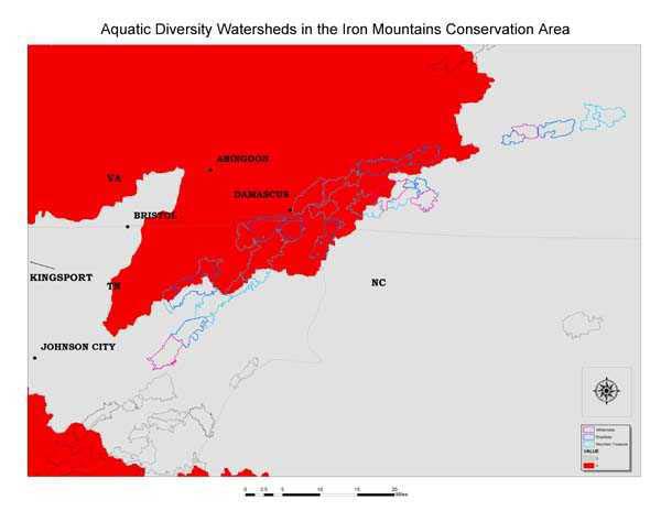
- Aquatic Diversity Area
Watersheds
- High Priority Areas
for Public Acquisition
- Conservation Easements
- Cultural/Heritage Areas
The Regional Conservation Plan is Composed of Landscape Conservation
Areas
Within the regional conservation plan, landscape conservation areas
reveal much of the detailed ownership/management patterns and relationships
Using Biological Values to Evaluate and Prioritize Special Areas
The Regional View:
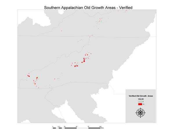
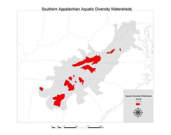
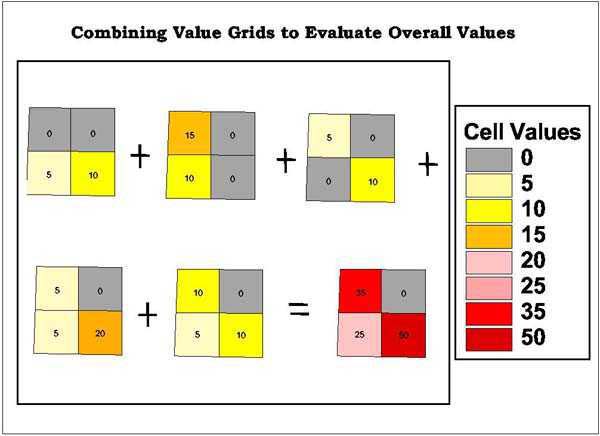
Coverages representing desirable attributes for conservation are converted
to grids with values that represent relative contributions to conservation
priorities.
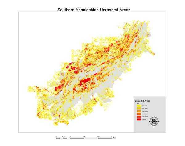
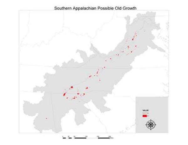

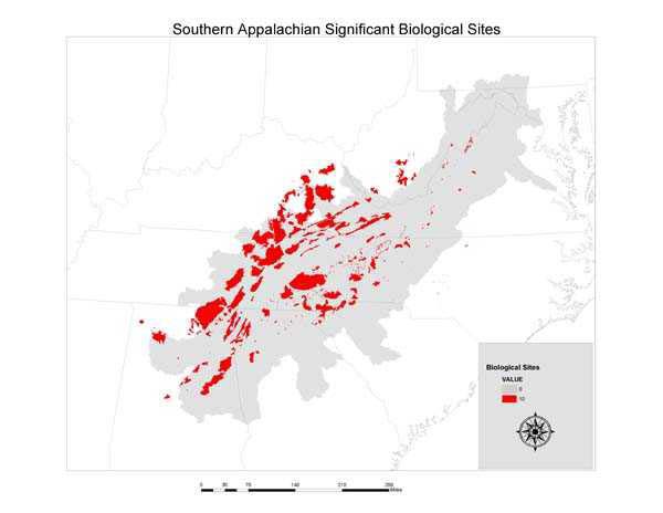
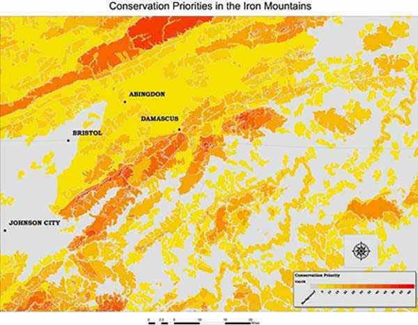
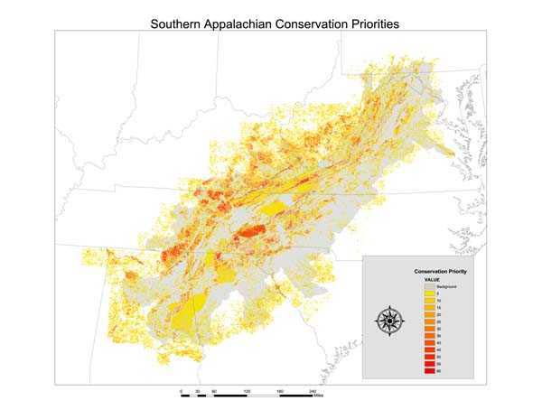
The values for all of
the grids are added to get a resultant "conservation priority" grid.
Using Biological Values to Evaluate and Prioritize Special Areas
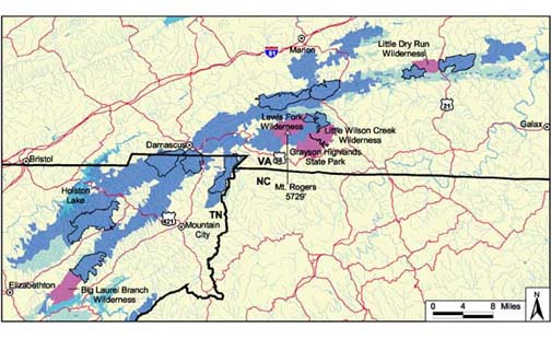
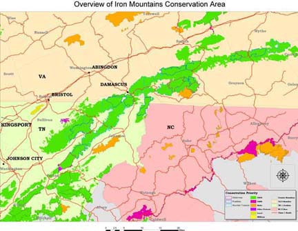
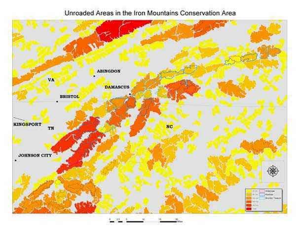
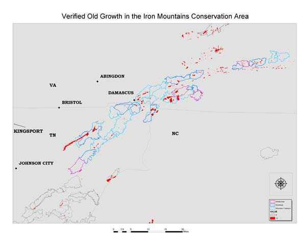
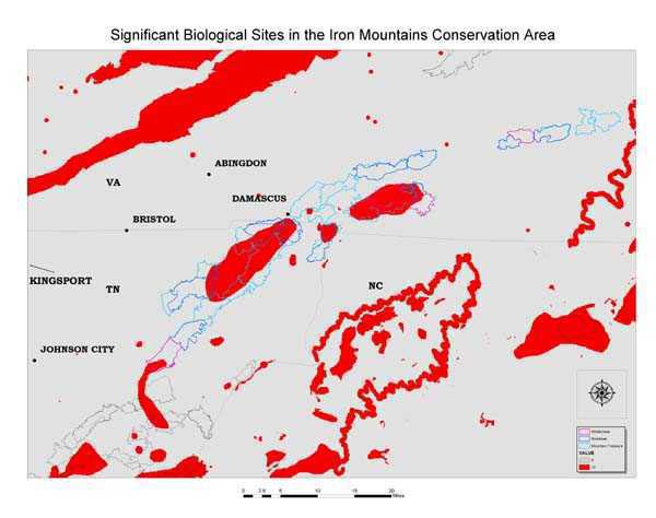
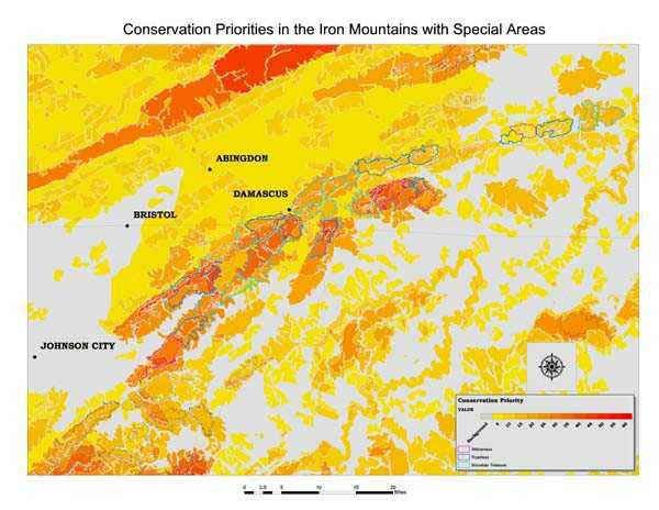
The Landscape View: Iron Mountains Example
Conclusions
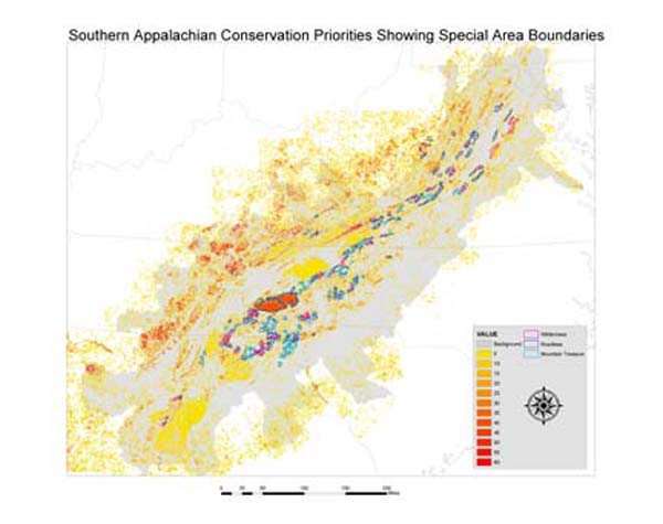
Grid Analysis of conservation values in the Southern Appalachians and
also in Landscape Conservation Areas serves to verify the conservation value
of previously identified "Special Areas" - wilderness, inventoried roadless,
and conservationist identified Mountain Treasure areas. Within these
special areas the grid analysis provides a tool to evaluate the relative
conservation priorities of areas. The analysis also offers a tool to evaluate
other tracts of land for conservation purposes. One of these uses would
be to evaluate areas being considered for public acquisition. Since funds
for acquisition are in limited supply, evaluating the relative conservation
value of prospective tracts could help determine priorities for acquisition
campaigns.
Since conservation values were relative and somewhat subjective, different
values could have been assigned for different conservation attributes.
Some sensitivity analysis has been performed to see what effect changing
values would make in the overall outcome. Although the separation between
lowest and highest values is changed, the overall pattern of significant
conservation areas remains relatively unchanged. The high priority
conservation areas remain relatively constant under a variety of assigned
values.
Author Information
Hugh Irwin
Conservation Planner
Southern Appalachian Forest Coalition
46 Haywood Street
Suite 323
Asheville, NC 28801
email:hugh@safc.org
(828) 252-9223
FAX (828) 252-9074

