Kyle N. Campbell and Shawn M. Landry
A key component of improving water resource management in Florida is providing local stakeholders with user-friendly access to quality assured data. Unfortunately, the data concerning water resources are often dispersed between multiple agencies, in proprietary databases, incompatible formats, and almost never easily accessible or understandable by citizens and stakeholders. The net result is often a duplication of sampling effort among agencies and lack of awareness and support from the local citizenry for restoration and management efforts. To solve this problem, the University of South Florida, in conjunction with many government agencies, have developed an online Watershed Atlas that serves timely data from many sources in a citizen-friendly application. Functionally, the application allows users to dynamically map watersheds and water resources and browse data by water resource or watershed in multiple categories such as water quality, hydrology, ecology, and management. Advanced tools allow scientists to graph and query any parameter from more than 10,000 water quality records and 206,000 hydrology records. Techniques used to build this application include stakeholder involvement and protocol development, GIS development using SDE, database design in Microsoft SQL, and web application development using server side technology such as an ActiveX ArcIMS mapping application and Active Server Page technology. Preliminary results of this work indicate the Atlas is extremely effective and enhances communication between agencies and citizens, fosters use of quality assured data in decision-making, and increases interest in volunteer monitoring programs.
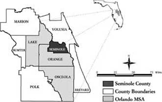
Seminole County, which is located in the Orlando Metropolitan Area, and its seven municipalities, are responsible for the management of 16 watersheds that directly influence many of the regions most important public water resources including the St. Johns River, and several officially designated Outstanding Florida Waters including: the Wekiva River, Little Wekiva River, and Big Econlockhatcheee River. Unfortunately, the data concerning these resources are collected by widely disparate agencies at varying levels of federal, state, and local government. The result for an environmental professional working on these resources is often a costly data search and time intensive conversion process. For citizens and other less savvy stakeholders, access to quality-assured data along with interpretative educational materials are simply not available. To fulfill the need to establish a system that would bring together scientific data, educational information, and geographic information systems (GIS) maps of the county in an easily accessible and understandable format, Seminole County funded the University of South Florida to create the Seminole County Watershed Atlas. To accomplish the goals of the program, the Atlas uses key technology such as Esri's Spatial Database Engine (SDE), Microsoft SQL Server, ArcIMS, and Active Server Pages (ASP). The Watershed Atlas application is comprised of four primary components: an ArcIMS interface, water resource data pages, advanced graphing tools, and a document library.
The ArcIMS interface is shown in Figure 1 and allows users to view multiple themes such as hydrography, wetlands, political boundaries, watershed boundaries, and aerial photography. The user can navigate to a water resource of interest through an address search or by browsing the map. Once a resource is in view, the user can select the resource with a select tool or choose to bring up a hyperlinked table of the water resources in the view. Either choice directs the user to a series of data pages driven by ASP.
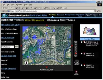
Figure 1. ArcIMS Interface on the Watershed Atlas.
The water resource data pages summarize data by topic and display key indexes and parameters for determining the current conditions of a watershed, lake, river or stream. The data are organized by sections: general information, water quality, hydrology, ecology, management, and photographs. Figure 2 illustrates a typical general information view for a lake. The data are published in timely or near real-time intervals on the Atlas using automated protocols.
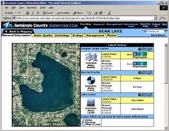
Figure 2. General Information view of a specific waterbody on the Watershed Atlas.
Advanced Tools allow users to query, graph, and download from any of the nearly twenty data sets in the Atlas. Figure 3 illustrates a sample screen shot of this functionality from a soon-to-be-released Atlas.
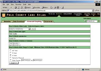
Figure 3. Example Advanced Graphing tools from a soon-to-be-released Atlas.
The Atlas was developed in four major phases. The overall system architecture is shown in Figure 4. Data providers and stakeholders were responsible for providing both geographic and parametric datasets and documents. These data were then loaded into a newly designed Microsoft SQL Server database running SDE and known as the W-RAD (Water Resources Atlas Database). The web application using Internet Map Serving (IMS) technology and Active Server Page technology (ASP) would serve the quality-assured data to the citizens through a user-friendly interface.
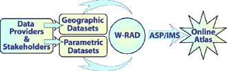
Figure 4. Illustration of overall system architecture.
The first phase of Atlas development was research intensive and required significant stakeholder involvement. To facilitate intergovernmental coordination, an advisory committee was formed. The advisory committee helped to identify data providers, provide input on data presentation, and ensured cooperation with agencies they represented. A metadatabase was developed to catalog all available and relevant spatial and tabular data. Once the data sets were prioritized, protocols and procedures were developed for data transfer between the host agencies and the University of South Florida.
Spatial data development required the creation of a comprehensive 1:24,000 scale hydrographic GIS data layer. The layer was created in ArcInfo coverage format from multiple sources: the USGS Digital Line Graph, Seminole County hydrography, aerial photography, and St. Johns River Water Management District data. The subsequent coverage was loaded into SDE and contained attribute fields for name, alternative name, upstream segment, downstream segment, and a unique waterbody identifier (waterbody ID). The waterbody ID served as the unique identifier for each water resource in both the SDE dataset and the corresponding parametric datasets. The resulting SDE database contains over 2,700 waterbodies within Seminole County, of which only 232 are named waterbodies accessible on the Atlas. Once this layer was complete, a sample site coverage was built in ArcInfo to contain each sample location from each source data provider. Oftentimes, coordinates for these data were provided in a lat/long coordinate system and when these data were overlaid on the hydrography base map they were not accurate. A quality control procedure was developed to assign these wayward sample sites to the appropriate water resource.
The Water Resource Atlas Database (W-RAD) was designed as a data warehouse for sample data originating from many separate data providers and sampling programs. As data providers used various data management systems, the W-RAD was designed with Microsoft SQL Server Data Transformation Services data load tools customized for each source dataset. Each of these data load tools was programmed to automatically import source data, appropriately transform parameters to common units (e.g. milligrams per liter), perform quality control to remove inaccacurate records, and store each dataset in a separate data table specific to the source. Equally important, the data load tools assigned the correct waterbody identifier to each record, based upon the previously mentioned sample site GIS layer.
Separate data tables were created to store data from multiple data sources into a single table based upon data type, such as water quality, hydrologic, and ecological data. Each record in the combined table is identified according to source, waterbody ID, and sample site id. Data queries from individual web pages access the data stored in these combined tables either directly or indirectly using data views. Water quality indexes, such as trophic state index and water quality index, are also calculated from these combined tables.
In addition to parametric datasets stored in the W-RAD, a document catalog was developed to store all educational information according to subject, watershed, and waterbody were appropriate. All educational, management, and research oriented documents and resources (e.g. outside links) are stored within the database to eliminate the need to maintain static html-based web pages.
The spatial data were loaded into ArcIMS and several layers were loaded into each map service. Symbology and labeling were created in each service and the appropriate scale dependencies were configured. Rather than using the HTML viewer or the Java version, the ArcIMS application for the Atlas was developed in ASP using the customized ActiveX connector architecture. The decision to use the ActiveX architecture of ArcIMS was based on the following factors: the rest of the application used Active Server Page technology and NT servers, a thin-client solution was desirable for the general public, and the widest possible browser compatibility was desired. The only disadvantage of using a fully customized application is the programming time and expertise required for application updates. Optimal hardware required to support the application was based on Esri staff recommendations as well as recommendations from existing ArcIMS users, and our estimates of site usage. Since other counties were interested in implementing the Atlas, hardware requirements were based on serving multiple applications. Table 1 illustrates the current server configuration. To optimize performance of the application, server functionality has been separated between map, web, and SQL servers. The current response time for an ArcIMS request is usually less than 2 seconds. As additional Atlas applications will undoubtedly decrease ArcIMS response time, a future optimal configuration will require multiple servers designed to separate the ArcIMS application server, monitor, and web server currently installed on one server.
Table 1. Existing Watershed Atlas Server Configuration.
| Atlas Component | Programming Language | Server Configuration |
|---|---|---|
| Web Pages | Active Server Pages | Microsoft Windows 2000 Advanced Server installed running Internet Information Server 5 on two Dell PowerEdge 2350 servers |
| ArcIMS Mapping | Active Server Pages using the ActiveX connector | Esri ArcIMS 3 and Microsoft Windows 2000 Advanced server running Internet Information Server 5 installed on one Dell PowerEdge 6350 |
| W-RAD database and SDE | Microsoft SQL Server | Microsoft SQL Server 7.0 and Windows NT Server installed on a Dell PowerEdge 6300 |
The Watershed Atlas application is providing unprecedented access to water resources data and educational materials for the local citizenry and environmental professionals. Two months after launch, the average number of user sessions per day was slightly over 100, a small but respectable number since the site had not yet been publicized. However, County staff have already noticed that the interest in local volunteer programs has increased. Statewide in Florida, the Watershed Atlas has fostered interest in the program and seven additional counties in central Florida are under development. In addition, a collaboration with the Florida Department of Environmental Protection is underway to make the application compatible with EPA's STORET database, using the Watershed Atlas as a front-end to provide data access to STORET. A key to success in applications such as the Atlas that serve data from multiple resources is early stakeholder involvement, the development of appropriate data transfer and quality assurance/quality control procedures. The technology is often the least complicated component of the overall application development. Allowing for sufficient time to process source data is also a necessity, as oftentimes, spatial data are lacking in appropriate metadata documentation and may require additional time for quality control.
Esri SDE is a good choice for serving large datasets such as hydrographic base maps, but may not improve performance of the ArcIMS application with smaller datasets. Data warehouse solutions such as the W-RAD should be designed with an emphasis placed on data access rather than data storage. Because water resource data is only useful when each sample site is tied to a geographic location, careful integration between GIS and parametric database design should be paramount. Fully customized ArcIMS solutions can greatly improve performance for the client but do require additional time and expertise. However, once they are developed, minor customization allows the application to be used for other online mapping applications. Allowing for scalability with the hardware installation and separating functionality across servers improves performance and simplifies installation conflicts. Finally, tracking statistics and monitoring performance of an online mapping application is essential. Many applications are launched with dismal response times, and as a result usability declines.
Jim Griffin, Marty Kelly, and Southwest Florida Water Management District
Mark Flomerfelt, Kim Ornberg, and all the folks at Seminole County Public Works
Carlos Fernandes, Hillsborough County Public Works
Kyle N. Campbell: Co-Author and Presenter
Director
campbell@arch.usf.edu
Shawn M. Landry: Co-Author
Senior Scientist
landry@arch.usf.edu
Florida Center for Community Design and Research
University of South Florida
3702 Spectrum Boulevard, Suite 180
Tampa, Florida 33612
Phone: (813) 974-4042
Fax: (813) 974-6023
Website: www.fccdr.usf.edu