ABSTRACT
The Florida Division of Forestry has recently embarked on the development of a statewide fire risk assessment system using the latest in remote sensing data and GIS technologies. The core component of the system is a GIS based Fire Risk Assessment application (FRAS) using ArcInfo integrated with the FLAMMAP fire risk model. This system will assist fire managers with the mitigation of the harmful effects of wildfire and will function as a valuable planning tool for local fuel reduction efforts.
GIS layers of wildland fire susceptibility, population density, land value, and fire response accessibility will be weighted, ranked, and combined to develop estimates of "Levels of Concern". The FRAS application will be flexible, such that the input values can be easily adjusted and the model re-run to produce new estimates of risk as levels of concern change. This paper will review achievements and issues associated with integrating remote sensing, GIS and external models for fire risk assessment. Keywords: fuels mapping, wildfire risk assessment, remote sensing, GIS, Florida
For as long as there has been vegetation growing in Florida's wildlands there have been periodic wildfires. As a result most of the indigenous species (plant and animal) have evolved with fire over many thousands of years. Wildfire is a natural phenomenon initially finding its origin in lightning but also with anthropogenic roots. Humans have spread fire to virtually every ecosystem on Earth. In addition to using and controlling fire, humans are the primary ignition source vectors for the propagation of fire, and modifiers of fuel sources (Pyne, 1992).
The role of fire in the wildlands of Florida has sparked a heated controversy that has been going on since the later part of the 19th century. The U.S. Forest Service, in an attempt to determine why Southern land managers continued to use fire as a management tool, contracted with a psychologist to research this behavior. Dr. Shea published an article in American Forests 1940, titled "Our Pappies Burned the Woods," where he was quoted:
"With the closing in of the agrarian environment, it [burning the woods] has become predominantly a recreational and emotional impulse... the sight and sound and odor of burning woods provide excitement for a people who dwell in an environment of low stimulation and who naturally crave excitement.... Their explanations that woods fires kill off snakes, boll weevil and serve other economic ends are something more than mere ignorance. They are the defensive beliefs of a disadvantaged culture group."
Herbert Stoddard countered this with "The conditions under which developed the magnificent virgin stands of southeastern pines, having included frequent burning, surely carefully controlled fire for the benefit of animal life adjusted along with the forests to periodical, though uncontrolled, burning through the ages has the merit of following an established and successful procedure. In our opinion, to exclude fire permanently from the park-like pinelands of the Southeast is to jeopardize both the flora and fauna and to contribute to their replacement by other and inferior types of animal life and vegetation. How many who are advocating total fire exclusion in this region have seriously considered the consequences of disturbing this age-old adjustment?"(Tall Timbers Research Station 1961, p.197) Although the use of prescribed fire by land managers is generally accepted by forestry professionals today, the general public is still frequently confused and even angered by its use.
First among the concerns about wildland fires are the rapidly growing population pressures seen in many rural areas of the country, these same rural population pressures are evident in Florida. This paper defines wildland fires as those fires, which burn vegetative, cover: grass, grain, brush, timber, or slash (Garner, 1989). In the past, rural typified an agricultural community, today, rural is also characterized as residential. During the early settlement of the country, rural residents reduced forest fuels and fire proofed their properties as part of rural fire protection practices. As the populations moved to urbanized areas, rural fire protection practices became urban fire practices. Today, new rural communities are becoming increasingly popular, however, their behavior patterns have reversed, forest fuel loads are often left undisturbed or even increased because of aesthetic or scenic reasons. In areas of dense rural settlement, homes can actually add to the fuel load available to a wildfire, increasing the size and magnitude of the fire. In short, early settlers relied on fire use to reduce fire risk, the new rural settlers rely on urban fire organizations such as the volunteer fire departments for fire protection.
Today, many areas only experience infrequent fires that result from escaped human caused fires, intentionally set incendiary fires, or from lightning. These fires frequently occur when conditions are so severe that control measures may be ineffective in stopping the fire. As a result, major economic losses are experienced by land managers and homeowners. In addition to this, there is the very real threat to the lives of both the residents and the fire fighters in the areas threatened, as well as the firefighters attempting to put out fires in areas where the fuels have been left to accumulate over an extended period of time.
At this time, it is the intent of the Florida Division of Forestry to conduct a "Risk Assessment Analysis" that will allow agencies and organizations at both the state and local levels to obtain a clear picture of the challenges to wildland fire management in Florida today. This will put the appropriate tools in the hands of land managers, local planners, county administrators, as well as emergency personnel to prioritize their work in mitigating future wildfire hazards in Florida. This paper will outline the scope and objectives of the Florida Fire Risk Assessment project and the methodology employed by Pacific Meridian.
Florida's fire managers face an ever increasing and complex problem due to; the accumulation of vegetative materials, continued residential growth into wildland fire-prone areas, and growing fire fighting jeopardy and costs. The state of Florida has been progressive with respect to wildland fire management for many years. Advanced spatial technologies are being brought to bear on the issue and will provide a valuable decision-making tool. Florida needs a process to weigh fire hazards and risks against the values to be protected in order to more accurately deal with the threat from wildfire, as well as manage the largest open burning program in the country. This process will provide managers with a strategic view of the state to improve public safety and protect them from property losses like those experienced over the past few decades.
Increasing growth of rural populations, increasing urban sprawl, increasing usage of wildlands for recreation, and increasing forest fuel loads all pose an immediate and direct threat to the contact zone between wildlands and people. This contact zone is termed as the Wildland/Urban Interface. The Wildland/Urban Interface is defined as the line, area, or zone where structures and other human developments meet or intermingle with undeveloped wildland or vegetative fuels (United States Fire Administration, 1990; U.S.D.O.I., 1995). The Wildland/Urban Interface has become the site of a potential major fire problem that will continue to escalate as the nation moves into the 21st century (Davis, 1990). When people and wildlands come into contact conflict arises, either directly form the threat of wildfire or from an inadequate emergency service infrastructure necessary to protect the Interface. Florida has several distinct types of urban interface characteristics due to its unique historical development. The ' block' subdivision, for example, has caused a tremendous challenge to mitigation and fuel reduction efforts.
The Florida Division of Forestry supports a wildland fire risk analysis because it would benefit the state by promoting efficient, safe management of fire by assisting both private and public organizations to:
* Rapidly identify areas that may require additional tactical planning,
* Allow agencies to work together to better define priorities and improve emergency response,
* Develop refined analysis of complex landscape and fire situations using GIS,
* Increase communication with local residents to address community priorities and needs,
* Plan for resource needs.
* Identify resource allocation based on potentially severe fire problems.
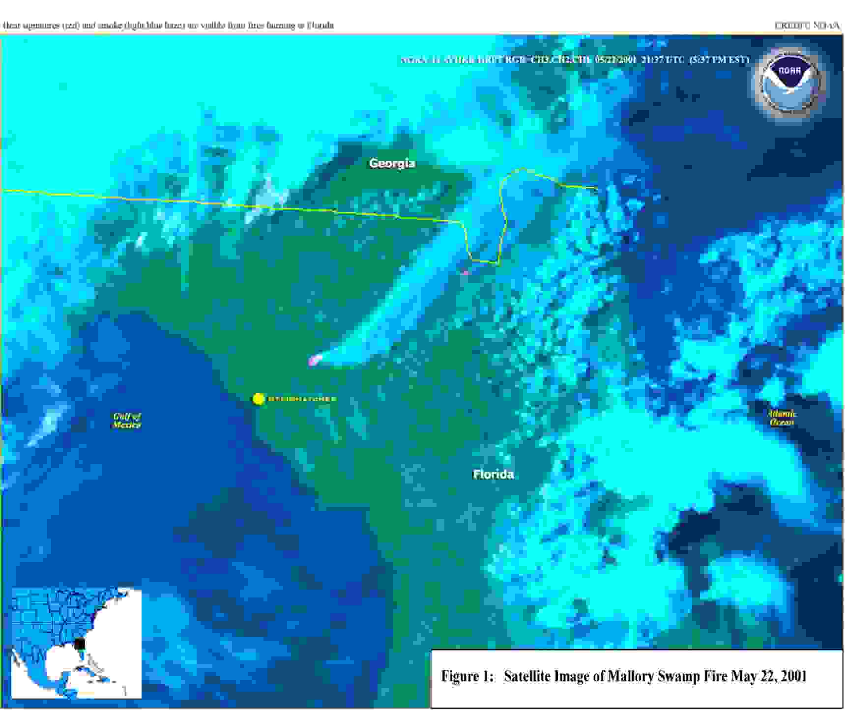
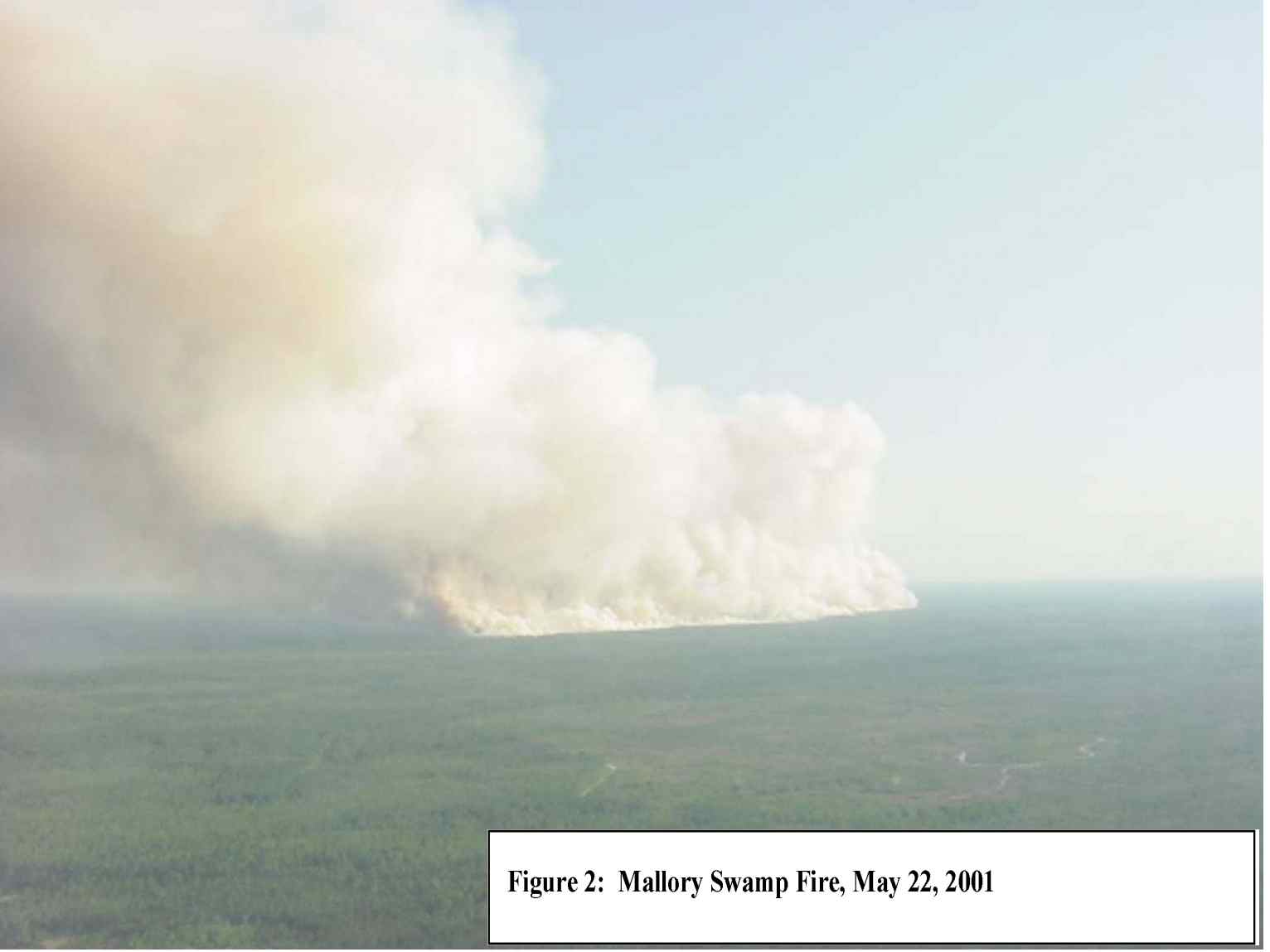
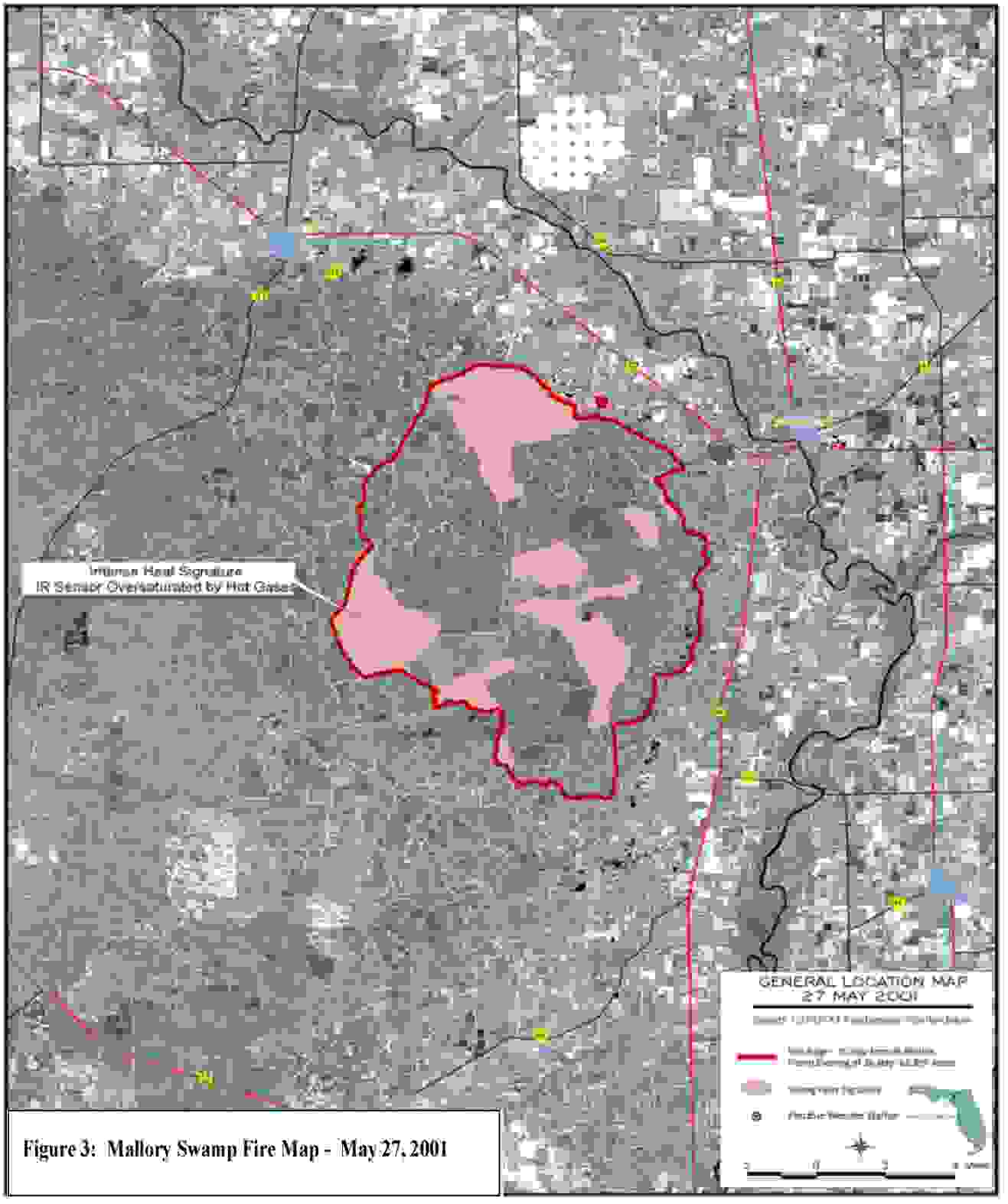
Florida possess a unique set of characteristics that make much of the state highly susceptible to wildfire: First, the state is blessed with an abundance of wildlands. Unfortunately, the state has also experienced an explosion of new residents into these wildlands, creating an urban/wildland interface problem in a large portion of the state. Second, Florida's weather is conducive to starting and spreading numerous and sometimes large wildfires. Florida's rate of lighting strikes is unequaled in the nation. Lightning, coupled with extended periods of drought, set the stage for catastrophic fire episodes. Human-caused fires are ever increasing as the population rises, and account for a major portion of Florida's wildland fires. Table 1 shows the average percentages of fires by cause for the past 10 years in Florida. Finally, Florida's wildland vegetation evolved with fire. The vegetation is adapted to periodic fire occurence. Fine fuels, which are easily ignited and spread fire rapidly, are abundant throughout Florida. The lack of managed fire in much of the wildlands has promoted an accumulation of these fuels that will burn with such intensity as to hamper suppression efforts.
Table 1: Average Percentage of the Number of Fires In Florida 1990-1999 by Cause Lightning Camp Fire Smoking Debris Arson Equipment Railroad Children Unknown Misc. 18.9 2.3 1.9 18.5 24.1 5.0 0.9 5.8 14.0 8.6
To reduce the loss of life and property due to wildfire, communities and fire management organizations need to actively manage fire risk. However, managing fire risk is extremely difficult because fuel hazard constantly changes across the landscape and through time, and fire behavior is extremely sensitive to changes in land development, fuel hazard, weather conditions, and topography. In addition, many social, technical and institutional barriers exist to proactive fire risk management and planning. Some of the most worrisome problems are summarized below.
1. Problem: Currently, fire suppression and mitigation activities are highly dependent upon the knowledge and intuition fire management personnel. While local knowledge is irreplaceable, it can also be limited because of the human mind's inability to simultaneously conceive of all possible fuel conditions and fire paths.
Need: Fire suppression personnel need accurate fire risk assessment tools to simulate future fire events, and to test the sensitivity of the simulations to changes in variables such as fuel, weather, and land use.
2. Problem: The dramatic nature of wildfires focuses public attention on fire suppression and not on mitigation. For example, immediately following the Oakland hills fire in 1993, residents called for fuel management and wider streets (to improve emergency response). However, within one year of the fire, efforts to widen streets were abandoned because of property owner opposition. Fire risk awareness tends to be highly correlated with elapsed time following a catastrophic fire.
Need: Fire management agencies need educational tools, including fire risk visualization, that make the threat of fire immediately apparent to property owners.
3. Problem: Funding for fire management is heavily concentrated in fire suppression instead of fire mitigation. This concentration is partially a result of the catastrophic nature of fire and partly a necessity - directly attacking a burning fire in a specific location is usually a necessity, while broadly applied mitigation measures seem discretionary. However, most fire management professionals agree that funding spent on fire mitigation and prevention has the potential to greatly decrease losses from wildfires.
Need: Fire management agencies need efficient fire planning tools, which allow them to assess and prioritize fire risk mitigation before a fire occurs.
Discussions concerning wildfire management usually center on estimates of fire hazard and risk. Fire hazard describes the fuel at a particular location as determined by the fuel type, loading, condition, ease of ignition, and difficulty of suppression. Fire risk on the other hand, is defined as: the chance of a fire starting as determined by the presence or activity of a causative agent.
Numerous models for assessing fire risk have been developed throughout the world (Chuvieco, 1999; Schoning, et al., 1997). While the earliest models were non-spatial, recent advances in GIS have allowed for the development of spatial fire risk models. Even the simplest fire risk assessments include variables that account for fuel, topography, and weather. More sophisticated models add variables for assets at risk, housing density, and impediments to fire suppression such as the width, curviness and steepness of roads. Ultimately, the risk assessment undertaken in Florida will take into account all of these variables.
The goal of the project is to develop a Fire Risk Assessment System (FRAS) that: * Identifies and defines the individual elements that compose wildland fire risk and hazard in the State of Florida. * Maps fuels statewide * Models and maps "Levels of Concern" where cooperative efforts between the State, and public and private landowners are needed to focus fuel reduction work. * Allows for analysis of the sensitivity of the location of "Levels of Concern" to changes in model input variables. * Facilitates updating of the model to account for changes in fuels and land use.
The Fire Risk Assessment System (FRAS) will combine several landscape characteristics to create a map of "Levels of Concern" for the State of Florida. The landscape characteristics will include:
* Wildland Fire Susceptibility,
* Fire effects,
* Population Density, and
* Measures of ability to respond to fire occurrences
How the characteristics are combined and the relative weight of each characteristic will be determined through interaction with State of Florida personnel. The following describes the methodology that will be used to develop the above landscape characteristics.
The Wildland Fire Susceptibly Index will be a GIS coverage that combines the potential for fire occurrence with a model of fire behavior to spatially represent wildland fire susceptibility for the State of Florida. The methods used to create the index have been developed in conjunction with Don Carlton, Pacific Meridian's fire modeling consultant.
The Potential for Fire Occurrence (PFO) is calculated using an estimate of the probability of each acre or cell in the GIS database igniting. To do this, the state of Florida will be stratified into areas with uniform fire occurrence rates called Fire Occurrence Areas (FOA). Fire occurrence information, for both federal and state lands, has been collected and will be combined to create a fire occurrence database for the entire State of Florida. The database will include at a minimum, fire location, fire size, and fire cause and will be used to develop the FOAs. The time period for the fire occurrence information will be determined through discussion with the State of Florida (most likely a period of 20 years). Once the fire occurrence database has been checked for accuracy an ignition density value will be assigned to each cell. The cells will be stratified by assigning breaks in the density values (either by percentiles or equidistant breaks) to create discrete FOAs with similar ignition density values. This ordination is done to group cells into a defined number of areas. The final step will be to calculate the probability of an acre igniting for each cell in the FOA. The probability is calculated by dividing the actual number of ignitions in the FOA by the time frame for the ignition data, with the output expressed in fires per 1,000 acres per year.
The FlamMap program will used be to develop a layer of fire behavior for the State of Florida. FlamMap is a computer program that generates fire behavior data for a given set of weather and/or fuel moisture data inputs. The model outputs are based on Dr. Mark Finney's FARSITE (and the Pacific Meridian/Finney FIRE!) fire behavior model. FlamMap outputs are GIS coverages of flamelength, fireline intensity, spread rates, etc. The inputs required to run FlamMap include, surface fuels, upper canopy crown closure, slope, aspect, elevation, and potential weather.
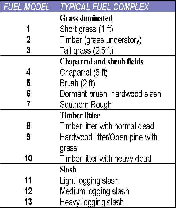
The surface fuels layer will be developed through the interpretation of Landsat Thematic Mapper (TM) satellite imagery. Fuels will be mapped to the 13 Fire Behavior Prediction System (FBPS) fuel models described originally by Albini and further described by Anderson. There are a total of 13 fuel models that fall within 4 basic groups: grass, chaparral and shrub, timber, and slash. The table to the left identifies the fuel models for each group. The crown closure layer will also be developed from the Landsat TM imagery. Slope, aspect and elevation will be derived from Digital Elevation Models (DEM's) and the potential weather will be gathered from the National Weather Service stations with the cooperation of the State of Florida.
The fire behavior modeling process will begin with the development of Weather Influence Zones for the State. The Weather Influence Zones will be generated using historical weather data for the State of Florida from the National Weather Service and the State. This weather data will be used to develop percentile weather for each Weather Influence Zone. Percentile weather will be developed for four categories including low, moderate, high and extreme for input into FlamMap. The proportion of fires that occur by percentile weather category will be determined and will be an input to produce a fire behavior layer using FlamMap. The FlamMap model will calculate fire behavior for every cell in a raster representation of the landscape described by the input layers. Output values will include flame length, heat per unit area, fireline intensity, and rate of spread. The output values of each cell represent how the present fuels will burn under assumed landscape, weather, and environmental conditions.
Outputs from the FlamMap model will be combined with the Potential Fire Occurrence layer describe above to develop a GIS coverage of Wildfire Susceptibility for the State of Florida. The wildland fire susceptibility analysis integrates the probability of an acre igniting and the wildland fire behavior in terms of an expected fire size. The process combines the data from the FOAs with fire behavior data developed by FlamMap. This analysis calculates a Wildland Fire Susceptibility Index (WFSI) for each 30 X 30 meter cell in the study area. The analysis also includes a factor that will limit the size of a fire, because of containment by suppression resources and/or the presence of non-burnable surfaces, such as water or rock.
The formula used to calculate the WFSI is:
WFSI = (Expected acres burned in the FOA) / (Total Burnable Acres in the FOA)
where, "Expected acres burned in the FOA" =
Final Fire Size (FFS) * Number of Fires per Year in FOA
The "Total Burnable Acres in the FOA" value is determined simply by subtracting the non-burnable acres in the FOA from the total acres in the FOA. To obtain a value for "Expected acres burned in the FOA" a rate of spread is calculated for each percentile weather category for each cell in the FOA using FlamMap. A fire size is calculated for each rate of spread using a formula for either contained fires or escaped fires or by using a maximum fire size. The result is fire size for each rate of spread for the cell. The final fire size is then calculated as a weighted average of the four fire sizes. The final fire size is multiplied by the number of fires per year in the FOA to obtain a value for "Expected Fire Size". This "Expected Fire Size" is divided by the "Total Burnable Acres in the FOA" to obtain the index value for the cell.
The fire effects layer will identify features that may be impacted by a wildfire. This layer will be derived from features including cultural resource sites, utility corridors (gas pipelines, transmission lines), hazardous waste sites (above ground storage tanks), threatened and endangered species habitat, urban interface, expensive operations (muck/peat bogs, swamps), plantations, and sensitive areas not identified in the urban interface. A combination of these input layers will provide the State of Florida with the best representation of potential wildfire effects.
The Population Density layer will be derived from Census Bureau data. This layer will be derived from population density as well as housing type and housing density.
The fire response accessibility layer will include features that impede or delay accessibility to a wildfire. This index will be derived from inputs of dead-end roads, drainage ditches, critical roads, areas where accessibility is delayed based on distance from roads and road density, crew locations, personnel number and equipment at each location, and local fire department locations. As with the fire effects layer, using a combination of input layers will provide the State of Florida with the best representation of fire response/accessibility.
The focus of the Risk Assessment is the development of the Fire Risk Assessment Model to estimate "Levels of Concern". The input index layers of Wildland Fire Susceptibility, Fire effects, Population Density, and Fire Response Access will be combined and ranked to develop Level of Concern estimates. Each layer will be ranked for their relative importance to fire planning and management, weighted relative to each other, and scored to produce a derived "Level of Concern" layer (Figure 4). Ranking and weighting will be flexible, so those values can be adjusted and the model easily re-run. This will allow for efficient tuning of the model and allow for updates to the input layers.
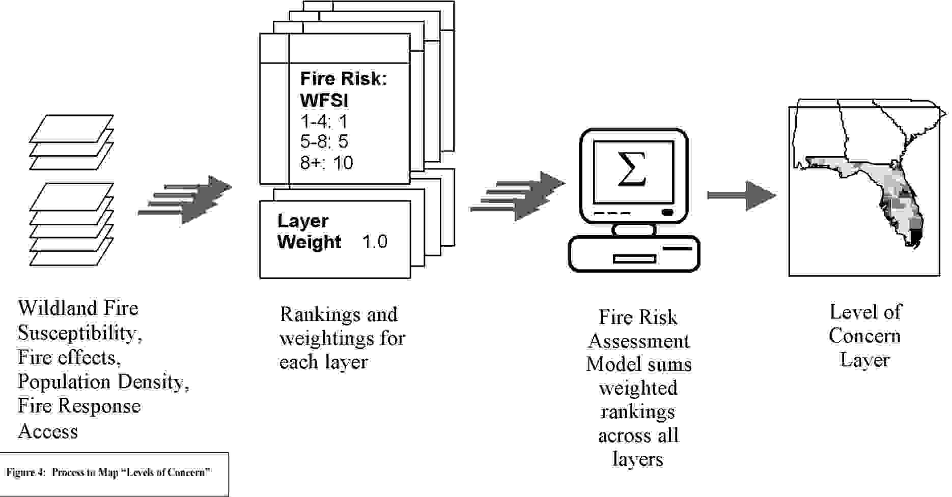
The final step of the Risk Assessment project is to develop a software application to implement the fire risk assessment model. The software will be designed such that the State of Florida can update the model inputs (fuels and canopy closure), modify the rankings and weightings of in the individual input indices, and generate new "Levels of Concerns" maps based on those updates. The software will be designed with an interface that is intuitive and user friendly. This will allow state personnel at all levels to access, update, and derive new information.
Along with the Fire Risk Assessment System the State of Florida will have a substantial statewide GIS database (including mutli-temporal satellite imagery) available for other fire management and planning activities as well as additional natural resource applications.
The advancement of geospatial technologies and capabilities, including the use of GIS data and satellite imagery, will allow managers to make decisions based on the most current information available. The development of the Florida's Fire Risk Assessment System will play a significant role in the way in which fire managers approach wildfire suppression, mitigation planning and public outreach. This valuable tool will provide the State of Florida a consistent statewide approach that will be critical for decision-making in the coming years as the socio-environmental dynamics of Florida undergo increasing pressure from competing economic and development forces.