This paper presents the use of GIS to integrate and display human air pollution exposure data in the Southern California Children’s Health Study (CHS). The CHS is a 12-year prospective epidemiological study designed to improve the understanding of the potential chronic health effects of ambient air pollutants, such as ozone, particulate matter, nitrogen dioxide, and acids. Over the course of the study, over 5000 students are followed longitudinally from ages 10 to 18 to assess respiratory symptoms and pulmonary function by a research team from the University of Southern California’s Keck School of Medicine. The students are residents of 12 communities in Central and Southern California that have unique ambient air pollution profiles. Extensive analyses are conducted of associations between the students’ health outcomes and measured ambient air pollution levels, modeled human air pollution exposure, and other surrogates for exposure such as traffic density. Evaluation of the children’s exposure to pollutants emitted by mobile sources is a particularly important component of the study and one for which GIS is essential. This paper presents a discussion of how GIS is being used for this project and the development of a geodatabase, which integrates the locations of children’s residences and schools with modeled and measured pollutant exposure data.
GIS is used to integrate and display human air pollution exposure data in the Southern California Children’s Health Study (CHS). The CHS is a 12-year prospective epidemiological investigation of the chronic health effects of ambient air pollutants, such as ozone, particulate matter (PM), nitrogen dioxide (NO2), and acids. Over the course of the study, approximately 5000 students are followed longitudinally from ages 10 to 18 to assess respiratory symptoms and pulmonary function by a research team from the University of Southern California’s Keck School of Medicine. The students are residents of 12 communities in Central and Southern California that have unique ambient air pollution profiles. Daily measurements of the relevant air pollutants are made in each of the 12 communities. Extensive analyses are conducted of associations between the student’s health outcomes and both measured ambient air pollution levels and modeled human air pollution exposure.
Many important findings in the CHS come from between-community comparisons (Peters et al., 1999; McConnell et al., 1999; Gauderman et al., 2000). Nevertheless, there are certain health outcomes where within-community variations are comparable to between-community variations after adjusting for common confounding parameters. This raises the question of whether the within-community variations in health outcomes are associated with neighborhood-scale variations in exposure. Obtaining neighborhood-scale measurements of air pollutants for the CHS population would be very expensive given the large number of participants and the complexity of the air pollution monitoring equipment. The next best approach for estimating the neighborhood-scale exposures is air quality dispersion modeling of the principal sources. Motor vehicle emissions are believed to be one of the chief contributors to within-community variations in ambient pollution levels. Regional emission inventories for Southern California suggest that more than 90 percent of carbon monoxide (CO) and over half of nitric oxide (NOx) and particulate matter (PM10) emissions are from mobile sources. Furthermore, several other studies have found relationships between exposure to mobile sources of air pollution and the occurrence of allergy and asthma and lowered levels of lung function (Brunekreef et al., 1997; van Vliet et al., 1997; Studnicka et al., 1997; Wyler et al., 2000). Hence, a sub-study was conducted to estimate ambient concentrations contributed by mobile source emissions in each the of the 12 CHS communities.
The sub-study makes extensive use of GIS technology. ArcInfo is being used to generate and quality assure input data for the traffic exposure model. A geodatabase has been created to archive and display the results of the traffic exposure modeling. GIS is also used to characterize the extent of clustering of residences around schools and the dispersion of participants after leaving the study. This is an ongoing project and the use of GIS evolves continually as new technologies and analysis tools become available.
In order to identify associations between key pollutants and traffic and to characterize exposure differences for children living in the 12 study communities, several pieces of geographic information are required. The first are the residence locations of the children participating in the study and the locations of the schools that they attend. Secondly, traffic activity data is necessary to determine road locations and traffic volumes in proximity to the children’s residences and schools. These spatial parameters are inputs to the traffic exposure model. In the busiest communities, there are approximately 9000 traffic links within a 25-km radius of the center of the community. The traffic exposure model requires additional information, including meteorological data spanning the time period to be modeled, pollutant-specific emission factors, and temporal distributions of vehicle activity.
The traffic exposure model CALINE4 (Benson, 1984) was adapted to calculate traffic proximity metrics for any location in the 12 study communities. CALINE4 is based on the Gaussian diffusion equation that characterizes pollutant dispersion downwind of a roadway. The output of the software is pollutant-specific exposure concentrations for residence and school locations in each of the 12 communities. The contributions of emissions from vehicles on freeways and non-freeway streets are tracked separately, as are the contributions from gasoline-fuel vehicles and diesel-fueled vehicles. Also, because we construct a child’s exposure as a time-weighted sum of time spent at school and at home, separate estimates are made for the hours of the day typically spent at school (8:00 a.m. to 3:00 p.m.) and at home on weekdays and weekends.
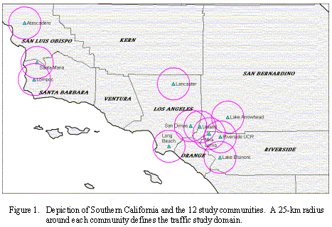
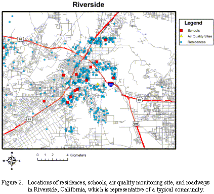
The CHS is in its eighth year of field operations with 2476 actively participating subjects. The CHS is being conducted within 12 geographically defined communities in Southern California, ranging from Atascadero in San Luis Obispo County to Alpine in San Diego County. The participating communities were selected to represent a wide range of air quality conditions. Figure 1 shows the 12 communities and the 25-km radius around each community that defines the traffic study domain. Figure 2 shows the locations of residences, schools, and roadways in Riverside, California, which is a typical community. The locations of residences, schools, and air monitoring stations were geo-coded to examine the spatial distribution of study participants and school locations within each of the 12 study communities.
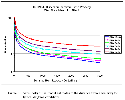
The accuracy of the geo-coding is quite important because, for a given amount of traffic and specific meteorological conditions, the effects of roadway emissions on exposure are critically dependent on the distance between the roadway and the receptor. Figure 3 shows the sensitivity of the model estimates to distance from the roadway for typical daytime conditions.
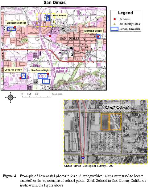
The geo-coding process results in a single point location for each residence and school. In most cases, the school locations were geo-coded to an individual building on each campus based on the mailing address of the school. For modeling purposes, we are interested in school locations because this is where children spend a large amount of time, and may be exposed to different environmental conditions and traffic pollution depending on the proximity of the school yard to surrounding roadways. Because exposure to traffic depends strongly on distance to the sources, it was important to determine the boundary and center of each school yard. Aerial photographs and topographical maps obtained from the United States Geological Survey (USGS) were used to verify the locations of the schools and to digitize the school boundaries. Figure 4 shows an example of how aerial photographs and topographical maps were used to locate and define the boundary of each school yard.
The California Department of Transportation (Caltrans) annual average daily traffic (AADT) volume data set was implemented to create the road network maps and determine the traffic activity in each of the 12 communities. The AADT volumes are estimated from traffic count data collected every three years on the moderate and larger surface streets and collected continuously (every 30 seconds by lane) on the major freeways. Volumes on the smaller streets are either omitted or estimated from more approximate relationships in the Caltrans database. They include both the Caltrans state highway data and the local county traffic agency’s traffic volumes.
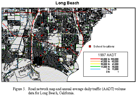
ArcInfo was used to generate road network maps and to display and quality assure the AADT data. For example, a quality assessment was made to closely examine the AADT data in each of the 12 communities. There were road links in each community where the AADT value reported was inconsistent with surrounding links. In these instances, the data were flagged and the value was replaced by a more accurate estimate. Figure 5 shows a road network map and AADT data for Long Beach, California.
The AADT volumes are annual data. An important element of the approach was the estimation of the diurnal and day-of-week variations of the traffic from the annual average. The diurnal distribution of weekday and weekend traffic patterns was obtained from the real-time traffic monitoring data. The Caltrans weigh-in-motion data were used to obtain separate estimates for the light-duty vehicles (mostly gasoline-fueled) and heavy-duty vehicles (most diesel-fueled) also considered in the traffic exposure modeling. There are two principal diurnal distributions of weekday and weekend traffic volumes in Los Angeles County with morning and afternoon peaks on weekdays and afternoon/evening peaks on weekends. Figure 6 shows the diurnal distributions of weekday and weekend traffic volumes in the Southern California region.
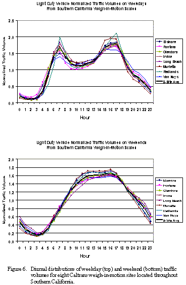
The average Saturday and Sunday patterns have only one broad afternoon peak. The profiles shown in Figure 6 were compiled from the Caltrans weigh-in-motion data and are consistent with traffic patterns derived from cluster analysis of diurnal data from 1600 freeway monitors (Niemeier et al., 2000). The diurnal distributions show a significant number of hours with low traffic volumes before and after the hours with the high traffic volumes, suggesting that there is a seven-fold difference in hourly volumes from the early morning to the morning or afternoon peaks. The combination of the diurnal variations in traffic volumes and the meteorological conditions greatly enhance concentrations at selected hours, such as during the morning rush hours.
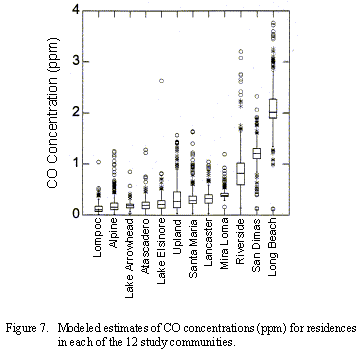
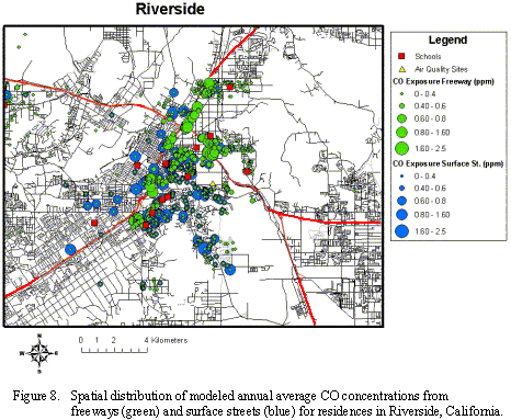
The CALINE4 dispersion model was applied using the AADT data for all links located within 25 km of the center of each CHS communities. The model was applied for 256 hourly cases representing different wind speeds, wind directions, and atmospheric stabilities. The hourly concentration results from these simulations were then weighted by their long-term frequency of occurrence to construct the annual average concentrations, based on meteorological data for each community. Annual average concentrations were estimated for CO, NO2, and PM with aerodynamic diameters up to 2.5 µm, and between 2.5 and 10 µm. Figure 7 shows the range of CO estimates for residences in the different communities. Figure 8 shows the spatial distribution of annual average CO concentrations in Riverside.
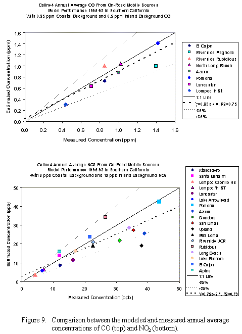
The accuracy of the estimated concentrations was assessed by comparing measured data with model estimates of concentrations at air monitoring stations within the communities. Figure 9 shows a comparison between the model estimates and measured annual average concentrations of CO and NO2. After modest background concentrations are incorporated to represent coastal and inland background levels, the model provides estimates that are within ±35 percent of the measurements and shows reasonably good correlation (R2 = 0.75 for CO and R2 = 0.79 for NO2). These results are encouraging, but more work is needed to assess the accuracy of the approach. The approach is worthy of further refinement based on these evaluation results and preliminary cross-sectional analyses that indicate associations between various health end points and the estimated exposure to mobile source emissions.
Traffic exposure modeling is an iterative process resulting in hundreds of output data files. In order to organize, archive, and display each traffic exposure episode, a geodatabase was created using Microsoft Access. The output from each exposure model run can be easily imported into the geodatabase using pre-defined import specifications. The exposure model data files can then be joined to the ArcInfo base maps and feature class files are generated within the geodatabase. This provides a standard method for importing and displaying the model output in a systematic and organized way. Another benefit of using the geodatabase is the capability of easily manipulating data files through the use of queries.
Considerable refinement and extension of the exposure modeling is anticipated. The principal elements include (1) refinement of the vehicle emission factors to utilize the latest information from the EMFAC2000 mobile source emission rate model, (2) improvement of the gasoline-vehicle/diesel-vehicle splits, (3) evaluation of the traffic volume data, (4) comparison of the model estimates with NO2 samples collected at 280 residences in the different communities, and (5) expansion of the traffic domain to include all of Southern California. All of these elements are intended to validate the methods and make model results available for use in other health effects studies. Another option being explored is integrating CALINE4 and ArcInfo to develop a semi-automated GIS-based modeling tool.
The authors wish to thank the staff at the California Department of Transportation for providing traffic data and documentation. We gratefully acknowledge the financial support of the California Air Resources Board (ARB). This work was conducted under a subcontract from the University of Southern California’s Keck School of Medicine, Department of Preventive Medicines to Sonoma Technology Inc. for exposure-related work on the Children’s Health Study. The statements and conclusions in this paper are those of the authors and not necessarily those of the ARB.
Benson P. (1984) CALINE4 - A dispersion model for predicting air pollution concentrations near roadways. Final report prepared by California Department of Transportation, FHWA/CA/TL-84/15, November, Revised November 1986 and June 1989.
Brunekreef B., Janssen A.H., de Hartog J., Harssema H., Knape M., and van Vliet P. (1997) Air pollution from truck traffic and lung function in children living near motorways. Epidemiology 8, 298-303.
Gauderman W.J., McConnell R., Gilliland F., London S., Thomas D., Avol E., Vora H., Bethane K., Rappaport E.B., Lurmann F., Margolis H.G., and Peters J.M. (2000) Association between air pollution and lung function growth in Southern California children. Am. J. Respir. Crit. Care Med. 162, 1383-1390.
McConnell R., Berhane K., Gilliland F., London S.J., Vora H., Avol E., Gauderman W.J., Margolis H.G., Lurmann F., Thomas D.C., and Peters J.M. (1999) Air pollution and bronchitic symptoms in Southern California children with asthma. Environmental Health Perspectives 107, No. 9, September, 757-760.
Peters J.M., Avol E., Navidi W., London S.J., Gauderman W.J., Lurmann F.W., Linn W.S., Margolis H., Rappaport E., Gong H., and Thomas D.C. (1999) A study of twelve Southern California communities with differing levels and types of air pollution, 1. Prevalence of respiratory morbidity. American Journal of Respiratory and Critical Care Medicine 159, 760-767.
Niemeier D., Hicks J., Korve M., and Sung-Eun K. (1999) Estimation of Allocation Factors for Disaggregation of Travel Demand Model Volumes to Hourly Volumes for Highways in the South Coast Air Basin. Report prepared for the Air Resources Board.
Studnicka M., Hackl E., Pischinger J., Fangmeyer C., Haschke N., and Kuhr J. (1997) Traffic-related NO2 and the prevalence of asthma and respiratory symptoms in seven year olds. Eur. Respir. J. 10:2275-8.
van Vliet P., Knape M., de Hartog J., Janssen N., Harssema H., and Brunekreef B. (1997) Motor vehicle exhaust and chronic respiratory symptoms in children living near freeways. Environ. Res. 74:122-32.
Wyler C., Braun-Fahrlander C., Kunzli N., Schindler C., Ackermann-Liebrich U., and Perruchoud A.P. (2000) Exposure to motor vehicle traffic and allergic sensitization. The Swiss Study on Air Pollution and Lung Diseases in Adults (SAPALDIA) Team. Epidemiology 11:450-6.
Tami H. Funk