GIS: A Modeling Tool to Answer Critical Area Questions
Abstract: This presentation illustrates the use of different GIS tools to enhance critical areas information (e.g., wetlands and steep slopes) for the Pierce County Buildable Lands Program. The program's overall purpose is to determine the amount of developable land within Pierce County and its cities and towns to meet future population needs. To calculate the developable lands, critical areas need to be deducted. In past analyses, the County has relied on various sources of information to justify its critical areas deduction. The accuracy of these sources has been questioned. The presentation will outline a modeling exercise and tools used in conjunction with existing critical area information to validate it.
In 1990 and 1991, the State of Washington passed a law known as the Growth Management Act (GMA). The GMA required the fastest growing cities and counties in Washington State to adopt comprehensive plans and implementing development regulations. These comprehensive plans and development regulations are required to contain a number of mandatory elements and must conform to the policies and guidelines in the GMA. One of the mandatory elements in this planning process was the identification of critical areas that required protection or buffering from future land development. Each jurisdiction that was required to plan was required through a review and approval process to plan for accommodating its reasonable share of population growth over a 20-year planning period.
In 1997 the State of Washington passed a law modifying the GMA. This law requires a review and evaluation procedure to determine if local jurisdictions are achieving the urban densities within their urban growth areas mandated by their comprehensive plans and the GMA. This law is codified as RCW 36.70A.215 Review and evaluation program. The law also requires the creation of a buildable land inventory and an evaluation of the capacity of the land within the urban growth area (UGA) to accommodate the projected population under the development regulations that have been adopted pursuant to GMA and the local comprehensive plan. This process mandates a detailed evaluation of critical areas to the extent necessary to determine the quantity and type of land suitable for development.
Pierce County, Washington is required to plan under the GMA. Pierce County's comprehensive plan and development regulations include the required elements that protect and regulate critical areas. The general location of areas that are probable locations of wetlands and steep slopes have been mapped by a variety of methods, and are represented by coverages in the Pierce County GIS. The current information within the GIS coverages is not adequate to complete the buildable land inventory required by the State.
These existing coverages are scheduled to be replaced by more detailed and more accurate coverages of steep slopes and wetlands. This paper describes the methodologies being used to evaluate existing data to create these new (more accurate) coverages.
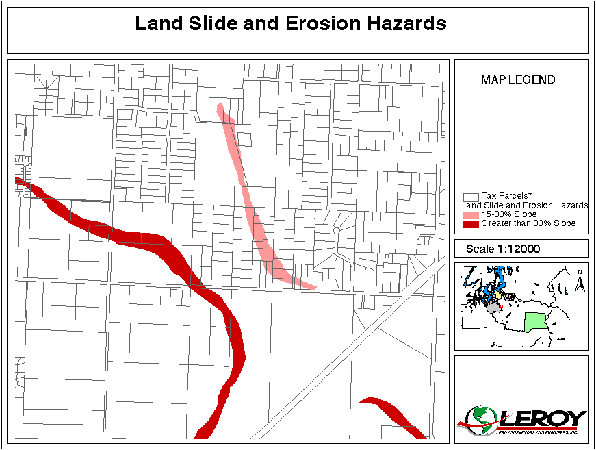
The existing steep slope data on the Pierce County GIS system is contained in the Landslide and Erosion Hazards coverage. This data was taken from the SCS soil classification coverage that was digitized into the GIS and geo-referenced to the parcel layer, but the parcel layer is substantially off from State Plane Coordinates in many locations. Because this existing data is not very reliable, it frequently requires permit applicants to prepare topographic surveys or geotech reports where they would not otherwise be required.
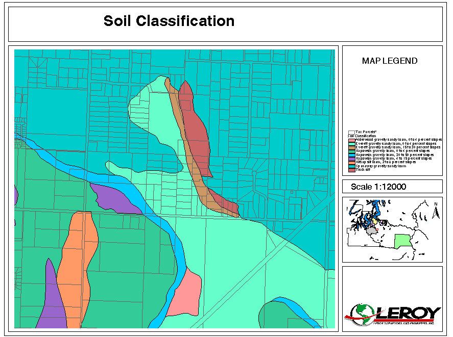
Pierce County currently has a parcel based database that allows staff to query a parcel to see if it contains slopes greater than 15% or greater than 30%. The data was generated by categorizing the SCS soil types by general slope characteristics, and then selecting the parcels that contain soils mapped for the respective slopes. This information does not allow for any determination of the amount of land within the parcel that is impacted by the soil type that indicates the probable steep slopes.
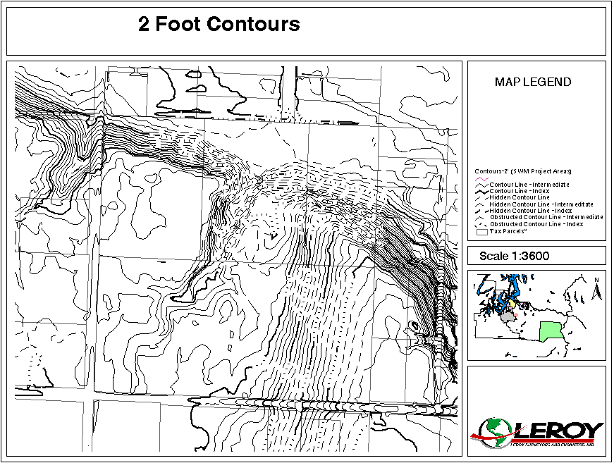
Most, if not all, of the area within the UGA of Pierce County and its municipalities now has 2 foot interval contour information with dtm surfaces comprised of points and breaklines available from the vendor. Utilizing the dtm surfaces that were used to create the contours and tools in Spatial Analyst, we have categorized the slopes in 5 percent intervals from 0–100%, keeping in mind that 10 feet of vertical relief is required to make a slope significant according to Pierce County Ordinance.
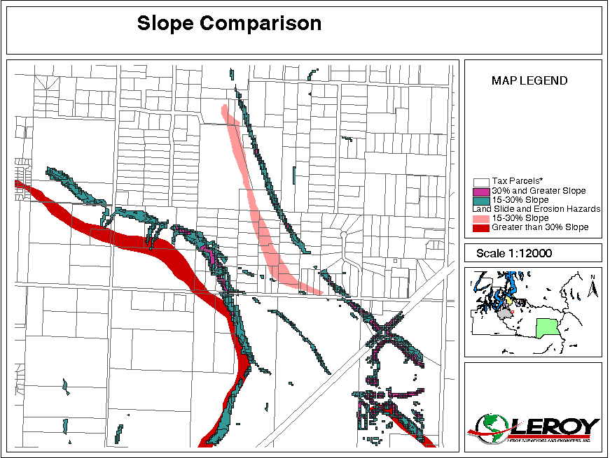
Now we can overlay the slope categorization over the currently used landslide and erosion hazard coverage that was derived from digitizing soils data. As you can see in Figure 5 the old coverage was generally of the correct shape, but it was poorly georeferenced to the true horizontal location of the steep slopes.
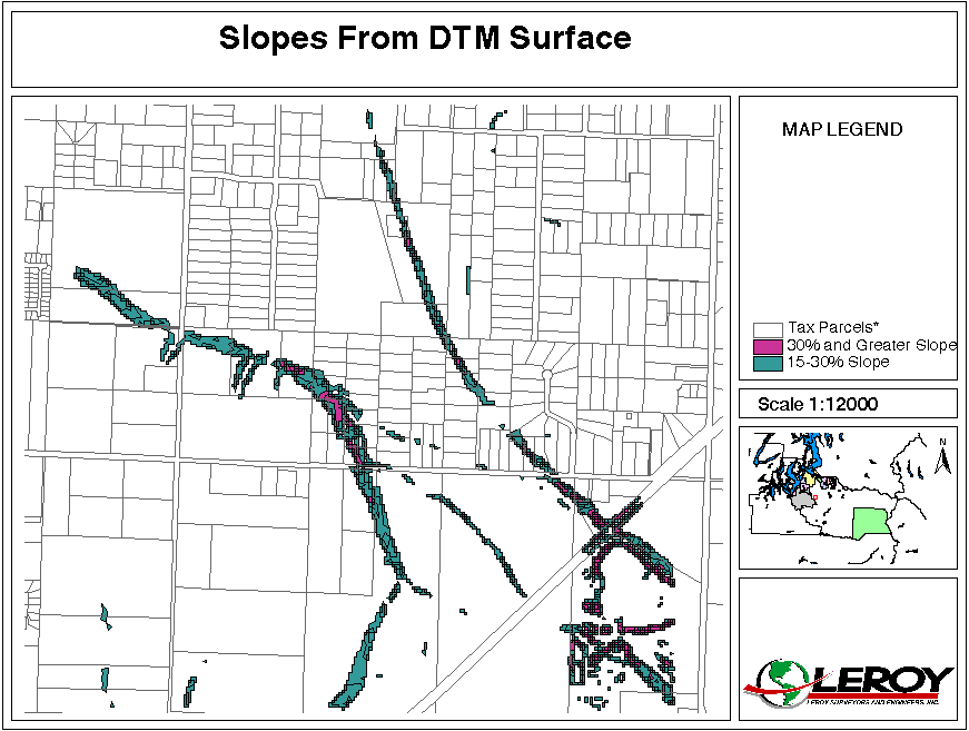
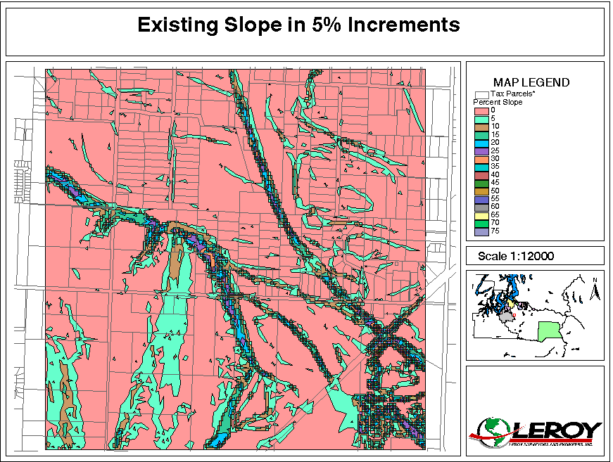
The final product delivered to Pierce County by LeRoy Surveyors & Engineers has the slopes categorized in 5% slope increments to allow for more detailed analysis of the impact of the slopes on the buildable land inventory. Figure 6 illustrates this detailed data.
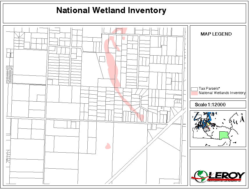
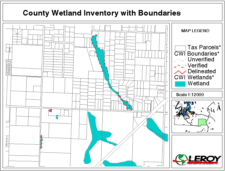
The existing wetland data on the Pierce County GIS system is contained in two coverages. One is the National Wetlands Inventory and the other is known as the County Wetlands Inventory. Both of these coverages are based on digitized information that has been rubber sheeted to the parcel layer. As previously mentioned, the parcel layer is poorly georeferenced to the contour information and color orthophotos.
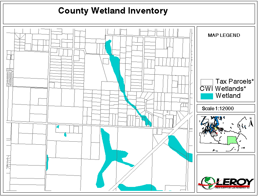
The County Wetland Inventory also includes a boundary coverage that indicates whether wetlands are unverified, verified or delineated.
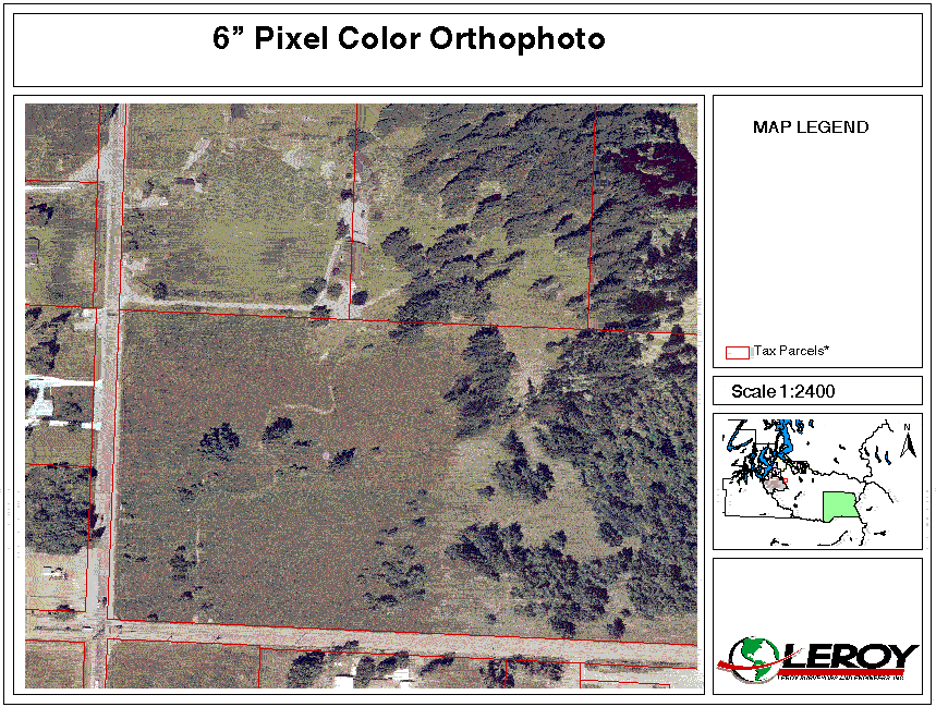
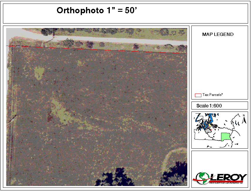
Pierce County now has coverage of the urban growth boundary with 6" pixel color orthophotos. These photos can be used to help determine the location of wetland boundaries. The photos in Figures 10 and 11 are lacking in detail due to the limitations of 72 dpi in this presentation.
We used the Terramodel program from Plus 3 to overlay contours and dtm information over the color orthophotos. We then located depression contours to identify potential wetland locations and interpreted the vegetation in the orthophotos within the depressions to predict wetland locations.
The wetlands that we have predicted using this modeling technique have been spot verified in the field to determine the accuracy of the modeling effort. We have found that the wetland locations predicted by this technique are in very good agreement with actual field delineations in the portions of the County that are not heavily forested. Unfortunately, this methodology has been hit and miss with respect to accuracy within the forested areas, but it does accurately predict the approximate magnitude of wetland area. This will make the inventory very useful for determining the amount of buildable land within the urban growth boundary. We should note that we are finding many wetlands that were not depicted in the existing GIS coverages. We have also found a number of wetlands in the existing GIS coverage that are not wetland areas.
Figure 12 illustrates the wetlands that were modeled in the non-forested areas of a portion of the same study area we depicted in earlier figures. The figure also shows some wetlands that were not modeled but that were identified in the field during field verification. These non-modeled wetlands were in a sloping wooded area fed by seeps without depressions. You will note that some of the modeled wetlands were less than 2500 square feet and will be non-jurisdictional. You will also note that the Pierce County Wetland Inventory only showed a small fraction of the actual wetlands in this study area.
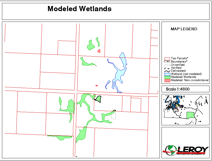
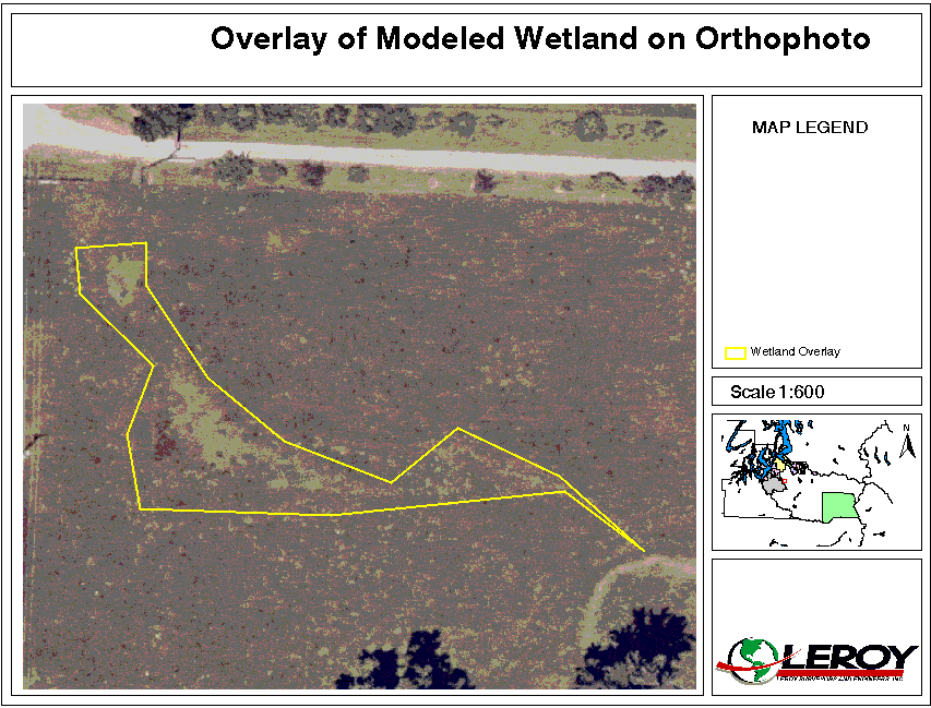
Figure 13 illustrates one of the modeled wetlands overlaid on the color orthophoto.
The methodology that we have used to better define steep slopes for use in the buildable land inventory process has been very successful. The new steep slope coverage is relatively accurate and is georeferenced very well to the orthophotos and Washington State South Zone State Plane Coordinate System. The landslide and erosion hazard coverage that it will replace was very poorly georeferenced and was not useable in any type of parcel based analysis of available buildable land. The current parcel layer coverage will need to be more accurately georeferenced in some parts of the county to make it useable for analysis with the new slope and wetland coverages.
The methodology that we used to better define wetlands for use in the buildable land inventory has been very successful in the areas that are not covered with heavy vegetation. The methodology predicts additional wetlands in the forested areas, but the locations and sizes of these wetlands are not nearly as accurate as they are in the more open areas. The inaccuracy of the dtm surfaces in the wooded areas is the primary culprit in the available data which prevents more exact modeling results of these areas. The future availability of better dtm surfaces in wooded areas by use of LIDAR will allow this methodology to produce more precise results.
1RCW 36.70A.215
Review and evaluation program.
RCW 36.70A.215 Review and evaluation program
Title 19A, Comprehensive Plan, Pierce County, Washington
Title 18E, Development Regulations - Critical Areas, Pierce County, Washington
The Growth Management Act (GMA) (RCW 36.70A)
State planning guidelines (WAC 365-195)
|
Author: Paul E. Green, P.E. Engineering and Land Use Manager LeRoy Surveyors & Engineers, Inc. 1103 Shaw Road, Puyallup, WA 998372 USA Phone: 253-848-6608, Fax: 253-840-4140 paul@lseinc.com |
|
Author: Suzanne Bagshaw, Ph.D. Wetland Biologist LeRoy Surveyors & Engineers, Inc. 1103 Shaw Road, Puyallup, WA 998372 USA Phone: 253-848-6608, Fax: 253-840-4140 suzanne@lseinc.com |
|
Author: Neng Yu, Ph.D. Environmental Scientist LeRoy Surveyors & Engineers, Inc. 1103 Shaw Road, Puyallup, WA 998372 USA Phone: 253-848-6608, Fax: 253-840-4140 neng@lseinc.com |