
Donna Wendt
Abstract:
“Destination Downtown” is a project managed by the Tacoma Economic Development Department. More than a plan, it is an active implementation of a strategy that involves simplified zoning, siting and implementation of light rail, mixed uses, housing, transit, street level activity, and aesthetic improvement. The paper describes how an experienced GIS team put together analysis to help bring this project to reality. For feedback in the process of economic development in downtown Tacoma, GIS is used as a front-end to outcome measurements.
This paper was presented on July 11, 2001.
Introduction
The style of urban planning has been changing to meet the demands of our current society. In the past, long-range plans were produced and change was gradual. The pace of life is much faster now, and along with it expectations for local government performance have increased. The bias has shifted to a more results and action oriented business plan. The mission for the Tacoma Economic Development Department is:
Plan Fast,
Act Now
To stimulate the economy."
Four goals related to this mission are:
* Strengthen the Heart of the City
* Establish Tacoma as a Destination City
* Enhance Neighborhood Livability
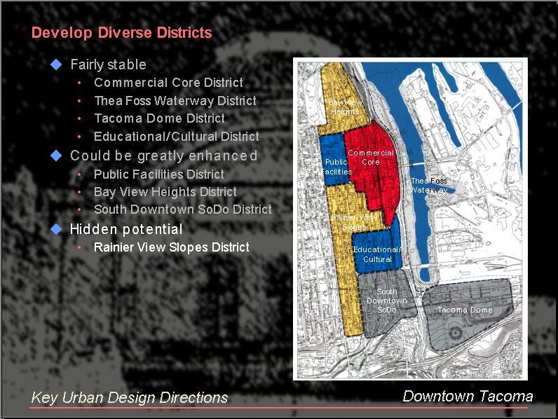
Overview of Downtown Tacoma Development Strategies
The key downtown Tacoma development strategies are:
Several awards for the marketing of Tacoma have been realized:
Pending award nominations are:
www.TacomaSpace.com, shown below, is an interactive GIS web site to promote the sale and lease of business space in downtown Tacoma. It has received four awards, including first place in the 2000 international Esri conference in San Diego, ArcView IMS category, and the GIS application award from the Washington State Chapter of URISA.
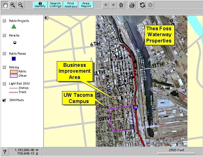
The 1998 digital ortho photo used in TacomaSpace.com was produced by Triathlon, Inc. and is stored in MrSid format for Internet query use.
Nurture unique neighborhood character, build housing, increase density, and adapt older structures to housing. Current loft housing is very popular and has a waiting list.
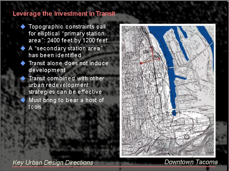
Leverage the Investment in Transit: Five light rail stations will be completed in 2002. The one-way streets have been restored to 2-way as of May 2001. Key intersections will be enhanced, and mid-block crosswalks will encourage pedestrian use.
Travel analysis has been done on key arterial corridors.
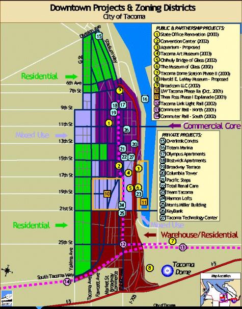
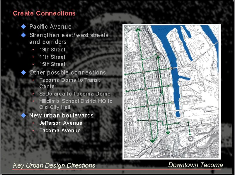
Key development projects in the downtown area.
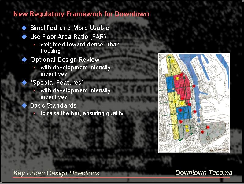
Zoning regulations have been simplified to encourage development. Housing incentives will bring more people into the district, and new requirements for urban design will increase the quality of development.
Further GIS Analysis for Destination Downtown
As evidenced by the above illustrations describing the planning elements of the downtown plan, GIS analysis is a part of the total project, not something done on the sidelines. This section will provide feature additional mapping analysis that was part of Destination Downtown.
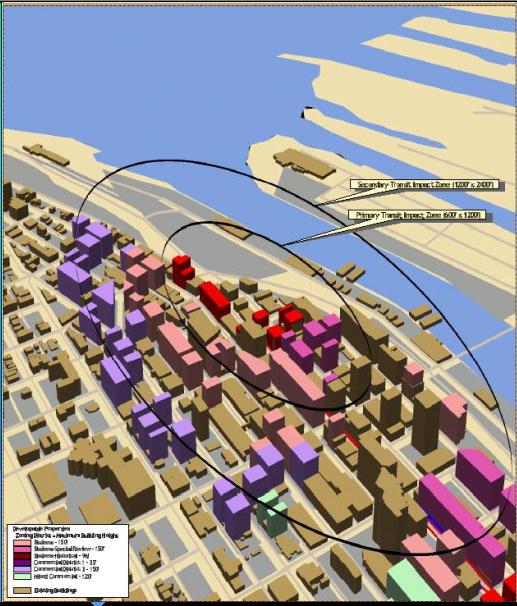
Analysis of total build out for new zoning regulations was displayed with ArcView 3D Analyst.
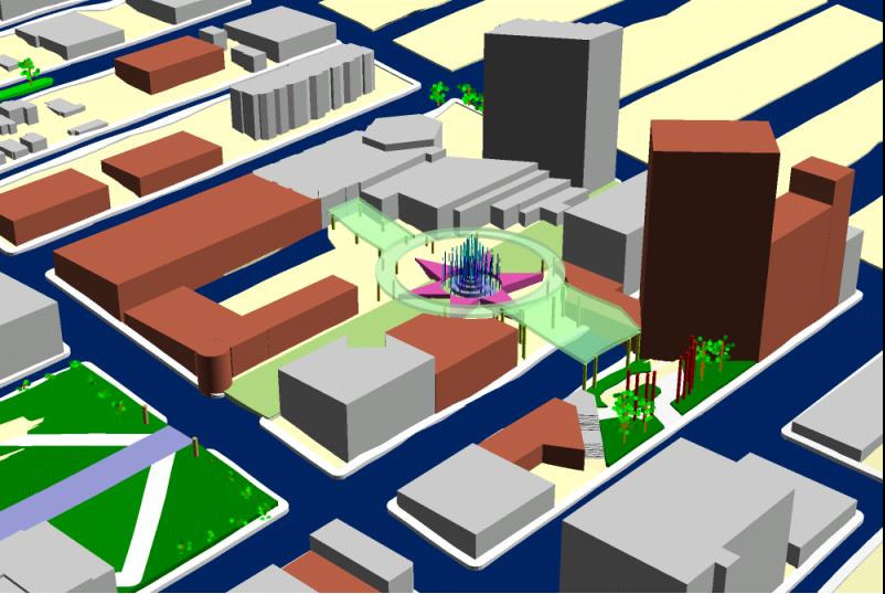
A team of planners and architects designed this area of the downtown that includes the new convention center and hotels. ArcView 3D Analyst was used to visualize their design. The new hotel was situated to take full advantage of the view of Mt. Rainier without obstructing the view from the existing hotel.
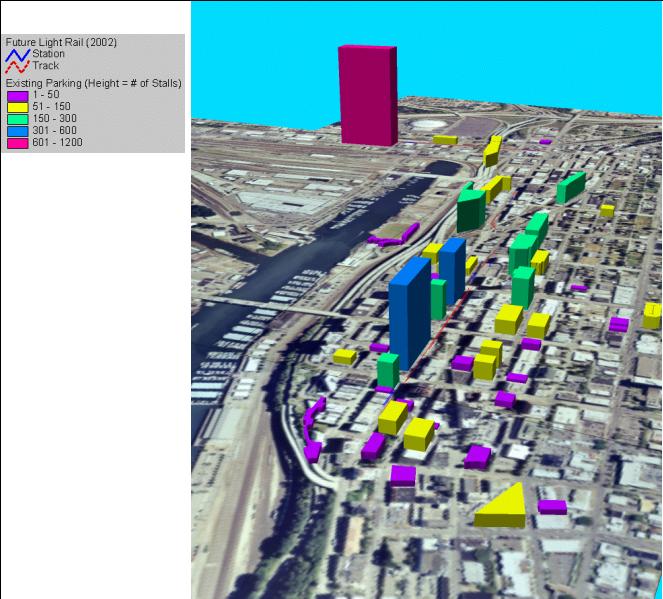
ArcView 3D Analyst was used to represent parking capacity by height. The large red figure represents the parking capacity of the newly constructed transit parking garage. The proposed light rail line shown in red will tie the downtown and Tacoma Dome districts together and will maximize the use of the available parking spaces.
Community Measures
The challenge with outcome measures is that they are often not only influenced by the work of a single agency, but of many agencies and market forces. It is difficult to gauge the productivity of a single government department by them, although they may be more relevant to results than activities, numbers of meetings, inches of report produced, etc. However, the data can show the trends of a neighborhood, and department action plans can be modified based on these outcomes. Key outcome indicators associated with the mission and goals listed above include:
Some of the measures associated with these indicators will be included in this paper. The data from the following charts were derived using ArcView as a front end to spatially select the related data, such as permits located in the downtown study area, or parcels tied to assessor real property and sales records.
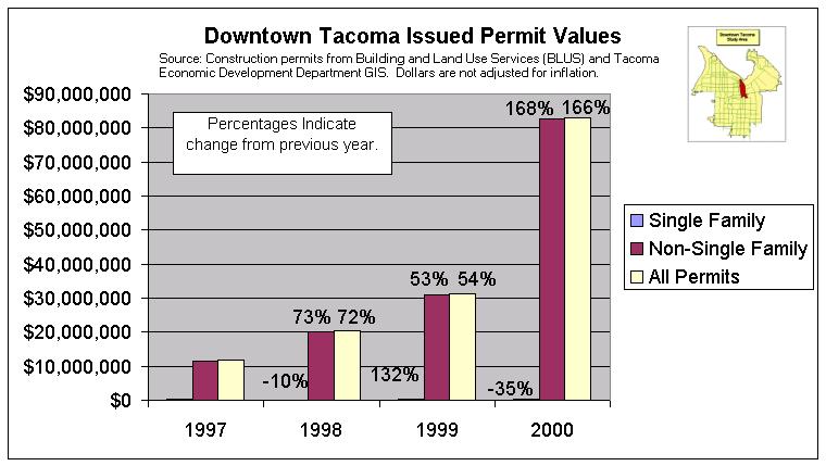
The following charts show strong growth in downtown Tacoma. The increase in permit projects reflects the incredible development taking place. Permit amounts are the values of the construction projects being undertaken.
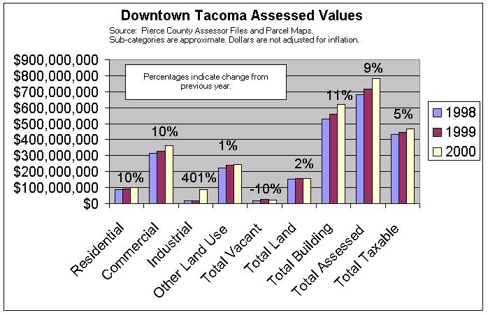
Assessed values show increases when construction projects indicated by the permit records are completed. Future additional increases in assessed value are expected at the completion of the multi-year construction projects.
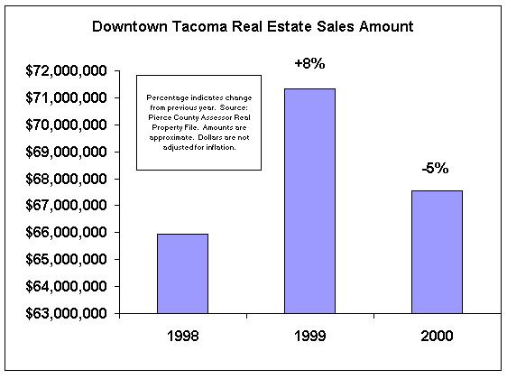
Real estate sales reflect more a level of turnover of property, but also can indicate a level of economic activity and investment. Activity appeared especially high in 1999 due to two very large individual sales at $28M and $13M, but the level of activity in 2000 is also high in comparison to 1998. More years of data are needed to show the general trend for real estate sales.
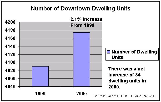
Dwelling unit counts are kept as a GIS theme updated by permit records. The increase in numbers of dwelling units is in line with downtown area goals.
According to statistics produced by the Puget Sound Regional Council, employment in downtown Tacoma has increased 2% from 1998 to 1999. The statistics are tabulated by census tract and facility area zone and approximate the downtown study area. Additional years of data will be needed to show trends, but the one-year increase in employment is a good sign.
Future Plans
The annual measurements will continue with some additions of comparison benchmarks from other cities, counties, and states as they become available. The implementation of Destination Downtown is well underway, but there are additional goals to be met, such as an ambitious schedule for increase in dwelling units. In 2001, the Tacoma Dome Area Plan is being updated and measures for that area will be instituted. The City of Tacoma is part of the CommunityViz (TM) beta software program from the Orton Family Foundation, and the economic modeling provided by that software will dovetail well with the current outcome measures. Continued development in that area will complement the downtown projects and will tie together into a cohesive vibrant place that is good for business and entertainment alike.
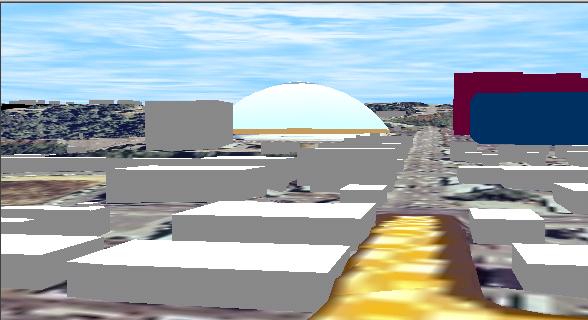
A 3D look into the future of the Tacoma Dome area using CommunityViz (TM) TownBuilder3D. For more information refer to www.Orton.org.