URL: http://www.ci.tucson.az.us/ed/ed.htm
The City also realized that there was no accurate inventory of all the commercial properties in the city. While many larger communities have comprehensive commercial multiple listing services (MLS), Tucson's commercial MLS is extremely limited. This made it difficult for economic development organizations and private realtors to assist businesses in locating available commercial space in Tucson.
It was clear early on that a web-based geographic information system (GIS) solution was needed. No other solution could bring together such a wide variety of data to give a clear picture of the commercial property. The challenge for the City, then, was to create a tool that was useful to City government, local real estate companies and businesses considering locating in Tucson.
While smaller communities have web sites that provide the equivalent of a MLS for their area, Tucson set out to build an economic development and community planning system. To do this, the city partnered with Pima County, the area's largest economic development organizations, the State of Arizona and the commercial real estate community.
Because of the foundation work done by the City of Tucson's GIS Cooperative, Tucson and Pima County were already sharing orthographic-photo and base map databases of the entire valley, as well as standard parcel addresses and other data layers. The economic development office and their consultant, GIS Planning, built on this to create Tucson's Commercial Property Online (TCPO).
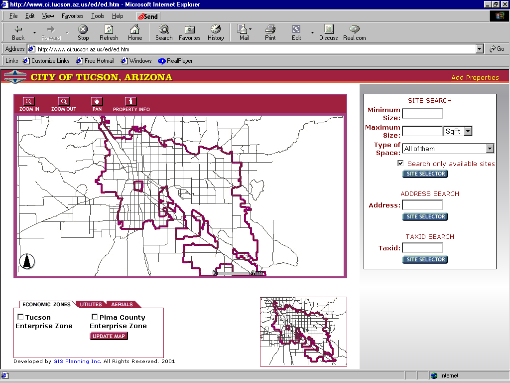
TCPO is a web-based GIS solution built using ArcIMS, HTML, JavaScript, and Active Server Pages. The first version, now available through the City's web site at http://www.ci.tucson.az.us/ed/ed.htm provides the following capabilities:
The target audiences of this program are prospective businesses, expanding companies, real estate developers, and real estate professionals including brokers.
Early response to the system has been overwhelmingly positive. For the first time, real estate brokers and economic development organizations are provided a comprehensive view of the commercial property in Tucson. The City's OED is able to view and analyze the factors that contribute towards commercial property remaining vacant and begin addressing these. Real estate brokers are able to offer better, more comprehensive services to their business customers.
In the past, when a company would inquire about space in Tucson, a call or a fax would go out to each broker with the specs that the company was looking for. The brokers would then return their information that would be sent to the client. After the client received the information about the available spaces, further research would be done about the demographics and other characteristics of the property. Now, this can all be done at one time. It also appears that today, many companies are choosing to complete "Phase I" searches of communities and short list them by internal processes. Companies are not contacting local organizations until this short list is developed and they have very specific questions about the prospective community. This system puts much of the basic information that a company is looking for in one place, thus making it easier for them to determine whether or not Tucson is the right location for them.
This system has also increased staff productivity in a number of ways. Staff is now able to search for property and get results very quickly. Historically, response times to telephone inquiries were one or two days. Now this can be done as the initial phone conversation is occurring. This provides better service for our clients and a reduced workload for City staff. By providing this "Phase I" information rapidly, the staff can focus better on ensuring that the client chooses Tucson as a new location for their business, or chooses to remain in Tucson to expand.
All information is updated online and in real time. Through a simple-to-use web page, real estate brokers access an online form to update the information. As soon as they fill out the form, the property is geocoded and added to the system. Because it is a web site application, real estate brokers can add, delete or edit any property at any given time. They can also submit pictures for any property through their own browser interface.
All the information for decision making is at one location. Property reports, business information, market analysis and demographics can all be found at the same web site. This results in the benefit of a centralization of data with a decentralization of access, which is an optimal environment for business attraction site-selection.
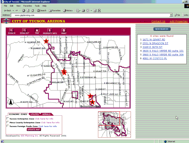
After the user clicks on the "site selector" button, the application searches its database for all properties matching the user-defined property requirements. The server sends back a list of buildings that match the requirements as well as a map showing the selected spaces. Locations are numbered on the map and correspond to the numbered text list found on the right side of the screen.
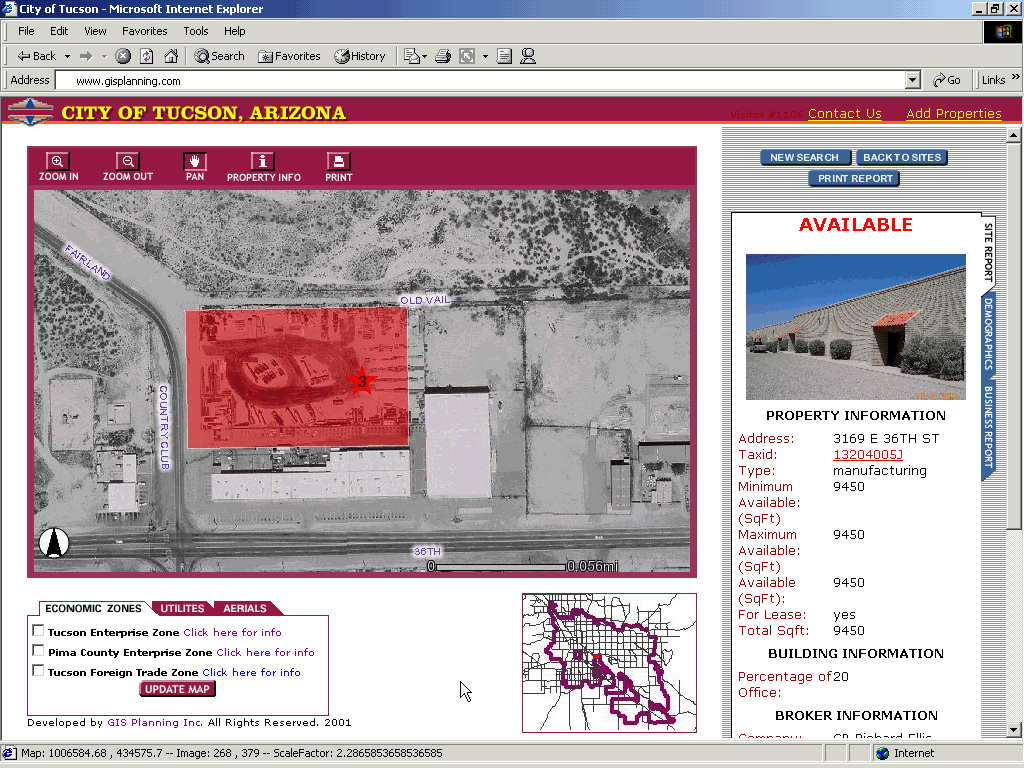
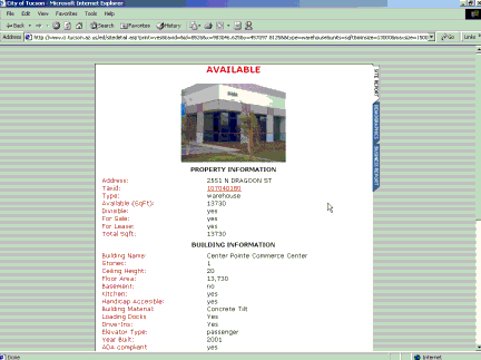
By clicking on any of the list of available properties the server generates a new map showing the property and a detailed property report. This report includes property, tax, building, and broker information as well as a photo if submitted by the broker. The information found within the reports comes from different databases (available property, parcel & brokers).
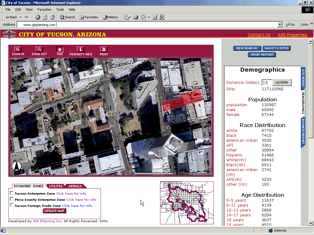
After selecting a space, you can get a report about the demographic, economic and business characteristics of the area surrounding the property. The web site visitor simply clicks on the file tab marked "demographics" and a new demographic report will be generated.
ArcIMS selects all the census block groups within that distance and summarizes the demographic information. The results of the report will be displayed in the frame on the right side of the screen. The default distance for reports is 1 mile from the property. The user can easily change this by typing in the specific demographic report distance in miles for which they would like a demographic report. (Note: the picture and demographic report image displayed below is for a different property than shown in the site selection description. It is used to show the inclusion of color orthographic aerial photography also used in the application that visually displays spatial relationships in a realistic view).
TCPO is the first web-based GIS application for economic development that provides interactive mapping of businesses. This allows a prospective business the ability to view spatial relationships of businesses by industry - a critical component of the site selection process. The user can also "drill-down" through links to view specific company information.
By clicking on the "Business Report" file tab from the property or demographic report, ArcIMS gathers all of the businesses within the user-defined distance and presents the businesses by industry in a report format. The map will thematically show the different businesses that are identified by different colors.
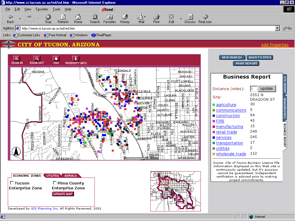
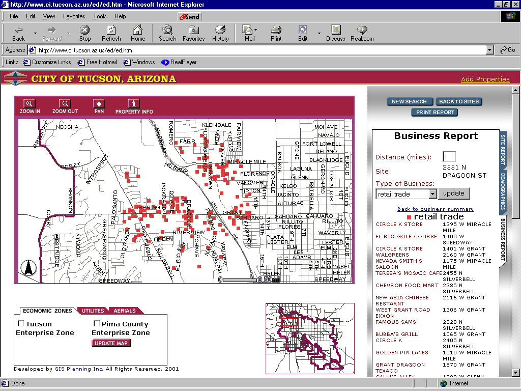
If the user is interested in industry specific information, he or she can click on the specific industry. A new report shows the names and addresses of all of the businesses in the industry category. The map, then, only shows the locations for that specific business industry.
By clicking on the "print report" button, the application opens a new print-friendly property report that includes property information, building information, real estate broker contact information, links to detailed tax information and a picture of the property if available. Even the print friendly reports are interactive, allowing the user to create demographic and business reports by clicking on file tabs.
After clicking on the "Add Properties" link located at the top right-hand corner of the web page, each Real Estate Broker must enter their login and password.
After logging on through the login and password the real estate professional is taken to a web page showing all of his or her commercial properties.
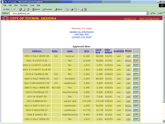
From this page the broker can update his or her information, add a new site, or edit an existing site.
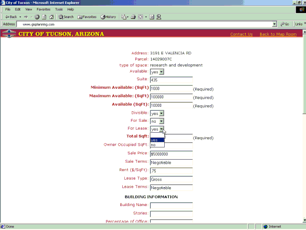
Real estate brokers can add a new space at any time. As soon as they click on "submit" after they have completed the form, the space is geocoded and added to the staff's accept/reject available commercial property database. Real estate brokers can see the list of all the spaces they have. They can also identify their properties as "no longer available" when a property has been leased or sold. All of these features are performed using ArcIMS and Active Server Pages. Real Estate Brokers can edit information for any property at any given time.
Like the broker database access, the staff web site is available through a login and password system. Staff can add/modify/delete any property at any given time.
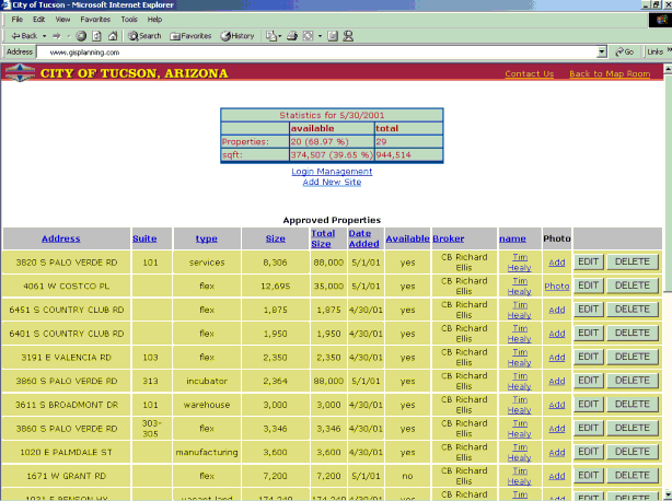
Along with the listing of all properties, staff has access to property statistics. Staff can also sort properties by the various headers including address, suite, type, size, total size, date added, availability, broker and photo. This allows the database to not only be a listing of all properties but also a useful tool for analyzing data.
The site includes a secure on-line form for City staff to add a new broker to the system as well as approve or reject all broker-submitted sites. (The broker information is stored in an Access Database). City staff can also modify any login and password at any moment as well as delete a real estate broker from the database. The real estate broker information is linked to each of the sites.
Computer Systems:
Client:
Web Server:
Map Server:
Data
Russell Ribblet
Business Development Specialist
City of Tucson Office of Economic Development
Phone: (520) 791-5093
rriblet1@ci.tucson.az.us
Pablo Monzon,
CTO, GIS Planning.
1-888-682-3583
monzon@gisplanning.com
www.gisplanning.com