Quantifying spatial position of wetlands for stream habitat quality prediction
S Stark, N Detenbeck, and S Batterman
ABSTRACT
A watershed’s capacity to store and filter water, and the resulting effects on the hydrologic regime, is a key forcing function for instream processes and community structure. However, methods for describing wetland position have traditionally been qualitative. A Geographic Information System provided an efficient means of describing wetland connectivity, area, type, and position in 20 2nd order streams of the western Lake Superior basin by estimating proximity-weighted wetland area using distance from sampling points to wetlands. This information, coupled with estimates of overall wetland extent, will be used to assess the moderating influence of wetlands with respect to land-use effects on stream condition.
One of the simplest relationships established between landscape structure and function is the differential production of sediment, nutrients, and runoff from different land-covers and land-uses. Omernik (1976) has empirically demonstrated the relationship between percentages of different land-uses in a watershed and stream or river water quality. Johnston et al. (1990) and Osborne and Wiley (1988) have confirmed the importance of the relative position of land-use patches serving as sources or sinks in watersheds on downstream water quality. Johnston et al. demonstrated that watersheds with relatively greater wetland area had lower conductivity, chloride, and total lead in streams at watershed outlets. In addition, streams draining watersheds with wetlands located nearer the watershed outlets had relatively lower levels of inorganic suspended solids, fecal coliform, nitrates, conductivity, flow-weighted ammonia, and flow-weighted total phosphorus concentrations. Likewise, lakes with proximal wetlands in the watershed had relatively lower trophic status than did lakes with more distant wetlands (Detenbeck et al. 1993). Osborne and Wiley (1988) developed empirical relationships between water quality variables and land-use within different buffer distances from rivers, and used these to simulate the effects of changing land-use on water quality.
The Mid-Continent Ecology Division of the EPA in Duluth, Minnesota is addressing differences in response of water quality function and instream community structure/function attributes between watersheds in two contrasting, hydrogeomorphic landscape units (the North Shore Highlands and Lake Superior Clay Plain). The two landscape units have been examined under conditions of high and low inland wetland + lake coverage (representing storage/buffer capacity) and under conditions of high and low anthropogenic disturbance (land clearing/logging/fragmentation). A subproject of this larger framework is focused on the effects of watershed hydrogeomorphology, forest fragmentation and storage (defined as lakes plus wetlands) on sediment export and water quality in the Western Arm of Lake Superior. It is expected that given approximately equal wetland extent, flashiness and sediment export will be higher in watersheds where most of the wetlands are located near the headwaters, and lower where more of the wetland area is located downstream and in coastal wetlands. Watershed storage effects have been detected for total suspended solids and turbidity, inorganic (soluble reactive) and total dissolved P, dissolved and particulate N, ammonium, inorganic and total N:P, dissolved and total organic carbon, color, conductivity, and several major ions (Ca, Mg, K, SO4) (Detenbeck, et al., 2001). It is anticipated that wetland position measures as well as wetland area may improve the effectiveness of explaining water quality variation between watersheds.
Twenty 2nd order watersheds were used to test a Geographic Information System method of quantifying a proximity-weighted area of wetlands. Wetland connectivity and location relative to a stream sampling site was defined in three ways: the wetland is connected directly by perennial stream surface flow, the wetland is connected by perennial stream flow indirectly through other wetlands, the wetland is connected indirectly through subsurface or overland flow. The length of the connection, the type of connection and the surface area of the wetland were used as variables in various combinations to explore relationships between fish communities, water chemistry, and other landscape characteristics.
STUDY AREA
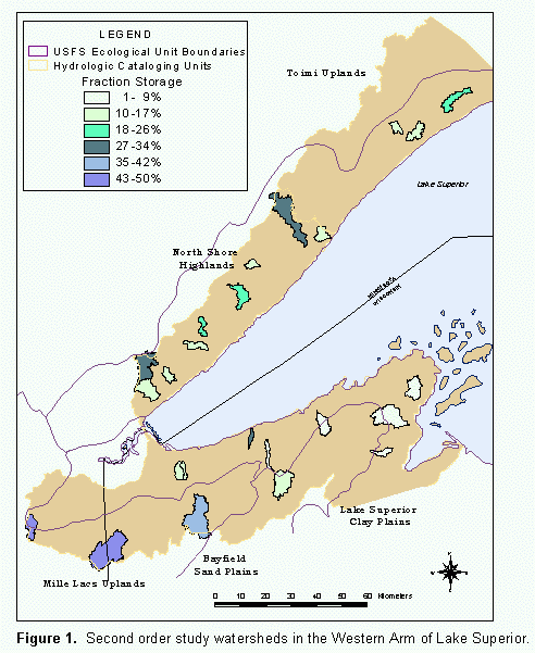
The watersheds in the North Shore of the Western Arm of Lake Superior are primarily in the North Shore Highlands ecoregion (Omernik, 1986), typified by low mountains, with an elevation range of 600-2015 feet (Figure 1). Soils are thin sandy-clayey stony till, underlain by Pre-Cambrian basalt, igneous, anorthosire, and sedimentary rock. Potential vegetation includes sugar maple-birch forests, white and red pine forests, aspen-birch forests, and white spruce-balsam fir-aspen forests. Most of the rivers in this area are relatively short, have relatively small watersheds, and large elevation changes (900 to 1400 ft drop) from headwaters to mouth. Wetlands, including forested, emergent, and bog wetlands, are more common in the headwaters, less common in the steep, rocky lower reaches of the rivers. Hydrologically isolated wetlands are common in low inland locations.
The watersheds along the Shore Shore of the Western Arm of Lake Superior are primarily in the Lake Superior Clay Plain ecoregion (Omernik, 1986) located within the lake plain, with an elevation range of 678 ft (602-1280 ft). It is underlain by Pre-Cambrian sedimentary deposits; typical soils include silt-clay-sand, sandy loamy-clayey till, outwash sand-gravel, and peat-muck mixtures. Potential upland vegetation communities are similar to those of the North Shore Highlands, with the exception of sugar maple-birch communities. Most of the upland forested area now is dominated by second or subsequent growth aspen, with considerable areas of mixed hardwoods and mixed conifers. The Lake Superior Clay Plain contains a dense stream drainage network of predominantly first to second order streams, but almost no lakes (Keys et al. 1995). The South Shore streams have lower gradients than the rivers along Minnesota's North Shore. Soils are red clay near the Lake Superior shore, transitioning to loamy sand farther inland (in the vicinity of US Highway 2). Bedrock is basalt and sandstone. There is more land in agriculture in this region than along the North Shore. Forestry operations are also present. Because of the lower gradients, more wetlands (forested and emergent) are found in the lower reaches of these rivers
METHODS
National Wetlands Inventory (NWI) (Minnesota DNR, 1997) and Wisconsin Wetlands Inventory (WWI) (Wisconsin DNR, 1997) polygon and point data were used to define the wetlands for Minnesota and Wisconsin respectively. Wetlands between 1 and 3 acres in Minnesota and 2-5 acres in Wisconsin were represented as points in the inventory. For the purposes of this study the points were buffered to create 2 acre and 3.5 acre circle polygons and given special codes to indicate that they were generated from a point. Only palustrine and lacustrine wetlands were included and adjacent wetlands of the same class were combined into a single polygon. The buffered points were then added into the NWI and WWI wetland polygon coverages.
The perennial stream networks were represented by 1:24,000 State hydrography coverages (Minnesota DNR, 1999; Wisconsin DNR, 1999), using only perennial streams for the direct surface water connections, and perennial streams plus lake and wetland connectors for the indirect surface waters connections. USGS 7.5 minute National Elevation dataset (USGS, 1999) was used as the digital elevation model (DEM) to generate flowpaths for the subsurface or overflow connections. The streams were generated using a "flowaccumulation" threshold of 17 –20 cells. Watersheds were delineated using 7.5 minute topographic quadrangles and digital raster graphics.
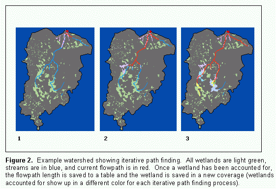
A series of routines in an AML (Arc Macro Language) script were created to find hydrologic paths from the sampling site to each wetland in the watershed. Each AML cycles through the watersheds one at a time to find the 3 classes of paths to wetlands: direct connections through perennial streams, perennial connections through other wetlands or streams, and connections through subsurface or overland flow. The paths from the sampling site to the wetlands were found iteratively (Figure 2); the nearest wetlands connected directly by surface water were found, then eliminated from the wetlands coverage and in the next run the next nearest wetlands were found (connected indirectly by surface water). Wetlands for which paths were found connecting them were then eliminated in the next run of the AML, and eventually all the wetlands connected indirectly by surface water were accounted for. In the next series of iterations, the hydrologic flowpaths were generated from the DEM to represent subsurface and overland flow to find the remaining wetlands. Each run results in a table containing watershed code, huc, length (of path to the wetland), a keyword to describe the type of the path: direct or subsurface, area (of the wetland), perimeter (of the wetland), a unique wetland ID, and the wetland system type.

Hydrologic paths were not found to all wetlands in each watershed. These wetlands were not connected by surface flow and were not on the "subsurface or overland" flow network using a "flowaccumulation" threshold of 17 - 20 cells (problems were encountered when this threshold was made smaller) OR the DEM generated flowpaths directed the flow from these wetlands out of the watershed. The "not found" wetland Ids were also saved to output files.
The general outline of the Arc Macro Language (AML) script created is shown in Figure 3. The steps corresponding to the figure are detailed below:
Each run results in a file (e.g. n2w1dist.dbf, n2g2dist.dbf ) table containing wscode2, huc, length (of path to the wetland), descr (a keyword to describe the type of the path: direct or subsurface), area (of the wetland), perimeter (of the wetland), and wetid (unique wetland ID), sys (wetland system type).
Each run also results in 3 polygon wetland coverages, one of all the wetlands "found" in that run (e.g. n2g3lks), and one representing all the wetlands "found" in that run and previous runs (e.g. n2g3all). The latter is used to eliminate these wetlands in subsequent runs. The 3rd polygon wetland coverage represents all the wetlands "not found" in each watershed after all runs are complete. These wetlands were not connected by surface flow and were not on the "subsurface or overland" flow network. The "not found" wetlands are also listed in output files (one for each watershed - e.g. 80101wetlnf.txt) and contain wscode2, huc, wetid, sys, area (of the wetland), and perimeter (of the wetland).
Each run for each set (region and order) produced a corresponding results text file (e.g. n2g3_reslts.txt). This file shows the variables' values for the AML and the results for each watershed. All output was verified visually.
The proximity-weighted wetland area was calculated by multiplying each wetland area (m2) by the inverse of the distance in meters from that wetland to the sample site. A weighted mean area of the proximity-weighted wetland areas was then used to compare with the total wetland area per watershed area (Equation 1). The weighted wetland area was calculated by taking the sum of the proximity-weighted wetland areas divided by the sum of all weights (the inverse of distance to each wetland).
Equation 1.
Proximity-weighted area equation. D is the distance from the sampling point to the wetland, 1/D is the proximity weight used. A is the wetland area.The distance for a wetland found on the sample site was set to 1, giving the highest proximity-weighted area to these wetlands. Wetlands that were "not found" by the flow network were given a distance of zero, assuming these wetlands were in a non-contributing area.
RESULTS
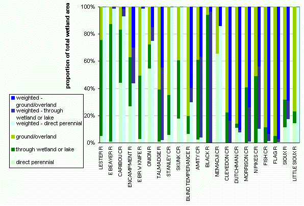
Eleven 2nd order watersheds on the North Shore of Lake Superior, and nine 2nd order watersheds on the South Shore of Lake Superior were used to test this method of finding proximity-weighted wetland area. The proportion of wetland and lake area by type of hydrologic connection compared to the proportion of wetlands calculated by the proximity-weighted area is shown in Figure 4. The proximity-weighted wetland area will always be something less than the total wetland area, because the largest weight a wetland can be given is a value of one (if the wetland is on the watershed sampling site). Figure 5 demonstrates the relative proportions of at the proximity-weighted area vs. total wetland area for the different connection types.
Figure 4.
Proportion of wetlands in watersheds by type of connection to sample site vs. proximity-weighted area of wetlands by watershed.

Figure 5.
Relative proportions of wetland area by connection type for unweighted area, and proximity-weighted area measures.
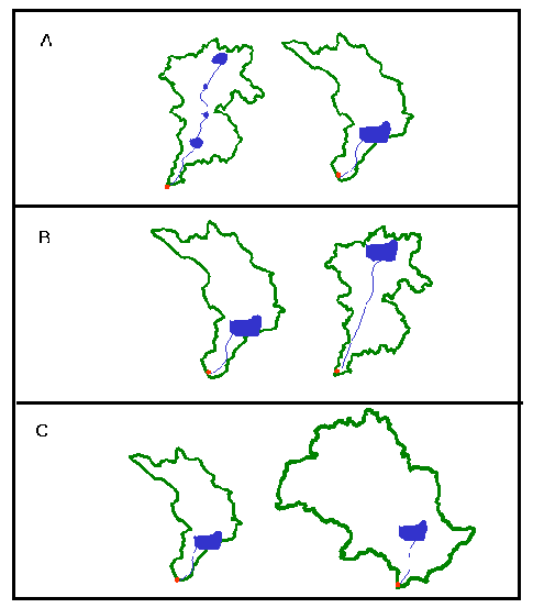
The measures of proximity-weighted wetland area provide another opportunity to elucidate the relative strength of wetland influence on water quality parameters that vary as a function of watershed storage. This measure incorporates proximity of wetlands to the sampling site. Figure 6 illustrates why wetland and watershed area may only partially explain wetland influence on water quality. Watersheds with similar storage and area may not experience the same mediating effects of the wetlands depending on their position within the watershed.

Figure 6.
Schematic of proximity-weighted wetland area for different wetland positions. A) Two watersheds of the same area and same wetland area. The total proximity-weighted area of wetlands in watershed B will be greater. B) Two watersheds of the same area and same wetland area. The total proximity-weighted area of wetlands in watershed A will be greater. C) Two watersheds of different areas, the same wetland area, and the same distance to the wetlands will have the same wetland effects relative to watershed size as the straight wetland area measure.The influence of wetlands on those water quality constituents for which wetlands are sources will diminish as the hydrologic distance between the sample site and the wetlands increases due to dilution or removal by instream processes downstream. Wetlands act as sinks for other types of water quality constituents: some water quality parameters will increase with distance due to the increasing probability that there will be sources downstream, between the wetland sink and sampling site. The proximity-weighted area value as a measure of these influences may not change after a certain distance is reached because the relative weights of the distant wetlands will be so small. It would be valuable to test whether a distance less than the entire watershed length could be used as a surrogate for the proximity-weighted wetland area calculated for the entire watershed. This distance would vary depending on the variation of size ranges of watersheds and wetlands in the sample. Calculating the proximity-weighted wetland area at a cut-off of many distances would reveal at what distance this is an appropriate assumption for these study watersheds.
Several limitations are inherent using the Geographic Information System methods and data described in this study. Best judgement was used to find a balance between standardizing methods and manipulating slightly erroneous input files. The streams coverages, the sample site coverages, and the DEMs were all created independently and therefore did not always match up. Buffer distances equal to the horizontal spatial error were used around the sample points and wetlands to search for the nearest arc that represented a stream. The spatial data were manipulated as little as possible, but in a few cases of obvious attribute miscoding or discontinuous arcs, minor corrections had to be made to the input coverages. The AML allowed for changes in the buffer and edit distances to accommodate unique situations in each watershed.
The DEMs used at 30 meter resolution allowed for horizontal errors of at least 20 meters in the representation of the overland and subsurface flow path. It was assumed that the subsurface flow would follow the surface topography. It is not known to what degree this is a good assumption in the study area. In flat areas, the DEM generated flow-paths were especially ill-defined, and probably did not adequately represent groundwater flow. The large wetlands that were "not-found" (not intersected by a flow network of any kind) were probably wetlands in flat areas of non-contributing area, however because the groundwater flow network generated does not incorporate every cell it will erroneously miss some small wetlands. In addition, there may be additional groundwater inputs to the watersheds and watershed flow networks that are not represented, because the actual groundwater flow may not be reflected in the surface topography or may come from outside the watershed.
CONCLUSION
The measures of distance to wetlands from a water quality sampling site, along with the area of those wetlands may contribute to an explanation of varying water quality between watersheds. A script utilizing Arc Macro Language for Arc/Info used an iterative process to cycle through the watersheds and through the path types, subtracting out wetlands from the original wetland coverage once a path had been "found" to it. The different connection types and the distance to wetlands in the watershed can be used in future analyses to describe endpoints such as total suspended solids and turbidity, inorganic (soluble reactive) and total dissolved P, dissolved and particulate N, ammonium, inorganic and total N:P, dissolved and total organic carbon, color, conductivity, and several major ions. Wetland area and position in a watershed determines a watershed's capacity to store and filter water, directly influencing hydrologic regime and therefore instream processes and biotic communities. A quantitative measure of wetland position in the watershed will be valuable to understanding their influence in this regard.
REFERENCES
Detenbeck, N.E., C.A. Johnston and G.J. Niemi. 1993. Wetland effects on lake water quality in the Minneapolis/St. Paul metropolitan area. Landscape Ecol. 8(1):39-61.
Detenbeck, N.E., et al. 2001. Unpublished data.
Johnston, C.A., N.E. Detenbeck, and G.J. Niemi. 1990. The cumulative effect of wetlands on stream water quality and quantity: A landscape approach. Biogeochemistry 10:105-141.
Keys, J. E., Jr., C. A. Carpenter, S. L. Hooks, F. G. Kownig, W. H. McNab, R. E. Russell, and M. L. Smith. 1995. Ecological Units of the Eastern United States: First Approximation. USDA Forest Service.
Minnesota Department of Natural Resources (DNR), 1999. DNR 24K Streams. St. Paul, MN.
http://deli.dnr.state.mn.us/Minnesota Department of Natural Resources (DNR), 1997. National Wetlands Inventory Points. St. Paul, MN. http://deli.dnr.state.mn.us/
Minnesota Department of Natural Resources (DNR), 1997. National Wetlands Inventory Polygons. St. Paul, MN. http://deli.dnr.state.mn.us/
Omernik, J.M. 1976. The influence of land use on stream nutrient levels. EPA-600/3-76-014. U.S. EPA, Washington, D.C.
Omernik, J. M. and A.L. Gallant. 1986. Ecoregions of the upper Midwest states. U.S. Environmental Protection Agency. Environmental Research Laboratory, Corvallis, OR. EPA/600/3-88/037.
Osborne, L.L. and M.J. Wiley. 1988. Empirical relationships between land use/cover and stream water quality in an agricultural watershed. J. Env. Manage. 26:9-27.
Wisconsin Department of Natural Resources (DNR), Bureau of Fisheries Management and Habitat Protection, 1997. Digital Wisconsin Wetland Inventory. Madison, WI. http://www.dnr.state.wi.us/org/at/et/geo/datasharing/custodia/wwi_1.htm
Wisconsin Department of Natural Resources (DNR), Geographic Services Section, 1999. 1:24,000 Preliminary Hydrography layer, second release. Madison, WI. http://www.dnr.state.wi.us/org/at/et/geo/data/hyd24k.html
U.S. Geological Survey (USGS), EROS Data Center, 1999. National Elevation Dataset. 1st edition. Raster digital data. Sioux Falls, SD. http://edcnts12.cr.usgs.gov/ned/ned.html
AUTHOR INFORMATION
Stacey L. Stark
Naomi E. Detenbeck
Branch Chief, Watershed Diagnostics Research Branch
US EPA Mid-Continent Ecology Division
6201 Congdon Blvd. Duluth, MN 55804
(218)-529-5204
Sharon L. Batterman
Research Aquatic Biologist
US EPA Mid-Continent Ecology Division
6201 Congdon Blvd, Duluth, MN 55804
(218) 529-5220