Bet you didn't think you could Route Trucks LIKE THIS!
Kevin Switala
Abstract
This paper describes how GIS and raster modeling can be utilized in an accessible way to dramatically change the way large planning projects incorporate public participation. Four towns in Delaware had truck routing initiatives and GeoDecisions, the GIS division of Gannett Fleming, developed an interactive spatial model that allowed participants at public meetings to weight influencing factors. The participants could then use this composite cost surface to iteratively evaluate potential alternatives. This process represents a fundamental shift away from top-down planning to a more democratic, consensus-building planning process model, while elevating participant knowledge about the issues facing such projects.
Introduction
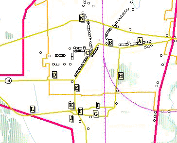
With increased development pressure, as well as the growth of trucking as a means to efficiently transport goods and materials within the state of Delaware, the Delaware Department of Transportation hired Gannett Fleming Engineers and Planners to develop a set of potential truck routing alternatives to 3 towns experiencing the greatest difficulty. GeoDecisions, the GIS division of Gannett Fleming, chose to develop a new method of creating and evaluating an alternative route through the use of interactive raster analysis model for one of the study areas, town of Harrington. The need for a truck route for the Town of Harrington was realized by the town as early as 1974 but the project did not progress to any formal study. As the result of additional town growth, including commercial development, the town reinitiated the desire for a truck route again in 1993. In 1999, the Department decided to include the Harrington truck study as part of its Corridor Capacity Preservation Project and planning efforts were coordinated at that point part of this study. The study to identify an alternative truck route is receiving funding through the Capital Improvement Program (2001 – 2006) and was initiated by the Kent/Dover MPO.
This project involves potential roadway improvements to facilitate the circulation of truck traffic and reduce negative impacts created by current designated truck routes through and around the Town of Harrington. The proposed improvements may consist of maintaining the existing route, the upgrade of existing roads serving as the current route, the re-designation or upgrade of other roads to serve as a new route, and intersections and/or construction of a new alignment.
The primary goal of this study is to develop and evaluate transportation improvements that facilitate the movement of trucks through and/or around the town of Harrington. In addition, a goal is to minimize negative effects created by trucks on the communities and on historic structures within the designated or identified historic districts within the town.
Existing Process
Typically these large-scale transportation projects follow a standard planning process which incorporates an intensive analysis of the existing landform, land development, socio-economic data, environmental constraints and historic artifacts. Data layers developed for the town of Harrington included:
Municipal boundaries
Existing transportation network
Rail corridors
Hydrology (Rivers, streams, open water)
Wetlands
Historic Districts
Archeological Sites
Registered Historic Sites
Parcel Boundaries
Land Use
Zoning
In order to develop effective improvement alternatives, the specific transportation problems within the study area must be determined and documented. Therefore, a data collection effort was undertaken in the spring and summer of 2000. The data collection effort included: twenty-four hour (utilizing ATRs) traffic data, intersection turning movement data, field reconnaissance to develop a list of truck traffic generators, and manual field counts for segments within in each study area. Additionally, area accident statistics for the last three years were compiled. Analyses included: an accident analysis, and intersection and segment levels of service analyses, and a projected growth impact analysis on levels of service.
Each of these was collected through an exhaustive data development phase resulting in a massive data set, which was at the disposal of the design team.
A physical evaluation of the existing transportation facilities was then performed. The goal of this analysis was to identify physical deficiencies or limitations that may exist for trucks traveling through the town. This analysis included evaluating roadway cross-sections, intersections and other related traffic circulation issues, such as the provision of on-street parking. The evaluation of roadway cross sections included determining overall cartway, travel and parking lane widths along the entire length of identified routes within the study area. In addition of the factors, such as average building setbacks were evaluated. All intersections along the identified routes were evaluated for turning movement deficiencies. This included developing intersection diagrams and measuring turning radii for each movement. The likelihood of conflicts between truck traffic and automobile traffic at intersections was evaluated based on field inspections. In addition, other potential conflicts between truck and automobile traffic were evaluated, such as in areas where on street parking is provided.
The next step of the process was for the planning team worked with the client to generate multiple plausible, and less-plausible, truck routing alternatives, given the physical constraints of the study area. This process generated over 15 individual segments that could be utilized as potential routes. This complexity of alternatives greatly reduced the ability of the team generating these alternatives to weigh evaluation criteria in an impartial way.
A set of public meetings was then held in the town to educate the residents on the issues involved in the trucking study, demonstrate the 15+ potential solutions, and gather input from the residents on the potential impacts each alternatives might have. However, the information and vast knowledge gained from these meetings was never utilized to its fullest potential. It appeared that the deep residential knowledge base could never really be used with the existing planning model because there was no mechanism in place to feed this information into the evaluation and selection process of the chosen alternative. It was during this phase, the public meeting phase, that the GeoDecisions GIS team member supporting the project began to develop an alternative method of evaluating and choosing a potential truck route utilizing advanced raster analysis software at his disposal.
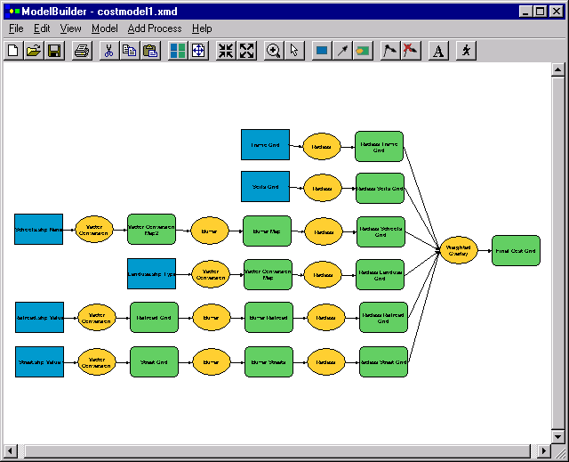
ArcView Spatial Analyst and Model Builder
With the creation of the Spatial Analyst (SA) extension to ArcView GIS 3.x the ability of the average GIS user with a minimum of raster modeling experience to analyze data in more flexible and sophisticated ways became possible. The author had significant raster modeling experience from previous jobs and was excited to be able to apply a theoretical concept to a real-life opportunity as complex as truck routing. The Spatial Analyst extension represented a robust desktop tool that could be utilized for just such a complex analysis of disparate data elements. Also, with the shipping of Model Builder with SA 2.0, the developer could now quickly automate a complex sequence of steps from data conversion, to data normalizing and to data analysis. The author had previous experience with the time-consuming process of writing lengthy Avenue scripts to automate even a small set of consecutive tasks.
Proposed Strategy
The proposed strategy consisted of a 7-step process:
1. Determine criteria
2. Collect and convert data
3. Determine weight of criteria
4. Generate cost surface
5. Evaluate/Score potential alternative
6. Iterate through steps 3-5
7. Compare resulting alternative scores
Determining the criteria to evaluate all potential alternatives remained the first step in the process. This would collect as much data as possible on the following data layers to be developed:
Existing road infrastructure
Road segment travel length
Rail crossings
Potential route turning locations
Truck generators
Fire stations
Schools
Parking lots
Historic district boundaries
Historic/Archeological sites
Parcel boundaries
Zoning
Land use
Wetlands
Hydrology
Soils
These data were collected and converted to a raster format through various methods. Point data elements such as schools and fire stations were spread from using the Find Distance routine. Other linear data elements such as rail crossings, parcel boundaries and road infrastructure were similarly spread from to generate raster surfaces evaluating the proximity of every grid cell from the origin feature. Polygon data layers were converted to raster surfaces based on values of the feature (eg. Zoning codes). Each data layer was then normalized on a scale from 1 to 10 based on assumptions made by the consulting planning team. Examples of these assumptions for the purposes of this routing analysis were:
Trucks should not be routed in close proximity to schools. A grid cell adjacent to the school received a value 10, while a grid cell far away from the school received a low value.
Trucks should utilize existing rail crossing as much as possible. A grid cell on an existing rail crossing received a low score (1), while a grid cell not directly on an existing rail crossing received a high score.

The next step in the process was to develop an interface for ArcView GIS using dialog designer that could assist a public participant in the process in weighting the individual criteria. The dialog would have slider bars based on a percentage (0-100%) to record their relative importance in the mind of the scorer and would sum to 100%.
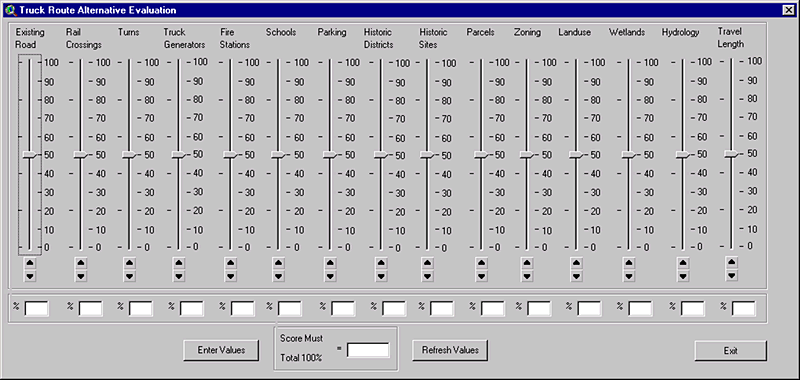
The resulting scores would be entered into the final Model Builder step to weight the combination of each criteria to generate the resulting cost, or friction, surface. This surface would have values from 1 to 100 based on the total score that each grid cell received. A high value meant that the grid cell would have a great cost if an alternative route passed over it, while a low score meant that that grid cell was conducive for use in an alternative route segment.

A public participant would then choose an alternative to judge, given the cost surface that they developed. The alternative would then be overlayed on the cost surface and the tabulation of each grid cell covered would be automated. The resulting score could then be recorded by the participant of the process.
At this stage the participant was free to change the cost surface by re-weighting a particular criteria. They could also evaluate a different alternative route for trucks on the original cost surface. This iterative process could greatly increase the general understanding of the planning process.

The final step was to compare the participants score for a particular alternative with that of a neighbor, or a business owner, or with someone from the design team, or with a representative from a trucking company. This would hopefully generate discussion on the issues that are important to many of the constituents of the project.
Conclusions
Although Model Builder and Dialog Designer for ArcView GIS 3.x greatly enhanced the author’s ability to use raster modeling in a real project, they fell short of the author’s expectations in regards to creating an efficient application. Dialog Designer works off of Avenue scripts, while Model Builder is programmed from C+. This fact was frustrating because of the inability of the dialog to directly feed the values into the model in Model Builder. The final weight values required manual entry, slowing the process down and adding unnecessary complexity to the process.
This process was, unfortunately, never implemented in real situations within the Harrington project. Time constraints prohibited its use in any of the public meetings. But, the idea and innovative strategy provided inspiration for future changes in the way the planning team conducts similar projects.
Kevin Switala
Senior GIS Analyst
GeoDecisions, the GIS Division of Gannett Fleming
1515 Market St, Suite 1530
Philadelphia, PA 19102
Phone: (215) 557-0106
Fax: (215) 557-0337
kswitala@gfnet.com