This paper documents the development of the Chicago Area Transportation Study (CATS) Geographic Information System (GIS) Intranet website - why it was necessary and how it was created. Also briefly discussed is the planned implementation of an agency-wide GIS.
GIS at CATS is a tool used by most analysts for specific projects. GIS software consists of Environmental Systems Research Institute, Inc. (Esri) products, ArcView, and ArcInfo, that operate in the UNIX and Windows NT environments. CATS GIS data is stored as coverages in the UNIX environment that can be viewed with Esri products. The coverages usually do not have associated metadata and are organized in file systems (directories) based on geography, and/or source. The system is not user friendly given its structure and the cryptic nature of the file names.
CATS GIS data rarely has metadata and, as a result, the data must be examined with ArcView or ArcInfo. Since there are a limited number of floating licenses this is not always possible and, as a result, users have to guess the coverage content based on its name, location within the file system and experience.
In order to make the GIS data more accessible and provide some rudimentary documentation Intranet pages were created that list the location and file name, source, attribute variables and their meaning, and an image that illustrates the coverage extent and content. These pages were organized and generated using ArcView, ArcInfo and Microsoft® FrontPage 98. The process is further documented within the paper. Unfortunately the pages are not widely utilized and are time consuming to maintain.
Recently, ArcIMS, an Internet map server software, was acquired which will be used to create an agency-wide GIS within the agency. The goal is to efficiently deliver GIS data to all users regardless of the platform the data is stored on or the platform the user is working on. This will be organized and implemented in a manner that compliments the existing network. More user participation is anticipated as well as the eventual elimination of the existing static GIS web pages. The plan for ArcIMS implementation is further discussed in the paper.
Transportation planning takes place at a variety of scales and GIS is an essential part of the process. The Chicago Area Transportation Study (CATS) has a significant library of base geography data and limited number of GIS software licenses available for staff use. Further complicating matters is that the computing environment has mixed operating systems, UNIX and Windows NT. The goal of this project was to make it easy to find GIS data without the need to pull a software license. Toward that end a searchable Intranet site was created to display GIS data in such a manner that users can easily find and determine if it will meet their needs. What follows is a brief description of the agency, its computing environment, how and why the site was created and the planned implementation of ArcIMS, an Intranet map server.
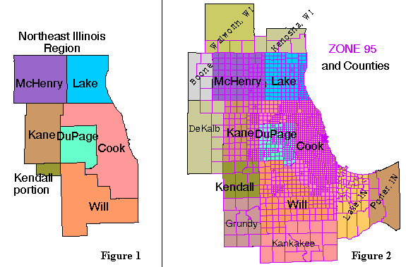
CATS is the Metropolitan Planning Organization (MPO) for Northeast Illinois which includes Cook, DuPage, Kane, Lake McHenry, Will and a portion of Kendall County, Figure 1. Long range transportation plans rely extensively on models that incorporate demographic and travel data. In order to make the plans as accurate as possible, CATS models incorporate data from the region counties plus all or part of Boone, DeKalb, Grundy, Kankakee and Kendall Counties in Illinois; Lake and Porter Counties in Indiana and Walworth, Racine and Kenosha Counties in Wisconsin, Figure 2.

CATS uses geographic data for cataloging, planning and modeling activities. For example, CATS is involved in a number of projects among those are the 2020 Regional Transportation Plan and the Transportation Improvement Program (TIP). Regardless of the project or program, all have a strong geographic component and use data that is often created and displayed at different scales. Thus CATS has a large amount of digital geographic data available for staff use.
CATS geographic information system, GIS, is comprised of digital geographic data, Environmental Systems Research Institute, Inc. (Esri) ArcView 3.1 and 3.2 (ArcView) and ArcInfo 8.0.2 (ArcInfo) software products and DigiAir, a combination of imagery and software. The digital geographic data can be divided into two categories, vector data which consists of points, lines and polygons commonly stored as coverages or shapefiles; and raster which consists of pixels of uniform size and varying values arranged in rows and columns. CATS raster data is a digital aerial product called DigiAir. The imagery is stored on the Intranet server in five resolutions, 1, 3, 10, 30 and 100 meters and is viewed using software that is installed locally on the PC. The software automatically displays the optimal resolution depending on the scale. Vector data can be imported into DigiAir or, more commonly, an image can be export from DigiAir and used in a GIS project.
CATS computing environment is set up as a local area network (LAN). Each user has a personal computer (PC) that is configured with the NT operating system. The PCs communicate with the servers of which there are several, an intranet server, an NT file server, an SUN file/software server and recently an ArcIMS server. In addition to the PCs there are six SUN workstations available. The PCs are equipped with simulation software that allows users to access the SUN server from their PCs.
In addition to the GIS data ArcInfo and ArcView software also reside on the SUN server. There are six ArcView licenses and four ArcInfo licenses available for staff use. The software can be used on the UNIX workstations, on the PC via simulation software, or in the case of ArcInfo, locally on the PC.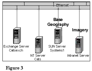
CATS GIS vector data, the base geography, is stored on the UNIX server and the imagery is stored on the Intranet server, Figure 3. Storing data on a server has two primary advantages, it allows multiple users to access the data at the same time and it is secure in the sense that the servers are backed-up on a regular basis and data can be restored in the event of a catastrophe. The data is directly accessible on the UNIX workstations and on PCs using the simulation software. The data can be transferred to a PC hard-drive and used locally.
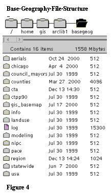
CATS base geographic data is stored on the UNIX server in Esri coverage format. The data is kept in coverages as opposed to shapefiles because coverages can contain multiple features and have topology as opposed to shapefiles, which have only one feature and are non-topological. The coverages are organized by geography and/or source, Figure 4. Most coverages don't have metadata so even though the geographic extent and feature is usually obvious from the file name or location the user still has to pull a software license to examine the attribute data and determine its usefulness to a project, Figure 5.
 |
|
One significant reason for developing web pages was the static nature of the file system, which could not be changed because GIS projects save only the reference to the data location and not the actual data. Thus the Intranet pages were used to describe and arrange information about the data.
One reason for creating web pages was to make the GIS data easier to find and use without disrupting the existing storage system. The CATS Intranet is available to all users via their web browser and web pages. Essentially the GIS web pages contain enough information about the data that its worth to a particular project can be easily determined. An added benefit is that it acts as a central repository of information about GIS data particularly since the data is stored in different environments, i.e., imagery on the NT server, coverages on the SUN
The CATS Intranet resides on an NT server running Microsoft® Internet Information Server software version 4.0. The pages were developed using a variety of software products, ArcView 3.1 to create a map that displayed the extent and feature type, Corel Photo-Paint 8.232 to convert that image to an Intranet friendly format and color scheme and Microsoft® FrontPage 98 (FrontPage) to create and manage the pages. The specifics of the process can be found in Appendix A.
 One
advantage of the web pages was that their organization did not have to strictly
adhere to the existing file systems. Although GIS base geography web pages
were initially organized according to the SUN file structure subsequent web
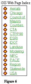
pages were not necessarily located in the same manner (Figure 6). For instance,
several datasets were received from Illinois Department of Transportation
(IDOT). While the data was in sets by county and stored within each county
directory on the SUN server the web pages were organized according to source,
IDOT.
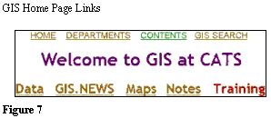
The CATS Intranet was developed using Microsoft® Front Page 98 (FrontPage). However, because there are a significant number of GIS pages at a variety of levels, the decision was made to use frames rather than the FrontPage navigation scheme. The first page is a general introduction and has five GIS specific links, Data, News, Maps, Notes and Training, in addition to the required CATS Intranet links, Home, Departments and Contents (Figure 7). The GIS base geographic data is largely described within the Data pages and final map product information is found in the Map pages. Thus this discussion is limited to these two areas.
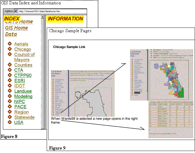
The pages are organized in a fairly straightforward manner. Following the Data link from the GIS home page opens a frame page. A frame is a page that contains two or more pages, in this case two pages, an index page on the left and an information page on the right (Figure 8). As different links are followed both pages change until the final index is reached. At that point the links in the index open pages in the window on the right as illustrated in Figure 9.
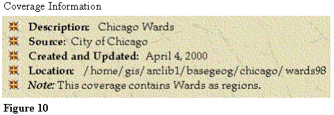
Pages have been created for most of the base geography at CATS. Notably the information included for each is very minimal - a title, source, created/updated, notes, and most importantly, location on the server, Figure 10.
| In addition to the descriptive information, a map
displaying the extent and the feature (s) is also included and a table
that describes the structure of the feature attribute data table (Figure
11). On those rare occasions when a data dictionary or other information
is available it is also included.
The pages are labor intensive to create. An attempt to automate the process using active server pages (ASP) was unsuccessful. The database used was Microsoft® Access 97 and serving images from it was unsuccessful. Further, had ASP been successful it would have made the pages more uniform however, the time consuming aspects of page creation, gathering information, creating the image and table attributes, still remained.
|
|
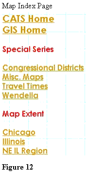
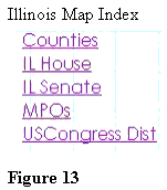
Maps from completed projects are also included in the GIS web pages. They are divided into two categories, Special Series and Map Extent, Figure 12. Special Series maps include maps from completed projects and are submitted by CATS staff to the library. Maps listed in the Map Extent portion are listed according to extent and then by topic. (Figure 13).
 |
 |
There are some small differences between the map pages and the data pages. A map page has a legend instead of an feature attribute table description. The map page information includes the size of the map and is generally more accurate since much of it comes from the map itself.
CATS recently acquired ArcIMS in order to put GIS on every desktop. An added benefit is that it will eventually make the labor intense GIS pages obsolete. It is expected to attract more users than the existing pages because it is easy to use, more interactive and is more map like. It will allow easier data browsing of base geography but it will not assist users in assessing the usefulness of the attribute information until metadata is completed. The only anticipated downside to ArcIMS is that projects created in other GIS software cannot be imported directly into ArcIMS and vice versa so that existing projects will take some time to incorporate into ArcIMS. The initial ArcIMS projects at CATS will be the Office Floor Plan as a means of teaching users about the software and its functionality followed by a TIP (Transportation Improvement Projects) application, an RTP (Regional Transportation Plan) application and a base geography/data exploration application.
The purpose of creating the web pages was to make finding GIS data easier without using a software license and the pages, combined with the web search features does this. Unfortunately these pages are not as popular as expected and this could be due to different factors. For instance, a user may prefer to call or email someone because that is their habit or perhaps the metadata is so limited that it is preferable to look at the data in a view to get an idea of what it is and the distribution. Regardless of the cause the pages are not being used to any great extent except by the GIS analyst who sends links in response to in-house requests for information about GIS data.
One result of this experience has been the resolution to write and maintain metadata beginning with Census 2000. The process has become infinitely easier for a combination of reasons, the incorporation of metadata documentation capacity in ArcGIS 8.1 and the fact that so much metadata is readily available. For example the Census 2000 Tiger data has a standard text metadata file that can be modified to suit CATS by merely changing a few aspects of it such as contact information and processing steps.
The ArcIMS implementation will put GIS on every desktop in a familiar browser environment.. It is hoped that its ease of use and interactive nature will make it more appealing to users. Since geography, like politics, is local in nature the first IMS project is the office floor plan. It will be in an HTML viewer and the map service will have layers for desks, hardware and people. The attribute tables for the staff will display the person's name, title and department with links to their home page. The tools used will be those that most resemble ArcView 3.x tools. As before, there will be an agency meeting to introduce and demonstrate this project - its anticipated launch is October, 2001.
To make a CATS GIS web page
If it is a coverage
Managing the Site
This script resizes the view window to 446 x 447 pixels - it can be attached to a button in the view window for greater
convenience.
theProject = Av.GetProject
theView = av.GetActiveDoc
theViewWin=theView.GetWin
theViewWin.Resize(446,467)
msgbox.report(theViewWin.ReturnExtent.AsString+nl+nl, "Extent")
This script creates a report on the attribute table structure - this script is available from ArcView Help, Sample Scripts.
'Reports on a table's structure'
atbl=av.getactivedoc
if(atbl.is(table).not) then msgbox.error("A table document must be active.","Error")
exit
end
theVTab1 = atbl.getvtab
theBitMap1 = theVTab1.GetSelection
fList = theVTab1.GetFields
atab=tab+tab+tab+tab
totalchar = "Alias"+atab+"Type"+atab+"Width"+atab+"Decimal"
totalchar=totalchar+nl+"---------------------------------------------------------------------"
longname=0
for each afld in flist
name=afld.getalias
if (aname.count > longname) then
longname=aname.count
end
end
for each subitem in flist
aspace=" "
itList = subitem.gettype
itPrecision=subitem.getPrecision
itwidth=subitem.getwidth
aname=subitem.getalias
compilation=aname+","+atab+itlist.asString+","+atab+itWidth.asString+","
+atab+itPrecision.asString
totalchar=totalchar +nl+ compilation
end
MsgBox.report(totalchar, "Items from "+atbl.getname.asstring)