Managing Enterprise Land Assets through a Unified GIS
Author: Michael F. Tepera
Co-Author: Todd Buehlman
In Cooperation with the PLAT team at Burlington Resources.
Abstract
Burlington Resources, a large Energy Company desired a means of managing their diverse land information through a common desktop GIS environment. Idea Integration designed and built an enterprise GIS solution that facilitates the capture, storage, display and analysis of the land-related data. The Petroleum Land Analysis Tool (PLAT) is a custom extension to ArcView whose objective was to integrate multiple enterprise land information databases through a unified desktop GIS, allowing the effective management, query, analysis, and mapping of this spatial and textual land data. The interface provides point-and-click query in plain English, hiding end-users from the database complexities and providing powerful land analysis functions that were previously difficult to achieve. Business language, database information, and data sources are integrated with the use of XML-defined metadata definition layers. Connecting multiple databases through middle-ware metadata enables the power of multiple enterprise databases to be accessed through a unified desktop GIS, resulting in more effective management of the enterprise land assets.
Business Problems and Objective
Burlington Resources is an Oil & Gas Exploration and Production company with hundreds of thousands of acres of lease holdings covering several states. Divisional offices are located throughout several states each with their own land departments responsible for managing the company's lease holdings.
The company has petroleum and land data spread out among several distributed databases to serve the regional office business applications. This distributed system prevented consolidation of the business data, making it difficult to fully exploit its value. Multiple systems were used in the query and analysis of the overall leasehold position and in addition, map production was time-consuming and inefficient. The company was seeking the development and delivery of a system to integrate their enterprise land information into a unified desktop GIS environment to allow the effective management, query, analysis, reporting, and mapping of their leasehold assets.
Solution
The system was constructed as an extension to Esri's ArcView 3.2. At the time of project initiation, consideration was given to new Esri technology (ArcGIS) and web-solutions; however, a desktop ArcView solution was preferred in order to facilitate rapid design and deployment. The solution was to be designed in a modular manner to allow a managed migration to new technology in the future.
The implementation of an open database access connection method integrated proprietary external databases into ArcView through a custom defined meta-data layer. Browsing, querying, analyzing, and mapping of this data are centralized through customized dialogs and controls, designed to provide intuitive access to the business data. The system provides access to Esri shapefiles, Esri SDE layers (including CAD layers) and tables from any ODBC compliant database. The details of the core components are as follows:
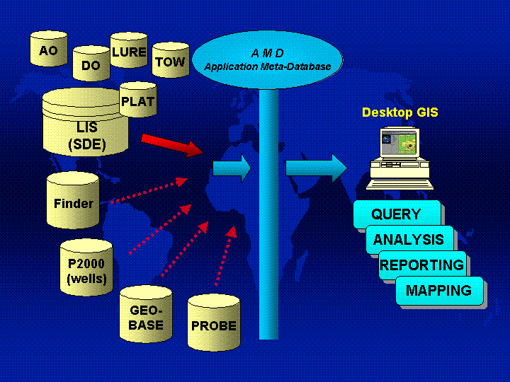
Application Meta-database (AMD) The AMD facilitates access to multiple enterprise databases (Figure 1) and defines what functionality is available to the users, and the appropriate business logic. For example, it identifies what business criteria the user can query or analyze within or across different business objects. Leases, wells and payment information are all "business objects" defined by the AMD. The AMD defines the data source (database) in which an object is stored and what the relevant attributes are associated with this business object, which may be retrieved from multiple databases. In addition, the AMD defines properties about the system initialization state. Examples include what map layers are to be viewed upon startup and how those layers should be symbolized.
Figure 1: The AMD synchronizes PLAT with business logic from external databases.
The AMD is loaded into ArcView on startup and is held in memory throughout the ArcView PLAT session in order to facilitate rapid access to the business object properties. Every PLAT request is sent to the AMD, where the AMD interprets and translates the request before handing it off to Fetcher; a customized routine that retrieves the spatial and attribute information. The current AMD is an XML formatted file, so the users can configure the business logic by updating the AMD in a user-friendly XML Editor (Figure 2). No changes to the source code are necessary to update the data source, data definition or business logic.
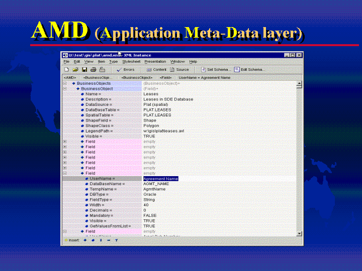
Figure 2: The AMD can be managed using any off-the-shelf XML Editor. Shown here, XML Instance 2.0.
Fetcher is PLAT's custom "query-engine". Fetcher returns each spatial query on an SDE-based layer as a shapefile "snapshot". Fetcher uses the SDE C-API to retrieve spatial geometry and attributes from databases and converts them to shapefiles and/or ArcView tables on-the-fly. Fetcher was custom-built for Burlington Resources to enhance the performance and functionality of retrieving SDE data from databases such as the "DataMart".
DataMart is an intermediate Oracle database that holds much of the data used by PLAT. It contains Oracle tables and SDE layers that are the source for most of the business objects. The attributes of the business objects are pulled from these external databases and combines spatial and attribute data into one logical database (Figure 3). This database is updated on a regular basis, extracting updates from other Burlington databases, ensuring that DataMart tables are kept up to date. DataMart serves as the main data source for PLAT business objects.
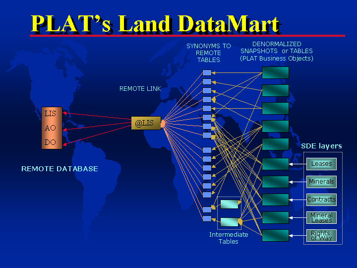
Figure 3: PLAT was designed to pull from multiple external databases using a highly customized DataMart.
System Functionality
The system provides five major functions:
Area of Interest: A user can spatially define a study area by creating an Area of Interest (AOI). A saved AOI is recorded by the system so the user can navigate quickly to a geographic region. AOI's preserve place-name, projection, coordinate system, scale, and user information (Figure 4). Users generate collections of AOI's and can use them to spatially filter query and analysis functions. AOI's can also be saved to a floppy disk or network drive for sharing. Currently, PLAT offers a custom interface for a variety of creation methods such as;
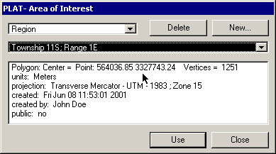
Figure 4: Area of Interest Dialog. Any saved AOI can be applied to a PLAT query to spatially limit the query results.
Query:
Leases with payments due, expiring leases, and well depths are examples of the type of custom queries that can be executed. PLAT provides an interface that allows users to create simple and complex queries without having to know underlying database details (Figure 5).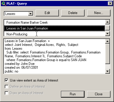
Figure 5: Query Interface: Users choose from a list of saved queries. A query is run and the results are automatically added to a view with appropriate legend properties.
PLAT presents business logic as plain English through a custom query interface, and translates a user-defined query into database specific query language such as Structured Query Language (SQL) or native ArcView syntax (Figure 6). In addition, an Area of Interest can be applied to any query to restrict the results to a specific geographic region. Once a query is created, it can be saved and run at any time during a PLAT session. Similar to saved AOI's, queries can also be shared between PLAT users. Complex queries that require multiple table joins or access to Oracle views are performed on the fly without the user's knowledge, resulting in a powerful query tool that is easy to use.
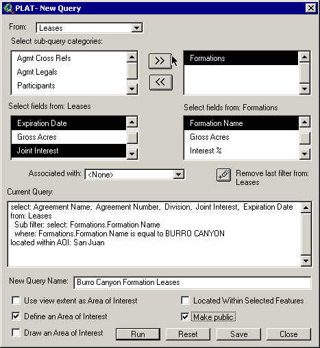
Figure 6: Query Interface: A user designs custom queries through an interface that hides them from the database complexities.
Analysis:
Several analytical functions have been implemented in PLAT, including: Drilling Unit Analysis and Stacked Polygon Analysis. Analytical functions are managed the same way a query is managed. The user has a custom interface to design an analysis, and the interface supplies database values (i.e. formation groups and formations) that assist the analysis creation (Figure 7). The analysis is saved and can be executed at any time. An AOI can be applied to filter the output to include only the results of a specific area. Like saved AOI's and queries, PLAT analysis functions can be written to disk and shared between PLAT users. Output from running analyses is automatically added to an ArcView session as a shapefile and associated tables, and a report is written to either a spreadsheet or web browser in formatted HTML.
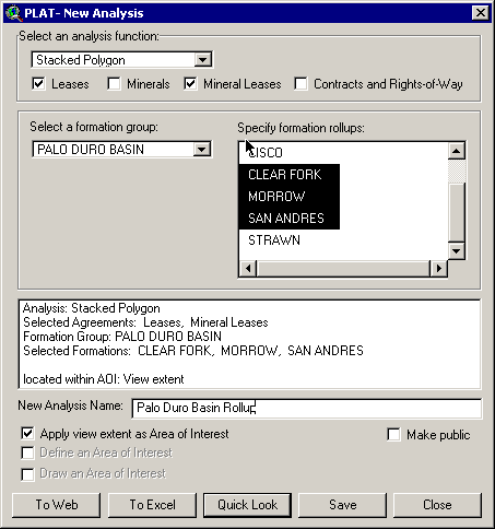
Figure 7: Analysis Interface: A user constructs analysis functions, or "Rollups". A report is generated and can be viewed in a spreadsheet or web browser.
Drilling Unit Analysis allows the user to define an area of interest (presumably, drilling unit), finds all leases (or mineral leases, or fee simple, respectively) that have Burlington interest in the formation in question, and computes the area of overlap between each lease and the area of interest. The components of gross working interest and net revenue interest for each product type are then retrieved for each lease and summed up for the entire area of interest in proportion to the overlap area.
Stacked Polygon Analysis checks all lease, mineral lease, and fee simple polygons within a user-defined area for possible overlap. The company acreages, working interests and revenue interests are then summed up within each group and represent the total company interest in a particular formation for a certain piece of land. It may be possible for several leases to overlap, contributing to the total interest.
Imagery Management: The use of imagery can greatly enhance the interpretation, analysis and presentation of an area. An image manager was designed to facilitate the browsing and retrieval of appropriate imagery over the viewing area (Figure 8). Examples of imagery include; color infrared digital orthophoto quarter quads (DOQQS) in Mr. SID file format, scanned USGS topo quad digital raster graphics (DRGs), false color LANDSAT TM tiles, and more.
Figure 8: The Imagery Manager dynamically verifies that image sets are spatially coincident with the current view extents. Projection differences are resolved by altering the view to match the image set's coordinate system.
The imagery sets vary in size; some sets have only a few individual tiles, others have thousands. The PLAT Imagery Manager hides the end-user from this information and provides automatic meta-data information about the image properties; the user has easy access to the date the imagery was collected, resolution data, and imagery type. In addition, the manager dynamically verifies that an image set is coincident with the current map view coordinates. Map projection issues are managed on the fly, automatically adjusting the view to match the selected imagery's coordinate system.
Data Exchange: The system provides a custom interface for exporting any spatial theme to a Z-Map compatible file. This provides a simple method of transferring culture data from a GIS environment to a 3D environment.
Automated Mapping: Users can increase productivity by spending less time creating maps. This is accomplished by using custom-defined mapping templates stored in ArcView object database files. The user who wants a hardcopy map of the current view can select a custom template through the mapping interface (figure 9) and the pre-defined templates provided automated scaling, legend, watermark, user information, and automated index mapping added to the map layout.
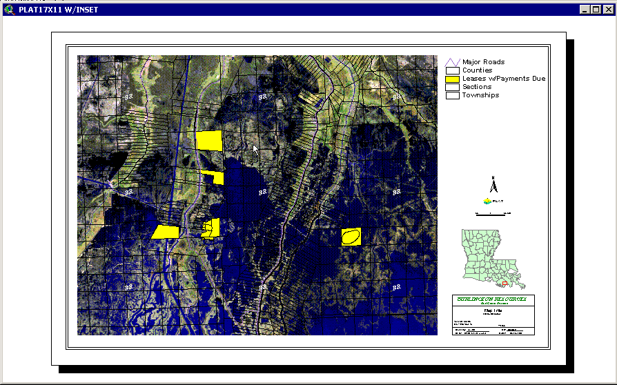
Figure 9: An example of an auto-generated map. The map is immediately ready for plotting.
Summary
The Petroleum Land Analysis Tool (PLAT) is an IT-based GIS solution designed to provide a solution for accessing multiple enterprise databases through a unified desktop GIS. The solution was developed as a modular extension to the Esri ArcView desktop GIS product utilizing an Open Data Access connection method to a variety of enterprise data sources, such as shapefiles, coverages, SDE layers, and any ODBC compliant database. This was achieved by implementing a connection method utilizing an Application Meta-data Layer (AMD) that describes the appropriate business data (leases, wells, and culture, etc.), with business logic, from multiple databases. The ability to combine business logic with multiple spatial and attribute data sources provides a powerful enterprise tool for the effective management of land assets through a unified desktop GIS.
Acknowledgments
The authors would like to thank the knowledagble Burlington Resources staff for their commitment to the project and valuable input. In addition, this project could not have been successful without the dedicated leadership of our Solutions Manager, Andrew Conacher and our Project Manager, John Martinez. We would also like to thank Ivan Gatchik for his countless hours of work on Fetcher and Barbara Skelly for her understanding of complex database issues.
Michael Tepera
GIS Consultant
Idea Integration
Phone: 800-685-5562
Fax: 713-626-2792
Todd Buehlman
GIS Consultant
Idea Integration
Phone: 800-685-5562
Fax: 713-626-2792