A Method for Understanding the Hydrologic Implication of Comprehensive Land
Use Plans
Renee Gunn, Jane Frankenberger, Bernie Engel
Agricultural and Biological Engineering Department,
Purdue University
Introduction
The population of Indiana has increased 9.7% since 1990, with many Indiana
families moving into subdivisions built on past agricultural lands. This increased
development and resulting land use changes have a significant impact on both
water quality and water quantity. As communities grow, local officials generally
concentrate on the economic implications of growth (i.e., tax base, number of
jobs, new housing starts, etc.) and pay little attention to the water resource
implications of this growth. Land use plans (and resulting planning and zoning
activities) must consider the impacts of potential land use changes on water
resources if water quality goals are to be achieved. However, there are few
models for how this can be done.
Two simple indicators of water resource impacts resulting from development
are runoff depths determined by the NRCS Curve Number Method (USDA, 1986) and
percent impervious surface. The NRCS Curve Number Method was developed as a
simple, easy to use method to determine runoff from an area based on rainfall,
land use and hydrologic soil group. The basis of the method is the Curve Number,
which is determined by the land use and the hydrologic soil group. The low data
requirements and the ease of use has made the Curve Number Method a very popular
method, and it is used in many more complex models. The L-THIA (Long-Term Hydrologic
Impact Assessment, http://www.ecn.purdue.edu/runoff)
model, which is based on the NRCS Curve Number Method, was used in this analysis
to determine runoff depths. The percent impervious surface of a watershed has
been shown to have a direct effect of the quality of the water and streams in
the watershed (Scheuler, 1994). Impervious surfaces are any area in which water
cannot infiltrate into the ground such as rooftops, roads, parking lots and
sidewalks. The majority of impervious surfaces are in the form of roads and
parking lots.
One objective of this study was to analyze the hydrologic implications of three
land use scenarios in Howard County, Indiana; 1) the current land uses (Current
Land Use) 2) a full build-out based on the current comprehensive land use plan
('Worst Case Build-out) 3) a full build-out based on a proposed land use plan
(Proposed Planned Growth). A secondary objective was to document the process
used in this study so that others may conduct their own analysis with a comparable
approach.
Study Area
The unincorporated area of Howard County, Indiana was chosen for this example
analysis based on three factors; the large rate of growth around a metropolitan
area, the similarity of Howard County to other Indiana counties and the availability
of data. The areas immediately outside the city limits of Kokomo, the major
metropolitan area in Howard County, are experiencing a high rate of development,
mainly residential. This type of growth, residential and small amounts of commercial
outside the city limits, is not limited to the large cities in Indiana, but
also many small to medium size communities. The current zoning in many of these
counties either does not restrict the subdivision of land, or the land is being
rezoned at a rapid rate.
In 1997, Howard County Plan Commission, which has jurisdiction in the unincorporated
area of the county, saw the need for a new comprehensive land use plan for the
county and hired a consulting firm to create a new comprehensive plan with the
input from the community. Comprehensive plans usually contain information on
where the county is, where they want to go, what it will look like and how to
get there. The important information for this project in the Proposed Howard
County Comprehensive Plan includes current zoning maps and explanation of the
zones, current and expected future sewer districts, and the Proposed Planned
Growth zoning maps.
To better understand the effects of the comprehensive plan on the water resources
of Howard County an analysis of possible future changes in land use and their
long-term effect of the hydrology was conducted using L-THIA. The Current Land Use was used as a base line to compare the impact of water resources of future
land uses. The 'Worst Case Build-Out' is based on the maximum amount of development
allowed under the current zoning. A full build out of the proposed land use
plan is the basis of the Proposed Planned Growth analysis.
Methods
Data Sets
|
The first step in the analysis was the organization of the data. Soils
data for the county and three sets of land use or zoning data were used
in this project: Current Land Use, current zoning and Proposed Planned Growth zoning.
Current Land Use
The Current Land Use (Figure 1.) is based on GAP land use data. (ISURSL,
http://baby.indstate.edu/geo/rs/
) . This data, derived from satellite imaging, was originally created
to determine natural cover types for vertebrates to help define 'gaps'
in the habitat. In order to simplify this analysis, many of the non-urban categories were combined in order to reduce the original 18 classifications of land use to 6. The categories used
in this project are explained in Table 1.
|
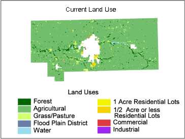 |
| Figure 1. Current Land Use of Unincorporated Howard County,
Indiana |
Table 1. Current Land Use Categories
| Land Use Category |
Explanation |
| Agricultural |
Row Crops: Corn, Soybeans and other crops, unplanted/bare
agricultural fields at time of imagery, row crops with standing water during
at least 1 image date |
| Forest |
Terrestrial and Palustrine Wetland: Evergreen Forest, Mixed
Evergreen/Deciduous Forest, Deciduous Forest, Deciduous Woodland, Deciduous
Woodland |
| Grass/Pasture |
Agricultural Pasture and Grassland |
| High Density Urban |
Urban: High Density: Industrial, Commercial, Mixed urban/built-up |
| Low Density Urban |
Urban: Low Density: Residential, Mixed urban/built-up |
| Water |
Water Bodies |
Current Zoning
Paper maps of the current zoning were available from the Proposed Howard
County Comprehensive Plan (Bernardin et al., 1998). The maps were scanned
and imported into ArcView. The ArcView Image Analysis extension was used
to rectify the scanned image to its correct geographic location using
an available 'roads' layer as a reference. The images were stretched and
moved until the roads on the image lined up with the roads layer. The
zoning classes were then screen digitized using functionality within ArcView.
|
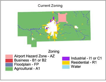 |
| Figure 2. Current Zoning of Unincorporated
Howard County, Indiana |
| Table 2. Zoning Districts
for Howard County |
Howard County's current zoning includes eight zoning districts which
are summarized in Table 2, in detail in Table A.1 in the Appendix, and
shown in Figure 2. Over 80% of Howard County is zoned A1, which allows
for agriculture and single-family dwellings at an intensity of 2.18 dwelling
units per acre (du/acre). There are also numerous of non-contiguous areas
of land that have been zoned residential along the perimeter of the city
of Kokomo. There are also areas that have been zoned industrial or commercial
along the perimeter in a similar non-contiguous manner.
|
| Abbreviation |
Title |
| A1 |
Agricultural |
| R1 |
Residential |
| B1 |
Local Business |
| B2 |
General Business |
| C1 |
Light Industrial |
| I1 |
General Industrial |
| AZ |
Airport Hazard |
| FP |
Flood Plain |
|
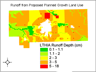
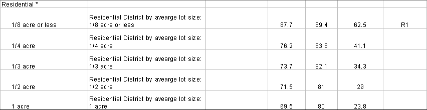
'Proposed Planned Growth'
The new Comprehensive Plan for Howard County lays out a plan for future
growth within the county. This Proposed Planned Growth Zoning (Figure
3) recognized that the majority of the residential growth would be near
the cities and towns, while farmland away from town needs some protection.
This plan allows higher density residential (1/2 to 1/4 acre lots) subdivisions
near the city, sets aside an area for 'country homes' on 1/2 to 2 acres
in an outer ring and increases the minimum lot size far away from the
cities to 2 acres to promote agriculture in the area. An expanded commercial
district was also planned on the north edge of the city. By promoting
growth near the cities, better planning can be done for services such
as roads, sewers, schools and fire stations.
|
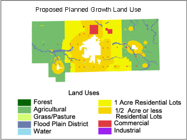 |
| Figure 3. Proposed Planned Growth of Unincorporated
Howard County, Indiana |
Hydrologic Soil Group
Another set of data needed for this project was the NRCS Hydrologic Soil
Groups. This data is complied by the NRCS as part of the soil surveys
for each county. The data used in this analysis is from the STATSGO data
set. This data is available for the entire country in digital form, but
is not as detailed as the SSURGO data that is available for several counties
in Indiana, but currently not Howard County. The hydrologic soil group
is an indication of the runoff potential of the soil. 'A' type soils,
such as sandy soil, have very low runoff potential . Heavy clay and mucky
soils are of type 'D' and have very high runoff potential. The digitized
soil map for Howard specified only B and C type soils that are the most
common in northern Indiana.
|
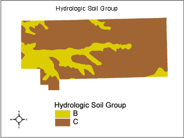 |
| Map 4. Hydrologic Soil Group of Unincorporated
Howard County, Indiana |
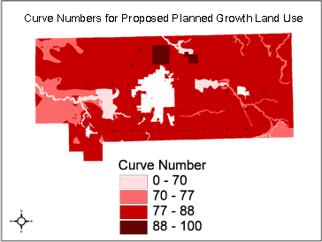
Curve Numbers and Percent Impervious Surface
The Curve Number was found for every land use and hydrologic soil group combination
in the three scenarios; Present Land Use, 'Worst Case Build-out', and Planned
Proposed Growth. Many of the land use and hydrologic soil group combination
were determined from the NRCS publication Urban Hydrology for Small Watersheds,
TR-55 (USDA, 1986) while others were determined for a specific land use not
listed. The modifications of the Curve Numbers resulted in non-whole numbers.
The listing of Curve Numbers to the tenth is for comparison of changes to the
Curve Numbers when factors such as conservation tillage or roads are included.
When Curve Numbers are used in the equations they are always whole Numbers as
directed in the USDA publication TR-55 (USDA, 1986) and are used as such in
this project.
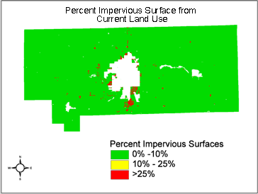
Percent impervious surface was also found for every land use used in this project. Some land uses like agricultural, forest and grassland had a very low percent impervious surface due to the scattered houses and few roads in the area. Other more urban land uses had much higher percent impervious surfaces. The percent impervious surface for residential areas was modified from the percentage listed in TR-55 to account for roadways.
Current Land Use
The majority of unincorporated Howard County is being used for agriculture. There are areas of forest mainly along the banks and in the floodplain of Wildcat and Kokomo Creeks. Most of the residential housing is on the south and west sides of the city of Kokomo with only a small amount of Industrial or Commercial on the northern side.
The Curve Number and percent impervious areas had to be determined for all
of the land use/ soil group combinations in this scenario. The Curve Numbers
for the land uses; Forest, Grass/pasture, High Density Urban and Water, were
found directly from TR-55. The High Density Urban classification from the GAP
classification indicates Commercial/Industrial and thus, the Curve Number for
Commercial was used. For agriculture and Low Density Urban, the Curve Numbers
could not be directly determined from TR-55.
The Curve Numbers representing agricultural land in Howard County were found
by using a weighted average of the various Curve Numbers for each land use based
on the acreage of each crop or tillage type (Table 3.). For agricultural areas
the Curve Number varies by crop and tillage type. The data was not available
for each field in Howard County, but the acreage of fields under different cropping
or tillage practices was.
The major crops in Howard County are corn and soybeans and to a lesser degree
wheat and hay. The average acreage over the past 10 years for each crop was
found using the NASS (National Agricultural Statistics Service) on-line database
(http://www.nass.usda.gov:81/ipedb/)
and is summarized in Table 3. Conservation tillage practices such as no-till
have long been known to reduce runoff from agricultural fields. 80% of the soybeans
and 17% of the corn in Howard County in 2000 was planted using conservation
tillage practices (Evans et al., 2000). The acreage of corn and soybeans were
adjusted to reflect the approximate amount of conservation tillage in Howard
County.
| Table 3. Agricultural Land
Uses in Howard County (NASS, 2000) |
| Crop |
Curve Number |
Total Number of Acres |
% of total |
% * Curve Number |
% Impervious Surface |
| Row Crops |
Hydrologic Condition |
B |
C |
|
|
B |
C |
|
| Corn, Straight Row |
good |
78 |
85 |
56274
|
37.49% |
29.2 |
31.9 |
0.0 |
| Corn, Conservation Tillage |
good |
75 |
82 |
11526 |
7.68% |
5.8 |
6.3 |
0.0 |
| Soybeans, Straight Row |
good |
75 |
85 |
14700 |
9.79% |
7.3 |
8.3 |
0.0 |
| Soybeans, Conservation Tillage |
good |
75 |
82 |
58800 |
39.17% |
29.4 |
32.1 |
0.0 |
| Wheat |
good |
75 |
83 |
3400 |
2.27% |
1.7 |
1.9 |
0.0 |
| Hay |
good |
58 |
71 |
2600 |
1.73% |
1.0 |
1.2 |
0.0 |
| Roads |
|
98 |
98 |
2800 |
1.87% |
1.8 |
1.8 |
98.0 |
| Total |
|
|
|
150100 |
100.00% |
76.3 |
83.5 |
0.0 |
|
The Curve Number and the percent impervious surface of the urban land uses
were based on the lot layout and the road requirement. TR-55 reports that a
1/2 acre residential lot is 25% impervious, but this does not include the roadway
required in front of the house. Based on the roadway width, right-of-way and
minimum lot width required by Howard County, the minimum amount of roadway required
for a lot was determined (See Appendix B. Calculations) First, the area needed
in front of the lot for the right-of-way and road was added to the lot area.
The road was considered 100% impervious with a Curve Number of 98, the remaining
area of the right-of-way was considered grass with a percent impervious of 0%
and a Curve Number of 61 or 74 depending on the hydrologic soil group. The total
lot Curve Number and percent impervious surface was found from computing a weighted
average, based on acreage, of the impervious surfaces and the grass (Table 5).
The minimum lot width, right-of-way and
roadway width were not given for commercial areas. Since the percent impervious surfaces were already quite high, they were assumed to not change greatly if road and right-of-ways were taken into account.
Even in land classified as agriculture or grass/pasture, there are some impervious
areas. For the rural areas, the impervious surfaces were mainly roads, which
were not separated from the agricultural areas in the GAP classification. Based
on the road survey in the Howard County Comprehensive Plan, 2800 acres, approximately
2% of the land classified as agriculture is impervious (Table 3). Aerial photos
showed that portion of the area classified as grass/pasture in the GAP data
was actually Low Density Residential or Farmstead. (Table 5)
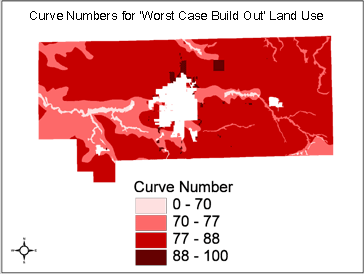
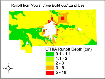
'Worst Case Build-Out'
The 'Worst Case Build-out' scenario demonstrated what could happen to land
use patterns in Howard County based on its current zoning, although it is not
considered likely. This included building houses on 1/4 acre lots and roads
to service the houses throughout the current residential areas (zoned R1), expanding
current industrial and commercial areas (zoned B1, B2, C1 or I1) to the extent
of the zoning and converting all of the area currently zoned A1 to residential
subdivisions with 1/2 acre lots and the roads needed to access these areas.
|
The area currently zoned R1 was treated the same as the low density urban
from the Current Land Use classification. There is a stipulation in the
Howard County Zoning ordinances concerning lot size based on whether the
residential area is serviced by sewers. If the area is not serviced, the
minimum lot size is 1/2 acre compared to 1/4 acre for serviced areas.
The sewer service district map in the Howard County Comprehensive Plan
was compared with the area zoned R1. There was only a small area on the
east side of town that was zoned residential and not currently in the
sewer district. Therefore it was assumed that there were no zoned residential
areas without sewers. Residential subdivisions with half acre lots were
'built' in all of the area zoned A1. Also included were the minimum acreage
of roads required for these subdivisions (See Appendix B. Calculations).
By including the roadway both the Curve Numbers and the percent impervious
surface are increased from the values listed in TR-55. The Curve Number
and percent impervious surface for this area were computed similarly to
the low density residential land use from the present land use scenario.
|
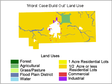 |
| Map 5. 'Worst Case Build Out' Land Use |
All of the area zoned A1 was assumed to have residential subdivisions built
upon it in accordance with the current zoning regulations. Current zoning regulations
state that permitted land uses include agriculture and single-family dwelling
at an intensity of 2.18 dwelling units per acre. As with the area zoned R1,
the required minimum roadways were included in the calculations of Curve Number
and percent impervious surfaces (Appendix B. Calculations). The Curve Number
and percent impervious surface was computed similarly to the low density residential
land use from the present land use scenario. This resulted in the addition of
about 1/4 million houses on 1/2 acre lots in the area currently zoned A1. Not
only did this add quite a few rooftops to the area it also added a large number
of roads.
The Airport Hazard Zone can only be developed into urban areas by special exception,
so this area remains agriculture. Although agriculture is allowed in the Flood
Plain District according to the zoning ordinances, some of this area is currently
forested and will most likely remain in that state. Because of this the Flood
Plain District is assumed to be 50% agriculture and 50% forest. The Curve Numbers
and percent impervious surfaces for agricultural areas and those used in calculations
for the Flood Plain District are identical to those used in the Current Land
Use scenario.
Proposed Planned Growth
The Proposed Planned Growth Zoning includes three rings of residential
housing districts with each having a range of permitted lot sizes. In
this project, the average lot size for each range was used. The area nearest
the Kokomo and the towns was designed to be Medium Density Residential
with lots ranging from 2 to 4 dwelling units per acre (1/2 to 1/4 acre
lots). The second ring of residential zoning was designated Low Density
Residential and included lots from 1/2 to 2 dwelling units per acre (2
to 1/2 acre lots). The Curve Numbers and percent impervious surfaces were
computed based on 1/3 and 1 acre lots respectively in a similar fashion
to residential areas in the Current Land Use section of the project. Since
this is a proposed plan, details such as minimum lot width were not provided.
For roadway calculations, the lots were assumed to be square.
|
Table 4. Residential Land
Uses for Proposed Planned Growth |
| Land Use |
Dwelling Units per Acre |
Lot Size |
| Medium Density Residential |
2 to 4 |
1/2 to 1/4 |
| Low Density Residential |
1/2 to 2 |
2 to 1/2
|
| Very Low Residential |
< 1/2 |
> 2 |
|
The final residential zoning included on the maps is the Very Low Density.
The large lot size is to discourage subdivision growth and to keep the land
in agricultural production or forested. For this reason, the Curve Number and
percent impervious surfaces are based on current agricultural practices, farmsteads,
a few residential houses and roads (Appendix A.2. Very Low Density Residential).
This plan does not include a different zoning classification for the flood
plain; some of this area is currently forested and will most likely remain in
that state. Because of this, the Flood Plain District has been included in this
scenario and is assumed to be 50% agriculture and 50% forest and the Curve Number
and percent impervious surface are identical to the Flood Plain District in
the 'Worst Case Build-out'. The plan also incorporated an expanded commercial
district on the north side of town that will include a new automotive plant
in the near future. The Curve Number and percent impervious surface used for
the commercial district are those found in TR-55.
Average Annual Runoff
To determine the average annual runoff using the NRCS Curve Number method,
L-THIA (Long-Term Hydrologic Impact Assessment) was used. L-THIA is a straightforward
analysis tool that provides estimates of changes in surface runoff and nonpoint
source point pollution (NPS pollution) resulting from past or proposed land
use changes. It estimates long-term average annual runoff for land use and soil
combinations, based on actual long-term climate data for that area. By using
many years of climate data in the analysis, L-THIA focuses on the average impact,
rather than an extreme year or storm.
Because the data for this project was compiled and created in terms of GIS
maps, and the GIS version of L-THIA was used. The GIS version automates the
process of impact modeling within the ArcView GIS. The model produces maps of
runoff depth and volume along with nonpoint source pollution loading of the
area. The process used in this project with the GIS version of L-THIA is relatively
straight forward and follows the steps laid out in the publication L-THIA NPS
available at the L-THIA website (http://www.ecn.purdue.edu/runoff
click on L-THIA GIS). Using custom Curve Numbers is covered in Appendix II and
used in this project. Only the runoff portion of L-THIA was used in this project,
but determining the nonpoint source pollution values is a simple next step.
Results
Curve Number and Percent Impervious Surface
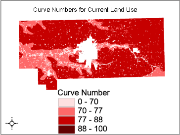
Current Land Use
Table 5. Current Land Use Curve Numbers and Percent Impervious
Surface
|
Land Use
|
Curve Number
|
% Impervious Surface |
| Hydrologic Soil Group B |
Hydrologic Soil Group C |
| Agriculture |
76.3
|
83.5
|
2
|
| Forest |
55
|
70
|
< 1
|
| Grass/Pasture |
61
|
74
|
3
|
| Low Density Urban |
76.2
|
82.8
|
41.1
|
| High Density Urban |
92
|
94
|
85
|
| Water |
0
|
0
|
0
|
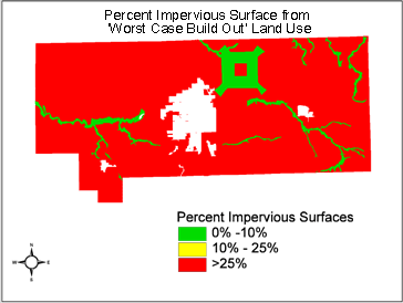
'Worst Case Build Out'
Table 6. 'Worst Case Build Out' Curve Numbers and Percent
Impervious Surface
|
Land Use
|
Curve Number
|
% Impervious Surface |
| Hydrologic Soil Group B |
Hydrologic Soil Group C |
| 1/2 acre residential lots |
71.5
|
81.0
|
29
|
| 1/4 acre residential lots |
76.2
|
82.8
|
41.1
|
| Agriculture |
76.3
|
83.5
|
2
|
| Flood Plain District (50% agriculture and 50% forest) |
76.3
|
83.8
|
1
|
| Commercial |
92
|
94
|
85
|
| Industrial |
88
|
91
|
72
|
Proposed Planned Growth Land Use
Table 7. Proposed Planned Growth Zoning Curve Number and Percent Impervious Surface
|
Land Use
|
Curve Number
|
% Impervious Surface |
| Hydrologic Soil Group B |
Hydrologic Soil Group C |
| Medium Density Residential (1/3 acre lots) |
73.7
|
82.1
|
34.3
|
| Low Density Residential (1 acre lots) |
69.5
|
80.0
|
23.8
|
| Very Low Density Residential (Mainly Agricultural) |
75.9
|
83.5
|
2
|
| Commercial |
92
|
94
|
85
|
| Flood Plain District |
76.3
|
83.8
|
1
|
 |
 |
In the Current Land use map there is a similarity between agriculture and low
density urban Curve Numbers, but a large difference in the percent impervious
surface. Even with the Curve Number for agriculture being decreased for use
of conservation tillage in the county and Curve Number for low density urban
being increased due to the inclusion of roads in the subdivision, low density
urban still has slightly lower Curve Numbers than agriculture. The effects of
tillage on compaction and the disruption of the soil profile increased the Curve
Number for agriculture. In contrast, the Curve Number for low density urban
is based on the large amount of impervious surfaces from rooftops, driveways
and roadways and the large amount of grassed lawns. The percent impervious surface
in agriculture, forest and grass/pasture are a result of houses, barns and roads
within these areas. By comparing the areas classified as agriculture, forest
and grass/pasture with the aerial photographs it was seen that there were scattered
houses and farmsteads in these areas. This was especially evident in the grass/pasture
area where a large portion of the area was actually large acre residential lots.
Although differences in Curve Numbers between 1/2 acre lots and 1/4 acre lots
is small in the 'Worst Case Build Out' land use, the resulting change in runoff
will be of greater magnitude due to the non-linearity of the Curve Number methods.
Based on the required width of the road and minimum lot width, between 6% and
9% of the new ˝ acre subdivisions will need to be roads, not including new or
upgraded major thoroughfares. These roadways, along with the rooftops, driveways,
etc. will increase the percent impervious surface for both of the residential
areas above the 25% percent impervious surface limit that Scheuler states results
in degraded streams (Schueler, 1994).
Runoff
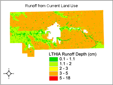
The NRCS Curve Number method was designed for "comparing the effectiveness
of alternative systems of measures within a watershed project. [It is] not used
to recreate specific features of an actual storm."(Kent, 1966) Because of this,
runoff results from different land uses are compared to each other rather then
focusing on specific values. The runoff values for the three scenarios are shown
above with values listed for a reference on the magnitude of the change.
The values for the Current Land Use scenario are mainly in the low to medium
range. Although there are very few impervious surfaces, the agricultural fields
still produce runoff. This is mainly from soil disturbance due to tillage, lack
of ground cover and compaction from farm machinery. The areas of B hydrologic
group soil have slightly less runoff than the C soils. In this county, the majority
of the B type soils occur near Wildcat Creek or other smaller creeks.
When houses and roads are added in the 'Worst Case Build-out' scenario, the
runoff remains decreases slightly. Although the percent impervious surface increases
from 2% to 29% from the addition of rooftops, driveways, and roads, there are
large areas of lawn also added. The NRCS Curve Number Method assumes that the
lawns act similarly to open grassland or pasture which has high infiltration
rates and thus lower Curve Numbers. Limited research with conflicting results
has been conducted in this field, so the assumption that lawns act similar to
grassland was used in this project.
In the Proposed Planned Growth Scenario, the ring nearest the cities and towns
had the highest runoff rates for residential areas. These rates decreased as
the number of houses per acre decreases. The very slight difference in the runoff
between the three residential zones in the Proposed Planned Growth land use
shows that the hydrologic soil group has more of an effect on the Curve Number
than the lot size in the residential areas. This suggests that when planning
for future growth both the proximity to cities and the hydrologic soil group
should be considered. In all of the scenarios, the commercial and industrial
areas have the highest amounts of runoff, mainly due to the large amount of
impervious surface on site such as parking lots and roofs.
Summary and Conclusions
By using the L-THIA model three land use scenarios, Current Land Use, 'Worst
Case Build-out' and Proposed Planned Growth were compared for the unincorporated
areas of Howard County, Indiana. The majority of work in this type of project
is the compilation and development of the data sets. The data, the steps and
assumptions used to develop the data and the analysis using L-THIA are outlined
in this paper. Development of data included classifying the Current Land Use
data into categories that L-THIA uses, making assumptions and calculation, regarding
roads, and interpreting the Proposed Planned Growth Zoning. Converting land
use into Curve Number and percent impervious surface was the final step in developing
the data. The L-THIA model was then used to compare runoff from the three scenarios.
By comparing the three scenarios it was shown that by allowing unrestricted
growth in the area currently zoned A1, the runoff would slightly decrease, but
the percent impervious area will be above 25%. By adopting the new comprehensive
plan the county can focus residential growth near Kokomo and the smaller towns,
thus persevering the agricultural land and reducing the hydrologic impact of
the growth on the county as a whole.
This paper presents a method for understanding the effects that comprehensive
plans can have on the hydrology of the county by either not being restrictive
as in the current plan for Howard County or by planning for growth as the proposed
plan does. The results of this project also include Curve Number and percent
impervious surface values for typical Midwest land use that are not included
in TR-55.
The methodology outlined in this paper can be used to analyze past, present
or future land uses in other areas. Other analyses can use the Curve Numbers
or percent impervious surface values that were found in this project, or use
the methodology presented to determine Curve Number and percent impervious surface for another land use.
Bibliography
Bernardin, Lochmueller and Associates, Inc, 1998. Comprehensive Plan for Howard
County, Indiana. Bernardin, Lochmueller & Associates, 6200 Vogel Road, Evansville,
Indiana, 47715-4006.
Central Massachusetts Regional Planning Commission, Build-Out Analysis: Sources,
Assumptions and Methodologies. http://www.cmrpc.org
Evans, M.G., K.J. Eck, B. Gauck, J.M. Krejci, J.E. Lake and E.A. Matzat, 2000.
Conservation Tillage Update: Keeping Soil Covered and Water Clean in the New
Millennium. Purdue Cooperative Extension Service, Department of Agronomy. AGRY-00-02.
Kent, K.M., 1966. Estimating runoff from rainfall in small watersheds. Presented
at meeting of Am. Geophys. Union, Los Angeles, California.
IBRC, 1999. Indiana's Population Growth Continues. http://www.stats.indiana.edu/population_menu.html
National Agricultural Statistics Service. http://www.usda.gov/nass/
Scheuler, 1994. The Importance of Imperviousness. Watershed Protection Techniques,
Vol1, No. 3 - Fall 1994
U.S. Department of Agriculture Soil Conservation Service, 1986. Urban Hydrology
for Small Watersheds. Technical Release 55, US. Dept of Agriculture, Washington,
D.C.
Appendix A. Tables
Table A.1 Zoning Districts for Howard County
| Zoning Districts |
Land Use Characteristics |
| Code |
title |
permitted use |
intensity |
minimum lot size |
minimum lot width |
maximum height |
| A1 |
Agricultural |
agricultural
single-family dwelling |
2.18 du/ac |
20,000 sq.ft. |
120 ft |
35 ft. |
| R1 |
Residential |
agricultural
single-family dwelling
two-family dwelling
multiple-family dwelling |
6.05 du/ac
7.26 du/ac
10.89 du/ac |
7,200 sq.ft.
6,000 sq.ft. 4,000 sq.ft. |
60 ft
80 ft.
80 ft |
35 ft.
35 ft.
35 ft. |
| B1 |
Local Business |
agricultural
single-family dwelling
two-family dwelling
multiple-family dwelling
retail and services (except motor vehicle sales/service) |
6.05 du/ac
7.26 du/ac
10.89 du/ac
35% lot coverage |
7,200 sq.ft.
6,000 sq.ft.
4,000 sq.ft. |
60 ft.
80 ft
80 ft. |
35 ft
35 ft
35 ft
35 ft |
| B2 |
General Business |
agricultural
single-family dwelling
two-family dwelling
multiple-family dwelling
retail and services motor vehicle sales/service |
6.05 du/ac
7.26 du/ac
10.89 du/ac
75% lot coverage
75% lot coverage |
7,200 sq.ft.
6,000 sq.ft.
4,000 sq.ft. |
60 ft
80 ft.
80 ft |
35 ft.
35 ft.
35 ft.
75 ft.
75 ft. |
| C1 |
Light Industrial |
agricultural
single-family dwelling
two-family dwelling
multiple-family dwelling
retail and services
motor vehicle sales/service
light industrial (wholesale, warehouse, manufacturing) |
6.05 du/ac
7.26 du/ac
10.89 du/ac
75% lot coverage
75% lot coverage
75% lot coverage |
7,200 sq.ft.
6,000 sq.ft.
4,000 sq.ft. |
60 ft
80 ft
80 ft |
35 ft.
35 ft.
35 ft. unlimited unlimited unlimited |
| II |
General Industrial |
agricultural
single-family dwelling
two-family dwelling multiple-family dwelling
retail and services
motor vehicle sales/service
light industrial (wholesale, warehouse, manufacturing) heavy industrial |
6.05 du/ac
7.26 du/ac
10.89 du/ac
75% lot coverage 75% lot coverage 75% lot coverage 75% lot coverage |
7,200 sq.ft.
6,000 sq.ft.
4,000 sq.ft. |
60 ft.
80 ft.
80 ft |
35 ft.
35 ft.
35 ft. unlimited unlimited unlimited unlimited |
| AZ |
Airport Hazard |
agricultural
residential, recreational and light industrial by special exception |
6.05 du/ac
7.26 du/ac
10.89 du/ac |
7,200 sq.ft.
6,000 sq.ft.
4,000 sq.ft. |
60 ft.
80 ft.
80 ft. |
35 ft.
35 ft.
35 ft. |
| FP |
Flood Plain |
agricultural / recreational by special exception |
|
|
|
|
Source: Bernardin-Lochmueler & Associates generalized
from Howard County Zoning Ordinance
Table A.2. Very Low Density Residential Areas from Proposed
Planned Growth
| Crop |
Curve Number |
Total Number of Acres |
% of total |
% * Curve Number |
% Impervious Surface |
| Land Use |
Hydrologic Condition |
B |
C |
|
|
B |
C |
|
| Row Crops |
|
|
|
|
|
|
|
|
| Corn, Straight Row |
good |
78 |
85 |
58986 |
38% |
29.5 |
32.1 |
0.0 |
| Corn, Conservation Tillage |
good |
75 |
82 |
8814 |
6% |
4.2 |
4.6 |
0.0 |
| Soybeans, Straight Row |
good |
75 |
85 |
22050 |
14% |
10.6 |
12.0 |
0.0 |
| Soybeans, Conservation Tillage |
good |
75 |
82 |
51450 |
33% |
24.7 |
27.0 |
0.0 |
| Wheat |
good |
75 |
83 |
3400 |
2% |
1.6 |
1.8 |
0.0 |
| Hay |
good |
58 |
71 |
2600 |
2% |
1.0 |
1.2 |
0.0 |
| Pasture |
good |
61 |
74 |
3000 |
2% |
1.2 |
1.4 |
0.0 |
| Roads |
|
98 |
98 |
2800 |
2% |
1.8 |
1.8 |
98.0 |
| Residential |
|
|
|
|
|
|
|
|
| Low Density |
|
70 |
80 |
1000 |
1% |
0.4 |
0.5 |
15.3 |
| Farmstead |
|
74 |
82 |
2000 |
1% |
0.9 |
1.1 |
15.3 |
| Total |
|
|
|
156100 |
100% |
75.9 |
83.5 |
2.1% |
Table A.3. Summary of Curve Numbers and % Impervious Surface
used in this Analysis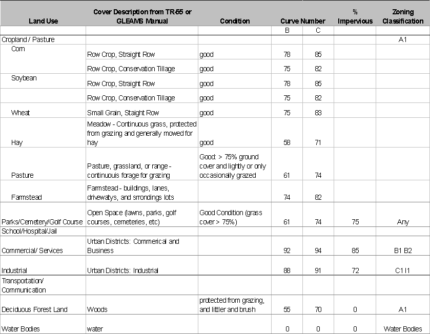
 * Adjusted
for roads and right-of-ways
* Adjusted
for roads and right-of-ways
Appendix B. Calculations
Curve Number and Percent Impervious Residential Subdivisions
(Modified from Central Massachusetts Region Planning Commission)
http://www.ci.grafton.ma.us/planning/buildout/buildout-methodology.html
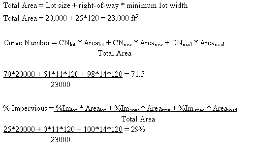
Calculations shown for 1/2 acre lots HSG B for example: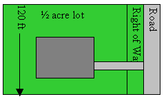
Constants from Zoning Ordinances:
Right-of-way - 50 ft
Pavement widths - 24, 28 or 34 ft
Minimum Lot Width - 120 ft
Assumptions
- 28 ft road width, allows for larger collector roads therefore
- Use CN for ˝ acre lot 70/80
- Use % Impervious for ˝ acre lot - 25%
- Use grass/pasture CN for Right-of-way - 61/74
The Curve Number and percent impervious area is a weighted average of the Curve
Numbers in the drawing above. Note, only ˝ of the road and right-of-way are
used (14 ft and 11 ft respectively); the other half is for the house across
the street.
| Lot Size |
For Lot from TR-55 |
For subdivision, adjusted for roads and right-of-way |
|
Curve Number
|
Percent Impervious
|
Curve Number
|
Percent Impervious
|
|
B
|
C
|
B
|
C
|
| 1/4 |
75 |
83 |
38 |
76.2 |
83.8 |
41.1 |
| 1/3* |
72 |
81 |
30 |
73.7 |
82.1 |
34.3 |
| 1/2 |
70 |
80 |
24 |
71.5 |
81.0 |
29 |
| 1* |
68 |
79 |
20 |
69.5 |
80.0 |
23.8 |
* These lot sizes were used in the Proposed Planned Growth
Zoning Scenario. No minimum lot sizes were given and thus, the lot was assumed
to be square.