Abstract
Data and information are essential components of day-to-day environmental decision-making and planning. Effective and successful integrated coastal zone management (ICZM), for example, requires access to both archival and current data and information. In the United Kingdom (UK), coastal zone management is undertaken by a wide variety of government and non-government agencies and institutions who are guided and co-ordinated by voluntary forums or partnerships for specific areas of the coastline. Although many of these organisations gather data and information relating to the coast, often it is not stored in a standard or accessible format for people to use outwith that particular agency. The Internet now offers a way for people to create a centralised repository or database of data, or to network disparate data sets held in various different locations and on different computers. Esri’s ArcIMS 3 map server provides the capability with an Internet connection via a web browser to access data and information, to view, manipulate and analyse it, without the need for expensive GIS software or expertise. In the summer of 2000, an initiative involving the authors, Esri (UK), and Bartholomew was undertaken to build the UK Coastal Map Creator (http://www.theukcoastmap.com). This uses Esri’s ArcIMS 3 software to deliver maps and data, specifically designed for users and managers of the UK coastal zone, over the Internet. Bartholomew 1:200,000 raster data forms the navigational base map for the system with their postcode and gazetteer data providing the end-user with the ability to search the database either by town name or postcode. Other datasets included on the site are English Nature’s boundaries of national and international conservation site designations in England. In the future, other data, such as aerial photography, satellite imagery and LiDAR will be added to the system, making it a truly geo-spatial coastal information resource for the UK coastal community.
Introduction
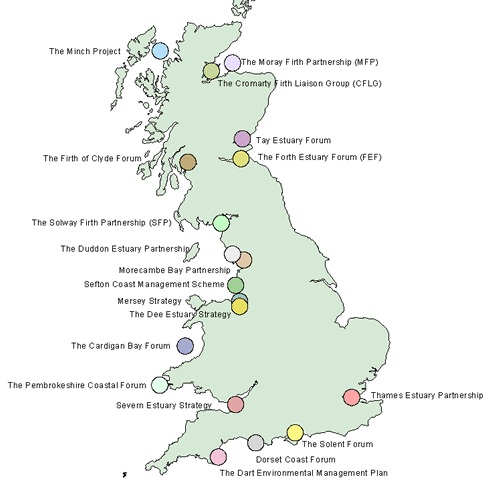
In the United Kingdom, Integrated Coastal Zone Management (ICZM) has increasingly been ‘devolved’ to the local and largely voluntary partnerships who are responsible for the management or ‘upkeep’ of their particular stretch of coastline and related hinterland. Such partnerships are generally made up of government and non-government agencies and organisations, as well as other voluntary conservation or interest groups that represent a fairly wide cross-section of coastal resource users, including the commercial sector. In Scotland, Scottish Natural Heritage (SNH) (a government agency tasked with advising the Government and others about the management and use of the natural heritage, and to carry out executive tasks on behalf of the Government (Maslen et al., 1996; Atkins, 1999) helped to initiate the ‘Focus on Firths’ project which resulted in the creation of a number of voluntary partnerships concerned with the management of Scotland’s firths. Today, successful partnerships exist for the Cromarty, Moray, Tay, Forth and Clyde Firths as well as the Solway Firth on the English and Scottish border. Similar projects have also been set up for many of the major estuaries in England, including the Mersey, the Dee, the Severn and the Thames under English Nature’s Estuary Management Plans initiative (see Figure 1).
Figure 1. Map Showing Some of the Coastal Partnerships that exist in the UK today
In the current coastal management climate of the United Kingdom (UK), information must be easily accessible to partnership project managers so that they can answer questions from all interested members within a partnership. Partnership members also require a facility to provide answers to queries that may affect their own coastal related activities (such as leisure, business or conservation) (Maslen et al. 1996). Management of the coastal environment is closely related to the physical and human geography of the coast; the form that it takes, the processes operating there as well as its use for activities such as leisure and industry. Coastal management is also about understanding spatial and temporal changes and processes as both the physical and human geography of the coastal environment are dynamic over both space and time. Geography therefore matters in coastal zone management, because "knowing where things are [and how they interact with each other] is essential to rational decision-making" (Esri, 1998, p.1). It is because ‘Geography Matters’ that Geographical Information Systems (GIS) are uniquely positioned as the ‘vehicle’ by which coastal managers can store, retrieve, analyse and disseminate the data and information that is so crucial to many aspects of their job.
However, there are several reasons why GIS on a desktop platform is not always the most viable, practical or particularly good solution for many coastal managers and/or 'forum' members. Firstly, a desktop GIS is generally an expensive item of software requiring expensive and sophisticated hardware and accompanying peripherals. Secondly, it often requires a steep learning curve for people who either may not be GIS experts, who may not be particularly IT literate, or who may not have the time to learn the software in order to utilise it fully. In other cases, day to day access to the GIS software and hardware may be restricted by the number of licences or hardware platforms, thereby limiting its wider use. Finally, the current fragmentary nature of ICZM in the UK means that although there exists a great deal of coastal data and information available for use within a coastal GIS, it is usually spread between many different organisations and agencies making it very difficult to build an integrated GIS or information system unless it is in some way linked or networked. This may be possible within an agency but is unlikely to be the case inter-agency/organisation.
Nevertheless, computer networking and communications technology, essentially the Internet and World Wide Web, is increasingly making spatial data and information available via simplified GIS interfaces to many more people. In 1995, Green (1995, p.5.1.6), proposed an UK Network-Based Spatial Information System (for ICZM) which would bring together "a combination of GIS, networking, and communications technology". In pursuit of this goal, this paper describes a new initiative involving the authors, Esri (UK), and Bartholomew to build the UK Coastal Map Creator (http://www.theukcoastmap.com) using Esri’s ArcIMS 3 map server software to deliver maps and data, specifically designed for users and managers of the UK coastal zone, over the Internet. The current project demonstrates how the Internet offers a potential solution for people to create a centralised repository or database of data, or to network disparate data sets held in various different locations and on different computers. The map server software provides the capability via an Internet connection and a web browser to access data and information, to view, manipulate and analyse it, without the need for the user to have expensive GIS software or extensive expertise.
Geography, GIS and the Coast
Both physical and human geography is important to coastal zone management. Much of what we do in the coastal zone is about geography extending over both space and time. It also involves maps, knowing where things are, when and where things happen, spatial patterns and distributions, and change over time. Geography is important to coastal zone management and GIS provides a tool to study the geography of the coast, allowing us to gather geospatial data, to display, analyse, and communicate the role of geography in day to day life. This may be a simple task such as locating a feature, or it may involve a geospatial analysis integrating geographical data sets from multiple different sources such that new data or information is derived.
There are now many different types of GIS software available ranging from the simple to the complex. A GIS may simply form a store for geospatial data and information, allowing the end-user to input data, to query, retrieve and display data and information. Alternatively it may be a sophisticated system with a considerable range of geospatial functionality that requires the end-user to know a great deal about spatial data handling, geostatistics, processing and analysis. Recently, GIS has migrated to the Internet. Although the technology for the Internet is advancing very rapidly, the current form of Internet-based GIS is an online map display, query and retrieval system with limited GIS functionality compared to more powerful desktop systems.
Together, the combination of geography and GIS provides a firm foundation upon which to build an understanding of the role of geospatial data and information in coastal zone management. Internet-based GIS currently offer a unique and valuable solution to the requirements of coastal partnerships with multiple users who require access to both data and information for a wide variety of tasks ranging from search, retrieval and display, to data analysis and visualisation.
Who is the coastal community?
The overall objective for developing any type of widely accessible information system must be to make it usable by the majority of its target audience. This does not mean reducing the level of technology or the range of functionality in the architecture of the system, but rather developing the architecture so that it is both usable now and can also be expanded in the future.
Understanding who the potential user of such a system will be is a very difficult task. Indeed, the very nature of the World Wide Web (WWW) means that the likely end-user could potentially be anyone who has access to a computer, web browser and Internet connection. Preece (2000) has argued that "[I]t goes without saying that users come in all shapes and sizes, with different personalities, abilities, experiences, resources and needs" (p.124) and further suggests that how people will access and use a web site may depend upon:
There is no reason to suggest that users of a coastal information system will be any different in these respects from any other identifiable end-user group. It is certainly clear that the members of the coastal partnerships who currently make up the greater part of the UK coastal management community are drawn from a whole range of backgrounds and cover a wide spectrum of the general public.
These include representatives from the government, commercial, academic, and individual sectors. Each of these on its own provides a very varied end-user community, ranging from the specialist to the scientist, to the consultant, to the retired, to the educator. Together they constitute the 'community' that is interested in monitoring and managing the estuary or the coastline.
Whilst some of these potential end-users are IT literate, many are not and this is borne out by a recent survey questionnaire undertaken by the authors. However, trying to convince the target audience to make greater use of an Internet-based information system will necessitate careful consideration of the assumptions that can be made about the end-user community and the design of the user interface to the data and information resource.
The Internet – A Networking Solution
The historical basis of the computer network was to allow resources to be shared between different users based in different geographical locations. The Internet and World Wide Web is an evolution of the original computer network, allowing a user to connect to many different computers (servers) across the world to retrieve information from them or to download data and even software. The ability and ease with which this is now done is largely due to the hypertext capability developed by Tim Berners-Lee in 1980. It is perhaps of little surprise that GIS vendors have taken advantage of this technology by moving GIS software onto the Internet where it is available to more users at a reduced cost. Longley et al. (2001) suggest a number of reasons why the Internet has proved to be a popular vehicle for delivering GIS applications. These include:
For the coastal management community in the UK and elsewhere, it has meant that there is now the potential to access distributed data sources from different agencies and organisations within a coastal partnership or from across the country and process it within a simplified user interface.
The User Interface
The user-interface is a crucial, if not the most important, factor determining the success of any hardware, software or system use. As such it must be a primary consideration when developing an information system as it will govern whether or not people are able to access the information they need.
The interface is crucial to the success of usability in practice. If the interface works well, the end-user will make use of the system. However, if it does not work well, then the end-user may not be encouraged to make use of the system, and will become frustrated, bored, and disinterested.
As discussed earlier, and confirmed by a recent survey questionnaire, the end-user community is a very wide ranging one with very different levels of knowledge, familiarity, competency, access to computer platforms, browsers, age, experience, frequency of use, and requirements as well as personal preferences and cultural differences. Furthermore, today end-user expectations are also very high, something that has resulted from the perception of what the technology can do 'so easily' for them.
The interface is
an 'intermediary', an 'interpreter' and 'guide', with a 'logical structure'
and meaning, designed to provide a 'cohesive end-user experience. It theory
they provide the 'filters' between the computer and the end-user, a 'service',
and acts as an 'interactive partner'. In practice, they provide navigational
control, access to specific functionality, and to context-specific tasks e.g.
analysis.
But what defines the user-interface? Interfaces to IT are often very different and are constantly evolving. How is it possible to come up with an interface that suits all end-users? The desirable trend now is towards the development of 'simpler' interfaces, despite the increasing complexity of the application and likely increased functionality that this necessitates. Yet, is it possible to have a simple interface to a complex software package? One design principle of the user-interface is that 'What we do for the (computer, PDA etc.) Screen is for and about people' (Fleming, 1998, Chapter 5). What does this mean in practice?
In reality, there are a number of potential difficulties facing the designer of user-interfaces to any software, and moreover Internet-based online information systems, which will determine success. These include: the end-user community profile; technology often promises more than it can deliver; the hardware platform e.g. desktop PC, PDA, mobile phone; screen size; the growing complexity of the software and its functionality, e.g. navigation, analysis; modem communication speeds; the metaphor e.g. desktop, map, overlay, landscape, world, conversational; mode of interaction e.g. keyboard, mouse, touch screen, sound/voice; access to easy to use software for creating and customising Internet websites and interfaces.
In reality, more often than not, many end-users are not as proficient with IT as might be assumed, and find they have to spend a great deal of time and cognitive resources just learning to learn an interface, to navigate it, and ultimately to use the functionality. The growing complexity of technology and software functionality, the available platform, screen size, and physical limitations to the technology e.g. the use of PDAs (images, graphics, memory, colours, power supply, screen size, wireless connection and bandwidth (9.6 kbits/s) for presentation of WWW pages are often insufficient with respect to quality and access time and may create considerable end-user frustration. Metaphors are intended to be 'sense-makers' mapping the 'source' to 'target'. In practice, different metaphors are appropriate for different things e.g. navigation, tasks etc. Ideally too, metaphors should facilitate critical thinking but without hindering the thought processes. However, metaphors can get in the way of thinking. Furthermore, it is now frequently recognised that WIMP 'point and click' metaphor can not control all aspects of potential use. Where sophisticated visualisation techniques, e.g. a landscape metaphor, are used as part of the interface, end-users may find it difficult to relate to user-experiences e.g. Virtual Reality 'fly-throughs'. Another question that must be asked is How appropriate are the current interaction techniques for 'everything' we want to do? Most people get used to using a mouse, but touch screens are often better for public information systems. Yet, how easy is it to use to navigate a system with a 'finger' instead of the mouse?
What are the solutions? Alternative interfaces are one possible solution; Social User-Interfaces / Conversational User-Interfaces / User-Interface Agents / Avatars / VRML 3D Worldlets are all available and operational now, but most are experimental and once again do not suit every end-user.
It is undoubtedly a significant challenge to provide interfaces to systems, software applications and the Internet. This problem will become more important in the coming years as the technology evolves, and will need to be addressed as the end-user community grows to enable use of the resources in a number of different ways e.g. information retrieval and display to processing, analysis and visualisation of data. But, how can all the potential end-users be accommodated? How can the perceived user-unfriendliness of an interface be overcome? Understanding how the end-user community works is a difficult task. So, how is it practically possible to help improve user-interfaces? There is a vast amount written on interfaces for software, but less so for the Internet at present. Web guidelines provide a sound and well-documented resource for reference. The creation of different user-interfaces for different applications and for different end-users are all other possible solutions. Moreover, understanding and working with the technology, together with usability testing is one approach that is currently being encouraged and may help to focus research on issues that will facilitate more engaging user-interfaces for the end-user.
The UK Coastal Map Creator
The UK Coastal Map Creator is a joint initiative between the authors, Esri (UK) and Bartholomew Maps. The system was initiated because of the statements made by David R. Green (Green, 1995) in recent years about the need for simplified access to and analysis of coastal data and information for integrated coastal zone management. It also came about due to the current research being carried out by the authors into the development of an integrated Internet-based coastal decision support system for the Solway Firth in the United Kingdom, and also because Esri (UK) invited ideas for applications to demonstrate the utility of the ArcIMS Internet mapping software. Bartholomew have created a raster 1:200,000 map data set covering the whole of the UK and it is used by many Internet-based mapping companies as a base map for their systems. They agreed to supply the whole data set for use in this system as well as their postcode and gazetteer database to enable postcode and name searches of the map. The following outlines how ArcIMS was used in conjunction with ArcView 3.2 to design and implement the UK Coastal Map Creator on-line GIS.
Designing the GIS and Map Interface
The UK Coastal Map Creator web site was designed and developed by the authors. The ArcIMS 3 software was installed on to an Intel Pentium III based server with 256Mb of RAM running Microsoft NT 4.0 Server and Internet Information Server 4.0. The ArcIMS software was installed using the default settings which consequently helped the process of transferring the system and site onto a more accessible server managed by Esri(UK).
The mapping interface was initially developed using the ArcIMS Author within ArcIMS Manager (see Figure 2).
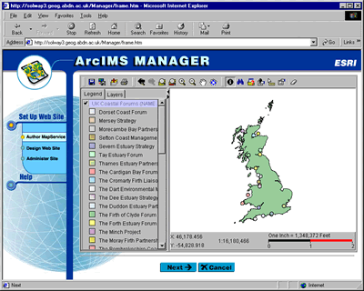
Figure 2. Designing the Map Service and Interface within ArcIMS Manager
Data layers (Shape Files and raster data) were added to the Map File from a local Data Source (the hard drive on the server). These included:
Files based on 100km squares
All data for England
A number of the data layers were made scale dependent so that they would only display at certain zoom levels. This is shown in the table below:
Table 1: Scale Properties of Data Layers
| - |
Layer Shows |
|
|
Layer Name |
Never Below |
Never Above |
| - | - | - |
|
The UK Coast |
1:200,000 |
1:1,000,000 |
|
SPA |
1:40,000 |
1:200,000 |
|
SAC |
1:40,000 |
1:200,000 |
|
Ramsar |
1:40,000 |
1:200,000 |
|
NNR |
1:40,000 |
1:200,000 |
|
SSSI |
1:40,000 |
1:200,000 |
|
Character Areas |
1:40,000 |
1:200,000 |
|
Natural Areas |
1:40,000 |
1:200,000 |
|
Raster Map Tiles |
1:40,000 |
1:200,000 |
Setting the scale factor on the different layers helps to aid navigation of the map by reducing the amount of detail shown at small scales and only increasing the amount of detail as a user zooms in on an area of interest and the scale becomes larger. This also helps reduce download times when the user initially loads the map interface. Other layer properties were also customised using ArcIMS Author, such as colour, labels and layer order.
Publishing the Map Service and customising its Features
Once the basic Map File was created, ArcIMS Manager was then used to publish the MapService. An ImageMapService was chosen rather than a FeatureMapService as most of the processing is carried out on the server rather than the client machine. The basic map site was then designed using the Designer function within ArcIMS manager. It is at the design stage that the functionality of the map site is decided upon. Although the overall aim of the site was to provide a reasonably simple interface into an on-line GIS, it was also imperative that the site had some GIS functionality as well, rather than being just a simple map delivery system, so that users would be able to switch layers on and off, as well as interrogate attribute information associated with those layers. Other GIS tools that are enabled on the site include:
The ArcIMS Designer feature produces an Internet-based GIS that is ready to ‘go-live’ complete with all the required JavaScripts, HTML pages and images. However, the web pages that are created can be customised relatively easily to complement the rest of a web site and the designated application that the site is serving. The full list of files that can be modified is described in the Esri Manual ‘Customizing ArcIMS’. Apart from changing the colours of the basic web viewer, the tool buttons were also redesigned to give them a more ‘friendly’ look for the non-GIS user who is not acquainted with the ‘standard’ ArcView type buttons that are the default setting. Another less-visual but important functional customisation included limiting the fields displayed when a data layer is queried so as to remove unnecessary information.
Other Pages on the Web Site
The UK Coastal Map Creator web site also contains pages (see Figure 3.) that describe what the site is about, including contact information, a disclaimer about use of the site and the data held within it, a ‘Data Shop’ providing an on-line catalogue of the data sets used and where they may be purchased and downloaded, a help page (see Figure 4.) describing how to use the mapping application, and a page with links to information about coastal management, mapping and GIS. The map interface is also launched from the main web site into a new browser window that is set at 750x480 and is not resizable. There are a number of advantages for users in using the ArcIMS HTML viewer in this way. No one user will have the same system configuration on their computer. They will be using different browsers, different sized monitors and screen resolutions. For those who are using a large monitor and a high screen resolution set-up, opening the ArcIMS viewer into a full size browser window can be quite time consuming if the viewer is being downloaded via a modem. On the other hand, a user with a smaller screen and lower resolution set-up could find that the ArcIMS viewer takes over their whole screen or does not even fit it. Moreover, the current version of ArcIMS does not resize maps correctly if the browser window is resized (although it does in Netscape Navigator). Therefore setting the window size can help to find a happy medium for most users. Finally, the new window leaves the main site open so that the user can easily navigate back to the image catalogue or help files.
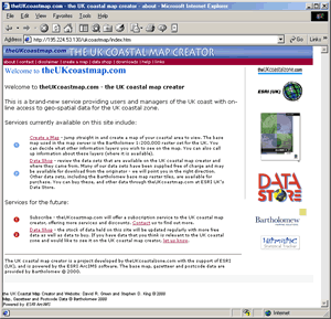
Figure 3. The UK Coastal Map Creator Home Page (http://www.theukcoastmap.com)
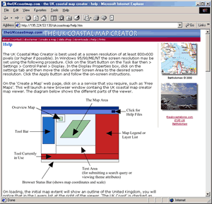
Figure 4. The UK Coastal Map Creator Help Page
Using the UK Coastal Map Creator
The basis of the UK Coastal Map Creator is to offer a national geo-spatial data and information resource to coastal managers and users in the UK, as well as some on-line GIS functionality. In a typical scenario, a coastal manager would access the site looking for data that they would be able to use in helping to make a management decision. At a very simple level, this might be locating a particular place, area, or feature on a map. In the UK Coastal Map Creator, this can be done by interactively zooming in on the base map, or by searching the map using either a place name or a postcode (see Figure 5) (using the Bartholomew Great Britain Gazetteer). At perhaps a more detailed level, the user can then add in additional layers of data and query them. For example a coastal manager in assessing a potential marina development could locate the area of interest, and then add in layers such as Sites of Special Scientific Interest (SSSIs) or Special Protection Areas (SPAs) and analyse them in respect to their proximity to the proposed development. A basic analysis might include interrogating the layer with the ‘Identify’ tool to retrieve attribute information about the layer and then use this in a report (see Figure 6).
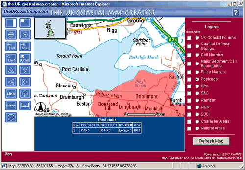
Figure
5. Locating an Area by Searching for a Postcode
ArcIMS Allows the User to Move to the Selected Area that is Retrieved
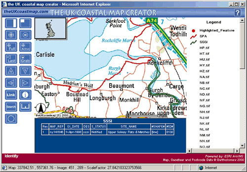
Figure
6. Adding Extra Data Layers and then Interrogating them Using the Identify Tool
In this Case, Information is Retrieved about an SSSI
Problems to be Overcome
Although the UK Coastal Map Creator has made progress in taking the idea of a UK Network-Based Spatial Information System for ICZM forward, and has put some of the theory into practice, there are still a number of significant problems and challenges that need to be met and resolved. These lie with the data, the technology, the coastal user community, and coastal management legislation.
The Vision and the Future – A Discussion of Technology in ICZM in the UK
The UK Coastal Map Creator has gone some way to providing the UK Networked-Based Spatial Information System for ICZM first proposed by Green in 1995, and has fulfilled some of the vision that was set out in that proposal as well as many others that have followed. It is important to recognise, however, that this proposal was made only two years after the first ever interactive map system was developed for the Internet in 1993 (the Xerox PARC Map Viewer developed by Steve Putz http://mapweb.parc.xerox.com/map see Longley et al. 2001, p.14-15). Since then, both the Internet and Internet-based GIS have rapidly developed so that today they are both more highly accepted and utilised by many more people, and they are also much more powerful and functional.
As stated earlier in this paper, any system such as this must be developed with the end-user in mind, and also based upon the current technology that is available to the majority of users at the present time (although this is unlikely to be the most up-to-date technology available as there is always a time lag between the technology being made available and it being adopted). However, it is also important to look ahead to the future and not just to consider only the present or the past. With the ever growing demand for information, end-users will increasingly be able to access it via the Internet on desktop machines. Also, mobile communication devices such as Portable Digital Assistants (PDAs) and Wireless Application Protocol (WAP) devices such as mobile phones will become more commonplace (see Figure 7). In this sense, data and information is rapidly being made available to anyone, anytime and anywhere. It is therefore vital that coastal managers embrace this technology for better, more efficient and more effective decision making in the coastal zone.
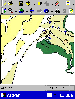
Figure
7. Accessing an ArcIMS Map Service with Esri’s ArcPAD 5.0.1 Using a
Compaq Aero 2160 PDA and Nokia 6210 Mobile Phone with IR Port and Modem
However, in order to allow such a vision to become reality there will need to be far greater cooperation and willingness to share data and information and to sell it a more reasonable rate in the future. This particular statement may seem to reiterate many others made over the years and to conjure up a sense of 'deja-vu'. But these issues are hindering delivery of the considerable benefits offered by this exciting technology. But there are other issues preventing progress. The way the Internet is delivered to UK customers will also have to change, primarily to low-cost but mass use unmetered and broad-band access. Legislation in the UK may also have to change so that coastal zone management is given more centralised government support enabling management decisions to be enforced, but also so that data and information gathering, retrieval and dissemination is more coordinated. Finally, the potential end-user has to become more aware of what the technology can do for them, and become more able to use it successfully through raising awareness and education. This will have to involve better geographical and IT education, so that future generations can utilise the present technology but also adapt to whatever comes next.
Technology enables and empowers people to do their job more effectively and efficiently. Access to data and information facilitates knowledge and understanding. Together they offer an integrated work environment for coastal zone management.
References
Atkins, S. (1999)
Involvement of Local Communities in Integrated Coastal Management of Scotland’s
Firths
(http://www.ramsar.org/cop7181cs18.doc)
Esri (1998) Geography Matters, Esri White Paper, June 1998
Fleming, J. (1998)
Web Navigation: Deigning the User Experience, Sample Chapter 5: Interface
and Interaction Design
(http://www.oreilly.com/catalog/navigation/chapter/ch05.html)
Green, D. R. (1995) ‘Internet, the WWW and Browsers: The Basis for a Network-Based Geographic Information System (GIS) for Coastal Zone Management’, AGI’95 Conference Proceedings, 21st – 23rd November 1995, Birmingham International Convention Centre, pp.5.1.1 – 5.1.12
King, S. D. and
Green, D. R. (2000) Coastal Information System Questionnaire, University
of Aberdeen, Unpublished
(http://www.abdn.ac.uk/~geo402/quest.htm)
Longley, P. A., Goodchild, M. F., Maguire, D. J., and Rhind, D. W. (2001) Geographic Information Systems and Science, Chichester UK, John Wiley
Maslen, J., Peltenburg,
J., and Atkins, S. (1996) ‘Focusing in on the Firths: Can GIS fulfil its potential
for Coastal Zone Management?’, 1996 Esri European User Conference,
Esri(UK) 2nd-4th October 1996, London
(http://gis.Esri.com/library/userconf/europroc96/PAPERS/PN24/PN24F.HTM)
Preece, J. (2000) Online Communities: Designing Usability, Supporting Sociability, Chichester UK, John Wiley
Acknowledgements
The authors would like to thank David Maguire of Esri and Roy Laming of Esri(UK) who made the ArcIMS software available for this initiative and therefore made it possible. Also to Ed Boiling of Esri(UK) who helped to set up the Map Service and who continues to help maintain the web site. Last but not least to Bartholomew who provided the Map, Gazetteer and Postcode data.
Author Information
David R. Green
and Stephen D. King
Department
of Geography and Environment
University
of Aberdeen
Elphinstone
Road
Aberdeen
AB24 3UF
SCOTLAND
(UK)
Tel. +44 (0) 1224
272324
Fax. +44
(0) 1224 272331
Email: d.r.green@abdn.ac.uk
/ s.d.king@abdn.ac.uk
Web: http://www.abdn.ac.uk/cmczm
and http://www.theukcoastalzone.com